Waterfall Wednesday: Gabbro Falls

Gabbro Falls from Above

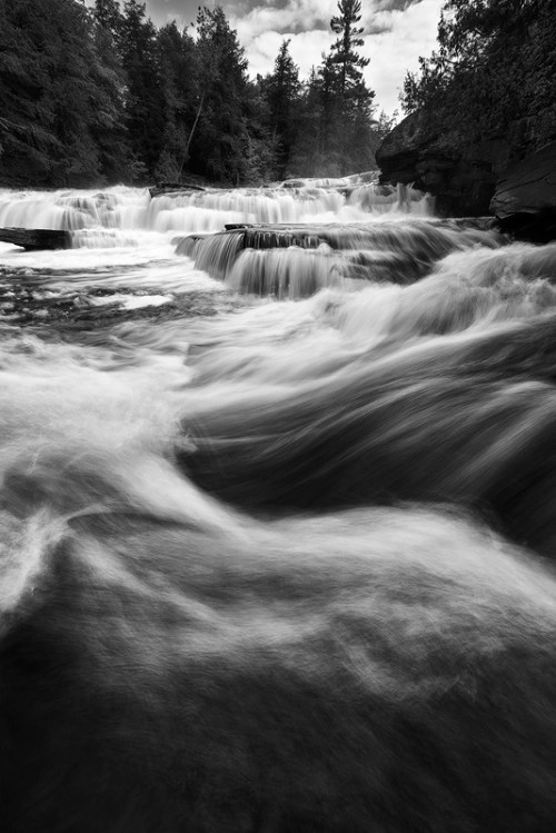
Gabbro Falls, photo by Eric Hackney Photography

In addition to stalking the Petit Portal, it appears I am stalking Eric Hackney as well.

GoWaterfalling’s page on Gabbro Falls begins:

Gabbro Falls is on the Black River and is as impressive, if not more impressive, than its more celebrated neighbors downstream along the Black River Scenic Byway. This is a largely wild waterfall with no fences or barriers of any kind. It consists of three separate drops. When the water is high there is a fourth drop that is the height of the other three combined. The main drop falls into a narrow crevice between two large rock formations.

Gabbro Falls is relatively easy to find but there is some confusing information out there. The waterfall is also known as Baker’s Falls, and it is often mistakenly called Garbo Falls (gabbro is a type of rock). There is also a Neepikon Falls upstream, but it is just an unremarkable rapid.

Read on for tips on visiting and pages about nearby waterfalls on the Black River and also be sure to check it out on GoWaterfalling’s awesome waterfall map!

View Eric’s photo background bigtacular on Facebook, see more in his 6-27-15: Gogebic County Adventures I set featuring photos of Gabbro Falls, Rainbow Falls, Potawatomi Falls, Gorge Falls and more! Definitely follow him at Eric Hackney Photography on Facebook.

More Michigan waterfalls and more summer wallpaper on Michigan in Pictures.

#TBT – Ice Caves of 2015

Icicles on cave - Grand Island Ice Curtains on Lake Superior - Munising, Michigan

Icicles on cave – Grand Island Ice Curtains, photo by Craig

As the mercury climbs and some crazy people (such as yours truly) start grumbling about the high temps, it’s probably a good time to take a look back at last winter’s spectacular ice caves.

Aubrieta Hope shared the story of her trip with Craig and two other photographers (Neil Weaver & John McCormick) to check out the Grand Island ice curtains. All four are Michigan in Pictures regulars – click to check out In Search of Superior Crystal on the Pure Michigan Blog. It has a bunch of photos and begins:

In the heart of winter, when the drifts are as high as houses and snow-dusted pines line the roads, photographers travel to the Upper Peninsula in search of crystal. Not antique-store crystal, but Superior crystal, the kind that occurs when the north wind turns every drop of open water into something sparkling and new. During the coldest months, the great lake freezes, heaves and breaks, forming mountains of crystal rocks, so tall they seem like permanent landforms. Icebergs and volcanoes rise in the harbors and bays, reflecting all the colors of the sky. Waterfalls slow from a rush to a trickle, building columns that bubble and sing. And, on the sandstone cliffs, springs that flow unseen in the summer months create glittering ice curtains.

During winter’s last stand, at the very beginning of March, I headed north to find Superior crystal. My trip was inspired by winter photographs of the U.P. that I’d viewed online. I’d seen dramatic images of enormous frozen waterfalls, great Superior ice fields, and shining rivers wreathed in morning mist. I wanted to experience and photograph all those scenes, but more than anything, I wanted to see the legendary ice curtains of Grand Island in Munising Bay. These immense, aqua blue ice curtains form when cold temperatures freeze the springs that seep from the island’s rocky cliffs. It can be tricky to get to the ice curtains, though. The island is not accessible every winter because the currents are strong in the bay, preventing adequate ice buildup. During last year’s historically cold winter, the bay froze sufficiently to allow foot traffic. For awhile it looked like Grand Island would not be accessible this year, but February’s arctic blast arrived just in time.

View Craig’s photo bigger and see & purchase more in the Grand Island Ice Curtains – Munising gallery on Craig’s website.

PS: The Grand Island National Recreation Area is located just off the coast of the UP in Munising and is an amazing place, complete with mountain bike trails!

PPS: More ice caves on Michigan in Pictures too!

PPPS: I really am a fan of the PS. If you are too, please PS in the comments!

When Day and Night Collide

When Day and Night Collide

When Day and Night Collide, photo by Eric Hackney

We got some great Northern Lights last weekend, and so far summer 2015 has been great for the Aurora Borealis.

Eric took this stunning photo at twilight Saturday on Great Sand Bay. View it bigger and see more in his 7-11-15: Northern Lights III slideshow.

The Michigan Tech Geology Department’s page on Great Sand Bay says (in part):

This is a remarkable geological site, with many excellent examples of features to see.  There is a low energy beach with offshore sandbars, sheltered by a dramatic headland.  The headland is part of a resistent lava layer from the Lake Shore Traps, where there are underwater copper rich veins which cut across. A large copper boulder was removed for the display at Quincy Mine, but much remains of veins for diving here in the Underwater preserve.

Inland, within the Redwyn Dunes and George Hite Dunes are Coastal Dune Ecosystems with many perched dunes and vernal pools.  Perched dunes are dunes that are located above glacial deposits, moraines, outwash or glacial lake deposits. In this place vernal pools are between dunes and above post glacial lake materials.  All this makes for an unsual environment, well worth visiting. A 1 hr trail at Redwyn covers these features well.

Read on for lots more including photos, maps and aerials and get tons more about the Northern Lights including viewing and prediction tips on Michigan in Pictures!

The Seagull Signal

Independence Sunset

Independence Sunset, photo by Cory Genovese

These amazing sunsets we’ve been seeing lately are the result of smoke from Canadian & Alaskan wildfires – perhaps that’s what the mayor of Marquette trying to signal Seagull Man about!

View Cory’s photo from before the Marquette fireworks bigger and definitely follow him on Facebook.

More from Marquette and lots more sunsets on Michigan in Pictures.

Superior Sunset from Little Presque Isle

Superior Sunset

Superior Sunset, photo by Mark Stacey

The Michigan Department of Natural Resources has nominated Little Presque Isle for dedication (explanation). It’s located on the Superior shore 7 miles north of Marquette and they explain that the Little Presque Isle tract:

…is often called the crown jewel of Lake Superior, with its beautiful sand beaches, rugged shoreline cliffs, heavily timbered forests, and unmatched public views. The proposed natural area occurs north and south of Little Presque Point, around the mouth of Harlow Creek. The area is a combination of a wooded dune and swale community and bedrock lakeshore and cliff. The wooded dunes and swales formed as post-glacial lake levels receded, depositing a series of low sandy beach ridges. Since then, the ridges have become forested with hemlock, red pine, white pine, cedar, and balsam fir, while the wet swales that developed between them are now either forested or open wetlands.

The rock comprising the area represents some of the oldest exposed formations of its kind. More than a mile of bedrock lakeshore and cliffs adorns Little Presque Isle, including sandstone cliffs that reach nearly 60 feet high toward the base of Sugar Loaf Mountain. One kind of bedrock, granitic, that occurs here is the least common bedrock type along the Great Lakes shoreline, with less than eight miles occurring in total. This is one of three areas where the public can see these 2.3 billion year old formations in Michigan.

The proposed wilderness area is a local landmark, which has significant historical value. The island was reportedly connected to the mainland sometime prior to the 1930s and was a landing place for early explorers and native inhabitants. Roughly 100 yards off the mainland, the island is accessible by wading hip deep water and offers and opportunity for solitude in a unique and scenic setting.

View Mark’s June 2012 photo from Little Presque Isle bigger and see more in his really cool Michigan’s Upper Peninsula slideshow.

Kitch-iti-Kipi: Michigan’s Largest Spring at Palms Book State Park

Big Spring (Kitch-iti-Kipi) Palms Book State Park

Big Spring (Kitch-iti-Kipi) Palms Book State Park, photo by Michigan Nut Photography

How about a big “way to go!” to the State of Michigan for a complete revamp their previously not very good Michigan Parks & Trails site? The new site is miles better!! The Palms Book State Park page says:

Palms Book is a rewarding side trip for the vacationer touring the Upper Peninsula, for here can be seen one of Michigan’s alluring natural attractions — Kitch-iti-kipi, The Big Spring. Two hundred feet across, the 40-foot deep Kitch-iti-kipi is Michigan’s largest freshwater spring. Over 10,000 gallons a minute gush from fissures in the underlying limestone. The flow continues throughout the year at a constant 45 degree Fahrenheit. By means of a self-operated observation raft, visitors are guided to vantage points overlooking fascinating underwater features and fantasies. Ancient tree trunks, lime-encrusted branches and fat trout appear suspended in nothingness as they slip through crystal waters far below. Clouds of sand kept in constant motion by gushing waters create ever-changing shapes and forms, a challenge to the imagination of young and old alike.

The legend of Kitch-iti-kipi is said to be about a young chieftain whose girlfriend got the best of him. He told her he loved her far above the other dark-haired maidens dancing near his birch bark wigwam. Prove it, she insisted. As a test of his devotion, she declared that he must set sail in his canoe on the pool deep in the conifer swamp. He was to catch her from his canoe as she leaped from an overhanging bough. His canoe overturned in the icy waters and he drowned. It turns out that the maiden was back at the village laughing at his foolish quest. According to legend, the Spring was named Kitch-itikipi in memory of the young chieftain who went to his death in the icy waters in an attempt to satisfy the vain caprice of his ladylove.

Other legends tell of Chippewa parents who came to the pool seeking names for their newborn. They supposedly found names like Satu (darling), Kakushika (big eye), Natukoro (lovely flower) and We-shi (little fish) scribed in the sounds of the rippling water. They attributed healing powers to the waters.

A drop of honey on a piece of birch bark dipped into Kitch-iti-kipi and presented to a loved one was to make them true forever. Another legend concerned the tamarack growing on the banks of Kitch-iti-kipi. A small piece of the bark ground in a mortar and pestle and placed in an individual’s empty pockets would be replaced by glittering gold at exactly midnight. Whatever the legends, visitors to the spring loved them. Kitch-iti-kipi is said to have many meanings in the Chippewa language-The Great Water; The Blue Sky I See; The Roaring, Bubbling Spring. Others called it the Sound of Thunder and Drum Water, even though the quiet is eerie. Whatever its name and legend, Palms Book State Park continues to draw curious visitors.

Although it was a black hole all but hidden in a tangle of fallen trees, John I. Bellaire fell in love with the Big Spring in the early 1920s…

Read on for the story of how it came to be a state park along with maps, photos and park events.

View John’s photo background big, purchase this photo and definitely follow him at Michigan Nut Photography on Facebook.

More Michigan parks on Michigan in Pictures!

#TBT: Atop Miners Castle

Atop Miners Castle

Atop Miners Castle, photo by Roger Dinda

On April 13, 2006 one of the most recognizable rock formations in the Pictured Rocks National Lakeshore, Miners Castle collapsed. The Lakeshore explains:

On Thursday morning, April 13, 2006, the northeast turret of Miners Castle collapsed. One turret remains on Miners Castle, the best-known feature of Pictured Rocks National Lakeshore. The collapse was reported via cell phone by fisherman in the area, according to chief ranger Larry Hach. Most of the rock fell north and into Lake Superior, and there were no injuries. The lower overlook platform near Miners Castle appears to be unaffected.

While the rockfall at Miners Castle on April 13 was startling, such events are not rare along the Pictured Rocks escarpment. At least five major falls have occurred over the past dozen years: 1) two different portions of Grand Portal Point, 2) the eastern side of Indian Head just east of Grand Portal Point, 3) Miners Falls just below the (now modified) viewing platform, and 4) beneath the lip of Munising Falls (along the former trail that went behind the cascade).

All the rockfalls involved the same rock unit, the Miners Castle Member of the Munising Formation. Rock units are named for places where they were first technically described. The Miners Castle Member consists of crumbly cross-bedded sandstone that is poorly cemented by secondary quartz, according to U.S. Geological Survey Research Ecologist Walter Loope.

Rockfalls along the cliffs typically occur in the spring and fall due to freezing and thawing action of Mother Nature.

Joel says that this photo was taken Roger Dinda in 1961 or ’62 “…before Pictured Rocks was a National Lakeshore, before Miners Castle lost its second turret, before they put up the boardwalks and railings. In this photo I’m just as tense as I look. I am deathly afraid of heights and this was (still is) about the scariest place I’ve ever been.”

View his photo background big more in his Lake Superior slideshow.

There’s more Throwback Thursdays, more Miners Castle & more from the Pictured Rocks National Lakeshore on Michigan in Pictures!

Waterfall (and Wayback) Wednesday: Potawatami Falls & Michigan’s Potawatami Tribe

24 Potawatomi Falls

24 Potawatomi Falls, photo by David Hedquist

GoWaterfalling’s page on Potawatomi Falls shares:

A very scenic waterfall along an especially scenic part of the Black River. An added plus is the close proximity of the equally impressive Gorge Falls. These are two of the most impressive falls on the Black River and are also the two easiest to access.

Potawatomi Falls is just upstream of Gorge Falls and is reached from the same parking area. Potawatomi is the name of one of the native tribes. This waterfall is wheelchair accessible. Gorge Falls is just a short walk away.

In low water, the waterfall is segmented, with most of the water going to the right. In high water the river covers the entire rock separating the two segments with a sheet of white water.

Head over to GoWaterfalling for directions and more. In case you were wondering (as I was), here’s a bit of Potawatomi history from Lee Sultzman that explains (in part):

In 1600 the Potawatomi lived in the northern third of lower Michigan. Threatened by the Ontario tribes trading with the French (Neutrals, Tionontati, Ottawa, and Huron) during the late 1630s, the Potawatomi began leaving their homeland in 1641 and moved to the west side of Lake Michigan in northern Wisconsin. This was completed during the 1650s after the Iroquois defeated the French allies and swept into lower Michigan. By 1665 all of the Potawatomi were living on Wisconsin’s Door Peninsula just east of Green Bay. They remained there until 1687 when the French and Great Lakes Algonquin began driving the Iroquois back to New York. As the Iroquois retreated, the Potawatomi moved south along the west shore of Lake Michigan reaching the south end by 1695. At about the same time, one band settled near Jesuit mission on the St. Joseph River in southwest Michigan. Shortly after the French built Fort Ponchartrain at Detroit in 1701, groups of Potawatomi settled nearby. By 1716 most Potawatomi villages were located in an area between Milwaukee to Detroit. During the 1760s they expanded into northern Indiana and central Illinois.

Land cessions to the Americans began in 1807 and during the next 25 years drastically reduced their territory. Removal west of the Mississippi occurred between 1834 and 1842. The Potawatomi were removed in two groups: the Prairie and Forest Bands from northern Illinois and southern Wisconsin went to Council Bluffs in southwest Iowa; and the Potawatomi of the Woods (Michigan and Indian bands) were relocated to eastern Kansas near Osawatomie.

View David’s photo background bigtacular and see many more photos and some videos in his Potawatomi Falls slideshow.

PS: David is the author of Waterfalling in Wisconsin: The Complete Guide to Waterfalls in the Badger State. I’m seeing a bunch of photos of Michigan waterfalls, so (maybe) stay tuned!

Requiem for a Spruce: Spruce Budworm in Michigan

April 11, photo by Michael Koole

April 11, photo by Michael Koole

Garret Ellison of the Grand Rapids Press & mLive writes that the Michigan Department of Natural Resources expects spruce budworm to inflict heavy damage on white spruce and balsam fir trees across the Upper and northern Lower Peninsulas this year:

The budworm is “one of the most destructive native insects” in the northern spruce and fir forests of the eastern U.S. and Canada. The worms drop as caterpillars from treetops on webs and feed on tree growth in the spring.

Repeated budworm defoliation can cause top-kill and death in older and stressed trees. Balsam fir older than 60 and spruce over 70 years are prime targets. Younger trees infested with budworms lose much new growth but generally survive.

Read on for more, including how to protect your trees. The U.S. Forest Service has more about the spruce budworm:

The spruce budworm Choristoneura fumiferana (Clemens) is one of the most destructive native insects in the northern spruce and fir forests of the Eastern United States and Canada. Periodic outbreaks of the spruce budworm are a part of the natural cycle of events associated with the maturing of balsam fir.

The first recorded outbreak of the spruce budworm in the United States occurred in Maine about 1807. Another outbreak followed in 1878. Since 1909 there have been waves of budworm out breaks throughout the Eastern United States and Canada. The States most often affected are Maine, New Hampshire, New York, Michigan, Minnesota, and Wisconsin. These outbreaks have resulted in the loss of millions of cords of spruce and fir.

Balsam fir is the species most severely damaged by the bud-worm in the Eastern United States. White, red, and black spruce are suitable host trees and some feeding may occur on tamarack, pine, and hemlock. Spruce mixed with balsam fir is more likely to suffer budworm damage than spruce in pure stands.

If you’re intrigued by the “natural cycle” as I was, head over to Wikipedia’s entry on Choristoneura fumiferana, the Eastern Spruce Budworm for an explanation and some pics of these (for a change) native pests.

View Michael’s photo bigger and see more (including lots of tasty macro) in his Around the Yard slideshow.

PS: Sorry about the Monday morning novel … sometimes I over share. ;)

Waterfall Wednesday: Manido Falls in the Porcupine Mountains

Turbulence (Manido Falls, Porcupine Mountain)

Turbulence (Manido Falls, Porcupine Mountain), photo by Jiqing Fan

The Waterfall Record’s entry for Manido Falls says:

Manido Falls did not impress me at first, at least not as much as the downstream Manabezho Falls. After seeing the pictures I had taken, though, I discovered what an amazingly beautiful waterfall Manido Falls is. Its beauty comes from its complexity. The waterfall itself is not very tall at all. It is wide, though. As the Presque Isle River tumbles down toward Lake Superior, it comes to this set of rocks that create a beautifully cascading waterfall. I think what makes me like Manido Falls so much is that the water has taken such an interesting course here, erosion taking its effect in an oddly unique way.

Add to it that the just as spectacular Manabezho Falls is only hundreds of yards away, and Lake Superior not much more distant, this makes for one of the most beautiful waterfall stretches in the Upper Peninsula.

Visit #2: When my father and I visited Mandido Falls in late September 2010, the falls looked completely different due to the significant amounts of rainfall in the weeks previous.

Read on for directions and some photos.

View Jiqing Fan’s photo bigger and see more in his Houghton & UP MI slideshow.

More black & white photography and (many) more Michigan waterfalls on Michigan in Pictures!