Waterfall Wednesday: Big Pup Falls

Big Pup Falls

Big Pup, photo by Kim Nixon

Travel Marquette shares:

Big Pup Creek Falls (Lat. N46 Degrees 42′ 42″ Long W87 Degrees 42′ 14″) is located from Marquette – Travel County Road 550 north toward Big Bay approximately 23 miles to County Road 510. Travel about 7 miles (you will cross the steel bridge which spans the Yellow Dog River as directed for Yellow Dog (River) Falls). Drive approximately 2 miles farther on the winding road. Just before the bridge about 60 yard. Park safely off to the side of the road before the bridge. Walk down the hill off the road right of way to the falls.

View Kim’s photo bigger, see more in her September 2012 slideshow and follow her at Photography with Kim on Facebook.

FYI, there’s now 134 waterfall posts on Michigan in Pictures!

Twilit Aurora from the Keweenaw Peninsula

Twilit Aurora Borealis

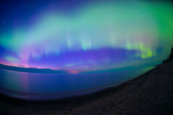
Twilit Aurora, photo by Eric Hackney

Wowzas!!! Here’s the northern lights as seen last night from the Keweenaw Peninsula. Space Weather is saying that there’s a good chance of more strong northern lights tonight!

I’ve written about the science behind the colors on the Northern Lights, but how about some highlights of the beliefs about colors of the aurora from ancient people around the world?

In Bulfinch’s Mythology, Thomas Bulfinch claimed in 1855 that in Norse mythology: The Valkyrior are warlike virgins, mounted upon horses and armed with helmets and spears … When they ride forth on their errand, their armour sheds a strange flickering light, which flashes up over the northern skies, making what men call the “aurora borealis”, or “Northern Lights”.

The Algonquin think the lights are their ancestors dancing around a fire.

The northern lights in Scotland were known as “the mirrie dancers” or na fir-chlis. The dance often ended in a fight – “the mirrie dancers bled each other last night”. The appearance of the lights also predicted bad weather.

In Latvian folklore the aurora borealis, especially if red and observed in winter, are fighting souls of dead warriors especially if it is red and seen in the winter. It is an omen foretelling disaster.

Russian folklore associates the northern lights with the fire dragon (“Ognenniy Zmey”). The dragon came to women to seduce them when their husbands were gone.

The Finns named the northern lights revontulet, or fox fires. According to their legend, foxes made of fire lived in Lapland. And, the fox fires were the sparks they took up into the atmosphere on their tails.

Click for more including photos!

View Eric’s photo bigger and see more in his 9-7-15: Northern Lights V slideshow.

Many more Michigan aurora pics on Michigan in Pictures!

Caribbean of the North

Carribean of the North

Caribbean of the North, photo by Cory Genovese

A while back I featured this as the cover photo on twitter.com/michpics. It’s so great I had to share it here as well! Cory wrote:

A day trip kayak cruise with a couple of friends on Lake Superior resulted in us finding ourselves in the “Caribbean of the North”…albeit with the pool heater unplugged ;)

Indeed! View the photo bigger and see more Lake Superior amazingness from Cory and be sure to follow him at facebook.com/PhotoYoop!

Waterfall Wednesday: Gorge Falls

Gorge Falls Black River Byway

Gorge Falls, photo by Eric Hackney

GoWaterfalling’s page on Gorge Falls says:

A very scenic waterfall set in a very scenic gorge. An added plus is the close proximity of the equally impressive Potawatomi Falls. These are two of the most impressive falls on the Black River and are also the two easiest to access.

Gorge falls is named for the deep and narrow gorge above and below the falls. This was my personal favorite of Black River Scenic Byway waterfalls. It is also one of the easier waterfalls to visit, being only a short distance from the parking area. There are a fair number of stairs to the falls overlook. It is only a short walk upstream to see Potawatomi Falls.

Read on for more including directions to this and other nearby waterfalls along the Black River.

You can check out Eric’s photo bigger and see more in his 6-27-15 Black River Scenic Byway slideshow.

Tons more Michigan waterfalls (including some by Eric!) on Michigan in Pictures.

“A” Shaft at Cliff Shaft Mine Museum

A Shaft at Cliff Shaft Mine Museum, Ishpeming, Mi

“A” Shaft at Cliff Shaft Mine Museum, Ishpeming, Mi., photo by Thom Skelding

The Cliffs Shaft Mine Museum page at Pure Michigan says that the Ishpeming museum is open June – September Tuesdays through Saturdays from 10 am to 4 pm:

Walk back in history to see local historical artifacts representing the local community during the great mining era. View historical displays of miners and mines past and present, headgear & other safety equipment available to miners of yesteryear, and displays on blasting and diamond drilling equipment. Stop in the Ishpeming Rock and Mineral Club’s room and view over 500 minerals from the local area, the Upper Peninsula, Midwest and the world.

Take a guided tour of the tunnels that the miners walked to the base of the C-Shaft and listen to the history of mining from those who worked the mines. Follow up the stairs past old underground iron ore cars with a stop at the blacksmith shop. Go outside to view towers 97’ to 174’ high which were used to lower miners 1250’ into the bowels of the earth. Stand beside a 170-ton Iron Ore Truck with tires 12 feet high.

Don’t forget your camera so you can have a memento of your visit standing inside the 30 ton shovel bucket in front of the Dry building or in front of the 170-ton Iron Ore truck. End your tour in the gift shop to pick up memorabilia of your visit. The museum open with a nominal admission.

Sounds pretty cool to me! Follow the museum on Facebook for the latest (and some old photos).

View Thom’s photo background big and see more in his slideshow.

Lots more Michigan museums and more mining on Michigan in Pictures.

Sea Cave on Superior

Sea Cave by Craig

Sea Cave on Lake Superior, photo by Craig

The Pictured Rocks National Lakeshore geology page says (in part) that:

During the Nipissing “high stand,” Chapel Rock and Miners Castle as well as many less prominent features (such as perched sea caves near Little Beaver Lake Campground) were carved into the Cambrian sandstone by wave action.

Quite the whittling job by Gitche Gumee!

View Craig’s photo bigger on his Facebook page and see more jaw-dropping Lake Superior pics on Craig’s Flickr.

Enjoy your weekend everyone!

Waterfall Wednesday: Ogemaw Falls

Ogemaw Falls Waterfall

Ogemaw Falls (4), photo by David Hedquist

GoWaterfalling relegates Ogemaw Falls to its Minor Waterfalls page, but it looks like a very pretty spot nonetheless!

Ogemaw Falls is a 12 foot drop on Ogemaw Creek in Baraga County Michigan. It is located off of Baraga Plains Road, which intersects with US-41 just a mile or so north of Canyon Falls. Head west for about 1.5 miles. The road will turn to the left, and there will be a large pond to the left. This is where the road crosses Ogemaw Creek. The falls are a few hundred yards to the left. The road crosses above the falls, so you cannot see them from the road. You have to climb down into the gorge to get a view. This is not difficult, but there is no real trail. This is a small waterfall. Many much more impressive waterfalls can be found in Baraga County.

David Hedquist is the author of Waterfalling in Wisconsin and now he’s turning his attention (and camera) on Michigan’s falls. View his photo background big and see more views including closer up and even a video on his Ogemaw Falls slideshow.

Many (many) more Michigan waterfalls can be found on Michigan in Pictures!

Tahquamenon Falls Thursday

Tahquamenon Falls Thursday

Tahquamenon Falls, photo by Charles Bohnam

The Tahquamenon Falls State Park page says:

Tahquamenon Falls State Park encompasses close to 50,000 acres stretching over 13 miles. Most of this is undeveloped woodland without roads, buildings or power lines. The centerpiece of the park, and the very reason for its existence, is the Tahquamenon River with its waterfalls. The Upper Falls is one the largest waterfalls east of the Mississippi. It has a drop of nearly 50 feet and is more than 200 feet across. A maximum flow of more than 50,000 gallons of water per second has been recorded cascading over these falls. Four miles downstream is the Lower Falls, a series of five smaller falls cascading around an island. Although not as dramatic as the Upper Falls, they are equally magnificent. The falls can be viewed from the river bank or from the island, which can be reached by rowboat rented from a park concession. The island walk affords a view of the falls in the south channel.

This is the land of Longfellow’s Hiawatha – “by the rushing Tahquamenaw” Hiawatha built his canoe. Long before the white man set eyes on the river, the abundance of fish in its waters and animals along its shores attracted the Ojibwa Indians, who camped, farmed, fished and trapped along its banks. In the late 1800’s came the lumber barons and the river carried their logs by the millions to the mills. Lumberjacks, who harvested the tall timber, were among the first permanent white settlers in the area.

Rising from springs north of McMillan, the Tahquamenon River drains the watershed of an area of more than 790 square miles. From its source, it meanders 94 miles before emptying into Whitefish Bay. The amber color of the water is caused by tannins leached from the Cedar, Spruce and Hemlock in the swamps drained by the river. The extremely soft water churned by the action of the falls causes the large amounts of foam, which has been the trademark of the Tahquamenon since the days of the voyager.

Click through for maps, photos & more.

View Charles’s photo background bigtacular (really – do it!) and click more of his waterfall photos.

Lots more Tahquamenon Falls on Michigan in Pictures and (just found it) waterfall wallpaper. :)


Waterfall Wednesday: Spray Falls

Spray Falls in the Pictured Rocks

Spray Falls, photo by David Juckett

Go Waterfalling’s page on Spray Falls begins:

Spray Falls is the remotest, and perhaps the most impressive of the several waterfalls in Pictured Rocks National Lakeshore. The 70′ waterfall plunges over the cliffs at Pictured Rocks and lands directly in Lake Superior.

The falls is right on the edge of the cliffs, and the creek has not cut back into the cliffs at all, so it is impossible to view the falls from the front unless you are on the water. The cliffs are sheer for miles in both directions, so there is no way to get near the base of the falls without a watercraft. Lake Superior is too cold for swimming. :)

The Lakeshore Trail passes right over the top of the falls, and you can get right to the brink of the falls. Be careful because the cliffs are undercut and unsafe in many places. About 1/4 mile east of the falls there is a safe lookout point from which you can get a nice, but distant, side view of the falls. There is a sign marking the lookout.

Read on for more including tips on hiking in and photos from the top. You can get views like this on the Pictured Rocks Cruises.

View David’s photo background bigtacular and jump into his slideshow for more great views of the Pictured Rocks!

More summer wallpaper and more Michigan waterfalls on Michigan in Pictures.

Fayette State Park

Fayette State Park

Fayette State Park, photo by Mike Boburka

The Michigan Historical Center’s page on the Fayette Historic Townsite says:

The Fayette Historic Townsite includes 20 historic buildings, exhibits, a walking tour and scenic overlooks. Fayette has 20 preserved buildings and structures. Eleven buildings house museum exhibits and are open to the public, including the hotel, machine shop, company office, town hall, and residences.

A massive blast furnace still stands on the site, and is part of the well-preserved history of this former 19th century industrial site. Fayette is a living museum, telling the story of a company town in the 19th century, nestled on the Garden Peninsula in the central Upper Peninsula.

The limestone bluffs on Snail Shell Harbor were mined for use in the blast furnaces.
Exhibit with clothing and toys, part of the children’s exhibit at Fayette Historic Townsite.
Exhibits at Fayette focus on life in a company town, including what it was like to grow up there. At its height, half the population of Fayette was children.

The townsite is part of Fayette Historic State Park and on the second Saturday of August the annual Heritage Day celebrates Fayette with period displays, food, and music. Click through for more.

View Mike’s photo background big and click for more of Mike’s Fayette photos.

More Michigan ghost towns on Michigan in Pictures.