Angry waters across Michigan

There used to be a bridge here by Nate

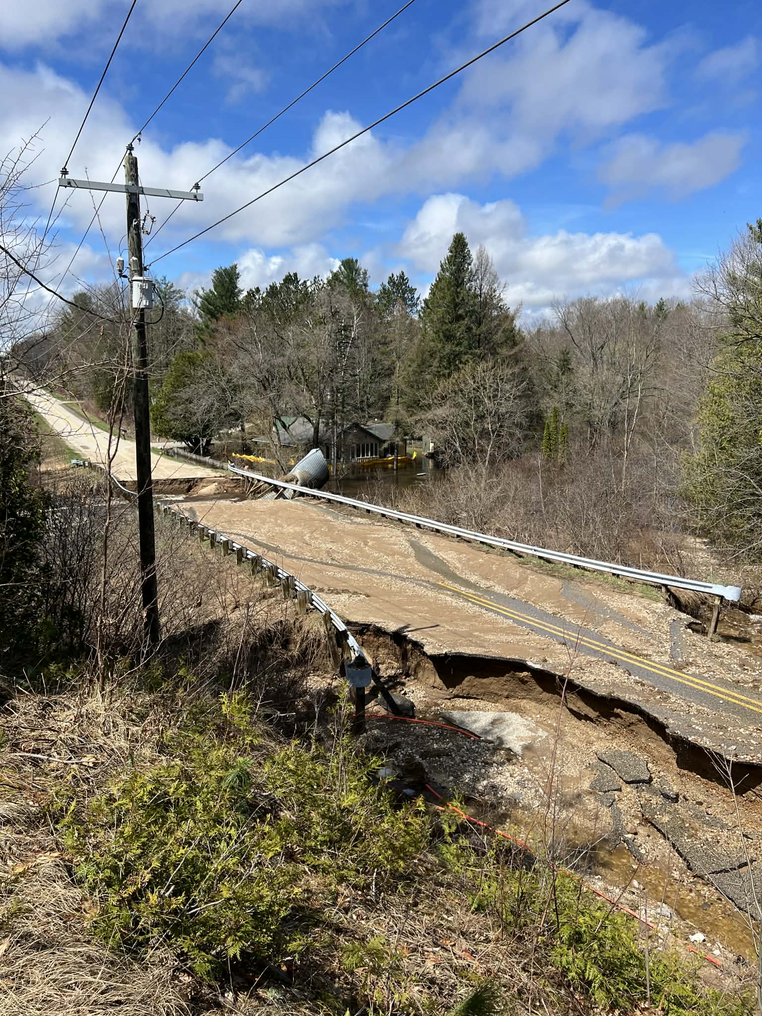
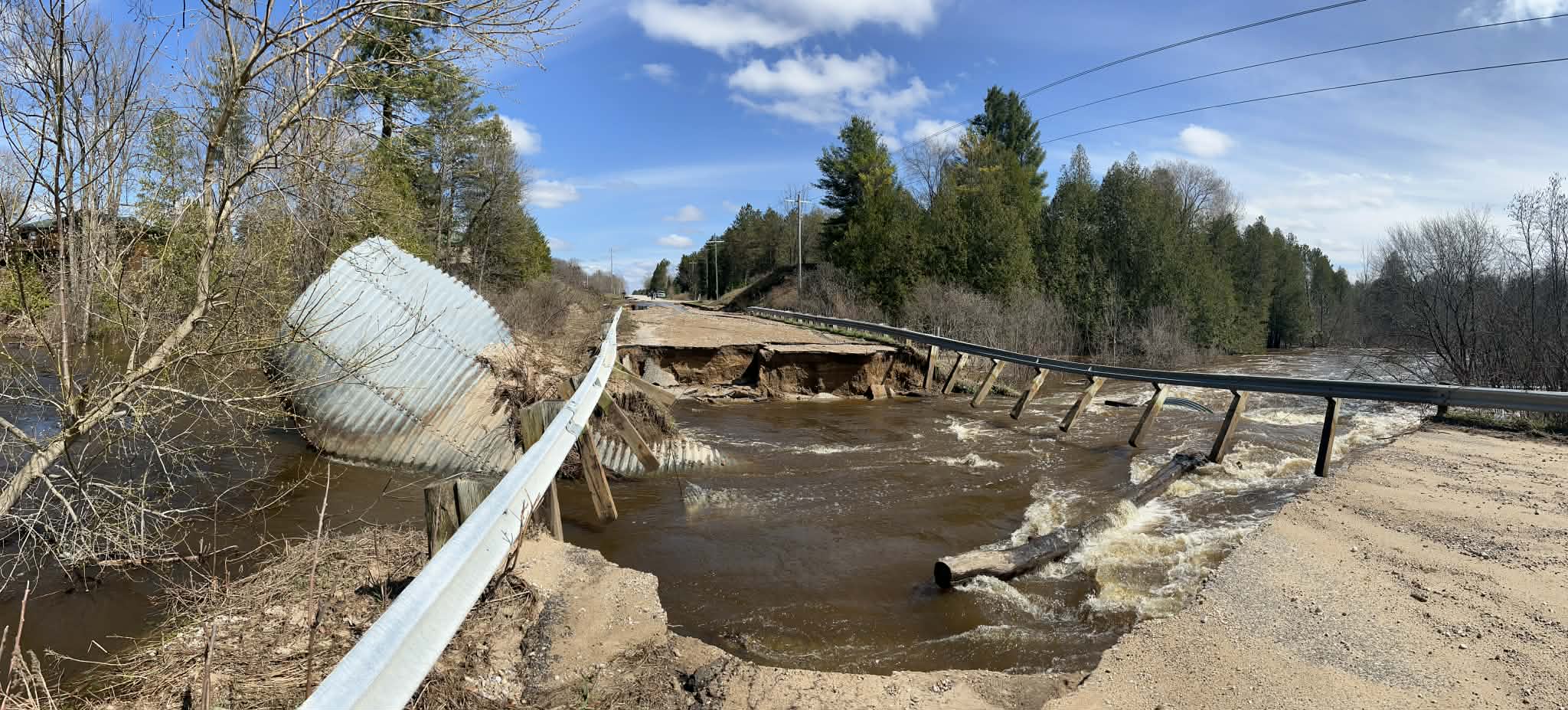
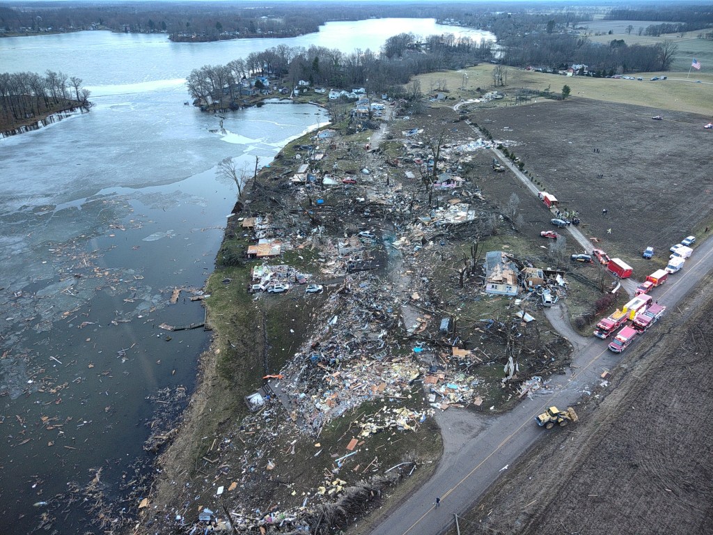
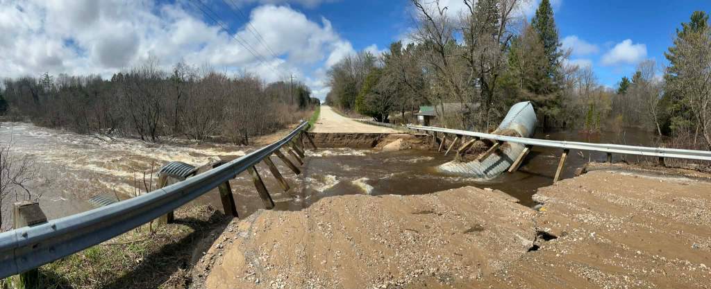
There used to be a bridge here by Nate Griswold

The state of Michigan has been absolutely pummeled by severe weather over the last week, and it’s taking a serious & unprecedented toll on our roads & bridges as demonstrated in the photos my friend Nate shared with me from Johnson Rd near Kaleva.

Just a few of the impacted areas include the pictured damage near Kaleva, flooding in Frankenmuth, Traverse City’s Boardman River bridging its banks & taking out bridges (for sure check out the 40 photos+ of the damage by Madi Taylor), a washout on the M-119 “Tunnel of Trees”, flooding along the Muskegon River, worries at dams including Mio Dam, significant damage across southeast Michigan including Ann Arbor & Metro Detroit, and an evacuation order in Cheboygan due to concerns about the Cheboygan Dam failing discussed yesterday. I could go on and on, but I’m just going to share hopes that everyone can stay safe and look in on their neighbors!!

CBS Detroit has an overview of the concerns and how a historic late winter snowstorm combined with an extremely rapid warmup & heavy spring rains to create this perfect storm of terrible outcomes.

Support Michigan in Pictures with Patreon

Is it Spring in Michigan? That depends on where you live…

Melting by smiles7

Melting by smiles7

mLive’s Mark Torregrossa shares that Michigan’s northern & southern halves will have completely different temperature patterns this week (see the NOAA temperature graphic for Thursday below):

For southern Michigan, we have three spring-like days and four almost-wintry days. For northern Michigan, we have a slight taste of spring temperatures Tuesday and Wednesday, with the rest of the days more like winter. It looks much warmer in the first week of April.

Julie took this shot of the Mighty Mac back in April of 2021. Here’s a photo of the ice at Tahquamenon Falls breaking free that she shared 10 years ago plus a shot of a classic spring skiing slush pond from the other day. Follow her on Flickr for the latest!

Support Michigan in Pictures with Patreon

Friday Tornadoes devastate Southwest Michigan

Union Lake tornado damage by MSP Emergency Management & Homeland Security Division

Union Lake tornado damage by MSP Emergency Management & Homeland Security Division

Fox 2 Detroit reports that the National Weather Service has confirmed that three separate tornadoes ripped through southwestern Michigan Friday night:

A lone supercell developed in La Porte County, Indiana, that moved up into Cass, St Joseph, and Branch counties in Michigan, where the death and destruction happened. Four people have died, including a 12-year-old boy in Cass County, and three people in Union City. Penni Jo Guthrie was identified as one of the three Union City victims. The other two have not been identified publicly yet.

The National Weather Service confirmed a tornado had touched down in Union City. An EF-3 tornado with winds reaching at least 150mph has been confirmed according to their initial assessment. An EF-2 tornado was confirmed to have touched down in Three Rivers, and a third tornado was confirmed in the Edwardsburg area, but no rating was assigned to it as of Saturday evening.

Governor Whitmer activated the State Emergency Operations Center Friday night & you can head over to their Facebook for some Michigan State Police Drone overflight videos.

Disasters are always magnets for scams, so it’s important to research who’s asking and where it’s going. The good people over at Michigan Storm Chasers are sharing great info on their Facebook & have created an Amazon Wish List for relief efforts that I encourage you to consider. If you want to include something for the four legged homies who are also hit hard by disaster, the Humane Society of Southwest Michigan is a good option.

Here’s a video of the tornado that caused the damage in the photo above. There’s something extra terrifying about seeing a tornado across a frozen lake.

Support Michigan in Pictures with Patreon

Thundersnow Season

thundersnow aftermath by Christian Collins

thundersnow aftermath by Christian Collins

A reader commented that they had seen lightning & heard the rumble of thunder yesterday, an observation shared by numerous folks around the state. Although a lot of the online articles are hyping up thunder snow as a dangerous or abnormal phenomenon, it’s not.

The NOAA National Severe Storms Laboratory’s Severe Weather 101 explains that although thunderstorms are less common in the winter, sometimes lightning does occur within a snowstorms and is called thundersnow. Thundersnow can be found where there is relatively strong instability and abundant moisture above the surface, such as above a warm front. Thundersnow is sometimes observed downstream of the Great Salt Lake and the Great Lakes during lake-effect snowstorms too.

Christian took this back in February if 2017. See more in his barns – graneros gallery on Flickr.

PS: If anyone in the Upper Peninsula captured yesterday’s thundersnow on video, the National Weather Service Marquette Office would love to see it!

Support Michigan in Pictures with Patreon

Wacky Weather Warning

Cold as Ice by Tom Hughes

Cold as Ice by Tom Hughes

mLive’s Mark Torregrossa says that although states can have wacky temperature patterns in the heart of a storm system, Michigan is the only place we can mix those storm system temperatures with our mitten and our powerful lakes! Mark shares that warm air will move in from the south while an easterly and northeasterly wind will funnel frigid air from ice-covered Lake Huron over Northern Lower Michigan:

Somewhere around Saginaw, Bay City, Clare and Traverse City, we could have a big shock going from temperatures in the 50s to temperatures near freezing.

Imagine going from Ann Arbor to Bay City to visit family Wednesday afternoon. You open the door in Ann Arbor to see what it’s like outside. It’s a common ritual at this time of year. It’s very nice. It’s 61 degrees, which right now feels like a spring dream. So you put on a light jacket and start driving north. You get out of your car in Bay City, and you freeze.

Definitely a day to keep an eye on the updated forecast!!

Tom captured this ice covered beauty in Utica way back in 2015. See more in his Winter gallery on Flickr!

Support Michigan in Pictures with Patreon

Rain & possible “flash freeze” today in Michigan!

Winter Water Drops by Superior Seasons

Winter Water Drops by Superior Seasons

The folks at Michigan Storm Chasers share a detailed statewide Michigan weather forecast every morning that you should definitely incorporate into your daily feed. On Facebook they share that although we will see temps above freezing for most of the state, even topping 50 degrees in southern Michigan, temps will drop later in the day, potentially precipitously in what is known as a “flash freeze”. A flash freeze happens when rain has fallen, completely stopped, and then shortly afterward air temperatures drop from the 40s or 50s down into the 20s or colder. Ryan explains is all in their excellent video.

Michael shared this photo 13 years & one day ago on December 17, 2012, remarking that it was strange to see rain in December in the UP. Here are a couple more he shared to our Absolute Michigan group on Flickr, and you can see more in his The UP Eh! gallery.

Support Michigan in Pictures with Patreon

Triple Dip Polar Vortex coming for Michigan

Shark Attack - Triple X by Jill N. Hamilton-Krawczyk

Shark Attack – Triple X by Jill N. Hamilton-Krawczyk

Accuweather shares that much of the US and definitely Michigan is facing a rare “triple dip” polar vortex:

“This Arctic air outbreak can be attributed to a displacement of the polar vortex,” AccuWeather Lead Long-Range Meteorologist Paul Pastelok said. “The outbreak this week will be the first of probably three such rounds with it. Another cold blast is likely next week and a third the week after that,” Pastelok explained. “The waves of Arctic air will lead to significant surges in energy demands.”

I originally shared this photo way back on April 1, 2010 along with a pretty funny spoof, and I am very happy to bring it back along with several more that Jill shared from The Heidelberg Project in Detroit, a truly astonishing work of activist art. See many more in her excellent Detroit gallery on Flickr & stay warm people!!

Support Michigan in Pictures with Patreon

Michigan Fall Color: Double Rainbow Edition

Fall Color Tour in Northern Michigan Rainbow edition by James Eye View Photography

Fall Color Tour in Northern Michigan Rainbow edition by James Eye View Photography

mLive’s Mark Torregrossa shares that if you think there’s more rainbows out there than usual, you are correct! He explains the science behind Michigan’s rainbow bonanza:

To have rainbows, we need rain and sun at the same time. What weather pattern is classic for rain and sun at the same time? The current lake-effect rain shower situation is perfect for rainbows. The rain showers are small, maybe only five miles wide. There is a lot of clear sky around the rain showers.

…So we know why we have had and currently have a lot of rainbows in Michigan in the past few days- the spotty lake-effect showers combined with sunshine. But why have there been numerous double rainbows? It has to do with the angle of the sun, combined with the daily weather pattern.

For a double rainbow, the sun has to be fairly low on the horizon, lower than 40 degrees above the horizon. It just so happens the lake-effect showers reach their peak intensity and coverage during the late afternoon heating of the day, when the sun is low on the horizon.

James took these last Friday on the Sleeping Bear Dunes National Lakeshore. You can follow him on Facebook & Instagram. For sure visit his website to view & purchase his work including 2025 Photo Calendars.

Wildly enough, I featured Double Rainbow Sunrise from James last year – he clearly has a next level knack for rainbows!!

Support Michigan in Pictures with Patreon

What lies beneath might be a shipwreck

The Great Lakes Shipwreck Aurora by Bob Gudas

The Great Lakes Shipwreck Aurora by Bob Gudas

Janelle D. James of Bridge Magazine wrote last week that Michigan is facing the worst drought in over a decade. Although we’ve gotten some much needed rain with more on the way, the Michigan Storm Chasers share that it probably won’t be enough to make a significant difference. Rather than bum you out with ways that drought sucks, let’s focus on this cool photo & story from when drought was even worse!

When Bob shared this photo in October of 2012 he wrote, “The remains of the Great Lakes steamer Aurora. The wreck recently became visible due to record low waters in Lake Michigan basin. The 300 foot wooden steamer was built in 1887 and burned to the waterline at this spot in 1932. The stern was subsequently covered with water where it remained until the drought of 2012. Approximately 2 weeks ago the water receded off of the wreck. This view shows approximately 200 feet of the wreck with another 100 feet being buried under a sand dune.

A Shipwreck World article on the Aurora add that the Aurora was significant as one of the last great wooden steamships: When launched by the Murphy and Miller of Cleveland on August 23, 1887, the 290-foot, steam-driven propeller was the largest and most powerfully built wooden vessel on the Great Lakes. The 3000-ton vessel was initially owned by John Corrigan of the Aurora Mining Company of Milwaukee which paid $150,000 for its construction. It was used to ship iron ore from the Gogebic Range Ironwood, Michigan, to Cleveland and coal from Cleveland on the return trip.

View & purchase Bob’s work on his website, and check out a seasonally appropriate pic in Autumn’s Rainbow: the colors of fall on Michigan in Pictures!

Support Michigan in Pictures with Patreon

Sunset on a steamy summer

Steaming into Sunset by Diann*

Steaming into Sunset by Diann

Summer is pretty much in the books, and Fox 2 Detroit shares that Summer 2025 was a hot one for a unique reason that bodes poorly for our future:

Because the summer of 2025 is not over, it’s not included in the rankings. But as of Aug. 14, the average daily temperature is 74.3 degrees – making it one of the hottest.

Here’s the difference: this year’s overnight lows have been some of the highest ever. The region has dealt with multi-day periods of sustained heat unlike any other year.

When people talk about how hot it was back in 88, they’re right to do so,” FOX 2’s meteorologist Derek Kevra said. “But what they got was some relief days. We have had very few relief days this year.”

In the summer of 1988, there were seven days when overnight lows fell into the 40s and 26 days with overnight lows in the 50s. The summer this year has had barely any nights when temperatures fell that low. That included a 150-hour stretch where temperatures didn’t even fall below 70 degrees. Over the entire month of July, only three days have fallen into the 50s.

This isn’t the first time I’ve shared Diann’s photo of the coal powered SS Badger steaming out of its home port of Ludington back on Labor Day 2008 & it won’t be the last! Here are a few others that I’ve featured over the years – see more in her Third Coast gallery on Flickr.

More Michigan-focused climate change posts on Michigan in Pictures.

Support Michigan in Pictures with Patreon