When you think about it, it’s not only miraculous that the white pine on Chapel Rock in the Pictured Rocks National Lakeshore survives with barely any soil, but also that it endures winter after winter in the teeth of Lake Superior.
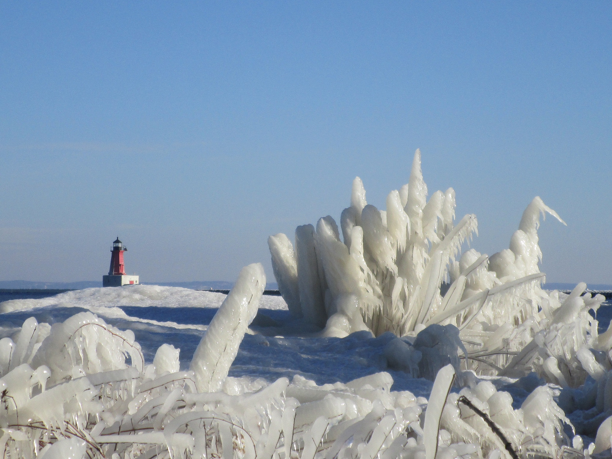
As with water, this color is caused by the absorption of both red and yellow light (leaving light at the blue end of the visible light spectrum). The absorption spectrum of ice is similar to that of water, except that hydrogen bonding causes all peaks to shift to lower energy – making the color greener. This effect is augmented by scattering within snow, which causes the light to travel an indirect path, providing more opportunity for absorption. From the surface, snow and ice present a uniformly white face. This is because almost all of the visible light striking the snow or ice surface is reflected back, without any preference for a single color within the visible spectrum.
The situation is different for light that is not reflected, but penetrates or is transmitted into the snow. As this light travels into the snow or ice, the ice grains scatter a large amount of light. If the light is to travel over any distance it must survive many such scattering events. In other words, it must keep scattering and not be absorbed. We usually see the light coming back from the near surface layers (less than 1 cm) after it has been scattered or bounced off other snow grains only a few times, and it still appears white.
In simplest of terms, think of the ice or snow layer as a filter. If it is only a centimeter thick, all the light makes it through; if it is a meter thick, mostly blue light makes it through. This is similar to the way coffee often appears light when poured, but much darker when it is in a cup.
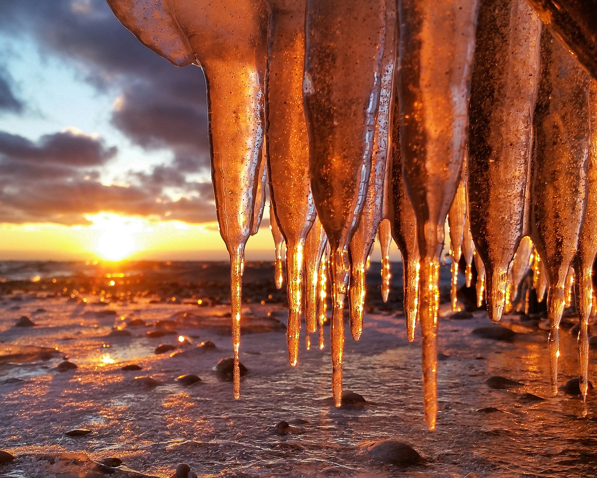
Charles took this photo last March off Gills Pier on the Leelanau Peninsula when there was a whole lot more ice than there is this winter. View it background bigilicious and see more in his Leelanau Peninsula slideshow.
The website Michigan History was produced by someone at MSU. While I have no idea who or why they gave up on what was shaping up to be a cool website, the history checks out. The page on Port Huron’s Blue Water Bridge says:
Perhaps Port Huron’s greatest claim to fame is the Blue Water Bridge, a historic arcing bridge that serves as a means of transportation between Canada and the United States. The bridge is located over the St. Clair River, and connects Port Huron, Michigan, to Sarnia, Ontario. In 2013 the Blue Water Bridge celebrated its 75th anniversary, and a closer look at its history show why Port Huron residents take pride in the structure.
The original Blue Water Bridge was constructed in 1938, and was built by the American Bridge Company of New York, and the Hamilton Bridge Company of Ontario. The original bridge is an arch cantilever bridge, which was designed to not only support large amounts of traffic, but also to have an aesthetic arching look. In the late 1980s the border crossing became so popular that plans for a new bridge were brought up. However, instead of demolishing the old bridge, a new one was built in 1997 beside the old bridge, to support eastbound traffic.
The Michigan cost for building the new bridge, and renovating the old one was $62.6 million dollars. (Michigan Department of Transportation) The project was considered an enormous success and won awards from the American Society of Civil Engineers, the Ontario Institution of Steel Construction, and the Federal Highway Administration. For Port Huron residents the bridge signifies the close connection with Canada, and the willingness of the two sides to work closely together.
There’s more Michigan bridges on Michigan in Pictures, and since you’ve read this far, Boatnerd’s page on the Saginaw has everything you’ll want to know about the self-unloading bulk carrier that was launched May 9th, 1953 as the John J. Boland. It’s one of three near sister vessels built by this shipyard: The John G. Munson which is still plying the lakes and the Detroit Edison that suffered a career-ending grounding in Lake Michigan in December of 1980.
“Lives are snowflakes – unique in detail, forming patterns we have seen before, but as like one another as peas in a pod (and have you ever looked at peas in a pod? I mean, really looked at them? There’s not a chance you’d mistake one for another, after a minute’s close inspection.)” ― Neil Gaiman, American Gods
The shape of snowflakes is influenced by the temperature and humidity of the atmosphere. Snowflakes form in the atmosphere when cold water droplets freeze onto dust particles. Depending on the temperature and humidity of the air where the snowflakes form, the resulting ice crystals will grow into a myriad of different shapes.
…Kenneth Libbrecht, Professor of Physics at the California Institute of Technology, has made extensive observations of how water molecules get incorporated into snow crystals. In his research, he has observed that the most intricate snowflake patterns are formed when there is moisture in the air. Snowflakes produced in drier conditions tend to have simpler shapes.
Temperature also has a large effect on the formation of snowflakes according to Libbrecht’s research. Snowflakes formed in temperatures below – 22 degrees Celsius (- 7.6 degrees Fahrenheit) consist primarily of simple crystal plates and columns whereas snowflakes with extensive branching patterns are formed in warmer temperatures.
Bottom line: Temperature and humidity influence snowflake formation. The most intricate snowflake patterns are typically formed during warm and wet conditions.
Shawn writes that she can totally relate to this snowflake’s imperfect life. View it background big on Facebook, check out more including a kickin’ video of the Northern Lights at the Mackinac Bridge on her Lake Superior Photo page, and view and purchase photos from LakeSuperiorPhoto.com.
“Being Beer City USA has definitely helped out our business. We got a lot more tourist people than we did the first year. It’s unbelievable how many people you start talking to and they’re from out of town. ~Eric Karns, Elk Brewing
The year 2015 was a record-breaking year for tourism across West Michigan, which means more money into the local economy.
In 2014, 113 million visitors to Michigan generated $37.8 billion dollars — and tourism supported 326,000 jobs in the state. Now, newly released numbers show that 2015 was an even better year for attracting visitors to places like Grand Rapids and the Lakeshore.
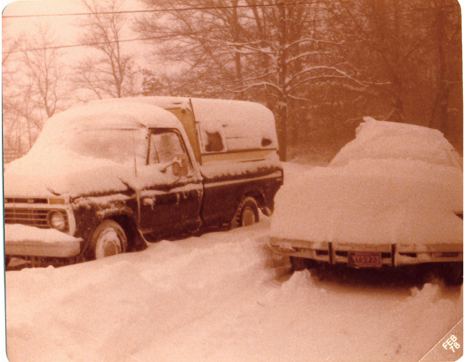
The most extensive and very nearly the most severe blizzard in Michigan history raged January 26, 1978 and into part of Friday January 27. About 20 people died as a direct or indirect result of the storm, most due to heart attacks or traffic accidents. At least one person died of exposure in a stranded automobile. Many were hospitalized for exposure, mostly from homes that lost power and heat. About 100,000 cars were abandoned on Michigan highways, most of them in the southeast part of the state. ~C. R. Snider, National Weather Service Meteorologist in Ann Arbor, Michigan
Today is Michigan’s 179th birthday, but it’s also the anniversary of one of the most significant storms to ever hit the state, the Great Blizzard of 1978. William Deedler’s article A Great Storm is Upon Michigan says in part:
While there are several contenders for the worst blizzard ever to hit the Great Lakes in relatively modern times (since 1870 when records began in Detroit), the immense and intense Blizzard of January 26-27th 1978 must rank at or near the top along with the Great White Hurricane of 1913(my link) with its similar track and powerfulness.
…As the Arctic air circulated throughout the storm while it made its way over Lake Huron, the lowest pressure was reached around 950 millibars or a hurricane-like 28.05 inches! “A Great Storm is Upon Michigan” read the headline of the 800 AM EST Special Weather Statement issued by the National Weather Service Forecast Office in Ann Arbor that Thursday /26th/ morning. Heavy snow and blizzard conditions were extensive as wind gusts in excess of 35 mph whipped the snow into huge drifts across much of Southeast Lower Michigan. Other areas of Eastern Michigan, Indiana and Ohio reported near hurricane-force winds, heavy snow and temperatures hovering between zero and 10 above, resulting in extreme blizzard conditions. These conditions later expanded further east into Pennsylvania and West Virginia and prevailed into the night (26-27th) across much of the Eastern Great Lakes, Southern Ontario and the Upper Ohio Valley. With the storm generating copious amounts of snow and very strong winds, whiteout conditions were widespread. All land and air traffic came to a stand still in the affected regions. Several major roads were closed for at least two to three days, if not longer, while clean up got underway. Numerous NWS employees were stranded at work, home, or on the road somewhere between the two. Several employees worked double shifts into at least Friday (some longer) because of the impassable roads with others simply unable to get to work.
The Blizzard Warnings were allowed to die across Michigan during the forenoon hours of Friday, the 27th. Record 24 hour snowfall totals from the storm included, 16.1 inches at Grand Rapids, 15.4 inches at Houghton Lake and 12.2 at Dayton, OH. Snowfalls for the entire storm (25-27th) included a whopping 30.0 inches at Muskegon (some of which was Lake Michigan enhanced), 19.3 inches at Lansing and 19.2 at Grand Rapids. Snowfalls were less over Southeast Lower Michigan (mainly because of the rain that fell for a period) and included 9.9 inches at Flint and 8.2 inches at Detroit.
I’ll never miss a chance to tout Terry Pepper’s Seeing the Light as one of the premier resources for information about Michigan’s lighthouses, as well as others on the Great Lakes. He packs them full of the history including the political maneuverings and economic reasons for lighthouse development and closure and peppers in (sorry – couldn’t resist) historical photos and pictures from his own visits.
The entry on the Menominee North Pier Light details the lumber boom that led to the construction of the first lighthouse in 1877 and the development of the iron ore rich Menominee Range. He continues:
The town of Menominee continued to reap the benefits of the Range, and as a result significant harbor improvements were undertaken in the 1920’s, At their completion in 1927, a prefabricated octagonal cast iron tower was delivered by vessel, and lowered onto the pier.
The thirty-four foot tower was painted white, and integrated with an attached fog signal building. An elevated wooden catwalk stretched along the wooden pier to provide the keepers with safe access to the light during periods when waves crashed across the surface of the pier. The octagonal cast iron lantern room was outfitted with a Fourth Order Fresnel lens of unknown manufacture.
At some point thereafter, the wooden pier was replaced by a concrete structure with a forty-foot diameter circular crib at its offshore end. At this time, the fog signal was eliminated with the inclusion of an automated electrically operated signal in the tower. With automation of the light in 1972, the need for daily maintenance of the light was also eliminated, and the iron catwalk was removed from the pier.
The tower was painted bright red, and relocated to a white painted concrete platform in the center of the crib. Its elevated position on the pier provided a focal plane of forty-six feet.
While the catwalk no longer snakes its way along the pier, the iron tower still stands guard over the harbor entrance, its jewel-like Fresnel lens replaced by a stark modern 300mm plastic lens.
As you may know, 2016 is my 11th year of making Michigan in Pictures. I really love doing it and am certainly going to keep it up as long as I am able. It does take a bunch of my time that might otherwise be spent working or getting out to see some of Michigan’s beauty, so I’ve been looking for a way to subsidize it that doesn’t involve ads, paywalls, or other annoyances.
Yesterday, I was reading a blog and saw they had a button to support them using a web service called Patreon. I checked it out, and it basically allows readers to become patrons of blogs they enjoy. Seemed like a great idea to me so I have set it up. If you’d like to donate a buck or more a month, I would very much appreciate it! Click here for my Patreon donations.
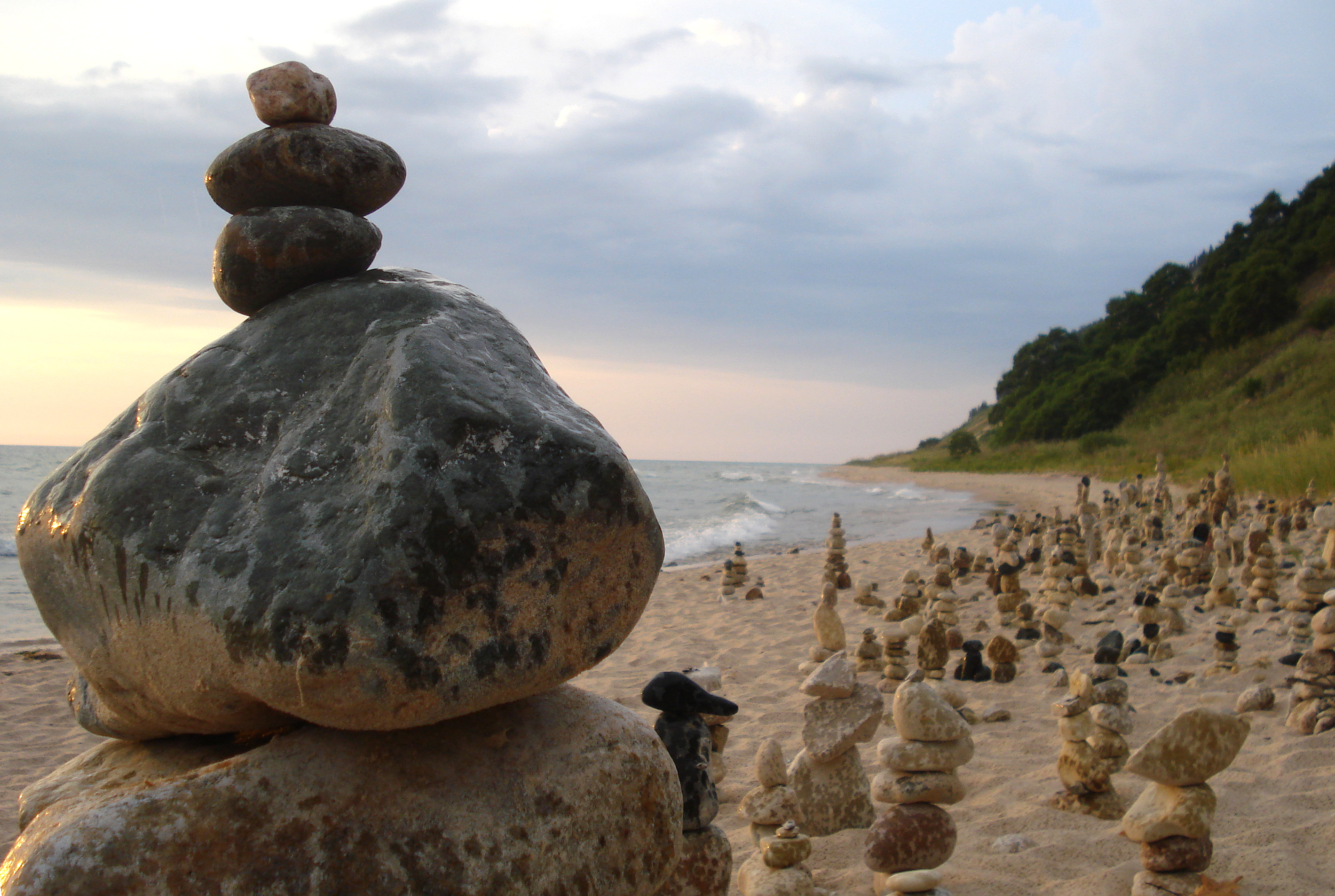
OK, on to today’s photo. Back in August of 2007, I was out walking with my friend Ken Lake on Frankfort beach. About a mile north of town we rounded a point and came upon a wondrous site – hundreds of balanced rock sculptures comprised of thousands of rocks. It remains one of the coolest works of art I’ve ever seen, and also a total mystery. I’ve still never heard who built these or why.