The great blue herons in Michigan are largely migratory, with almost all leaving the state during the winter months. Most leave by end of October and return in early to mid-March.
The great blue heron is mostly a colonial nester, occasionally they nest in single pairs. Colonies are typically found in lowland swamps, islands, upland hardwoods and forests adjacent to lakes, ponds and rivers. Nests are usually in trees and may be as high as 98 ft. (30 m) or more from the ground. The platform like nests are constructed out of medium-sized sticks and materials may be added throughout the nesting cycle. Nests are usually lined with finer twigs, leaves, grass, pine needles, moss, reeds, or dry gras. The same nests are refurbished and used year after year.
Most great blue herons return to southern Michigan heronries in mid-March although a few may remain through the winter if there are areas of open water. Courtship and nest building commences from early April in southern Michigan to early May in the extreme northern portions of the state. Both sexes are involved in the nest building process with males primarily gathering sticks from the ground, nearby trees, or ungarded nearby nests.
Luck is believing you’re lucky. ~Tennessee Williams
My St. Patrick’s Day wishes are that my Michigan State Spartans prove they should have been a #1 seed all along (Go Green!), that the Michigan Wolverines show they’re not the only ballers in the Great Lakes State by defeating Notre Dame (Go Blue!), and that luck makes itself a believable part of your life (Go Luck!!).
Danielle writes “This little guy was having a hard time keeping his hat on – my best shot was a little blurry so had to resort to this one.” View photo bigger than a leprechaun and see more in her Motor City slideshow.
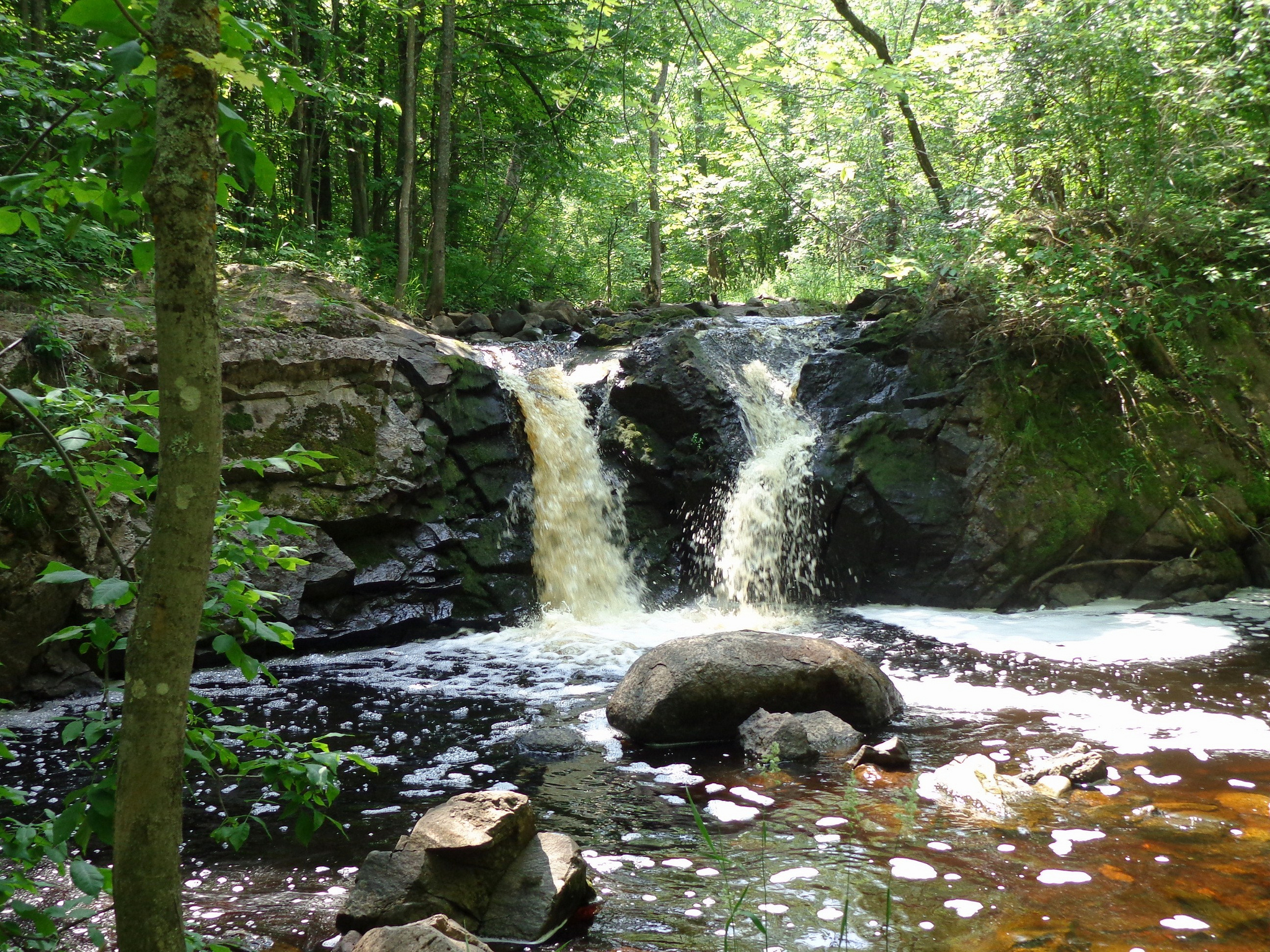
When I come across a waterfall photo that I can’t place, I have three places I turn:
GoWaterfalling.com – hands down the best resource for waterfalls of Michigan and the Great Lakes region (with a few others scattered in for good effect). The author delivers concise descriptions, photos of the falls and accurate directions with maps and tips for hundreds of waterfalls.
Waterfalls of the Keweenaw – this site was created by Jacob Emerick and has information, directions and beautiful photos for 200 Michigan waterfalls, in the Keweenaw and beyond. Sorry for getting Jacob’s name wrong!!
I have my ideas as to which waterfall this is – any guesses? Post them in the comments!
Paula took this last April on the Keweenaw when spring snowmelt in the U.P. pumps the waterfalls up to incredible levels. View her photo background big and see more including some crazy ice-climbing shots in her slideshow.
The State of Michigan has 83 counties, and since I got a number of comments asking for more about our communities, I’ll try and profile them all … sooner or later. Here’s some information via Wikipedia about Kalkaska County, Michigan:
The first settler in Kalkaska County was an Englishman named William Copeland, who purchased land in the northwest corner of the county in 1855. The county was set off in 1840 and called Wabasee until 1843. The name Kalkaska is thought to be a Chippewa word meaning flat or burned-over country. An alternative theory is that this is a neologism or neonym created by Henry Schoolcraft, originally spelled Calcasca. Some theorists suggest this is word play. Schoolcraft’s family name had been Calcraft, and the Ks may have been added to make the name appear more like a Native American word.
Logging was the first important industry. The discovery of substantial deposits of oil and natural gas resulted in the construction of a processing plant by Shell Oil Company in 1973 and a major economic boom in the community.
Kalkaska Sand, the state soil of Michigan, was named after the county because of the large amounts deposited in the area from the glaciers in the Ice Age. Kalkaska County has over 80 lakes and 275 miles of streams and rivers. Much of the county is marshland. County elevation ranges from 595 feet (181 m) to about 1,246 feet. This makes it one of the more uneven counties in the Lower Peninsula.
The Pere Marquette State Forest covers much of the county. Glaciers shaped the area, creating a unique regional ecosystem. A large portion of the area is the so-called Grayling outwash plain, which consists of broad outwash plain including sandy ice-disintegration ridges; jack pine barrens, some white pine-red pine forest, and northern hardwood forest. Large lakes were created by glacial action.
“With abundant snow cover yet and temperatures around 65 F, fog forms in almost white out conditions near large snow fields! This can lead to near zero visibility in a matter of seconds and makes for some amazing photographs!”
My post on Tuesday generated a little controversy because I stated who I was supporting in Michigan’s primary and also that I’d continue to share my personal opinions here on Michigan in Pictures. Most readers who commented agreed, including Jim Schaefer who shared the most powerful comment I’ve ever read on my work:
Dear Farlane…I’m so glad you posted item #4 today along with the great photo. I had to move to Sheboygan, WI in 2014 for health reasons, leaving behind 45-yrs of life in Flint, MI. I’ve been saving your photos and their accompanying stories on a daily basis for several years now in their own special folder on my laptop. They are my daily reminder about all of the good things about Michigan that some Michigan residents seem to take for granted.
Unfortunately, some of these same people have conveniently forgotten about your 1st Amendment rights to editorialize on your own website. Shame on them! I am also a 72-yr old Army veteran who served a 13-month tour in a combat zone in Korea in 1966. That’s why I’m so glad that you reminded people to vote today. I was drafted against my will back in 1966 but I served my country and did my job over there and I’ll be damned if I’m going to let anyone take away my right to vote. So you keep right on posting all of those great photos along with the Michigan history behind them.
May God bless you always…Jim Schaefer
God bless you too Jim, and here’s something for your desktop folder from Flint! The Charles Stewart Mott Foundation shares this about their founder:
Charles Stewart Mott
Charles Stewart Mott established the C.S. Mott Foundation in 1926, in response to his deep concern about the welfare of Flint, Mich., as well as his abiding affection for his adopted community.
An automotive pioneer, Mr. Mott was an original partner in the creation of the General Motors Corporation, founded in Flint in 1908. As one of the city’s leading industrialists, Mr. Mott was elected mayor, serving three terms (1912–13, 1918) during periods of overwhelming and turbulent growth in the city. As mayor he was responsible for instituting fair property assessments, orderly accounting audits, health and safety ordinances, building codes and a house numbering system.
Read more about Mott in Autos not Apples. Here’s a few facts about the 16-story Art Deco building that bears his name and houses the Mott Foundation:
Flint’s first skyscraper with a total height of 226 feet to the top of the passenger elevator penthouse.
Designed by Smith, Hunchman & Grylls (SmithGroup) the oldest practicing architectural firm in the US.
Construction took one year to complete at a cost of approximately $2,000,000.
Original design included seven retail stores on the first floor. There were also originally men’s rooms on every floor, but women’s restrooms only on every other floor.
The Freight elevator is still operated with the vintage 1930 controls.
Building name was changed to the Mott Foundation Building on January 1, 1945.
One of the coolest things for me about making Michigan in Pictures is when I come across something in Michigan that there’s little to no information about online.
Such is the case with Root Beer Falls (map), a roughly 8′ waterfall that is located a couple of miles north of Wakefield in Gogebic County. “Rootbeer Falls” is also a name for the Tahquamenon Falls, and one would assume that the same tannins that give Tahquamenon their rich, brown color are at work here.
Douglas Feltman posted this sweet time-lapse video from Root Beer Falls last fall, saying that this small drop on Planter Creek is fed by overflow from Sunday Lake in Wakefield, just a quick walk through the woods from Wertanen Road. He has 49 more Michigan waterfall videos as well!
The photographer, David Hedquist, is the author of Waterfalling in Wisconsin and has told me he’s working on a Michigan book, so stay tuned! Sorry- I misremembered. David is NOT working on a new book. He did share that Phil Stagg of Waterfalls of Michiganis writing books though!
I featured this photo yesterday in Five Things you need to know about Michigan on Absolute Michigan. Check the link out for more interesting things including some new revelations about when Gov. Snyder’s senior staff raised concerns about Flint’s water (October 2014) and a look at an innovative approach to tackling urban blight.
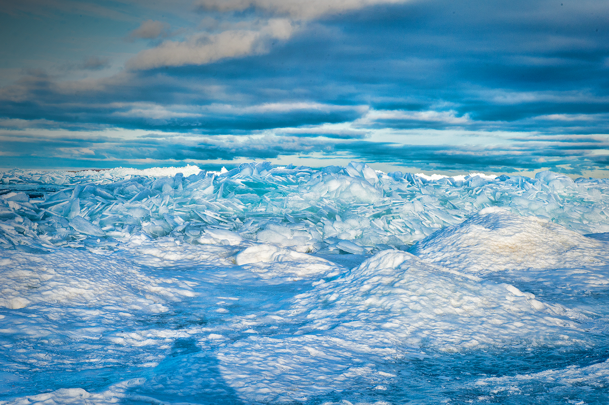
As with water, this color is caused by the absorption of both red and yellow light (leaving light at the blue end of the visible light spectrum). The absorption spectrum of ice is similar to that of water, except that hydrogen bonding causes all peaks to shift to lower energy – making the color greener.
…In simplest of terms, think of the ice or snow layer as a filter. If it is only a centimeter thick, all the light makes it through; if it is a meter thick, mostly blue light makes it through. This is similar to the way coffee often appears light when poured, but much darker when it is in a cup.
Leap years are added to the calendar to keep it working properly. The 365 days of the annual calendar are meant to match up with the solar year. A solar year is the time it takes the Earth to complete its orbit around the Sun — about one year. But the actual time it takes for the Earth to travel around the Sun is in fact a little longer than that—about 365 ¼ days (365 days, 5 hours, 48 minutes, and 46 seconds, to be precise). So the calendar and the solar year don’t completely match—the calendar year is a touch shorter than the solar year.
It may not seem like much of a difference, but after a few years those extra quarter days in the solar year begin to add up. After four years, for example, the four extra quarter days would make the calendar fall behind the solar year by about a day. Over the course of a century, the difference between the solar year and the calendar year would become 25 days! Instead of summer beginning in June, for example, it wouldn’t start until nearly a month later, in July. As every kid looking forward to summer vacation knows—calendar or no calendar—that’s way too late! So every four years a leap day is added to the calendar to allow it to catch up to the solar year.
Todd took this shot back in August of 2009 at one of my favorite spots for hiking (and jumping) – the Pyramid Point overlook in the Sleeping Bear Dunes National Lakeshore. Lake Michigan is hundreds of feet down a steep bluff from the point where she’s jumping, and many is the person who wished they didn’t run down that bluff after toiling up it!
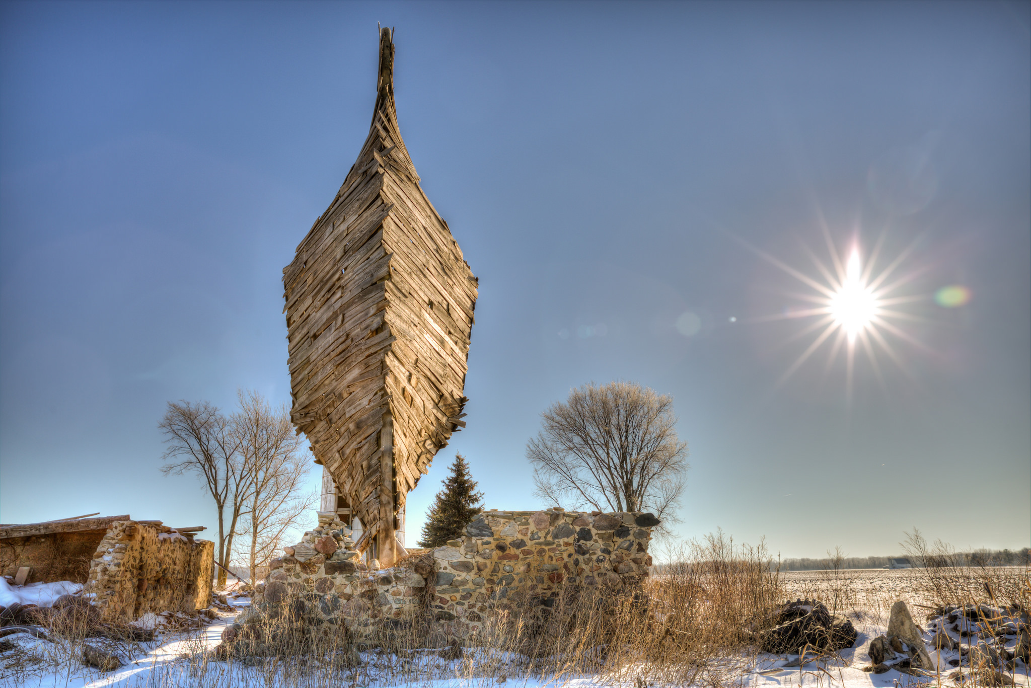
The Celestial Ship of the North (Emergency Ark), aka the Barnboat, is a site-specific installation and permanent sculpture in Port Austin, Michigan created by Scott Hocking. He wrote to me:
I was asked by Detroiter Jim Boyle, whose family is still in Port Austin, if I’d ever had any ideas of working with old barns. He’s been trying to get a Detroit / Port Austin connection going by bringing artists up there to do projects. I basically told him I’d had some fleeting thoughts about how much certain barns look like overturned ship hulls, and that if I had an old barn to work with, I’d probably turn it into a boat.
So, that was the beginning.
Like all of my work, I try to let the materials and site dictate what I make, and as I worked on the barnboat the shape became what it is now – mostly influenced by the intense winds of Michigan’s thumb. It took about 3 months total, but I’m not quite done yet: I’m still planning to fill in the base with mounded sand this spring for a little extra stability, and so that it can once again overgrow like that ivy covered barn it was made from.
Awesome. Check out lots more of Scott’s engaging work on his website.
Another day, another mass shooting – this time in Kalamazoo, Michigan. Beyond right and left, can we all agree that we need to figure out why we’re the only nation in the world who has this tragic problem and work on actually addressing this problem?
I’m guessing bolstering our gutted mental health system is a great place to start.