

Here’s hoping that Hurricane Irene spares folks her worst…
Check this out bigger and in Kai’s Late August Ann Arbor Storm slideshow.
Check out the latest storm photos from the Absolute Michigan pool too!
Here’s hoping that Hurricane Irene spares folks her worst…
Check this out bigger and in Kai’s Late August Ann Arbor Storm slideshow.
Check out the latest storm photos from the Absolute Michigan pool too!
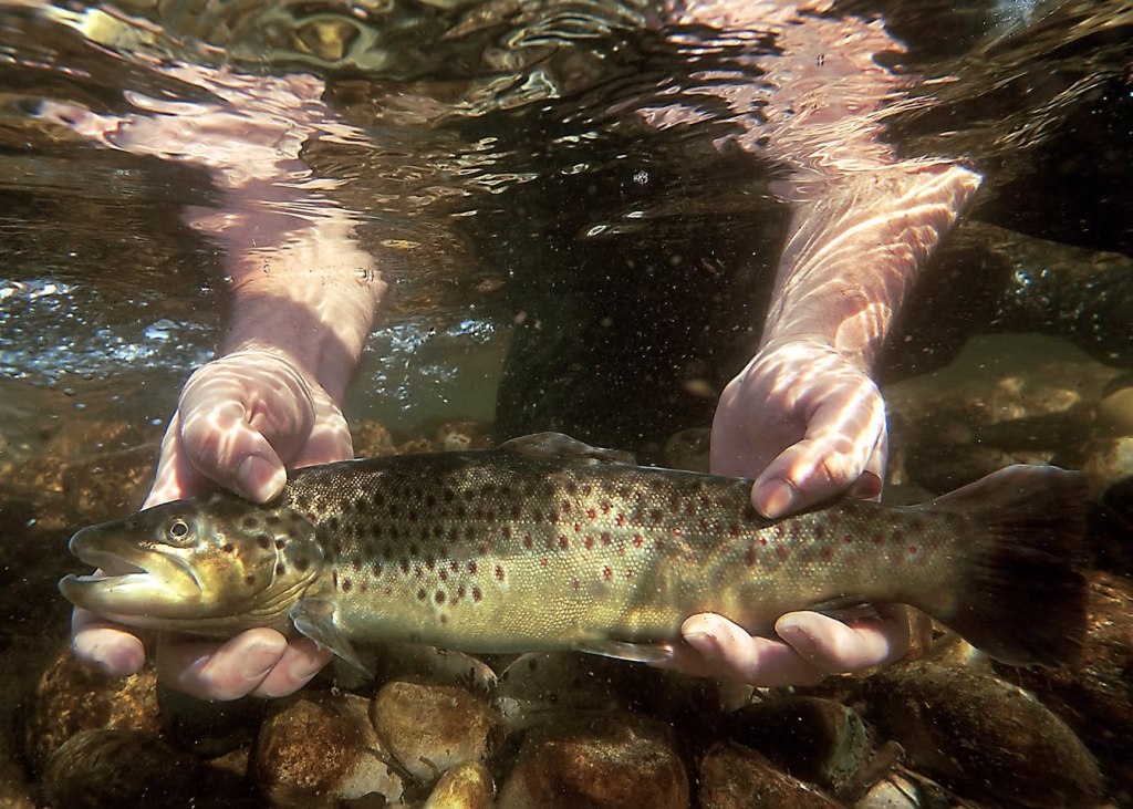
Brook Trout by Michigan DNR
Michigan’s state fish is the Brook Trout (Salvelinus fontinalis). The Michigan DNR says:
Brook trout have a long, streamlined body with a large mouth that extends past the eye. Color variations include olive, blue-gray, or black above with a silvery white belly and wormlike markings (vermiculations) along the back. They have red spots sometimes surrounded by bluish halos on their sides. The lower fins have a white front edge with black and the remainder being reddish orange. The tail fin is square or rarely slightly forked. During breeding time in the fall male brook trout can become very bright orange-red along the sides.
The brook trout is native to Michigan’s waters and is the state fish of Michigan. They can be found throughout most of the state in many creeks, streams, rivers, lakes, and in the Great Lakes. Brook trout require cool, clear, spring-fed streams and pools. They can be found under cover of rocks, logs, and undercut banks and have been described as stationary. Larger brook trout often inhabit deep pools moving to shallow water only to feed. They prefer temperatures from 57–60 degrees F.
…Brook trout have been described as voracious feeders with the potential to consume large numbers of zooplankton, crustaceans, worms, fish, terrestrial insects, and aquatic insects. Ephemeroptera, Trichoptera, and Diptera often make up a large component of their diet. However, they will often feed on whatever is most readily available. Brook trout are avidly sought after by sport anglers, for food as well as for the sport. They can be caught by using various bait and lures including worms, crickets, grasshoppers, wet and dry flies, spoons, and spinners.
Trout Unlimited’s Brook Trout Atlas adds: Brook trout are the only trout native to much of the eastern United States and serve as indicators of the health of the watersheds they inhabit. Strong wild brook trout populations demonstrate that stream or river ecosystem is healthy and that water quality is excellent. A decline in brook trout populations can serve as an early warning that the health of an entire aquatic system is at risk.
Choose your own adventure with more Michigan state symbols and more fish & fishing on Michigan in Pictures.


O Kun de Kun Falls, photo by Splash of Sunset Photography
Go Waterfalling says that O Kun de Kun Falls
O Kun de Kun Falls is one of the largest of the waterfalls in Ontanagon county. It is not as large as Bond Falls or Agate Falls, but it is just as scenic and far wilder. It is a mile plus hike to O Kun de Kun Falls and there are no fences or signs. The waterfall is also unusual in that it is an actual plunge falls. Only a handful of the many waterfalls around Lake Superior are plunge falls. You can go behind the falls if you want, but you need to be careful and sure footed.
The trail head to the falls is located on the east side of US 45 about 8 miles north of Bruce Crossing. There are signs for the parking area. The trail to the falls is part of the North Country Trail. It is a 1.3 mile fairly level hike to the falls. Before you reach the main falls you will reach a smaller 10′ plunge upstream. Keep going! The first time I tried to visit O Kun de Kun I stopped at the upper falls, thinking I had reached my destination. The real falls is just a short distance downstream. The trail crosses a suspension bridge below the falls. If you have not gone far enough to see the bridge, keep going.
If you’re wondering about the name of the falls, it was after a famous chief. If you’re wondering about the title of this post, Pasty.com explains:
The name “Ontonagon” is derived from the Ojibway word “nontounagon,” which means “I lost my bowl.” Local legend surrounding the name stems from the story that a member of Chief O-Kun-De-Kun’s band was washing bowls near the mouth of the river when she was startled by an unkempt stranger in a canoe. The woman inadvertently dropped one of the bowls into the river and exclaimed “nontounagon”. The white man took her declaration to be a reply to his question about the name of the area.
Check this out bigger and in Matthew’s great Waterfalls of the Western UP album.
Learn about Bond Falls, Agate Falls abd more Michigan Waterfalls on Michigan in Pictures!

Zug Island, photo by Airplane Lane.
Over on Absolute Michigan a little while back we had a feature from one of my favorite blogs, Bootstrap Analysis. It’s titled Urban Birding: Touring the Rouge River. For a look at what the Rouge looks like and a sense of how that happened, click over!
If you’re interested in the preservation efforts on the river, check out Friends of the Rouge River.
Check it out background bigtacular and in Matt’s awesome Aerial Photography slideshow.
Lots more Michigan aerial photographs on Michigan in Pictures.

Wikipedia relates that the Elk River Chain of Lakes is a seventy-five mile-long series of fourteen lakes and interconnecting rivers in Antrim, Charlevoix, Grand Traverse and Kalkaska Counties forming a single waterway.
The chain of lakes system begins with the upper stage of the Intermediate River, which rises in hill country at 45°00′20″N 85°04′45″W in the northwest corner of Chestonia Township in central Antrim County. From here, the waterway traverses a number of small lakes flowing north, then making a sharp turn near the village of Ellsworth, flows south through a narrow valley, paralleling the tracks of the Pere Marquette Railroad, until emptying into Intermediate Lake. The outlet of Intermediate Lake converges with the Cedar River in the village of Bellaire, gaining considerable volume. Now a river of substantial flow, it continues south into 1,700-acre (6.9 km2) Lake Bellaire. Leaving the lake, the stream becomes the Grass River, winding for some two miles (3 km) through the scenic Grass River Natural Area before emptying into Clam Lake. Clam Lake in turn empties directly into Torch Lake. At over 18,000 acres (73 km2) in size, Torch Lake is the largest body of water in the system.
The waterway, now clarified after traversing the immense depths of the lake, continues south through the Torch River, joins with the Rapid River, a major tributary, and empties into Lake Skegemog, a 2,500-acre (10 km2) lake that is studded with large stump fields, the result of the flooding of timberlands when the lake level was raised several feet by the construction of the dam at the terminus of the system. Lake Skegemog, which is the meeting point of Grand Traverse, Kalkaska and Antrim counties, is conjoined at its western end to 7,700-acre (31 km2) Elk Lake, the second-largest and final lake in the system. The outflow of Elk Lake, the Elk River, flows a short distance to a power dam in the town of Elk Rapids, then out into the east arm of the Grand Traverse Bay of Lake Michigan at 44°54′06″N 85°24′49″WCoordinates: 44°54′06″N 85°24′49″W. For most of its length, “The Chain” is navigable by small boat, broken up only by a dam in Bellaire. Larger boats are able to navigate between Elk Rapids and Torch Lake.
Click here to follow the Chain of Lakes on Google Earth. I was only able to get from Grand Traverse Bay up to Intermediate Lake – if anyone knows of a better map, let me know. Here is (roughly) where Ron took the photo above Torch Lake looking up the Torch River to Lake Bellaire and here is where Google Maps says the Chain starts. Don from Up North Memories has an old postcard with some of the lakes labeled.
Ron took these in late April of 2010 – it’s a must see slideshow with some great early moring views of mist on the lakes and even some cherry blossoms.

Agate Falls 1939 and Agate Falls, photo by Marty Hogan
Dear Everybody
having a swell time
tried a different lake today and caught some nice bass.
-Nick
Marty posted this postcard of Agate Falls that Nick mailed at 1pm on the 14th of July,1939 to Kenosha along with a modern-day look. No word on if Nick’s last name was Adams. ;)
GoWaterfalling.com says that Agate Falls is a pretty waterfall that is relatively easy to get to on your way to or from Bond Falls. They write:
Agate Falls is a Michigan State Scenic Site 6.5 miles east of Bruce Crossing on MI-28. There is a roadside park (Joseph F. Oravec roadside park) just past the bridge over the Ontonagon River. Unfortunately the provided trails and overlooks are somewhat limited. With some effort you can scramble down to the river to get some very good views of the falls, which seems to be popular with local fishermen, or scramble up the river banks to get to the old railroad bridge over the falls. The bridge is now part of a snowmobile trail.
Marty’s Agate Falls slideshow has several more photos including the roadside sign.
Also see Michigan Wild & Scenic Rivers: Ontonagon River on Michigan in Pictures.

Upper Bond Falls, photo by James Marvin Phelps.
It is hereby declared to be the policy of the United States that certain selected rivers of the Nation which, with their immediate environments, possess outstandingly remarkable scenic, recreational, geologic, fish and wildlife, historic, cultural or other similar values, shall be preserved in free-flowing condition, and that they and their immediate environments shall be protected for the benefit and enjoyment of present and future generations. The Congress declares that the established national policy of dams and other construction at appropriate sections of the rivers of the United States needs to be complemented by a policy that would preserve other selected rivers or sections thereof in their free-flowing condition to protect the water quality of such rivers and to fulfill other vital national conservation purposes.
~Wild & Scenic Rivers Act, October 2, 1968
Michigan has 16 nationally designated Wild & Scenic Rivers. Since Field & Stream tapped Michigan #1 for flyfishing in the USA, I thought it would be cool to profile these unique rivers & streams. We’ll start with the Ontonagon River. The Our Favorites page at upflyfishing.com says:
The Ontonagon River, along with its four branches and tributaries drains an enormous area of the western Upper Peninsula in Ontonagon, southwest Houghton and northern Gogebic Counties. The system offers a wide diversity of opportunities for wading, canoeing, shoreline, and even boat anglers. Much of the flow is through wild, scenic country. Several beautiful waterfalls and whitewater rapids appear along its journey.
…A 12 mile stretch of the East Branch (from Lower Dam Falls to Sparrow Rapids has been designated as a Michigan Blue Ribbon Trout Stream. The Middle Branch supports a good population of resident Brown, Rainbow, and Brook Trout. Access is fairly good with sections flowing along the Ottawa National Forest. A few anglers tube or canoe and the river is wide enough to permit flyfishing in most stretches. Overall, the Middle Branch supports the best trout fishing on the Ontonagon and the village of Watersmeet is in the heart of several of these great fishing areas. Down stream from Agate Falls, the river becomes receptive to anadromous fish, and anglers enjoy an extended fishing season. Expect good Steeelheading in spring, with browns up to 6 pounds and salmon showing up in the fall. Some Brook trout also frequent the river here.
FYI, Bond Falls are on the Middle Branch. Check this out background big and in James’ Bond Falls slideshow.

The Detroit Studio Collective is holding their Grand Opening this Saturday (May 7) from noon to 10 PM (location). The photographers (some of whom have been featured on Michigan in Pictures) are Bobby Alcott, Rebecca Gutierrez, Kellie Saunders, Rob Terwilliger, Josh Willerton and Eric Peoples.
Check Eric’s photo out bigger and in his Greatest Hits slideshow.

“Bond Falls In Spring, photo by siskokid
More about Bond Falls on the Ontonagon River from Michigan in Pictures!
Check this out bigger and in Jim’s waterfall slideshow!

The Belle Isle Bridge | Detroit, MI, photo by .brianday..
Wikipedia notes that the official name of the bridge across the Detroit River to Belle Isle from Detroit is the MacArthur Bridge. The bridge uses nineteen arches to span the 2,193 feet to Belle Isle. Completed in 1923 for $2,635,000, it replaced a mostly wooden bridge that was destroyed by fire in 1915. See The day the bridge to Belle Isle burned down for more on that. While it was once known as the Belle Isle Bridge, was renamed in honor of General Douglas MacArthur in 1942.
Belle Isle Bridge “Douglas MacArthur Bridge” at HistoricBridges.org explains:
This is an extremely long multi-span concrete arch bridge that gives people access to Belle Isle, and the structure is the longest arch bridge in the state of Michigan.
This bridge is extremely significant not only because of its length, but because it is a very early example of a cantilevered concrete arch. A cantilevered concrete arch does not function like a traditional arch. Traditional arch bridges require the arch to be a complete and connected arch to function. This arch bridge does not function in that way. Each half of each arch spans is a cantilever arm that is structurally independent from the other half of the arch in that span. Standing under a span of this bridge, a clear gap at the center of the span is visible. Indeed, on the outermost part of the arch, a decorative “keystone” was placed for aesthetic reasons to cover up this gap.
Wayne County Road Commission was among Michigan’s counties, an innovative and creative road commission and they apparently made significant use of concrete cantilever arch structures. Other examples of concrete cantilever bridges in the county remain. These other examples are different from the Belle Isle Bridge, and feature a third central “suspended” span between the cantilever arms.
Check it out bigger and in Brian’s Long Exposure slideshow.
