Spider SZN

Spider & Web by David Marvin

Spider & Web by David Marvin

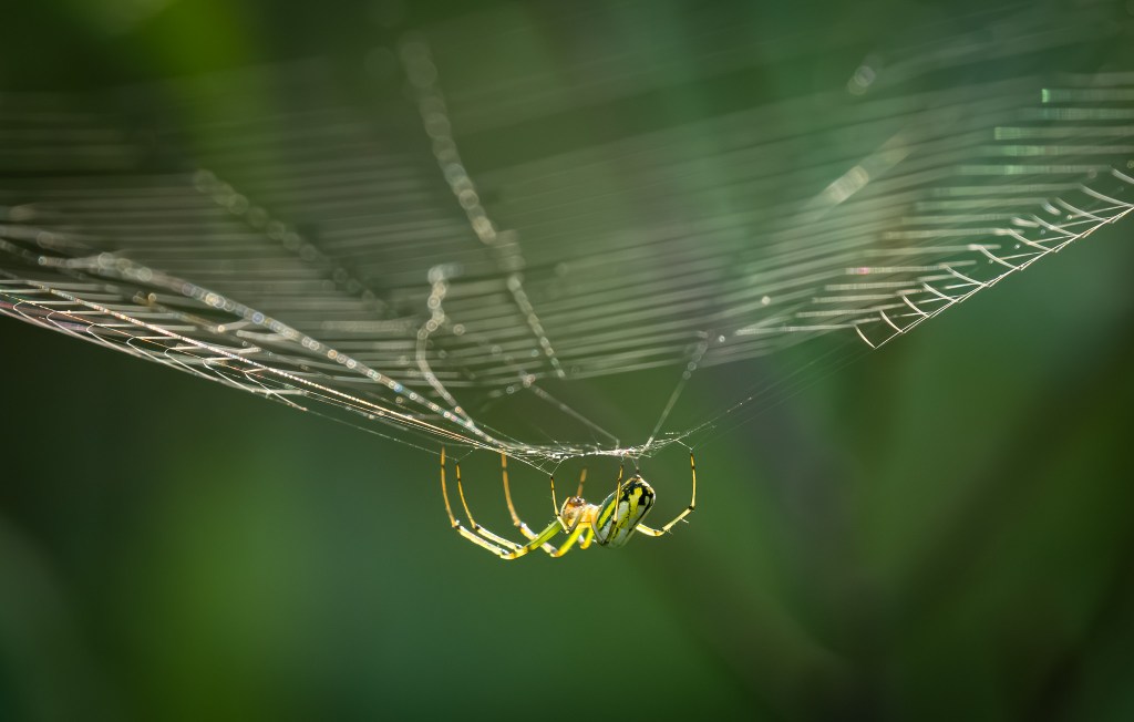
Click On Detroit shares the reason we’re seeing a lot of spiders and webs in Michigan right now:

…Most spiders’ breeding seasons coincide with the transition from summer to fall. If you see more spiders than usual around your home during these months, chances are they’re mature males wandering far and wide in search of a mate. In fact, less than 5 percent (yikes) of the spiders you encounter inside your home have set one of their eight feet outside, according to Rod Crawford, Curator of Arachnids at the Burke Museum at the University of Washington.

Unlike humans, spiders are considered cold-blooded creatures since they don’t have a mechanism to regulate body temperature. When it’s cold, some spider species go through a process of cold-hardening to survive the winter. Beyond the chemical transformation in their bodies, many spiders seek shelter in piles of rocks, leaves or wood. Once snuggled up, spiders enter a slowdown state called diapause. In diapause, spiders are not completely inactive. Instead, they may emerge on warmer days to hunt and feed on any insect prey that may be active during this time.

So that’s fun 😉

David shot this in July – check out his latest on Flickr!

Support Michigan in Pictures with Patreon

Slow Burn Sunset

Slow Burn Sunset in Muskegon by Walter E. Elliott

mLive meteorologist Mark Torregrossa shares that a large plume of wildfire smoke will be impacting our weather (and sunsets) over the weekend:

While it looks like a dry weekend that should be sunny, there will likely be areas of high-level wildfire smoke. The exact timing of the smoke will be difficult. It does look like some time Saturday will have a thick blanket of smoke high in the sky. It won’t mean much to the big picture of the weather other than keeping our temperatures out of the high-80s.

One thing is sure this weekend. Our humidity will be fairly low. We can see that with the morning low temperatures. Saturday morning we will drop into the 50s.

I think I can live with that forecast!!

Walter took this photo last Saturday. Follow his Facebook for more and view & purchase his work on his website.

Support Michigan in Pictures with Patreon

Hurricane Beryl bringing a different rainstorm to Michigan

Another Angry Sky by Jeremy Vohwinkle

Another Angry Sky by Jeremy Vohwinkle

Beryl is the earliest category 5 hurricane since we classifying them 100 years ago & a pretty clear indication that climate change continues apace. Since we’ve all probably formed an opinion on that which can’t be changed, how about some other science? mLive meteorologist Mark Torrregrossa shares that the storms in Michigan due to Hurricane Beryl are NOT your ordinary rainstorms:

Tropical rain such as the heavy rain we are having tonight and Wednesday originates from a different part of the globe compared to most all other rains in Michigan. The rain now has some moisture in it from Africa, the Atlantic Ocean, the Gulf of Mexico and the deep southern states of the U.S. Most of our rain has moisture gathered from the air over the Pacific Ocean or the western and central United States.

…. The tropical clouds typically have a lower base, sometimes only one thousand to two thousand feet above the ground. You may feel like you can reach up and touch the clouds. Our ordinary rains would have a low base at five thousand feet and many bases are higher than five thousand feet.

…Now think about the different things that can be in a raindrop from Africa and the tropics. I haven’t seen any actual research on this but tropical rains can carry more and different nutrients within the drop. I call this rain, “the great green-up.” Look at your grass. Look at your vegetable and flower garden after the rain. If it’s not drowned out, your garden with go through robust growth this week. It will be like you fertilized it. It’s about to get nature’s “Miracle-Gro.”

Lots more in this fascinating article!

Jeremy took this way back in the summer of 2011 in Edwardsburg, way down in southwest Michigan. See more in his Landscapes gallery on Flickr & stay dry!!

Support Michigan in Pictures with Patreon

Double Rainbow Sunrise

Rainbows Over Lake Michigan by James Eye View Photography

Atmospheric Optics is the go-to for information about rainbows and other marvelous sights in sky. They explain the science behing double rainbows:

Light can be reflected more than once inside a raindrop. Rays escaping after two reflections make a secondary bow.

The secondary has a radius of 51º and lies some 9º outside the primary bow. It is broader, 1.8X the width of the primary, and its colours are reversed so that the reds of the two bows always face one another. The secondary has 43% of the total brightness of the primary but its surface brightness is lower than that because its light is spread over its greater angular extent. The primary and secondary are are concentric, sharing the antisolar point for a center.

James got some great shots of a double rainbow at sunrise over Lake Michigan in Empire yesterday morning. See more by clicking the pic. and view & purchase his work on his website.

Support Michigan in Pictures with Patreon

May 7, 2024 Kalamazoo Tornado

Kalamazoo Tornado by Lori Higgins

Early last night, the Kalamazoo/Portage area was rocked by tornadoes:

The storms rolled through around 6 p.m. and 7 p.m., causing thousands to lose power. Some of the heaviest damage was concentrated around Westnedge Avenue, Centre Avenue and Oakland Drive, according to Portage city officials.

The FedEx building at 6701 Portage Road sustained a direct hit from one of the reported tornadoes. The roof of the building caved in, leaving the interior exposed. After the storm passed, 50 employees were trapped inside as crews worked to remove dangerous wires so rescue efforts could commence. First responders eventually helped them all out of the building, Tuesday night.

Another spot with major damage was Pavilion Estates Mobile Home Park, 6830 East N Ave. in Pavilion Township, just east of Portage. About 17 of the homes were totally demolished and 173 had some degree of damage, according to the Kalamazoo County Sheriff’s Office.

Click through for more from mLive. Lori’s photo was shared far & wide including by Michigan Native Photography who shared a bunch of photos (by other photographers) of the damage. Stay safe everyone and LISTEN to the weather forecasters when they tell you to beware. Turns out they can be right a lot of the time!!

More Michigan tornados on Michigan in Pictures.

Support Michigan in Pictures with Patreon

That Summertime Vibe…

Summertime by Charles Bonham

Summertime by Charles Bonham

This pic of a kid deep in his vibes in Leland’s Fishtown from a decade ago is one of my all-time favorite photos. It’s also kind of perfect for news from mLive meteorologist Mark Torregrossa that Michigan (well southern Michigan at least) might hit 70 degrees multiple times next week! Mark offers the caveat that the problem with temperature forecasts in Michigan in April & May is that even light north winds can work with Lake Michigan or Huron to push cold air down the lake. Pretty cool article – check it out at mLive.

See more in Charles’s Funky Photos and/or Leland/MI Fishtown galleries on Flickr!

Support Michigan in Pictures with Patreon

Warm Wet Winter on tap for Michigan

Water Street During an Ice Storm by Mike McManaman

Water Street During an Ice Storm by Mike McManaman

The National Oceanic & Atmospheric Administration (NOAA) has issued their 2021-2022 winter weather outlook for the US. The NOAA Winter Outlook covers December 2021 through February 2022 and notes that with the La Nina weather pattern, Michigan & the Great Lakes are expected to see warmer & wetter than average conditions. Head over to NOAA for more including weather maps.

Mike took this photo on Flint’s Water Street after an ice storm back on Christmas Eve 2014. See more in his Flint, Michigan gallery on Flickr. 

Support Michigan in Pictures with Patreon

Riders on the Great Lakes Storm

via leelanau.com…

Riders on the Storm by Mark Smith

Riders on the Storm by Mark Smith

Here’s a simply stunning shot by Mark Smith of a stormfront rolling over the Manitou Islands. Follow Mark on Instagram @downstreamer7 for more & view & purchase his work at Leelanau Landscapes Photography.

Support Michigan in Pictures with Patreon

November 2020 Heatwave

Last night at a lake near you by Gary Syrba

Last night at a lake near you by Gary Syrba

If you live in Michigan, you probably enjoyed a pretty nice weekend! WOOD-TV Grand Rapids reports that record highs fell in Kalamazoo (75°), Grand Rapids (74°), Lansing (75°) and Muskegon (74°). The other locations on the map don’t have record data. Click on Detroit adds that Detroit toppled the previous November 7th record of 70 from 2016 with a high of 71. Daily records were also set at Traverse City (76°), Pellston (73°) and Gaylord (71°). 

Gary took this photo at Grand Haven. No word as to whether or not their high of 76 was a record, but guessing it was close! Head over to Gary’s Flickr for more! 


Support Michigan in Pictures with Patreon

La Niña is coming for a winter visit

Ice Cave Sunset by Heather Higham

Ice Cave Sunset by Heather Higham

mLive reports that a La Niña weather system has officially developed & is likely to continue through winter:

La Niña is when the equatorial Pacific waters turn cooler than normal. If the cooler than normal water continues into the northern hemisphere winter, there can be some alteration to normal jetstream patterns.

…an average jetstream position south of Michigan with the center of an upper-level through over the Great Lakes brings an area of wetter than normal conditions to the Ohio Valley and southern Great Lakes. This area of wetter weather includes the southern part of Michigan.

So in looking at the general effects of La Niña on Michigan’s winter, we have in the past leaned toward colder than normal with some increase in snow amounts.

…Lower Michigan as averaging four to 12 inches above normal on snowfall during La Niña winters. The western half of the U.P. also shows a slightly above normal snowfall pattern during La Niña. The lake-effect snowbelts of northwest and southwest Lower don’t show an increase in snow, but do show normal amounts. Normal amounts of snow in the snowbelts is plenty of snow for snow-lovers.

More at mLive.

Heather took this shot of an ice formation on Lake Michigan at Elk Rapids back in January of 2015. See more in her ice formations gallery & definitely follow Heather on Facebook & @SnapHappyMichigan on Instagram!

More ice caves on Michigan in Pictures! <–trust me – some more awesome pics there!

Support Michigan in Pictures with Patreon