Going for the gold

SUP'rs ... going for the 'gold'

SUP’rs … going for the ‘gold’, photo by Ken Scott

It’s hard to believe that Summer 2013 is almost in the books. I hope you’ve had fun and that you get a chance to grab a little more “summer gold” this weekend!!

Check this out bigger and see more in Ken’s Benzie slideshow.

Big Sable Point from 2,000 feet

Big Sable Point from 2,000 feet

Big Sable Point from 2,000 feet, photo by Innerspacealien

The Detroit Free Press recently had a fun article by Ziati Meyer titled Michigan Lighthouse Trivia that related:

LIGHT AFTER DARKNESS: The deaths of 48 people in one year prompted the building of the Big Sable Point Lighthouse. The stretch of water between Big Sable Point and Ludington saw 12 shipwrecks in 1855, so Congress was asked to send money to help. The result — after a Civil War delay — was a $35,000 lighthouse to help ships navigate that area of Lake Michigan

Read on for more fun facts and definitely check out Terry Pepper’s Seeing the Light and our Michigan in Pictures archive for more info and photos of this iconic light north of Ludington.

Check this out background bigtacular and see some more aerial views of the area in Craig’s slideshow.

More great aerial photos on Michigan in Pictures.

SUP Yo?! Stand-up Paddleboarding at the TC Waterman

SUP Yo?!

SUP Yo?!, photo by Rudy Malmquist

I’ve been doing a lot of stand-up paddleboarding this summer on Grand Traverse Bay courtesy my friend Michael who owns The River of Traverse City. I have been pleasantly surprised at how much fun it is and also what a great workout it is.

In a couple of weeks Traverse City will host the TC Waterman. It takes place on Saturday, August 17th and is the largest paddle board event in the Midwest and also the site of the 2013 Great Lakes Regional Championship. In addition to a variety of races and skills challenges for all ages and skill levels, the event features 50 booths by local and national SUP organizations and companies, free clinics, seminars, and demonstrations. The weekend also features two events from Porterhouse Productions: Paella in the Park on Friday (wine, music & paella) and the Great Wakes Festival Saturday (water-themed activities, organizations, music & fun).

Check this photo out background bigtacular and see more in Rudy’s slideshow.

More Traverse City on Michigan in Pictures.

Wanna Swim There???

Wanna Swim There???/

Wanna Swim There???, photo by John Burzynski Photography

John snapped this on the shore in Manistee – I guess ambitions run high there! See it bigger and see more in John’s Beaches, Lighthouses slideshow.

PS: Because I know someone out there is wondering: Yes, people have swum across Lake Michigan:

Vicki Keith from Kingston, Ontario, Canada swam across Lake Michigan during the summer of 1988 as part of an event that saw her become the first person to swim across all five Great Lakes. She completed this task in a 2 month period and raised $548,000 to help kids with disabilities.

To date, Vicki hold’s 16 world records in marathon swimming, and has raised over $1,000,000 to help develop programs for kids with physical disabilities.

A number of other people have swum across Lake Michigan, including a fellow Canadian Paula Stephanson, and American Jim Dreyer. Jim Dreyer is from Byron Center, MI. He crossed Lake Michigan in 1991, from Two Rivers to Ludington, and raised money for the Big Brothers and Big Sisters of America mentoring program. He got involved with the program when he was in his 20s.

Jim Dreyer followed triathlon rules as opposed to marathon swimming rules and therefore wore a wet suit for his crossing.

More beaches on Michigan in Pictures!

Manitou Stormcloud and the Earth Science Picture of the Day

Manitou Stormcloud

Manitou Stormcloud, photo by ShaneWyatt

One of my favorite photoblogs is the Earth Science Picture of the Day (EPOD), and sometimes you’ll see photos from Michigan in Pictures there and vice versa. The EPOD is produced by the NASA Earth Sciences Division, and every day their stalwart blogger Jim Foster works with photographers all over the planet to highlight amazing things. In June the EPOD posted a cool photo of a roll cloud over Calgary, explaining:

Roll clouds are a type of arcus cloud often associated with turbulent weather. As is the case here, they sometimes look like a horizontal tornado. Although these cylindrically shaped clouds look quite fierce and may be observed to roll about their horizontal axis, they don’t usually generate dangerous winds. Roll clouds are typically found behind outflow boundaries but unlike shelf clouds are detached from any close-by cumulonimbus cloud.

I know that I featured a photo from Shane last Thursday, but this one was just too cool to hold back! Check his photo out bigger and see more in Shane’s slideshow.

More wild Michigan weather on Michigan in Pictures!

Lake Michigan clouds

Lake Michigan clouds

Lake Michigan clouds, photo by karstenphoto

Gotta love film.

View Steven’s photo background big, in his Lake slideshow and see more of his work on Michigan in Pictures.

Good Harbor and Good Harbor Bay

Spring on Good Harbor Bay

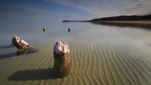
Spring on Good Harbor Bay, photo by Eric Raymond

Good Harbor is located on the northern edge of Sleeping Bear Dunes National Lakeshore at the Lake Michigan end of County Road 651. Today only evidence of the vanished village are the pilings of what was once a 500′ dock that could load 4 schooners at a time. The Good Harbor page from the Lakeshore explains that logging in the area began in 1863 to supply cordwood fuel for  steamers, leading to the founding of a village in the 1870s.

Shortly after 1880 (Henry) Schomberg bought out Schwartz’s interest and built a big sawmill which had a capacity of 30,000 feet in a 10-hour day.

…The Schomberg Lumber Company ran a hotel, two stores which became a shopping center for the local farmers, and a saloon. The township line between Centerville and Cleveland townships ran down the middle of Main Street in Good Harbor. Centerville did not allow saloons, so Good Harbor’s saloon was built on the Cleveland township side of the street … At the height of the lumber business, the mill worked day and night during the winter and during the day in the summer. As many as 75 teams of horses were used hauling logs to the mill, lumber to the dock, and supplies to the camps. The lumber company owned some of the teams and the rest were owned by local farmers and rented to the lumber company. At its peak, the mill cut 8,000,000 board feet of lumber per year.

The schooners were loaded by farmers who were called to work at the dock when the ships arrived. Good Harbor had no protection from storms with a northwest wind, so ships had to leave the dock and sail to the Manitou Islands for protection when a storm would come up. Sometimes storms would come up too fast and the ships were driven aground.

You can read on for more and also see some of the wrecks in the area in the Manitou Passage Underwater Preserve.

Check this out bigger and see more great photos from the Sleeping Bear and Leelanau Peninsula (including another shot of the pilings by Terry Clark) on Eric’s Leelanau County Facebook page.

Wind, Water & Warmth

DSC00936

Untitled, photo by Jben21

As the air heats up we will get these warm and wave-tossing winds in the Great Lakes. The Chicago Tribune explains why spring brings us stronger lake breezes, the coastal wind that blows from the lake to land:

It’s powered by differences in density between warm (less dense) air over land and cool (more dense) air over Lake Michigan. Because temperature greatly affects air density, a lake breeze is most likely to form (and it will blow most strongly) when large temperature differences exist between the “land air” and “lake air.” Those temperature differences are greatest in April and May when the lake air is chilly because Lake Michigan waters still retain much of winter’s cold and the land air is warming strongly in response to the strengthening spring sun.

Check this photo from last April near Muskegon out big as the Big Lake and see more in Jben’s Sunsets on Lake Michigan slideshow. It’s also the cover of the Michigan in Pictures Facebook!

More spring wallpaper on Michigan in Pictures and also lots more cool wind photos!

Sunset & Sequestration

"Lake Michigan Overlook" Pierce Stocking Scenic Drive - Sleeping Bear Dunes National Lakeshore

“Lake Michigan Overlook” Pierce Stocking Scenic Drive, photo by Michigan Nut

The other day on Leelanau.com I posted Sequestration and the Sleeping Bear Dunes detailing cuts that will be made at the Sleeping Bear Dunes National Lakeshore to meet their 5% budget requirement. The Pictured Rocks National LakeshoreIsle Royale and the Keweenaw National Historical Park will all be forced to trim budgets as well. Due to the fact that the NPS fiscal year ends in September, the cuts end up being closer to 10% than 5%.

All of the officials quoted stress that the parks remain open and (mostly) accessible, but when Michigan is spending millions of dollars promoting Pure Michigan nationwide with these parks at the center of our offerings, there’s no question that this is bad news for tourism!

John took this photo about a year ago – view it bigger and see more in his Sleeping Bear Dunes National Lakeshore slideshow. He is a frequent guest on Michigan in Pictures – view more of his posts right here.

Ice Field

ice field

ice field, photo by northernlightphotograph

Check this out on black, see more from Tim on Michigan in Pictures and definitely check out his 2013 Winter Ice slideshow.