Great Lakes approaching record ice cover

Leland & Lake Michigan by Elijah Allen

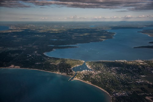
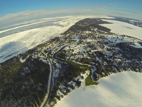
Drone over Leelanau (at Leland), photo by Elijah Allen

Mark Torregrossa writes at mLive that the Great Lakes are nearly 90% ice-covered:

The total ice cover on the Great Lakes continued to increase in the past seven days. At the rate the ice is growing, ice cover would reach record levels sometime next week.

We also had a mostly clear day Tuesday February 11, 2014. The high resolution satellite was able to generate some fascinating images.

The total ice cover on the entire Great Lakes system is reported at 87.3 percent today, according to the Great Lakes Environmental Research Laboratory(GLERL). The ice cover is up from 77 percent covered seven days ago.

The highest recorded total ice cover on the Great Lakes is 94.7 percent back on February 19, 1979. It should be emphasized that the most modern data set only goes back to 1973.

So the entire Great Lakes system has gone from 77 percent ice covered last week to 87 percent ice covered today. At that rate of increase, the Great Lakes would set a new modern day record for ice cover sometime next week.

Click through to mLive for a Lake by Lake report on ice cover and some sweet satellite shots.

My friend Elijah has been having entirely too much fun in and above the snow this winter. Lately he’s been flying a drone above the Leelanau Peninsula to see what he can see. View his photo bigger and (if you can) see more in his Drone over Leelanau Facebook gallery.

More aerial photography on Michigan in Pictures!

A Lighthouse a day keeps the winter away

Frankfort Lighthouse by 22 north

Dawn at Frankfort North Breakwater Light, photo by 22 North Photography

22 North Photography has declared February as Lighthouse Month, sharing 28 Michigan lighthouses in 28 days. Day 1 is the Frankfort North Breakwater Light which marks the entrance to Betsie Lake and the Betsie River in Frankfort.

View the photo bigger on Facebook, keep up on their Facebook page and also see the 22 North Photography website.

Many more lighthouses on Michigan in Pictures.

In between the dark and the light on Empire Bluffs

Sun Spill, Empire Beach

Sun Spill, Empire Beach, photo by jess_clifton

Recently Michigan in Pictures regular Jess Clifton and her family made a wintertime excursion to Empire in the heart of the Sleeping Bear Dunes National Lakeshore. She writes (in part):

At Empire, the beach was already sprinkled with about 10-15 other folks and the scene was surreal. Kids were crawling in and out of caves carved into the thick, massive ice formations built up along the water’s edge. Clouds intermittently descended and receded, offering up dramatic skies that beckoned you out.

…Once I finally convinced myself the beach was “safe” to venture out onto after watching about 14 other people successfully make the trek, I was off cresting mini ice mountains at a snails pace until I could finally peer into the water.

It was there that I finally got a sense of just how still the water was. Pancake ice floated gently on the barely breathing lake. The revelation of something so calm in such a harsh environment was almost jarring. (In a really good way.)

Read on for more and lots of stunning photos in her Why Michigan? blog.

View Jess’s photo background bigtacular and see more in her Winter in Northern Michigan slideshow. She also has a comparison photo from last year.

Lots more winter wallpaper on Michigan in Pictures.

Reflecting

Reflecting by John Gessner

Reflecting, photo by John Gessner

John is a Michigan in Pictures contributor and friend whose photo “Reflecting” was named the first place winner at the Crooked Tree Arts Center’s 34th Annual Juried Photography Exhibition. If you make it up top Petoskey, check out the show which runs through April 5th.

View the photo bigger on Facebook and see more at John A Gessner Photography.

More black & white photography on Michigan in Pictures.

Ice Balls on the Sleeping Bear Lakeshore

Lake Michigan ... ice balls III

Lake Michigan … ice balls III, photo by Ken Scott

You may recall the Lake Michigan ice balls that were seen at the Sleeping Bear Dunes lakeshore last March.  Well, they’re baaaaack. You can see a great video of the ball ice at Accuweather. Here’s the explanation of how balls ice form that I  put together from AIR PHOTO INTERPRETATION OF GREAT LAKES ICE FEATURES by Ernest W. Marshal & Frazil ice at Wikipedia:

Ball ice consists of roughly spherical masses of slush and frazil ice that accrete in turbulent water. Frazil ice is a collection of loose, randomly oriented needle-shaped ice crystals that form in open, turbulent, supercooled water. Lumps that form in the less turbulent zones are typically flattened discs, while those formed in the extremely turbulent zone near the shoreline ice where wave action is strongest form into spheres.

The author explains that ball ice is a feature common to all of the Great Lakes and can occur at any time during the winter where water turbulence breaks up a slush layer. You can read more about this in Great Lakes Ice Features.

View Ken’s photo bigger, check them out in his ice balls slideshow and see this shot with Ken in it for a sense of the scale.

Lake Effect Snow Season in Michigan

Lake Effect 4794-09

Lake Effect 4794-09, photo by StacyN – MichiganMoments

Many in Michigan are waking up to frigid temps, high wind and snow – the perfect conditions for lake effect snow. Meteorologist Robert J. Ruhf has an excellent article on Lake-Effect Precipitation in Michigan that explains lake effect snow and rain are common in Michigan, especially in late fall and early winter as cold polar air moves across the warmer Great Lakes. 

The unfrozen waters are relatively warm when compared with the temperature of the wintertime air mass. Therefore, the temperature of the air that comes into contact with the water increases. The warmed air expands and become less dense, which causes it to rise. This is an “unstable” situation. As the air rises, the temperature decreases until it reaches the dew point, which is the temperature at which the air becomes saturated.. Ice crystals or water droplets will then begin to collect until the force of gravity pulls them down. The result is “lake-effect” precipitation. When the cP air mass is very cold, as is often the case between December and February, the precipitation falls as snow. During late autumn, however, the polar air mass may be warm enough for the precipitation to fall in the form of rain.

“Lake-effect” precipitation can cause substantial intensification of snowfall amounts in very narrow bands, often referred to as “snow belts,” along the leeward (downwind) shores of the Great Lakes. The prevailing wind direction in the Great Lakes region is westerly; therefore, most “lake-effect” precipitation events occur to the east of the lakes.

…An interesting feature of “lake-effect” is that the heaviest bands of snow do not usually occur along the immediate shoreline, but tend to fall several miles inland. Snowfall accumulations are enhanced inland because the air experiences more uplift when it is forced over hills and higher terrain. 

Read on to learn lots more about lake effect snow in Michigan including four narrow bands  – Keweenaw Peninsula, Leelanau Peninsula, the Thumb and the southwest Lower Peninsula – where geographic features and the shape of the shoreline contribute to more intense snowfall. Hang on to your hats – winter is here!

Stacy took this photo of Lake Michigan from the North Muskegon shoreline in January of 2009. See it bigger and see more in her awesome Michigan BLUE Winter 2012 slideshow.

Need a winter background?

The Oldest Ship on the Great Lakes: The St. Mary’s Challenger

Departing…….. by smiles7

7 years ago I shared the story of the Southdown Challenger on Michigan in Pictures. I was happy to see that the oldest operational freighter on the Great Lakes is still in action. The feature on the St. Marys Challenger on Boatnerd.com begins:

Currently holding the honors of being the oldest lake boat still trading on the Great Lakes, the self unloading cement carrier St. Marys Challenger was built as a traditional Great Lakes bulk carrier as hull #17 by Great Lakes Engineering Works, Ecorse (Detroit), MI in 1906. This veteran of the lakes was launched February 7, 1906 as the William P. Snyder for Shenango Steamship & Transportation Co. (subsidiary of Shenango Furnace Co.), Cleveland, OH. Retaining her original overall dimensions, the St. Marys Challenger is now powered by a Skinner Marine Unaflow 4 cylinder reciprocating steam engine burning heavy fuel oil rated at 3,500 i.h.p. (2,611 kW) with 2 water tube boilers. The power is fed to a single fixed pitch propeller and the vessel is equipped with a bow thruster. The vessel is capable of carrying 10,250 tons (10,415 mt) in 8 holds at mid summer draft of 21’09” (6.63m). Cargoes of bulk or powdered cement can be unloaded by a fully automated system including air slides, conveyor equipment and bucket elevators feeding a forward mounted 48’ (14.63m) discharge boom.

Of note, the St. Marys Challenger is one of only two remaining U.S. flagged vessels still active on the Great Lakes to be powered by the classic Skinner Marine Unaflow steam engine. The other vessel is the car ferry Badger (2) which is powered by two of these engines and, in turn, remains as the only coal fired vessel still in active service on the Great Lakes. The only remaining Canadian-flagged steamer powered by a Canadian-built (Vickers) Skinner Unaflow engine is the James Norris.

Read on for more and also check out this set of photos by Wade Bryant, who served aboard the Challenger.

Julie took this shot as the St. Marys Challenger steamed out of Charlevoix last week. Check it out bigger and see more in her boat slideshow.

Many more Michigan ships & boats on Michigan in Pictures!

Support Michigan in Pictures with Patreon

South Manitou Island Lighthouse

South Manitou Lighthouse

South Manitou Lighthouse, photo by HLHigham

Terry Pepper’s Seeing the Light is a tremendous resource for Michigan lighthouse information. His entry on the South Manitou Island Lighthouse begins:

Located just off the mainland coast of Lake Michigan’s east coast, a group of islands known as the Beaver Archipelago form a chain which marked the western edge of a tight passage along the coast. Known as the “Manitou Passage,” vessel masters taking this narrow passage were able to reduce the travel distance between the ports of Lake Michigan’s southern shore and the Straits of Mackinac by sixty miles, as opposed to taking the more circuitous route through open water to the west of the islands. As the most southerly of this chain of islands, South Manitou also featured one of the areas safest natural harbors, and with 5,260-acres of fine timber growth covering the island, it is not surprising that a few enterprising settlers arrived during the mid 1830’s to sell firewood to steamers taking shelter in the harbor when things turned sour out in the lake. By the late 1830’s it was commonplace to find upward of fifty vessels crowded into the harbor seeking refuge and taking-on supplies when things turned sour out in the lake.

Lying a scant few miles west of Sleeping Bear Point, mariners were hard pressed to locate the southern entrance to the busy passage at night or in times of thick weather, and a cry arose throughout the maritime community to light the southern entrance to the passage. Taking up their call on February 19, 1838, Michigan State Representative Isaac Crary entered a motion before the House of Representatives to erect a lighthouse on South Manitou, and fully cognizant of the vital role played by maritime commerce in the area, Congress responded quickly with an appropriation of $5,000 for the station’s construction on July 7 of that same year.

You can read on at Seeing the Light for the troubled saga of this light which saw high keeper turnover and some tragedy in its long tenure before being decommissioned in 1958. There’s also historical photos like this one showing the structure in full operation.

The light & South Manitou Island are now part of the Sleeping Bear Dunes National Lakeshore. Click that link for visitor information and also check out this satellite view of the South Manitou Light!

Check this out background bigtacular and see more shots of the light and the island in Heather’s South Manitou Island slideshow.

Many more lighthouses on Michigan in Pictures!

Our Great Lakes would be a lot less pretty with Asian carp

Lake Michigan near Brevort, Michigan

Lake Michigan near Brevort, Michigan, photo by daveumich

I tried to find something amazing about Lake Michigan – a poem, a legend, anything – but I really couldn’t find something to match up with this stunning photo. I’ll fall back on the real & urgent need to protect the beauty of Lake Michigan and the rest of the Great Lakes from the  very real threat of Asian carp.

Asian carp just suck: massive, leaping fish that seriously injure boaters and eat everything else in the lake. They would be an apocalypse for the $7 billion Great Lakes fishing industry, and it is estimated that just 20 fish getting in would be all it would take.

So of course, yesterday John Flesher (IMO the best environmental journalist in the Great Lakes who also happens to be my neighbor) wrote an article on Asian carp that begins:

The recent discovery of a large Asian carp near Chicago underscores the need to protect the Great Lakes from the voracious fish and other invasive species that could slip into Lake Michigan, two members of Congress said Tuesday.

“If Asian carp are not stopped before they enter the Great Lakes, they could destroy the ecosystem, as well as the boating and fishing industries, and hundreds of thousands of jobs,” said Sen. Debbie Stabenow, a Michigan Democrat.

…John Goss said the 53-inch, 82-pound fish was caught about a month ago in Flatfoot Lake, on the Illinois-Indiana state line.

Flatfoot Lake is landlocked and surrounded by a berm that would prevent it from flooding and enabling Asian carp to escape, said Chris McCloud, spokesman for the Illinois Department of Natural Resources.

But it’s very close to Chicago’s Lake Calumet, where commercial fishermen landed a 3-foot-long Asian carp in 2010 about six miles from Lake Michigan. Lake Calumet and Lake Michigan are connected by the Calumet River.

The latest find “is another reminder that we must find a permanent solution to protect the Great Lakes,” Rep. Dave Camp, a Michigan Republican, said Tuesday.

Indeed. How about we work on that? The Great Lakes are far too beautiful to be filled with the likes of Asian carp. If you agree, please share this with others. We can do something about this threat to our lakes.

Check this photo out background bigtacular, see more in Dave’s slideshow and also check out his photography website, Marvin’s Gardens including a shot of what I’m pretty sure was his breakfast up on Brevort Lake!

Regrettably, there’s more Asian carp on Michigan in Pictures.

Charlevoix, the Beautiful

Charlevoix the Beautiful

Charlevoix the Beautiful, photo by GLASman1

Wikipedia entry for Charlevoix (pronounced shar-le-voy) says:

The city is situated between Lake Michigan and the western end of Lake Charlevoix, which drains into Lake Michigan through the short Round Lake/Pine River complex in the heart of downtown Charlevoix. Charlevoix’s Round Lake has been called the best natural harbor on Lake Michigan.

Charlevoix is named after Pierre François Xavier de Charlevoix, a French explorer who travelled the Great Lakes and was said to have stayed the night on Fisherman’s Island one night during a harsh storm. It was during this time that Native Americans were thought to have lived in the Pine River valley.

The City of Charlevoix website adds that Charlevoix first became a village in 1871 and was later established as a city in 1905. The city has a year round population of roughly 3,000 people. FYI, Round Lake is the little lake right off Lake Michigan whick opens into the much larger Lake Charlevoix – here’s a map of Charlevoix!

View Mark’s gorgeous aerial photo bigger and see more in his Aerials slideshow.

There’s more aerial photography and more about Charlevoix on Michigan in Pictures!