Most of the schools in Michigan were closed today due to single digit or subzero temps as the entire state wonders what box it put the electric blanket in. ArborWiki’s entry for Barton Dam says that:
The City of Ann Arbor purchased the dam from Detroit Edison in the 1960s and restarted hydroelectric generation in the 1980s. The facility has a 900-kilowatt turbine that generates 4.2 million kWh per year.
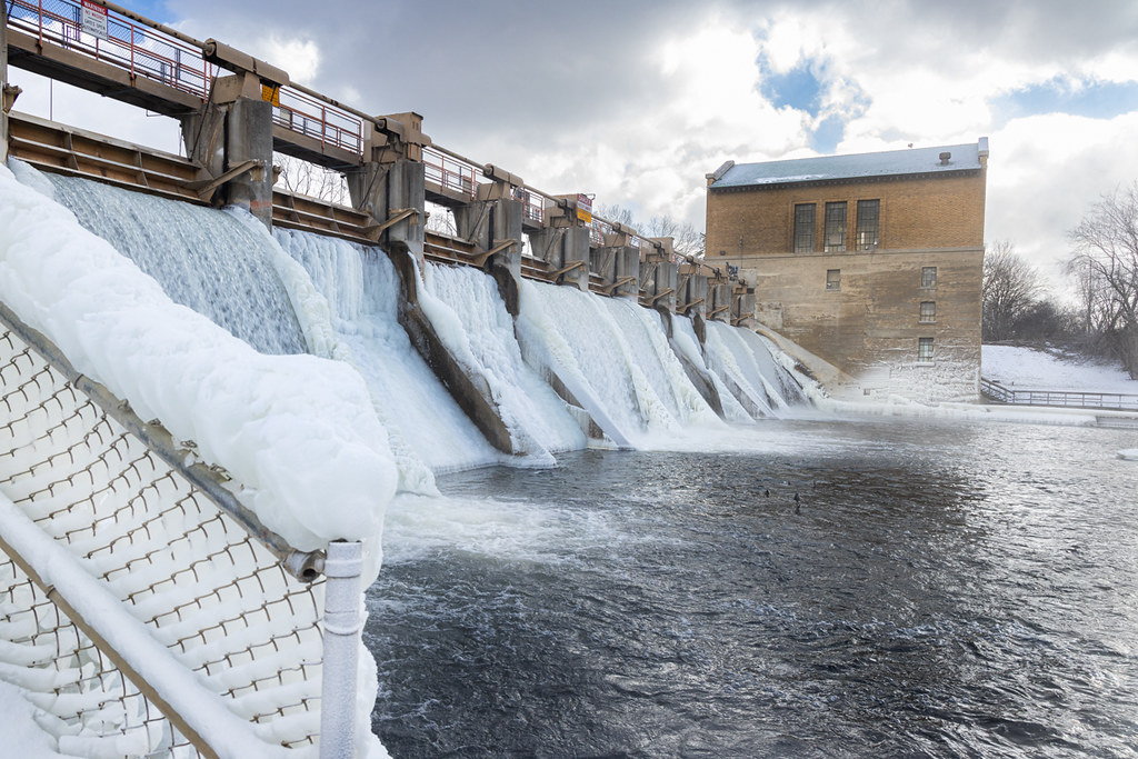
Barton Dam is one of Ann Arbor’s four dams on the Huron River. It was designed by engineer Gardner Stewart Williams and architect Emil Lorch and built in 1912-13 as part of the development of hydroelectric power on the Huron River by the predecessor of Detroit Edison. The earthen-construction dam is 34 feet high and 1767 feet long, and has a typical surface area of 315 acres and typical storage of 5050 acre-feet. The dam can be accessed from Huron River Drive from the city park located at the foot of Bird Road.
See more including another shot from Barton Dam Nature Area in Bruce’s 2025-01 gallery on Flickr and STAY WARM!!!
January 21st is National Squirrel Appreciation Day, and I just learned that Michigan has NINE different squirrel species! Fox, gray, red and flying squirrels nest and spend most of their time in trees while chipmunks, woodchucks and ground squirrels have dens underground and rarely spend time in trees. Here’s the list – both of Corey’s pics from Ann Arbor show Eastern fox squirrels.
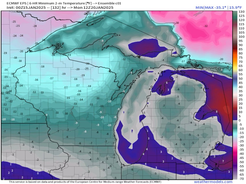
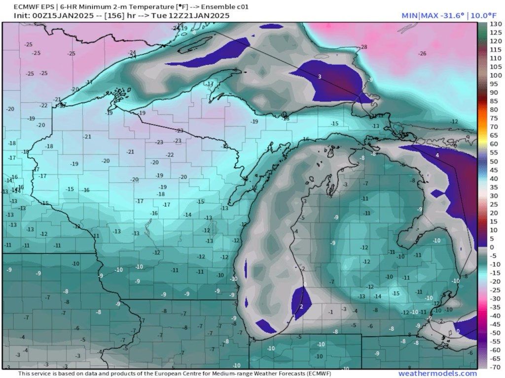
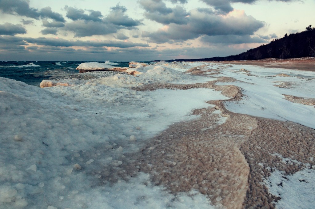
When we get our normal cold here in Michigan the air moves from southwest Canada, across the northern Plains and into the Great Lakes region. A little stiffer brand of cold comes from northwest Canada in the Yukon Territory. Our most dangerous cold comes straight from the north. If the air is really cold it will originate in Siberia, cross over the North Pole and then pour south into the Great Lakes and Northeast.
We are probably just lucky the Great Lakes still have 35 degree to 40 degree surface waters. This same Arctic outbreak of cold would take us 10 degrees colder if it happened with colder Great Lakes’ waters. In looking at the pattern I wouldn’t be surprised to see another Arctic outbreak in a week or two when the lake water is colder.
Lucky indeed because even with the temperature moderation of the Great Lakes, the temps Monday & Tuesday do not look fun!
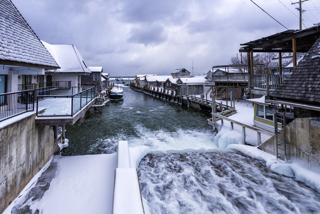
Charles is one of Michigan in Pictures’s most enduring photographers. He took the photo below earlier this week in Leland’s Fishtown & you can see more in his Steam Engine, Railroad Photos gallery on Flickr.
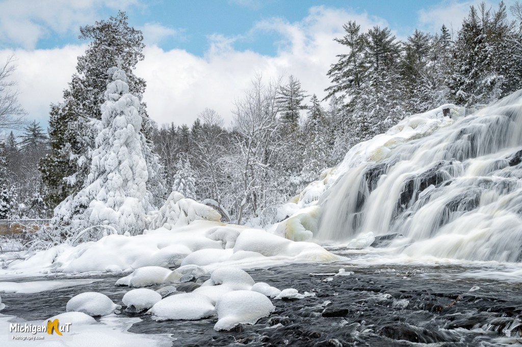
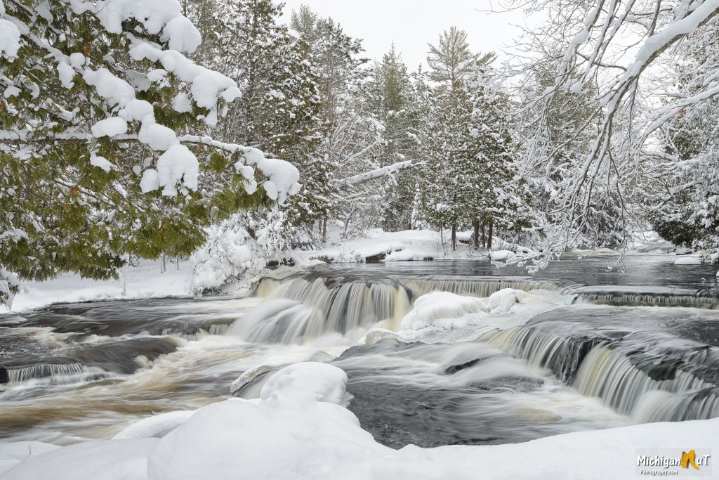
Pure Michigan shares that lower Bond Falls is a scenic and popular waterfall in the Upper Peninsula’s Ontonagon County that is created by the middle branch of the Ontonagon River tumbling over a thick belt of fractured rock that divides it into numerous small cascades. Total drop of the falls is approximately 50 feet & you can get directions & more from the DNR page for Bond Falls Scenic Site.
I originally saw this photo posted by a Facebook page not affiliated with the photographer, something that has become increasingly common. I really hope we can all endeavor to share info & links for the photos we share and to block & report pages that steal photos from actual photographers!
You can view & purchase more Michigan waterfall pictures including these on John’s website, and also get prints, canvas, puzzles, photo coasters, note cards, and Michigan calendars at michigannutphotography.com so what are you waiting for?
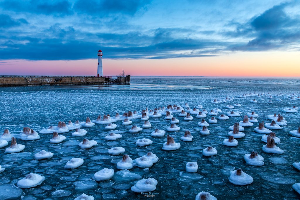
Pure Michigan shares that Wawatam Lighthouse started life in 1998 as a Michigan Welcome Center travel icon at Monroe, Michigan. In 2004, the Monroe Welcome Center was being revamped and the lighthouse was put up for relocation. The City of St. Ignace was the lucky recipient and the structure was trucked north in five pieces. It stayed on the Chief Wawatam Dock for a time, awaiting the construction of its new platform … The Wawatam Lighthouse beacon was first lit on August 20, 2006. Visible for more than 13 miles out over Lake Huron, it is now an official aid-to-navigation. The 250 millimeter Fresnel lens casts its light in a 152 degree arc.
Robert writes “Four of us from my camera club decided to visit Michigan’s U.P. in search of the Snowy Owl. We left early and before we got up to the hunting grounds, we stopped by St. Ignace to see the sunrise. This area of Lake Huron was not frozen over yet even though it was about -5 degrees this morning. One did not stay outside the car very long with the blowing breeze.”
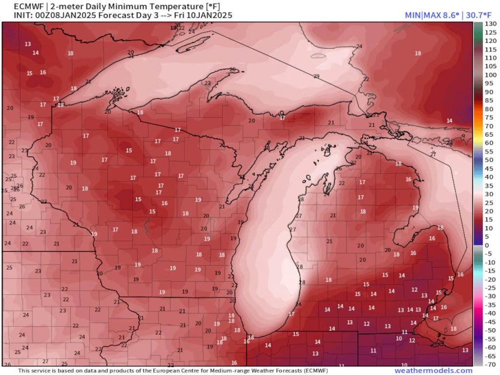
Several times a year I can point out to you weather we see nowhere else in America. One of those times is when we get Arctic air crossing the 40-degree water of Lake Michigan.
Look at the low temperature forecast for tomorrow morning, Jan. 9. You could call a friend in northeast Lower Michigan, and they will tell you it’s very cold and near zero degrees. Look at the “warmer” air that blows off of 40-degree Lake Michigan. We will have spots around Kalamazoo, South Haven and Benton Harbor that only drop to 20 degrees. Southeast Lower Michigan can be colder than the northwest shoreline of Lake Michigan at this time of year. Thursday morning’s map clearly shows that strange temperature pattern. We also see the warmer air under the clouds and lake effect snow stretching southeast off Lake Michigan.
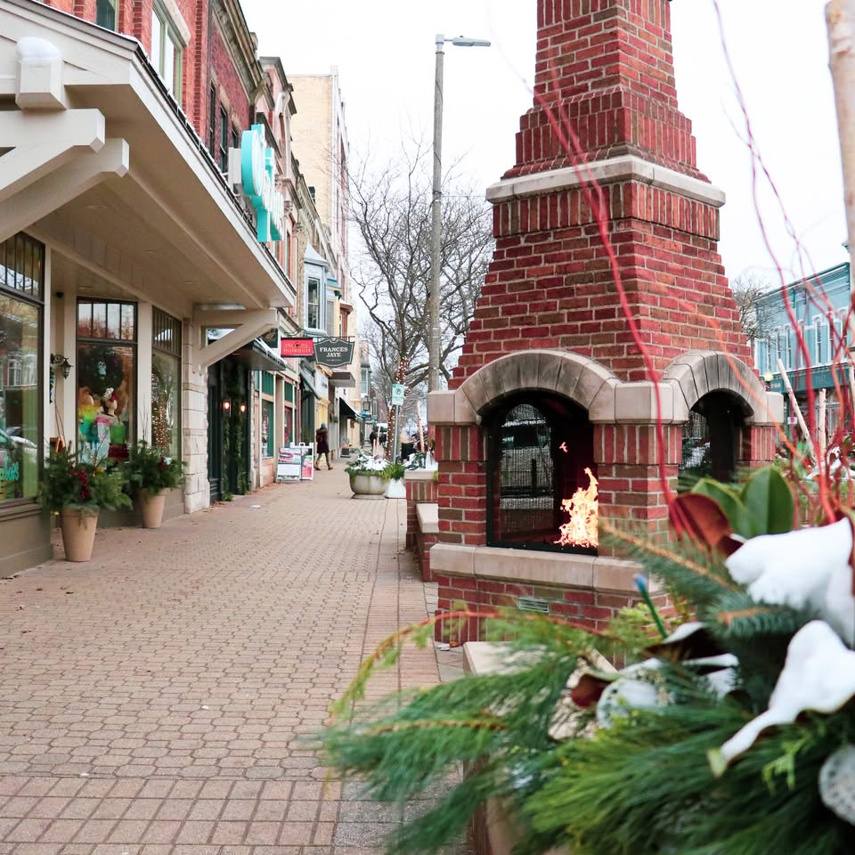
One of the stories you read more & more every year is how online shopping is killing downtowns. Discover Holland shares that in the 80s when suburban malls were wreaking similar havoc, downtown Holland business owners & the city created a plan for Snow Free Holland, now the largest municipal snowmelt system in North America:
Joining the conversation was Holland native and Prince Corporation founder, Edgar D. Prince. Prince brought to the table an idea that he discovered while in Europe, a system of underground piping that circulates warm water to keep the snow and ice at bay during the winter months. Using this idea, Prince expanded on the possibilities of snow and ice free access in downtown, and thus began the downtown Holland snowmelt project.
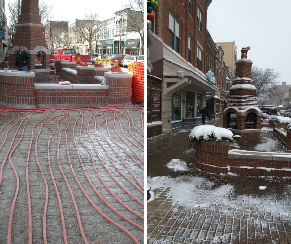
Currently, snowmelt is maintained by the Holland Board of Public Works in collaboration with the Holland Energy Park. Snowmelt was first implemented in 1988 and is the largest municipally-run snowmelt system in North America. By using waste heat from power generation, water is heated and circulated through 120 miles of plastic tubing underneath the streets and sidewalks. The tubes are 3/4″ in circumference; Holland has 600,000 square feet of tubing totaling 4.9 miles and 10.5 acres of heated streets and sidewalks. With the water heating up to 95 degrees Fahrenheit, the system can melt 1″ of snow per hour – even at 20 degrees F with 10 MPH winds!
Active dunes gradually advance over time. In some places trees and telephone poles have been buried in drifting sand over a period of several years. A common question is “How fast are the dunes moving?” Rates of sand movement vary from one place to another and from one year to the next. At the Dune Climb the average rate of advance has been about 4 feet (1.2 meters) per year over the past few years.
Direction of sand movement also varies from one place to the next. The shapes of dunes reveal the direction of the winds. Dry, loose sand can take on a maximum slope of 34 degrees, known as the angle of repose. As sand piles up on an unvegetated dune, the leeward (downwind) slope approximates the angle of repose, while the windward slope is more gradual. Ripples in the sand show a similar asymmetrical shape.
Dune sand moves primarily by a process called “saltation”, literally “jumping”. Wind forces grains of sand to roll, collide with other grains of sand, and in subsequent collisions some grains bounce into the air, are driven downwind as they fall, and upon landing strike other grains to produce a chain reaction. On a windy day you can see a hazy zone of sand moving just a foot or two above the ground.
Neil took the photo above last year in late December & shared “One of the many things that I love about hiking around the sand dunes is finding miniature landscapes created by the strong winds. The textures and lines compose a true natural work of art!”
EarthSky shares that since the radiant – the point in the sky from which the meteors appear to radiate – for the Geminid Meteor Shower rises in mid-evening, you can watch for these meteors all night long in the days before & after the evenings of December 13-14 as we pass through the Geminid swarm. They say that the radiant is highest at 2am. Although you won’t see the 20 meteors per hour with the nearly full Cold Moon hanging in the sky, they are particularly bright & you will see some if you give it 15 minutes or so!
Speaking of the meteors & the moon, EarthSky & other outlets have shared video of meteor impacts on the lunar surface from Japanese astronomer Daichi Fujii, the curator of the Hiratsuka City Museum! Check it out below along with tips on how to get the best view of this annual meteor shower!
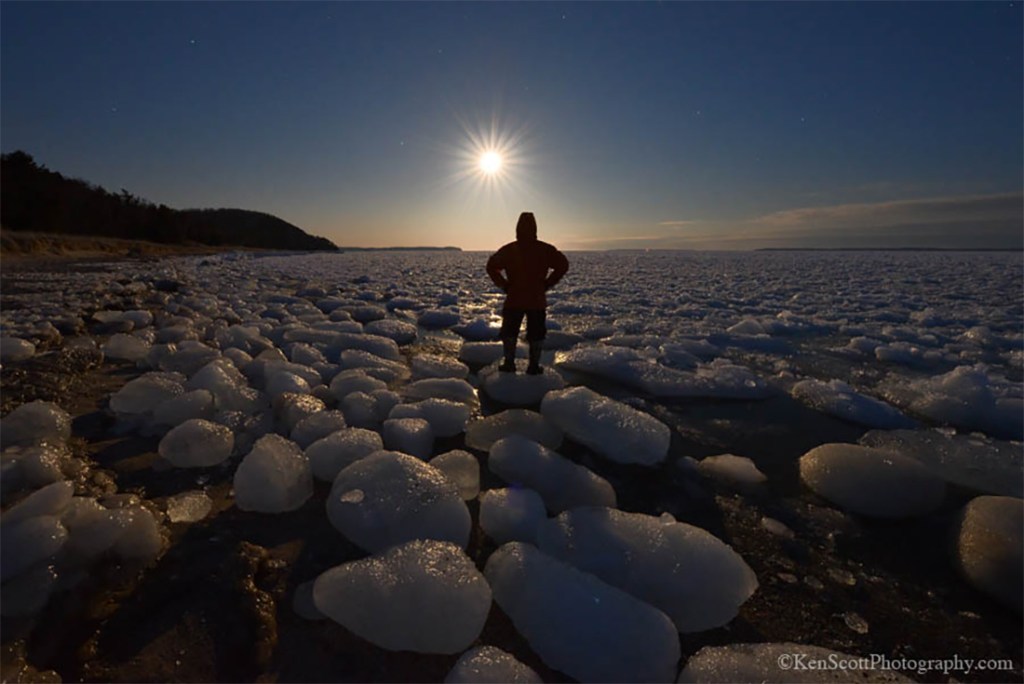
Ken took this back in April of 2015 when he was hoping to catch a lunar eclipse but sadly…
this morning was to be a Total eclipse of the moon … it started out fantastic and then clouds rolled in . . .
Follow Ken Scott Photography on Flickr & Facebook for his latest! Also if you are wondering about the ice balls, Leelanau.com has the info on that too with another pic from Ken & video by Paul May!
In Lower Michigan the winter storm watch stretches from the Kalamazoo area northward through the Grand Rapids area and up the western shoreline through Muskegon, Grand Traverse area and Charlevoix. Cadillac is also in the winter storm watch. The western Lake Superior shoreline counties in the Upper Peninsula are also in the winter storm watch.
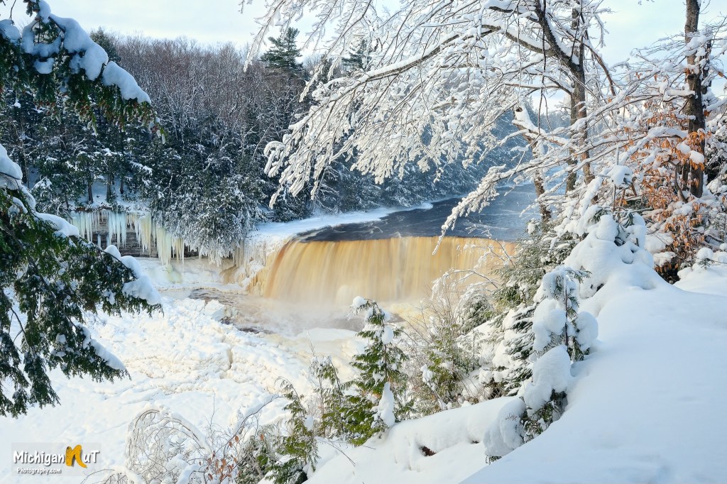
You can find this shot from Michigan’s largest waterfall & many others in the Winter in Michigan gallery on the Michigan Nut Photography website. John also shares much more on his Facebook!