Flying High at Suicide Hill

Flying High at Suicide Hill

126 Suicide Jumps, photo by PhotoYoop

Cory writes that he attended the 126th annual ski jumping tournament Friday night at Suicide Bowl in Ishpeming, where skiers have been jumping annually since 1887! It’s run by the Ishpeming Ski Club. You can get more photos on their Facebook where I also found a video by Under the Radar Michigan.

Here’s a feature by Bob Garrett of Seeking Michigan about the history of Ishpeming’s Suicide Hill from a couple of years ago on Michigan in Pictures.

Check his shot out bigger and see more in his ski slideshow. Be sure to follow him on Facebook too!

More skis and skiing on Michigan in Pictures.

Ice Climbing in Munising

Ice Climing in the Pictured Rocks

HMR Ice in Pictured Rocks, photo by Luke Tikkanen

The abundant waterfalls that make the Pictured Rocks National Lakeshore such a treat in summertime turn it into an amazing mecca for ice climbing every winter. Since 1983, Down Wind Sports has organized and promoted the Michigan Ice Festival in Munising. The event brings some of the top ice climbers in the world and features product demos, presentations, intro to climbing and plenty of climbing socials. 2013 dates are January 31 – February 3, so consider a trip north next weekend!

Today’s photo is the cover of the forthcoming edition of An Ice Climbers Guide To Munising Michigan by Jon Jugenheimer and Bill Thompson. There will be a release party for the book next Thursday (Jan 31) at Sydney’s in Munising. They explain:

Pictured Rocks National Lakeshore has been called one of the premier ice climbing areas in the country. Nestled on the southern shore of Lake Superior, it is renowned for its beautiful setting and phenomenal ice routes. This edition An Ice Climbers Guide To Munising Michigan offers the most thorough and up-to-date information, maps, and descriptions of the major ice climbing formations.

Click through for more about the book including some more great photos. This climb is known as HMR, out by Grand Portal Point in the Pictured Rocks. Here’s a panoramic photo of the climb in relation to the Portal.

Ice Arch: Cold grips Michigan

Ice Arch

Ice Arch by adonyvan, photo by adonyvan

Got to love what a lake like Superior can carve out of ice.

Right now the coldest air of the last 4 years has settled in across Michigan. Metro Detroit will see wind chills below zero today, Bay City/Saginaw and the surrounding area faces single digit temps and wind chills 15-20 degrees below zero, and it’s just 1 degree right now in Traverse City with double digit wind chills. A scan of Michigan temps shows Ironwood leading the way at a frigid -18 degrees with wind chills up to -26 expected. Bundle up!!

Here’s a funny chart about how Michiganders deal with cold via Absolute Michigan!

View on black and if you want a treat, kick back and watch Jiqing Fan’s Houghton & UP MI slideshow.

More cold on Michigan in Pictures!

Bishop Baraga, the Snowshoe Priest

Bishop Baraga Shrine, L'Anse

Bishop Baraga Shrine, L’Anse, photo by RPM-Photo

Bishop Frederic Baraga passed away 145 years ago on January 18, 1868. He was born on June 29, 1797* in the castle of Mala vas in the Northwestern part of Slovenia, and for over half of the 71 years of his life Baraga covered a vast territory of over 80,000 square miles in Michigan, Wisconsin, Minnesota and Canada. The history page at the campaign for sainthood of Bishop Baraga explains that:

Father Baraga arrived in the New World on December 31, 1830. For the next 37 years he travelled the length and breath of the Great Lakes area to minister to the Ottawa and Chippewa Indians. His first mission (Arbre Croche, 1833-1835) was established along the shore of Lake Michigan at present day Harbor Springs to Cross Village. Fr. Baraga labored two years at Grand River (1833-1835) presently known as Grand Rapids, before moving his mission to LaPointe (1835-1843) and L’ Anse (1843-1853) on Lake Superior. During the summer months, Father Baraga traveled on foot and by canoe. During the winter months, he traveled on snowshoes thus giving him the titles of “Apostle of the Lakelands” and “Snowshoe Priest.” He wrote long and frequent accounts of his missionary activities including a three-volume diary. He also wrote seven Slovenian prayerbooks and authored 20 Native American books which inlcudes his monumental Grammar and Dictionary of the Chippewa Language , still in use today. He was the first bishop to write a pastoral letter in both the English and Chippewa languages.

From 1840 to his death, he ministered to the immigrants who came to the Upper Peninsula of Michigan to work in the iron and copper mines of the region. About the same time, he began the practice of rising at 3 a.m. in the summer and 4 a.m. in the winter to spend three hours in prayer, which he continued until the end of his life. His responsibilities grew even greater when he was named bishop of the newly created Vicariate of the Upper Michigan. He was consecrated bishop in Cincinnati on November 1, 1853. The lack of priests and money weighed heavily on his heart. Due to his hard work and dedication, Bishop Baraga was able to report to the Holy See a year before his death that his diocese rested on a firm foundation, with enough priests and churches for the fast-growing area. Sault Ste. Marie was his See City until 1866, at which time he moved to Marquette-a more centrally located and accessible city by both ship and train. In the Fall of 1866 while attending the Council of Baltimore, Bishop Baraga suffered a severe stroke. Afraid that his fellow bishops would not allow his return to the severe climate and remote regions of Lake Superior, he begged the priest who accompanied him (Rev. Honoratus Bourion) to take him back to Marquette. Understanding his bishop wanted to die among his flock, Rev. Bourion practically carried Baraga to the train for the long trip back to Marquette.

There’s a lot more about Baraga there including an excellent tour of Baraga’s life in the Upper Peninsula that I imagine would make a great vacation.

You can have a look at Bishop Baraga right here and read more in the entry for the Venerable Frederic Irenaeus Baraga in Wikipedia where I found the link for an online version of Father Baraga’s 1853 Ojibwe Dictionary. Here’s the direct link to the dictionary. You can read more about the Baraga shrine at Roadside America.

View RPM’s photo on black and see more in his Mich-ellaneous slideshow.

*Coincidentally enough, that’s my birthday too!

The Michigan Moose Lift

Like posts like this? Please consider supporting Michigan in Pictures through Patreon!

Michigan Moose Reflections

Moose Reflections, photo by yooper1949

NOTE: I’ve edited this post because the State of Michigan removed it from the internet. Thank you archive.org for saving it via The Wayback Machine so I could share it in its entirely!

Remembering Michigan’s Historic Moose Lift from the Michigan DNR says:

On Jan. 20, 1985, separate convoys carrying men and equipment set out from Michigan on a mission to reach the 3,000-square-mile Algonquin Provincial Park in Ontario, Canada.

Over the next two weeks, this team of wildlife biologists and veterinarians from the Michigan Department of Natural Resources, working with a team of Canadian specialists from the Ontario Ministry of Natural Resources, would locate, capture, transport and release a number of wild moose to form the nucleus of a new population in Michigan’s Upper Peninsula.

It was an unprecedented, historic operation. The wind chill at times approached 100 degrees below zero. Utilizing helicopters, tranquilizing dart guns and slings, some moose were air-lifted as far as 14 miles from the capture area to base camp.

At base camp, each animal was subjected to thorough medical testing and was fitted with a sophisticated radio collar, before being lifted into a shipping crate and placed onto a transport truck for the non-stop 600-mile overnight journey back to Michigan.

The remarkable effort was called “moose lift.” A total of 29 moose (10 bulls, 19 cows), ranging in size from 750 to 1,250 pounds, survived the arduous journey.

Crowds assembled each day at the release site north of Lake Michigamme in Marquette County. Despite temperatures well below zero, a welcoming committee of U.P. residents always showed up to greet the new “American” citizens.

As we mark the 20th anniversary of the first moose lift, the most common question that arises is, “How are the moose doing now?”.

“The department’s goal was to produce a self-sustaining population of free-ranging moose, and we have that,” said Dean Beyer, wildlife research biologist for the Michigan Department of Natural Resources.

Since the first moose lift in 1985, and a similar effort two years later when another 30 moose were released in the same area, the DNR has closely monitored the reintroduced moose population.

“At first, the size and growth of the herd was determined through a simple process–similar to balancing a checkbook,” Beyer said. “Because all moose were radio-collared, biologists could monitor each animal and tell when it died, and they could follow cows to record any births. The population could be tracked simply by adding the number of calves born and subtracting the number of animals that died.”

As the population grew, the new animals in the herd did not have radio collars.

“Over time, maintaining an adequate sample of radio-collared animals for the population would not be feasible,” Beyer said.

So in 1996 and 1997, the DNR conducted aerial surveys, which are the most common method of estimating moose numbers. Unfortunately, the population estimates from the aerial surveys were lower than estimates from the population model.

“At that point we knew we needed to conduct a more intensive study of the reintroduced population,” Beyer said. “And we also wanted to determine a more accurate picture of what’s reasonable growth for this population.”

With the help of the Michigan Involvement Committee of Safari Club International, which also provided the single largest financial contribution to the first moose lift, the DNR began a more intensive study of the reintroduced population in 1999, in cooperation with Michigan State University.

“Our research team is developing a technique to estimate the size of the population by estimating the probability of seeing moose from an airplane given the group size; behavior, whether the animal is standing or bedded; and the amount of canopy cover,” Beyer said.

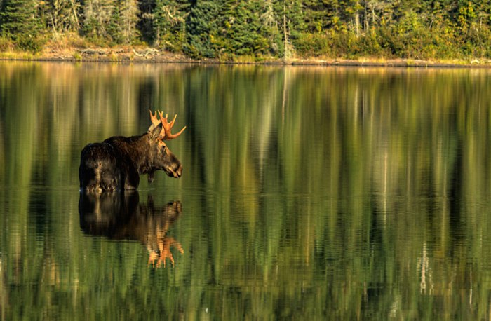
When the moose were reintroduced into the western Upper Peninsula, biologists hoped the population would grow to 1,000 animals by the year 2000. Although that objective was not reached, results of the current study indicate the population is growing, on average, between five and ten percent each year. The research also has shown that poaching, moose/car accidents, brainworm and wolves are not major factors influencing the moose population at this time.

According to Beyer, the herd ranges over approximately 1,800 square miles in Marquette, Baraga and Iron counties. Moose also are found in several parts of the eastern U.P., most notably around the Tahquamenon River.

“Moose in this region have not been studied in detail,” he said.

Although records from the early explorers show that moose were common throughout Michigan, by the late 1800s moose numbers were very low. Moose soon disappeared from the Lower Peninsula and only a small number survived in the U.P., perhaps supplemented by animals coming in from Minnesota and Canada.

Thanks to the vision and hard work of many DNR biologists a generation ago, moose are once again establishing themselves as a premiere Michigan mammal.

Several U.P. communities, in fact, now vie over the self-proclaimed title, “Moose Capital of Michigan.” Mascots, motels, restaurants, candy and even ice cream are named after the mighty moose. Its image is common on billboards, television, artwork and printed materials. But most importantly, moose are alive and well, and rambling about in the wilds of Michigan’s Upper Peninsula once more.

Here’s a great video about the Moose Lift – highly recommended!

The last DNR moose survey pegs the UP’s moose population at about 500 with another 750 on Isle Royale.

Carl took this shot on Isle Royale in September. Check it out big as a moose and see much more (including some more moose shots) from one of Michigan’s coolest parks in his Isle Royale slideshow.

More moose on Michigan in Pictures!

Northern Lights likely this week!

Northern Lights

Northern Lights, photo by BeaverTripp

The Space Weather Prediction Center of the National Oceanic and Atmospheric Administration says that minor to moderate auroral activity is likely through January 20th. Translation? Northern Lights are likely this week!

You can click to register for space weather alerts and also view the current space weather.

Stephen captured this photo in July of 2012 on Moss Lake in the U.P. Check his photo out as big as the sky and in his Northern Lights slideshow.

Much (much) more Aurora Borealis information & photos on Michigan in Pictures!

Eben Ice Caves in the Rock River Wilderness

A Healthy Green Glow

A Healthy Green Glow, photo by nasunto

I know it’s wintertime when I start seeing a lot of people asking about the Eben Ice Caves. Like many of the subjects on Michigan in Pictures, I don’t know much more than what I write on the blog. Recently, however, a good-hearted soul created the Eben Ice Caves Facebook page to serve as a hub for information about this wintertime wonder of Michigan.

Nina Asunto writes one of my favorite blogs, Black Coffee at Sunrise, a delightful wander through some of Michigan’s most fascinating places. Nina’s feature on the Eben Ice Caves explains that they are located in the Rock River Wilderness in the western section of Hiawatha National Forest.

Rock River Canyon is 150 feet deep and lined with sandstone outcrops, which have been eroded to form concave overhangs. During winter, ground water seeps over the edge and down through the sandstone where it freezes, creating huge curtains of ice and closing off the front of the outcrops to form caves.

In winter it is possible to access the ice caves from the south side of the wilderness area. A few miles north of Eben Junction, visitors can park their cars by the side of the road and cross an open field to the forest. The field is private property, but the owner allows for its use in winter to access the ice caves…

We had both seen a few photos of the ice caves, but none of them really captured the size of this phenomenon…

What we weren’t able to capture, however, was the amazing sound inside the cave. The drips of water falling from above created wonderful echoes and added to the cave atmosphere. There is much variation of color and texture to the ice in different parts of the cave. Some formations were smooth and clear, others were bumpy and hollow-sounding, and there were some columns that looked like dripping candle wax.

Read on for many more photos. You can also view this photo background bigtacular and see more in her fantastic Eben Ice Caves slideshow on Flickr!

More Eben Ice Caves on Michigan in Pictures.

Draco, Snowmageddon and the naming of winter storms

Fierce

Fierce, photo by farroutdude

Meteorologist Paul Gross of WDIV has a nice forecast for Michigan & Metro Detroit (although the weather maps were a little confusing to me). In Winter Storm Draco ends record snowless streaks across Midwest, Dr. Jeff Masters of the Weather Underground adds that:

Winter Storm Draco is powering up over the Upper Midwest, and is poised to bring a resounding end to the record-length snowless streaks a number of U.S. cities have notched this year. Blizzard warnings are posted over portions of Colorado, Nebraska, Kansas, Iowa, Illinois, and Wisconsin, and snowfall amounts of up to a foot are expected in some of the affected regions. While the heavy snow will create dangerous travel conditions, the .5″ – 1.5″ of melted water equivalent from the the storm will provide welcome moisture for drought-parched areas of the Midwest.

…Average water levels on Lake Michigan and Lake Huron are near their lowest December levels ever recorded, preliminary data from NOAA’s Great Lakes Environmental Research Laboratory indicate. The U.S. has had its warmest and 12th driest year on record, according to NOAA’s National Climatic Data Center. It should be no surprise, then, that a number of major cities have set records for their longest period without snow. Most of these streaks have come to and end (or will do so in the next day or two) because of Winter Storm Draco.

Draco? You might be wondering when & why we started naming winter storms. The answer is actually due to social media:

A new naming system put in place by The Weather Channel has its roots in social media to make it easier for people to communicate and share information about winter storms. The network is the first to name them, similar to how tropical storms and hurricanes have been referenced for years.

“In addition to providing information about significant winter storms by referring to them by name, the name itself will make communication and information sharing in the constantly expanding world of social media much easier,” The Weather Channel meterologist Tom Niziol wrote on the site. “As an example, hash tagging a storm based on its name will provide a one-stop shop to exchange all of the latest information on the impending high-impact weather system.”

Mind your dragons folks and enjoy the last day of the 13th b’ak’tun cause the next time doesn’t roll around for 394.25 years!

See the dragon in faroutdude’s photo? View it on black and see more in his Marquette slideshow.

More Michigan blizzards on Michigan in Pictures.

Andy’s Trees … and Michigan Bigfoot

Andy'sTrees

Andy’s Trees, photo by swatzo

I’m guessing these trees aren’t for me, but I still love them. Another thing that I’ve loved since I was a kid was the search for Bigfoot. mLive reports that last April, the team of Bigfoot researchers from Discovery Channel’s Finding Bigfoot show came to Michigan:

After their first search yielded no sightings or additional evidence, BFRO held a town hall meeting in Houghton Lake to solicit additional leads from local residents. A show of hands revealed that a large group of those gathered had seen what they thought was a Bigfoot creature. One woman had made recordings of what she claimed could be a sasquatch which prompted Moneymaker to investigate further.

During the second night of searching, BFRO was joined by Mike Berg, a Michigan Bigfoot tracker. Berg partnered with Barackman to explore one tract of forest while Moneymaker camped out in a tree stand on the property of the woman who had made the sound recordings. While both locations yielded sounds that were thought to be from a Big Foot creature, no visual evidence was obtained.

Meanwhile, Holland and Fay were investigating woods where a local boy reported a sasquatch sighting. The two attempted to communicate with the creature by making different types of calls at varying pitches. After hearing several wood knocks after the calls, Bobo clapped back, which was followed by more of the wood knocks. The knocks were followed by movement on the road, but their chase also failed to provide a definitive picture of sasquatch.

Watch a clip at the Finding Bigfoot website and also on YouTube. The episode airs this Saturday at 7 PM and other times this week on Discovery. More about Bigfoot in Michigan at the Michigan Bigfoot Information Center.

Check this out on black and see more in Steve’s slideshow.

More trees on Michigan in Pictures.

More Michigan Cougar Photos Verified

November 11, 2012 Upper Peninsula Cougar, photo courtesy Michigan DNR

The Michigan Department of Natural Resources announced yesterday that three recent trail camera photos of cougars in the Upper Peninsula have been verified by the DNR:

Two of the photos, both of a cougar with a radio collar, were taken in October in Menominee County – one near Cedar River and one near Menominee just north of the Wisconsin border. The third photo was taken in northern Marquette County in November. The cougar in the Marquette County photo is not wearing a radio collar.

The DNR does not place radio collars on cougars; North Dakota and South Dakota are the nearest states where wildlife researchers have placed radio collars on cougars to track their movement. The DNR has not yet been able to determine the origin of the radio-collared cougar that is in Michigan.

…DNR Wildlife Division staff have now verified the presence of cougars in the Upper Peninsula 20 times since 2008.

To date, the DNR has confirmed 11 photos, eight separate sets of tracks, and one trail camera video from 10 Upper Peninsula counties: Baraga, Chippewa, Delta, Houghton, Keweenaw, Mackinac, Marquette, Menominee, Ontonagon and Schoolcraft.

“The increasing number and frequency of verified cougar sightings in recent years are likely due to three factors in particular: The growing popularity of trail cameras used to monitor wildlife activity in the woods 24 hours a day; additional transient cougars moving east from established populations in western states as they seek new territory; and the cooperation of the public in reporting cougar sightings and sharing their photos with us for official review, which we greatly appreciate,” said Adam Bump, one of four DNR biologists specially trained to investigate cougar reports.

The DNR adds that cougars may travel hundreds of miles in search of new territory – as far as Connecticut from South Dakota.

You can report cougar tracks and other evidence should be made to a local DNR office or by submitting the sighting on the DNR’s online reporting form at www.michigan.gov/cougars.

More on the Michigan cougar saga on Michigan in Pictures.