Paradise is the nickname of this place

Paradise is the nickname of this place

Paradise is the nickname of this place by Shawn Malone

Shawn says she crawled into this cave on Lake Superior when it was warm this summer.

View it bigger on Facebook and see more of her work at Lake Superior Photo … but don’t bother asking her where it is because she’s not telling … or me, because I don’t know!

Exploring the Eben Ice Caves

Exploring the Ice Caves

Exploring the Ice Caves, photo by Michigan Nature Photog

View Greg’s photo bigger and see more in his great Winter slideshow. Catch another shot of the ice caves here and here on Facebook. While you’re there, Greg is also holding a contest and giving a print to 2 winners!

Last year I shared a photo feature on the Eben Ice Caves by Nina Asunto. On Black Coffee at Sunrise, her excellent blog of explorations of Michigan’s wild places, she writes (in part):

During winter, ground water seeps over the edge and down through the sandstone where it freezes, creating huge curtains of ice and closing off the front of the outcrops to form caves.

We had both seen a few photos of the ice caves, but none of them really captured the size of this phenomenon. It was difficult to decide where to begin to tackle it photographically, and we immediately began climbing around the hillsides to get a more expansive view, and crouching and crawling around at the base of the ice to see every possible angle…

What we weren’t able to capture, however, was the amazing sound inside the cave. The drips of water falling from above created wonderful echoes and added to the cave atmosphere. There is much variation of color and texture to the ice in different parts of the cave. Some formations were smooth and clear, others were bumpy and hollow-sounding, and there were some columns that looked like dripping candle wax.

Read more on her blog and get lots more on this transitory Michigan wonder on Michigan in Pictures!

2014 Michigan Ice Fest & Ice Climbing in Pictured Rocks

UP Michigan Ice Fest001

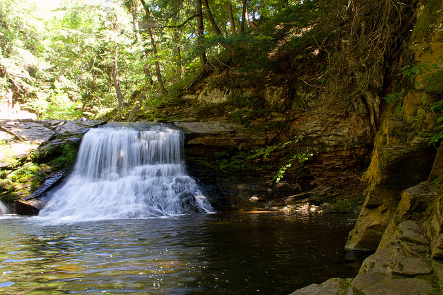
UP Michigan Ice Fest, photo by ebaillies

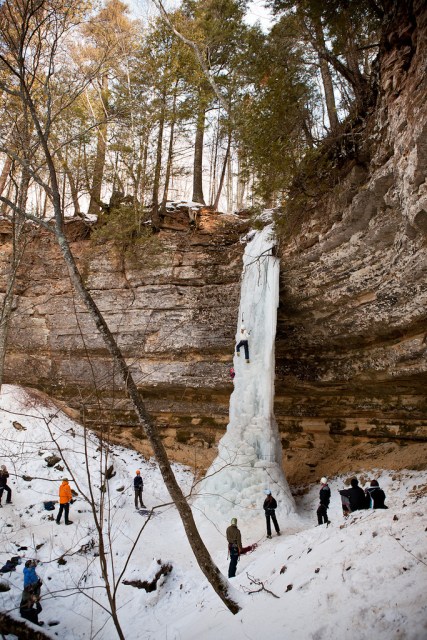
The annual Michigan Ice Fest takes place January 30 – February 2, 2014 in and around Munising. This annual festival takes place the 1st weekend of February every year and gives you a chance to look at and demo the latest and greatest equipment, meet some of the worlds best climbers and see what they’ve climbed all over the world. There’s also climbing socials and even intro to ice climbing classes using the ice climbing paradise that surrounds Munising.

Click the link above and be sure to check out their Michigan Ice Fest photo gallery on Facebook including galleries from 2009, 2010 & 2012 Ice Fests!

As the Ice Fest organizers note, the UP offers as much as 6 months of climbable ice! The Pictured Rocks National Lakeshore Ice Climbing page tells more:

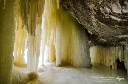
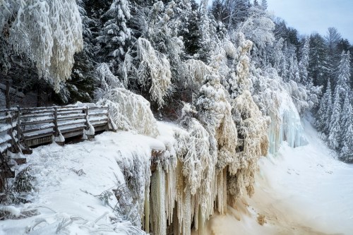
Ice climbing is becoming a popular winter sport at Pictured Rocks National Lakeshore. With ample lake effect snow, numerous waterfalls, porous sandstone cliffs, and the water which seeps out of the rock layers, curtains and columns of ice are common.

Snow and ice are generally present by the second or third week in December and remain until late March. While ice frequently forms along the Pictured Rocks cliffs above Lake Superior, these areas are not recommended for climbing due to hazardous exposure to the lake. The most accessible ice columns are found along the Pictured Rocks escarpment between Munising Falls and Sand Point along Sand Point Road.

Eric took this photo at the Ice Fest in 2012. Check it out bigger and see lots more great shots in his slideshow.

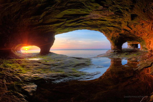
More ice climbing on Michigan in Pictures!

Walking with the Icefoot on Great Lakes beaches

Winter morning on Agate Beach

Winter morning on Agate Beach, photo by Gary of the North(Footsore Fotography)

Ernest W. Marshall talks about a common winter feature along considerable stretches of Great Lakes shorelines, the Icefoot:

Air and water temperatures must be sufficiently low before an icefoot begins to form. The conditions favorable for icefoot formation are broad open shorelines gradually sloping below water level, and facing so that wind-blown spray is carried inland toward the shore to freeze. The character of growth of an icefoot differs during different periods of the winter. During the course of the winter the icefoot may suffer periods of denudation alternating with periods of accretion. The development of an icefoot can be held at one stage by the early freezing of fast ice offshore. An icefoot can be composed of any combination of frozen spray or lake water, snow accumulations, brash, stranded icefloes, and sand which is either thrown up on the icefoot by wave action or is blown out from the exposed beaches.

Observations of the icefoot along the shorelines of Lakes Superior and Erie indicated that the moderately steep portions of the shore were characterized by narrow terraces composed of frozen slush and brash thrown up by storm winds. The outer edge of this icefoot was often cusp-like in form, resulting from the mechanical and melting action of the waves. The inner portions of the cusps acted to concentrate the wave action, forming blowholes which threw spray back on the icefoot.

You can click to read more.

Gary took this photo at one of my favorite places in Michigan: Agate Beach on Lake Superior in Grand Marais, Michigan. In the distance is Grand Sable Dunes and the Pictured Rocks National Lakeshore. View his photo big as Lake Superior and see more in his Grand Marais Michigan slideshow including a shot of a staggeringly huge ice mound!

Lots more Grand Sable Dunes, Pictured Rocks National Lakeshore & winter wallpaper on Michigan in Pictures!

Winter Wonderland at Tahquamenon Falls

winter, upper tahquamenon falls, michigan

winter, upper tahquamenon falls, michigan, photo by twurdemann

twurdemann writes that this winter wonderland at Tahquamenon Falls State Park is created by freezing spray/mist from the adjacent waterfall and that the brown color is from tannins in the water. One second exposure in the Upper Peninsula. View his photo bigger and see more his awesome winter slideshow.

There’s lots more about Michigan’s largest waterfall on Michigan in Pictures!

Pinnacle Falls on the Yellow Dog River

Pinnacle Falls - (Yellow Dog river) - near Big Bay, Michigan

Pinnacle Falls – (Yellow Dog river) – near Big Bay, Michigan, photo by Michigan Nut

The Pinnacle Falls entry at GoWaterfalling.com explains that:

Pinnacle Falls is located on a wild stretch of the Yellow Dog River, roughly 8 miles south west of Big Bay. The Yellow Dog has carved out an impressive gorge that must be around 200 feet deep. The falls is about 25 feet high, and is a steep cascade like many of the falls in the area. The falls is named for the large pinnacle of rock on the right side of the falls.

Read on for comprehensive directions and a map of the many Marquette area waterfalls.

John writes:

This was I think the most remote Michigan waterfall I have been to. The only directions we had was an article written in 2006 from some guy who found it on his mountain bike. He included the GPS way-points but when we reached it there was no falls or trail around. We went down one last two-track with the jeep after trying for a couple of hours, and finally found the trail to the falls. It was about a 25 minute hike. The Yellow Dog has carved out an impressive gorge back there. This would be a great place to pack in and pitch a a tent for a night or two. Very beautiful Waterfall. The photo doesn’t do this area justice.

That’s a pretty deep hole right below the falls, I couldn’t resist stripping down and swimming for awhile. :)

That’s probably ill-advised for today! View John’s photo bigger and see more in his awesome 80+ photo Michigan Waterfalls slideshow.

Many (many) more waterfalls on Michigan in Pictures.

Waterfall Wednesday: Shining Cloud Falls

Shining Cloud Falls

Shining Cloud Falls, photo by Mikeydubz1

GoWaterfalling.com is the premier site for Michigan waterfall information, and they write that Shining Cloud Falls:

…is the largest, and one of the wildest backcountry waterfalls in Porcupine Mountains State Park. You will have to hike at least 5 miles in to see the falls, and another 5 miles to get back. If you are looking for a good long day hike this is a winner. In addition to the main falls there are also a number of smaller cascades, and whatever route you take there is lots of wilderness scenery.

The total drop of the falls is about 20′. The falls consists of two parts, a slide on the left, and a plunge on the right. In higher water the two parts merge, but in lower water the two parts are distinct. Plunge falls are rare around Lake Superior.

They say that the real challenge is reaching this remote fall, but that it’s definitely worth the trip – read on for instructions!

Check Mikey’s photo out bigger and see more in his Porcupine Mountains slideshow.

Many more Michigan waterfalls on Michigan in Pictures!

First Light at Lake of the Clouds

First light

First light, photo by adonyvan

About a month ago, Jiqing Fan spent the night at Lake of the Clouds in the Porcupine Mountain State Park. I featured one of his photos then but I figured after Sunday’s ripping storm, we all deserved a glorious sunrise to start the week!

Check it out bigger and see more in his Houghton & UP MI slideshow.

More sunrises on Michigan in Pictures.

Opening Day 2013: Deer Trail Inn Edition

UP Marenisco Watersmeet MI RPPC 1930s The Deer Trail Inn Saloon & Restaurant DANCING COCKTAILS BEER LUNCHES RED CROWN STANDARD OIL GAS On US-2 Photographer UNK1

Deer Trail Inn Saloon & Restaurant on US-2, photo from UpNorth Memories – Donald (Don) Harrison

Today is Opening Day of the 2013 deer season, and if you’re a hunter I doubt you’re reading this. Almost all of Michigan is potentially open to hunting, so  take extreme care over the two weeks of the November 15-30 Deer Hunting Season.

Confession: I usually root for the deer.

The Toledo Blade reports:

The 2013 “Michigan Deer Hunting Prospects” summary — which is essentially the scouting report on the season – states that deer hunter success in Michigan is sometimes tied to just “being in the right place at the right time,” and that is often the result of being in the field at the peak of whitetail breeding activity. During that fall period, normally ultra cautious bucks will drop their defenses and be on the move much more often.

The state experts say that the 2012 deer season in Michigan was better than the previous year, with hunter success rates showing increases in the Upper Peninsula (UP) and Northern Lower Peninsula (NLP). “Slowly but steadily growing deer populations” in those areas in recent years are credited with improving the harvest.

More than 700,000 deer hunting licenses were purchased in Michigan in 2012, and close to 600,000 hunters took part in the regular firearm season. Overall, deer hunters spent 9.4 million days in the field in Michigan last year, and harvested 418,000 whitetails.

Read on for more and click for the 2013 Michigan Deer Hunting Prospects report.

Check the photo out background big and and check out Don’s massive collection of hunting photos and memorabilia!

Land of the Lost: Central Mine

land of the lost

land of the lost, photo by Marty Hogan

The Keweenaw Historical Society page on Central Mine and Village explains:

One of the most noteworthy historical sites in Keweenaw County is Central, or Central Mine, a village that once was the home for over 1,200 people, and the site of one Keweenaw’s most successful mines. The mine, opened in 1854, produced nearly 52 million pounds of copper by the time it closed in 1898.

Several miners’ homes and buildings still stand on the site. In 1996, the Keweenaw County Historical Society acquired 38 acres of the old Central site. Some of the residences are being restored, and a Visitors Center provides interpretive exhibits not only about the mine but also about the miners’ families, homes, schools and churches.

Click through for maps, photos and more information about Central and other sites.

Marty took this photo in Engine House No.2 at the Central Mining Company in Central, Michigan. He says that from 1875-1898, it housed the Steam Hoist for Shaft No.2. Check it out background bigtacular and see more in his Central, Michigan slideshow.

There’s a whole lot more from Marty and his travels to some of Michigan’s coolest places that once were on Michigan in Pictures!