Some say Masquigon, some say Muskegon

Masquigon

Masquigon, photo by Rudy Malmquist

Wikipedia’s Muskegon entry explains that:

“Muskegon” is derived from the Ottawa Indian term “Masquigon” meaning “marshy river or swamp”. The “Masquigon” river was identified on French maps dating from the late seventeenth century, suggesting that French explorers had reached Michigan’s western coast by that time.

Father Jacques Marquette traveled northward through the area on his fateful trip to St. Ignace in 1675 and a party of French soldiers under La Salle’s lieutenant, Henry de Tonty, passed through the area in 1679.

The earliest known Euro-American resident of the county was Edward Fitzgerald, a fur trader and trapper who first came to the Muskegon area in 1748 and who died here, reportedly being buried in the vicinity of White Lake. Sometime between 1790 and 1800, a French-Canadian trader named Joseph La Framboise established a fur trading post at the mouth of Duck Lake. Between 1810 and 1820, several French Canadian fur traders, including Lamar Andie, Jean Baptiste Recollect, and Pierre Constant had established fur trading posts around Muskegon Lake. In 1830 Muskegon was an Ottawa village.

Euro-American settlement of Muskegon began in earnest in 1837, which coincided with the beginning of the exploitation of the area’s extensive timber resources. The commencement of the lumber industry in 1837 inaugurated what some regard as the most romantic era in the history of the region.

Read on at Wikipedia.

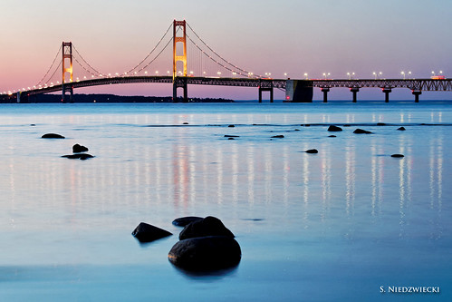
Check this photo out background bigtacular and see more in Rudy’s Neutral Density slideshow. While we’re at Wikipedia…

In photography and optics, a neutral density filter or ND filter is a filter that reduces and/or modifies intensity of all wavelengths or colors of light equally, giving no changes in hue of color rendition. It can be a colorless (clear) or grey filter. The purpose of a standard photographic neutral density filter is to allow the photographer greater flexibility to change the aperture, exposure time and/or motion blur of subject in different situations and atmospheric conditions.

History? Yes, Michigan in Pictures has lots and lots of Michigan history … and a fair bit on Muskegon too!

The Quincy Copper Smelter

Abandoned Quincy Copper Smelter Pano / See the set.

Abandoned Quincy Copper Smelter Pano, photo by Whitney Lake

The Quincy Smelter Association says:

The Quincy Smelter is the only remaining copper smelter in the Lake Superior Region. Built by the Quincy Mining Company, the smelter used heat and chemical processes to turn copper ore into ingots. The ingots were then sold and shipped to factories where they were turned into products such as copper wire or tubing.

From 1898 to 1967 the Quincy Mining Company Smelter at Ripley processed copper, first from its mines and then later from its reclamation plant. The smelter complex is built on the stamp sand of the Pewabic mines’ mill. It continued to melt scrap copper until 1971.

Among the buildings remaining on the site are the three-story blast furnace, built in 1898, with additions in 1904 and again in 1910. The sandstone faced mineral warehouse built in 1904 is reached by a 460-foot trestle. The site also includes three rectangular warehouses, a concrete block briquetting plant built in 1906, a powerhouse, a casting house, carpenter and cooper shop for making barrels, as well as a machine shop, and laboratory.

The Copper Country Explorer has an incredible, multi-part tour of the Quincy Smelter that is rich with history and photography new & old. I can’t recommend that link enough! You can get some interesting stories of life at the smelter and the machines they used from the Quincy Smelter blog. The Keweenaw National Historical Park continues the story in Quincy Smelter Stabilization and Rehabilitation, saying that the smelter is now owned by Franklin Township:

The smelter complex is unique in the country and, perhaps, the world in the number and types of 19th and early 20th century buildings and landscape features that survive.

The continued survival of these structures is tenuous. Preservation of the complex is proving challenging. Since the final shutdown of the smelter in 1971, little has been done to maintain it. Severe winters and neglect have taken a sizeable toll; some buildings have collapsed, others are nearly so. Franklin Township took on the property as a preservation-friendly owner, and has endeavored to find new uses for the historic complex, including simply opening it as a heritage attraction as part of Keweenaw National Historical Park.

They also have a report on conditions at the site and plans for the future (includes a nice map of the site). If you’re interested in Michigan’s mining heritage, the Keweenaw National Historical Park (established 1992) is a relatively new and interesting project of the NPS.

Definitely check this photo out on black and see more in Whitney Lake’s Quincy Smelter / Michigan slideshow.

More from the Keweenaw National Historic Park on Michigan in Pictures.

Aboard the Friends Good Will

P5115272_4639

Untitled, photo by bvriesem

“We have met the enemy and they are ours: Two Ships, two brigs, one schooner and one sloop.”
~United States Commodore Oliver Perry

The sloop was Friends Good Will, captured by the British briefly. The story of the Friends Good Will begins:

Oliver Williams was born in Roxbury, Massachusetts, a village near Boston, in 1774. Undoubtedly, he grew up aware of, and hearing stories about, the birth of his young nation.

Oliver Williams later saw opportunity in the vast Northwest Territory. He opened a dry goods store in Detroit, Michigan Territory, in 1808. The inventory for his store, like nearly all finished goods, came from the east. He made two trips each year, overland. The trips were slow and the resources he expended were never anything more than a continuing drain against whatever profits early businesses in the cash starved frontier would permit.

In 1810, Oliver Williams took a chance. The gamble was not particularly unusual for men of his nature. Men did not conduct business on the frontier without an entrepreneurial instinct. He decided to build a ship. The vessel would use the only “highway” available – Lake Erie; Buffalo to Detroit, non-stop, direct. His inventory would arrive faster, and in greater quantity, and while the vessel was a substantial capital outlay, she would sail for years and could earn money by shipping goods the length of each shipping season. Other vessels plying the Lakes were finding cargoes and the steady stream of settlers assured volumes of cargo and demand for the ship would only grow with each coming season.

Oliver Williams built his ship at the River Rouge, on the banks of the Detroit River. A private shipyard was laid out adjacent to the Federal yard, where the army transport snow Adams, the only government vessel on the upper Lakes, was built years before. Other ships sailed past while this new vessel took shape, the schooners Salina and Ellen and the sloop Contractor. The sight of each of them only encouraged Oliver Williams. His idea had merit; his gamble would pay.

The new ship slid down the ways, in early 1811. He christened her Friends Good Will. While no one knows for certain the origin of the name, a coincidence seems too obvious to ignore. The name may well have been in honor of an earlier Friends Good Will, which transported the first wave of Irish immigrants from Larne to Boston in 1717. It is likely Oliver Williams knew her story and borrowed her name. His vessel, he likely hoped, would also bring waves of settlers to a new land of opportunity ­ the Michigan Territory.

Read on for much more of the story of the remarkable story of the Friends Good Will including her capture by the British and subsequent adventures. See a video right here and definitely visit the Michigan Maritime Museum, online and when you’re South Haven for much more of Michigan’s maritime history.

Check this out background big and take a trip in Bill’s May 2012 Aboard the Friends Good Will slideshow.

The Mackinac Bridge takes center stage on Labor Day

Bridge at Twilight 1562-12

Bridge at Twilight 1562-12, photo by StacyN – MichiganMoments

Right now thousands of people are participating in the Mackinac Bridge Walk, an Michigan tradition that began on Labor Day of 1958 and has continued every year since then. While just 68 people made that first walk, it now averages over 50,000 people. You can tune in for some shots from the Mackinac Bridge Cam and see one from this morning on the Michigan in Pictures Facebook.

If you’d like a little Labor Day reading, I heartily recommend How Labor Won Its Day from the Detroit News Rearview Mirror.

See Stacy’s photo bigger and see some more cool shots of this Michigan icon in her Mackinac Bridge slideshow.

Much (much) more about the Mackinac Bridge on Michigan in Pictures!

What’s in a Name? Tahquamenon Falls edition

Tahquamenon Falls

Tahquamenon Falls, photo by AndrewH324

We’ll close out Waterfall Week on Michigan in Pictures with this photo that has been the cover photo on the Absolute Michigan Facebook all week. Here’s hoping that you get a chance to enjoy one of Michigan’s nearly 200 waterfalls soon!

With a drop of nearly 50 feet, a width of over 200 feet and a maximum flow of more than 50,000 gallons of water, the Upper Tahquamenon Falls are one of the largest waterfalls east of the Mississippi. Pronounced about how it looks – like “phenomenon,” the falls gained fame way back in 1856 in Henry Wadsworth Longfellow’s Song of Hiawatha:

Lay aside your cloak, O Birch-tree! lay aside your white-skin wrapper,
For the Summer-time is coming, and the sun is warm in heaven,
And you need no white-skin wrapper!” thus aloud cried Hiawatha
In the solitary forest, by the rushing Taquamenaw

A feature back in 2006 from the Chicago Tribune offers one popular theory for the name:

The river and its two falls (the smaller Lower Falls are further downstream) are located in the northeast part of Michigan’s Upper Peninsula, just miles from Lake Superior, in the 46,000-acre Tahquamenon Falls State Park. The Upper Falls is one of the largest waterfalls this side of the Mississippi in the United States. (Niagara–shared with Canada–is the largest.)The park is dense with both hardwoods and pine and filled with wildlife. Sightings of moose, gray wolves, black bears, American martens and river otters are typical, and have always been an attraction for nature lovers–including Henry Wadsworth Longfellow, whose poem about this area recounts how Hiawatha built his canoe “by the rushing Tahquamenaw.” The spelling was a variation of Tahquamenon, which comes from an Ojibwa word meaning “dark berry.”

Origins of the Name from the Michigan DNR suggests an alternative root of the name:

The word Tahquamenon has not been as easy to trace. There have been many theories to the origins of this name, such as the color of the water of the Tahquamenon River or meaning the place of the blueberry swamps.

In his book, “Lake Superior Place Names: From Bawating to the Montreal,” Dr. Bernard C. Peters sheds additional light on the subject. Peters suggests the word Tahquamenon comes from the word Outakouaminan, which appears on a 1671 Jesuit map. The key is its location on the map. Because it is shown near an island in what now is Whitefish Bay, Peters believes the name actually refers to a shortcut across the bay.

Wherever the name came from, there’s no doubt that this is a “can’t miss” waterfall. You can get the 411 on Tahquamenon Falls at Go Waterfalling.com and see a video of the case for the falls as one of the Seven Wonders of Michigan. Also check out this great video of the falls from 1950 and see a cool old photo of the falls right here.

Check this photo out background bigtacular and in Andrew’s Upper Peninsula slideshow.

Lots more Tahquamenon Falls on Michigan in Pictures.

Unchaining a River: Restoring the Boardman River

Poetry of Nature, photo by Mark Lindsey

“We’re healing one of Mother Earth’s arteries. I think she’s been hurting for a long time.”
~Hank Bailey, Grand Traverse Band Natural Resources Official

The Boardman River watershed encompasses 291 square miles and flows 179 miles from its origin in Kalkaska County to West Grand Traverse Bay in Traverse City. Last Wednesday, the process of removing three no longer used hydro-electric dams from the Boardman began at Brown Bridge Dam. The removal of the three Boardman River dams (Brown Bridge, Sabin & Boarman) will be the largest dam removal project in Michigan’s history, and the largest wetlands restoration in the Great Lakes Basin. It will allow the Boardman to return to a more natural state as a free-flowing, cold-water river. You can read all about the dam removal on the Boardman River website which explains:

The Boardman River was formed after the last retreat of glaciers covering Northern Michigan approximately 10,000 years ago. The proto-Boardman River was a tributary of the Manistee River and flowed south to Lake Michigan. The course of the river changed as early headwaters streams cut through glacial deposits and joined with the proto-Boardman River. This allowed the Boardman River to flow north and empty into Grand Traverse Bay. Glacial deposits, in particular the Kalkaska series soil, are responsible for the high quality of the Boardman River.

…Americans living in the area knew the River by another name. They valued the river as an important transportation route as well as a source of sustenance. Early European settlers called the river the “Ottawa” after the local band of Native Americans. Things changed when Captain Harry Boardman came to the area around 1848, established a sawmill, and acquired timber rights for the area. Captain Boardman stored logs for his sawmill in a natural lake on the Ottawa River, which became known as “Boardman’s Lake.” In time, the entire river became known as the “Boardman River.” In 1852 Captain Boardman sold his timber rights to the real timber barons of time, Perry Hanna & Tracy Lay. The Boardman River played a vital role in the economic growth of the region as it was cleared of debris in order to drive logs downriver to the mills. This process fueled a growing city but was devastating to the river’s aquatic habitat, contributing to the extirpation of Michigan Grayling in the river. After the logging era, several dams were constructed to provide power for the growing needs of Traverse City. These hydroelectric dams originally supplied a large percentage of the city’s electrical needs, but this declined over time. Before being decommissioned in 2005, these dams only provided 3.4% of the power used by Traverse City Light & Power customers each year.

Of approximately 179 miles of stream in the Boardman River Watershed, 36 are designated as “Blue Ribbon” trout habitat. These areas, located upstream of the Beitner Road crossing are premier fish habitat and important to anglers. Boardman River anglers have an important economic impact on the region. The entire watershed is also used for activities such as canoeing, tubing, kayaking, hiking, hunting, and bird watching. These uses make it a destination for an estimated 2 million Recreational User Days annually.

This project seems to me to be an excellent example of “government done right” – an adequately funded effort that leverages a wide range of scientific experts to protect property owners while restoring a natural resource to its natural state. There’s also a Boardman River Prosperity Plan that will seek to turn a solid environmental decision into a sound economic one was well.

Also see this feature on IPR News Radio and a cool video about the dam removals produced for The Grand Vision Natural Resource Network by Miles Chisholm of the Grand Traverse Band of Ottawa and Chippewa Indians. The video includes some great old photos of activity on the river.

Mark took this photo in October 2010 when the colors were callin’ – see it on black and see more in his Explored slideshow.

Downtown Synagogue of Detroit

An Amassment of Colors

An Amassment of Colors, photo by DetroitDerek Photography

The Isaac Agree Downtown Synagogue (of Detroit) explains that:

The Isaac Agree Downtown Synagogue (IADS) was established in 1921, at a time when there were many synagogues located in Detroit. Its principal mission was to address the unmet needs of the Jewish community ― particularly for those who worked downtown, were unaffiliated with another synagogue, or were visiting the city―by providing a traditional (Conservative) Jewish presence in the heart of Detroit.

…As much of the Jewish community migrated to suburban Detroit, the IADS―like the city itself―has suffered from a shrinking population and a depletion of resources. In recent years, daily services have, of necessity, been eliminated. However, the Downtown Synagogue proudly continues to offer weekly Sabbath services, as well as High-Holiday services, the latter of which attracts hundreds of worshippers.

The Synagogue is currently housed in a historic four-story building, a building that it has occupied and owned since the early 1960s. Located at 1457 Griswold Street, it is well situated, but is in serious need of major repair. Currently, parts of it are unusable. However, the unique triangular design creates an uncomparable, interesting space. The potential for this building is far from being realized.

This Sunday (August 19), they are offering J-Cycle, a bicycle tour of historic Jewish Detroit. A portion of the proceeds will be donated to the Back Alley Bike Project, at the Hub of Detroit, a non-profit organization providing cycling education and services with a focus on youth development, sustainable practices and community access.

See Derek’s photo on black and in his massive and amazing Detroit slideshow.

Also see a few more pics from the Absolute Michigan pool.

Comerica Park, home of the Detroit Tigers

Tigers Game_2012-07-21_15-08-05_P7210017_©MikeBoening_2012_HDR (1)

Tigers Game, July 21, 2012, photo by memories_by_mike

It may come as a surprise to regular readers that despite all the posts about the Detroit Tigers here and at Absolute Michigan, I’ve never been to Comerica Park. Today I not only get to go – I get to sit on the 3rd base line (2nd row!!)as the red-hot Detroit Tigers face the New York Yankees tonight!

Wikipedia’s entry for Comerica Park (edited a bit by me) explains that:

Groundbreaking for a new ballpark to replace Tiger Stadium for the Tigers was held on October 29, 1997 and the new stadium was opened to the public in 2000. In December 1998, Comerica Bank agreed to pay $66 million over 30 years for the naming rights for the new ballpark. Comerica Park sits on the original site of the Detroit College of Law.

In contrast to Tiger Stadium, which had long been considered one of the most hitter-friendly parks in baseball, Comerica Park is considered to be extremely friendly to pitchers. Except for dead center – 420 feet versus Tiger Stadium’s 440 feet – the outfield dimensions were more expansive than those at Tiger Stadium. This led to complaints from players and fans alike, and engendered the sarcastic nickname Comerica National Park.

Although a few public figures—notably radio announcer Ernie Harwell—supported the dimensions, most agreed that the left-field wall, in particular, needed to be brought closer to home plate. Before the 2003 MLB season the club did so, moving the distance from left-center field from 395 to 370 feet. In place of the old bullpens in right field, 950 seats were added for a new capacity of 41,070.

At the time of construction, the scoreboard in left field was the largest in Major League Baseball. The first playoff game at Comerica was played on October 6, 2006 against the New York Yankees. It hosted its first World Series later that month. The stadium also includes many baseball-themed features, including a “Monument Park” in the deep center field stands, complete with statues of former Tigers Ty Cobb, Hal Newhouser, Charlie Gehringer, Hank Greenberg, Al Kaline, and Willie Horton.

A few neat things I found are Comerica Park from Ballparks.com, baseball writer Geoff Baker touring Comerica,  Calvin Johnson hitting a HR in BP, Comerica on Michigan in Pictures, a time-lapse of the installation of the new high-def scoreboard, the slightly bizarre Comerica UFO footage and a very cool RC plane fly-over of Comerica.

Check this photo out big as a ballpark and in Mike’s slideshow.

The Beauty of Lake Charlevoix

Lake Charlevoix Yacht Race

Lake Charlevoix Yacht Race, photo by Innerspacealien

Last week USA Today released their list of the best lakes in America. The Great Lakes were not eligible and Lake Tahoe was the winner, but Lake Charlevoix in Northern Michigan managed to grab the runner-up spot. Click that link to read what some of their readers wrote. The Lake Charlevoix Lake Association says:

Lake Charlevoix is the third largest lake in the state with a surface area of over 17,200 acres and approximately 60 miles of shoreline. The maximum depth in the main basin is 122 feet and in the south arm, 58 feet. It is located at 45 degrees north latitude and 85 degrees west longitude. It has direct access to Lake Michigan via dredged channels in and out of Round Lake in the city of Charlevoix. There are close to 1,700 lots on the lake, with approximately 1,200 different owners. The lake is usually frozen for about three months of the year from near the end of January to early April.

There are three cities at the ends of the lake. Boyne City is at the east end of the main lake and is a historic lumber and tannery town. It is now a year round recreation center with the lake in the summer and Boyne Mountain ski resort in the winter. East Jordan is at end of the south arm and was also important in lumbering in the nineteenth century as well has having a large iron works that is still there today. The city of Charlevoix is at the mouth of the lake and is both a historic and present day resort town.

The city of Charlevoix is named after Pierre François Xavier de Charlevoix, a French explorer who traveled the Great Lakes and was said to have stayed the night on nearby Fisherman’s Island one night during a harsh storm. Lake Charlevoix had been named “Pine Lake” until 1926 when it was decided to change the name because, among other reasons, most of the pines had been harvested in the previous century and there were 25 other lakes in Michigan with that name.

They also have some great historic photos you can check out.

See Craig’s photo background big and see more photos from the area in his Up North slideshow.

More great Michigan lakes on Michigan in Pictures!

How Alpena got its name

Brick Thunder

Brick Thunder, photo by cmu chem prof

The Pure Michigan Blog has an excellent series on how Michigan cities got their names. They are up to Part 10. One of the cities is Alpena:

Alpena

Alpena County was first named “An-a-ma-kee,” or “Thunder,” in honor of an old Chippewa chief of the Thunder Bay band who had signed a treaty negotiated with Henry Schoolcraft in 1826. After studying the Indian legends around the word “An-a-ma-kee” (or Animikee), Henry Schoolcraft concluded that the name was not completely appropriate. Then he manufactured the name Alpena from “Al,” an Indian syllable meaning “the”, and either “pinai,” an Arabic word meaning “partridge,” or “peanaisse,” an old French word meaning “bird.”

Check this photo out background big and in Phil’s huge Cities & Towns slideshow.