The Sanilac Petroglyphs

Sanilac Petroglyphs

Sanilac Petroglyphs, photo by Leon Baker

M. Rebekah Otto of Atlas Obscura has an article about the Sanilac Petroglyphs:

The drawings were carved into the sandstone in Sanilac County but remained hidden by dense forests until the devastating fire exposed them.

The glyphs are carved into a large rock on the ground that is forty feet long and fifteen feet wide. Carved between 300 and 1,000 years ago, the drawings were likely made by the Hopewell or Chippewa Indians. They depict flying birds, other animals, and a man with a bow and arrow – lasting testaments to a former way of life.

Archaeologists have not determined the purpose or use of the drawings, though some have speculated that they were a destination for vision quests, as the rock is isolated near the fork in river. Shaman and holy men may have used the rock as a record of their visions, depicting animals that came to them in dreams.

Today the site is often closed to the public because the soft sandstone erodes easily and the figures are slowly fading away. Call the Sanilac Petroglyphs State Historic Park to get access before visiting.

Read on for more, visit the Sanilac Petroglyph State Historic Park website at the State of Michigan, and also check out this 2011 Detroit News article about the difficulty of preserving this unique bit of Michigan history.

Leon writes that the holes are from stolen petroglyphs. View his photo bigger and see more in his slideshow.

#TBT: Tahquamenon Falls Aerial View, postmarked 1948

Newberry MI UP RPPC Aerial View Upper Tahquamenon Falls near Whitefish Point LL Cook K-498 Postmarked 1948

Aerial View Upper Tahquamenon Fall, Postmarked 1948, photo by Don…The UpNorth Memories Guy… Harrison

In honor of the latest kayaker to throw caution to the wind (or is that water?) and take the plunge over the 51′ Tahquamenon Falls, here’s a cool aerial of the Falls that was postmarked in 1948 and probably taken a few years before.

If you want to see how to do this, check out a great video feature at YooperSteez on How to Kayak Over Tahquamenon Falls with Brazilian extreme kayaker Marcelo Galizio. Things To Do in the UP has an interview with Marcello as well. NOTE: I’m pretty sure this is against the rules at Tahquamenon Falls State Park and probably a great way to kill yourself if you don’t know what you’re doing!

View Don’s photo big as the Falls and see more pics & postcards from Tahquamenon and also follow him at UpNorthMemories on Facebook.

Lots more about Tahquamenon Falls on Michigan in Pictures!


Edison Sault Hydroelectric Plant

Sault Ste Marie Edison Water Treatment  Plant

Sault Ste Marie Edison Water Treatment Plant, photo by Matt

Matt linked over to Top Plants: Edison Sault Hydroelectric Plant Sault Ste. Marie, Michigan in PowerMag, which says (in part):

Hydroelectric projects are unique in that as long as the water is flowing and the mechanicals are periodically upgraded, there are few reasons their turbines won’t continue making electricity into the next century. The energy source may be renewable, but so is the plant itself. An exceptional example is Michigan’s 107-year-old Edison Sault Hydroelectric Plant, which combines historic architecture with modern technology to successfully generate 25 to 30 MW of electricity when operating at full load.

…Excavation of the hydropower plant’s canal began in September 1898 and was completed in 1902. Concurrently, construction of the Edison Sault Electric Hydroelectric Plant began in March 1900 and was completed in 1902. Official opening of the facility was held on October 25, 1902. At the time of completion, the plant was second only to Niagara Falls in terms of hydro development.

The facility is constructed of stone and steel. Much of the stone that was used was excavated from the power canal during its construction. Additional stone was used on other local landmarks throughout the City of Sault Ste. Marie.

You can read on for more (including diagrams) and visit the Cloverland Electric Cooperative Hydroelectric Plant page for more!

View Matt’s photo background bigtacular and see more in his Michigan Vacation slideshow. Speaking as someone who’s seen a fair amount of Michigan vacation photos – nice vacation Matt!!

More from Sault Ste. Marie on Michigan in Pictures!

Mackinac’s Round Island Passage Light is for sale

Somewhere in Light

Somewhere in Light, photo by Kristina Austin Scarcelli

mLive reports that the Government Services Administration is taking bids from nonprofit or community groups to take stewardship of the Round Island Passage Light before auctioning it off. Click through for all the details.

Lighthouse Friends has a page on the Round Island Passage Lighthouse that includes the entry from the 1948 Coast Guard Bulletin on this light that replaced the Round Island Lighthouse (in the background on the left):

The substructure of the new lighthouse, 56 feet square up to the 1 foot line below mean low water, is a timber crib with cells at the perimeter filled with concrete and internal cells filled with 5-inch to 14-inch rock. The superstructure is concrete with a reinforced concrete deck. It has four vertical and four sloping sides, giving the lighthouse a new and unusually trim appearance. The tower is appropriately ornamented on each side with a 4- or 5-foot Indian Head plaque, symbolic of the area.

But the most interesting thing about Round Island Passage Light Station is its main light. Located in the top section of the 41 ½-foot tower, it is indeed a departure from the “single light source” arrangement that has been in use for centuries. This new light apparatus is a solid bank of sealed beam lamps of 3,000 candlepower which produce a characteristic of occulting green every 10 seconds. It is visible 16 miles. (These sealed beam lamps are similar to your present day automobile headlights.)

The fog signal consists of two air operated diaphragm horns, sounding simultaneously with 3 seconds blast and 27 seconds silence. The radiobeacon is class B. Distance finding is also provided.

The passage between Mackinac Island and Round Island has long been regarded as extremely hazardous. It is now adequately guarded by Round Island Passage Light Station. This will result in a saving of time on trips and will relieve the congestion of Poe Reef Channel. This, in turn, will increase Great Lakes’ tonnage.

View Kristina’s photo bigger and see more in her Michigan Lighthouses slideshow.

TBT: Spikehorn Meyers and His Bears

Clare Harrison MI Spikehorn Meyers Clare County MI RPPC 1930's-40's M77

Clare Harrison MI Spikehorn Meyers Clare County MI, photo by Don…The UpNorth Memories Guy

Here’s a Throwback Thursday featuring one of Northern Michigan’s most colorful characters:

Harrison’s most colorful character was John “Spikehorn” Meyers, known to thousands of Michigan residents simply as Spikehorn. He was a showman, naturalist, politician, coal miner, tile manufacturer, furniture builder, inventor, realtor, bear hunter, lumberjack, and above all, individualist. The old gentleman had a fertile imagination under his white thatch of hair and full white beard.

According to neighbors, Spikehorn’s interest in the woods and buckskins developed around 1930, when he opened his Bear and Deer Park established on his property at the corner of US-27 and M-61. Rumor has it the park even contained an occasional buffalo.

Spikehorn and his friend, Red Eagle, dressed in buckskins for tourists and treated them to tales of their adventures in the woods. He enjoyed feeding his pets sweets, popcorn, and pop and loved posing with his deer and bears for cameras.

His enemies were the Conservation Officers, as indicated by the sign in front of his business: “Feed Conservation Officers to the Bear.”

Spikehorn also appears in one of the best Michigan history videos, Roaming Through Michigan, a classic newsreel.

View John’s photo big as a bear and see more in his Spikehorn Meyers & Harrison MI slideshow.

Tons more history and more roadside attractions on Michigan in Pictures!

Point of Origin

The Heart of Detroit

The Heart of Detroit, photo by Maia C

The Point of Origin is located in Campus Martius Park in downtown Detroit. The park’s website explains:

In 1788, Campus Martius served as a drill ground for militia training. Campus Martius means “military ground” and was named after the Campus Martius at Marietta, Ohio, a 180-foot stockade.

After the fire of 1805, Judge Woodward was appointed to oversee the plan to lay out the streets, squares and lots with the assistance of the best surveyors from Canada. They placed their instruments and astronomical devices on the summit of a huge stone. He viewed the planets and meteors in order to determine “true North”. Today we still call this point the “Point of Origin” which is located in center of Campus Martius at the junction of Woodward and Monroe. It is from this point that the City of Detroit’s Coordinate system was created.

FYI, this photo appeared on Rolling Past 5000 on Michigan in Pictures, but only in a bit part as one of the zeros!

View Maia’s photo bigger and see more in her Downtown Detroit slideshow.

The Making of the Mackinac Bridge

Bridge_HDR2.jpg

Bridge HDR 2, photo by Allison Hopersberger

A calm night on the Straits of Mackinac, and Michigan’s signature bridge was looking fine!

I’ve posted a ton about the Mighty Mackinac Bridge here on Michigan in Pictures, but had never seen this excellent summary of how it came to be courtesy the Michigan Dept. of Transportation’s page on I-75 and the Straits of Mackinac:

The five-mile stretch of water separating Michigan’s two peninsulas, the result of glacial action some twelve thousand years ago, has long served as a major barrier to the movement of people and goods. The three railroads that reached the Straits of Mackinac in the early 1880s, the Michigan Central and the Grand Rapids & Indiana Railway from the south, and the Detroit, Mackinac and Marquette from the north, jointly established the Mackinac Transportation Company in 1881 to operate a railroad car ferry service across the straits. The railroads and their shipping lines developed Mackinac Island into a major vacation destination in the 1880s.

Improved highways along the eastern shores of Michigan’s lower peninsula brought increased automobile traffic to the straits region starting in the 1910s. The state of Michigan initiated an automobile ferry service between St. Ignace and Mackinaw City in 1923 and eventually operated eight ferry boats. In peak travel periods, particularly during deer season, five mile backups and delays of four hours or longer became common at the state docks at Mackinaw City and St. Ignace.

With increased public pressure to break this bottleneck, the Michigan legislature established a Mackinac Straits Bridge Authority in 1934, with the power to issue bonds for bridge construction. The bridge authority supported a proposal first developed in 1921 by Charles Evan Fowler, the bridge engineer who had previously promoted a Detroit-Windsor bridge. Fowler’s plans called for an island-hopping route from the city of Cheboygan to Bois Blanc, Round, and Mackinac islands, thence to St. Ignace, along a twenty-four-mile route. The Public Works Administration flatly rejected a request for loans and grants to implement this project.

A plan was then drawn up for a direct crossing from Mackinaw City to St. Ignace, but they were again denied funds. In 1940, a plan was submitted for a suspension bridge with a main span of 4600 feet. This design was a larger version of the ill-fated Tacoma Narrows Bridge in Washington State, a structure destroyed by high winds on November 7, 1940. Although the disaster delayed any further action, the activities of 1938-1940 nevertheless produced some important results. The bridge authority conducted a series of soundings and borings across the straits and built a causeway extending out 4200 feet from the St. Ignace shore. The Second World War ended any additional work, and the Legislature abolished the bridge authority in 1947.

William Stewart Woodfill, president of the Grand Hotel on Mackinac Island, almost singlehandedly resuscitated the dream of a bridge across the Straits of Mackinac. Woodfill formed the statewide Mackinac Bridge Citizens Committee in 1949 to lobby for a new bridge authority, which the legislature created in 1950. A panel of three prominent engineers conducted a feasibility study and made recommendations to the bridge authority on the location, structure, and design of the bridge.

The State Highway Department, which had just placed a $4.5 million ferryboat, Vacationland, into service at the straits in January 1952, remained hostile to the bridge plan. In April 1952, the Michigan legislature authorized the bridge authority to issue bonds for the project, choose an engineer, and proceed with construction. The authority selected David B. Steinman as the chief engineer in January 1953 and tried unsuccessfully to sell the bridge bonds in April 1953, but by the end of the year, the authority had sold the $99.8 million in revenue bonds needed to begin construction.

View Allison’s photo bigger and see LOTS more in her Mackinac Island slideshow!

Just Great Movies: the Traverse City Film Festival turns 10

Traverse City Film Festival 2005

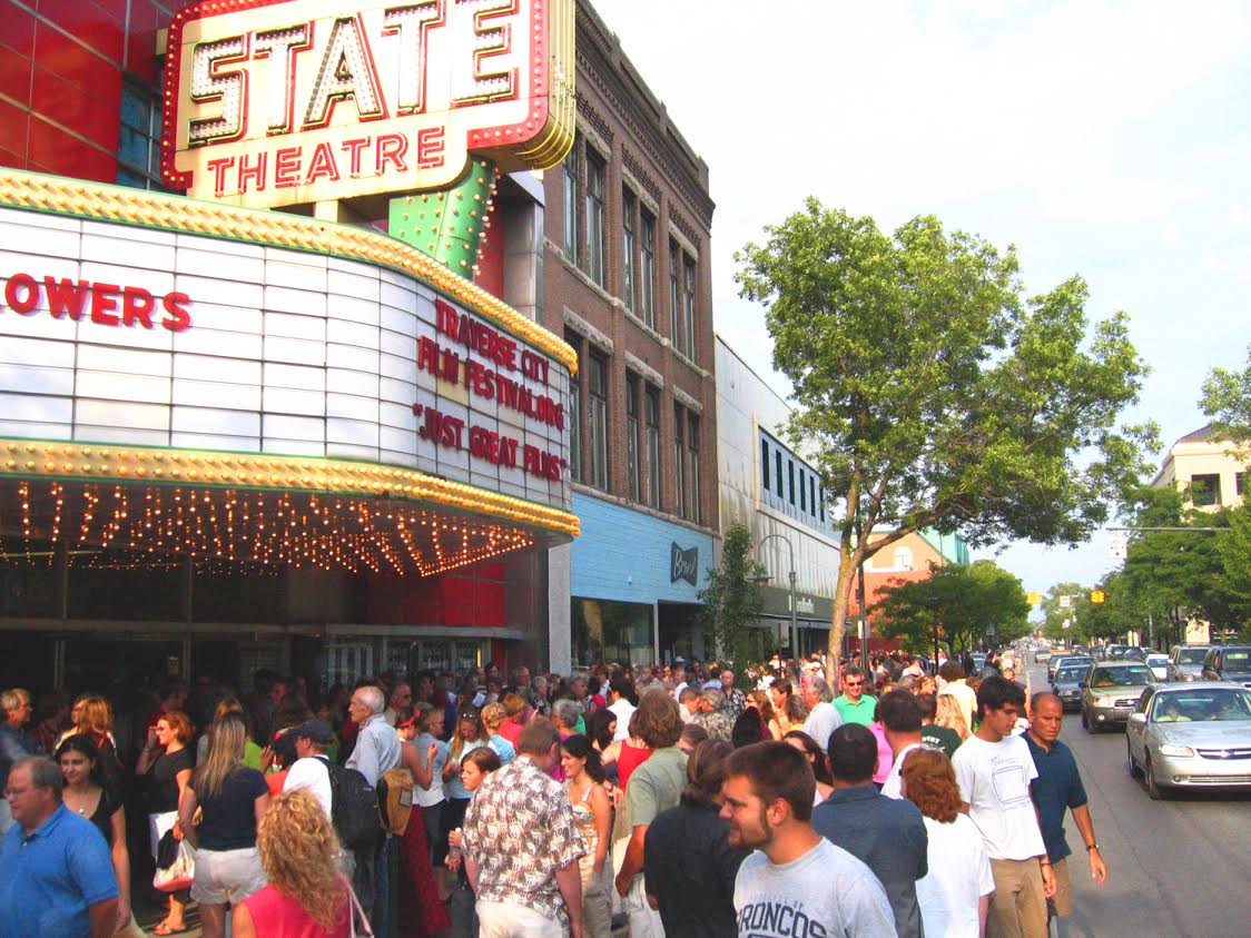
2005 Traverse City Film Festival, photo by John Robert Williams

There were hundreds and hundreds of thousands of dollars of materials that were donated by the community. It was a miraculous, Herculean feat. So cool to be a part of that. We had three meals a day for 35 to 40 people, donated from area restaurants for six weeks, every single day. And they’d drop it off. That’s how supported this thing was. The air was bristling with excitement for this thing and it was really, really cool. It was really cool to be a part of it.
~first-year volunteer Timothy “The Phantom of the State” Grey

I’ve been helping the Traverse City Film Festival (TCFF) with their online media since my offer of assistance to festival co-founder Michael Moore after a film at the State Theatre that first year. The State was where I saw Star Wars, and the theater we all grew up with in Traverse City. It had lain empty for years, but Michael and company led a community effort that got the State open for that first festival and ultimately opened it for real. The transformation that this has wrought on downtown Traverse City can’t be overstated. As one of the most successful theaters of its kind in the nation, the State draws thousands of people downtown for movies every week. They stay to shop & dine and these film patrons are arguably the single greatest factor in Traverse City’s renaissance.

The State is also the home of TCFF which will draw tens of thousands of people to Traverse City for the 10th annual Traverse City Film Festival July 29 – August 3rd and sell over 100,000 tickets to 200+ films. As any TC business owner can attest, it’s a beautiful thing. The Northern Express has a feature this week titled A Traverse City Film Festival Oral History that tells the story of the founding through the memories of the people who were there. Despite the fact that Michael Moore was involved, it’s not a story of politics, but rather of a community working together to realize a dream. Here’s a few highlights:

Co-founder Michael Moore: The lunch began with deciding, ‘Let’s do this.’ And, ‘How are we going to do it?’ And I said, ‘You know, we could start out very small, like really just do it in somebody’s backyard. Or we could do it in a barn. I’m doing it for whatever you guys think we can do.’ By the end of the lunch we all got kind of excited about the possibilities of it all… By the end of it I think we decided that we would try to get like two or three venues — we talked about the Old Town Playhouse; we talked about the Opera House. We brought up the State Theatre but we were told that was not possible … I walked out of there and I was crossing the street, crossing Front Street there by Amical, and I turned and I looked at the State Theatre and I said, ‘Why can’t we use the State Theatre?’ and then I think John said, ‘Well, Rotary owns it now. It’s all closed up and it hasn’t been functioning in years and there’s no real projector there or anything. It’s just an empty building.’

Co-founder Doug Stanton: The defining image for me of the founding of the Traverse City Film Festival is a mason who showed up on his own, without being asked by anyone, to help restore the theater. I wish I could remember his name. His first name was Delbert. He was down on his hands and knees with a toothpick restoring the destroyed tile floor of the State Theatre lobby. He loved the the idea of this new festival so much. That embodied for me the community-driven heart of the whole enterprise. Its founding values to me are not driven by one person at all, but by a community.

Co-founder John Robert Williams: The night that we got the big screw-in fuses and the big push-in fuses from the ‘40s, the night we got through the breakers and made the marquee light up, and only half the neon came on — it’s actually an electrical motor that spins to make those chasers all blink around — we got that thing spinning, and we’re standing out there on a hot, early July night, it was just after the Cherry Festival, we got the lights going on the State Theatre and the cars were honking and people were jumping out of their cars taking pictures. It was like, ‘Oh my God, the lights are on at the State Theatre!’ Because they hadn’t been on in years. That was the pivotal moment for downtown Traverse City.

Williams: Our opening night was a movie called Mad Hot Ballroom. We had this movie about these fifth graders ballroom dancing and learning this in New York City. Mike came up with this little plan… When the credit crawl started rolling at the end of the movie, we were going to switch over to this hot salsa music. We got the approval from the director to switch into some dance music, and so when Michael comes popping up out of the corner at the State Theatre, ‘Ladies and gentlemen, from P.S. 136,’ and he starts naming the kids’ names, and we switch over to the salsa music and here are the cast calls in black background and white type, and these kids come out and dance the winning dance, right in front of the audience. They convulsed. This entire audience came out of their seats as one. I mean the air pressure changed in the room. Whoomp. After Mad Hot Ballroom on that Wednesday night, ticket sales went nuts the next morning because everybody in town was talking to everybody else saying, ‘You can’t believe what these guys did.’

Lots more at the Express with Part 2 coming next week.

View John’s photo from the first TCFF bigger, see his work at his website and definitely check out the Traverse City Film Festival on Flickr for a ton more photos!

PS: Here’s my favorite piece of media we’ve ever created at TCFF, Song to Cinema. It’s well worth your time…

The Dunesmobiles by Phil Balyeat

The Dunesmobiles

The Dunesmobiles, by  Phil Balyeat

Don Harrison operates UpNorth Memories and shares many of the historical post card photos I feature on Michigan in Pictures. Yesterday in honor of photographer Phil Balyeat’s 99th birthday he posted an incredible collection of photos Phil had taken over the years from the Traverse City area including this one.

View Phil’s photo bigger on Facebook and see LOTS more via UpNorth Memories  here, here and here!

More about the Dunesmobiles at Leelanau.com!

#TBT: Midnight at the Burt Lake Scenic Tower

Cheboygan Indian River MI The Burt Lake Scenic Tower at Night This Tower had an early Carl Zeiss 42 Power Telescope for patrons to use, which was a very big deal

The Burt Lake Scenic Tower at Night, photo by Don…The UpNorth Memories Guy… Harrison

I am officially giving in to the TBT (ThrowBack Thursday) meme. I love history too much to let everyone else have all the fun…

Don writes that Burt Lake Scenic Tower had an early Carl Zeiss 42 Power Telescope for patrons to use, which was a very big deal at the time. See it big as a tower and see more in Don’s massive Photo Tribute to Michigan Historian Dave Tinder slideshow.

If you know anything more about it, please share in the comments!

More history on Michigan in Pictures.