Tahquamenon Falls Thursday

Tahquamenon Falls Thursday

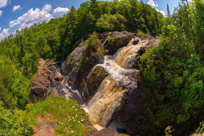
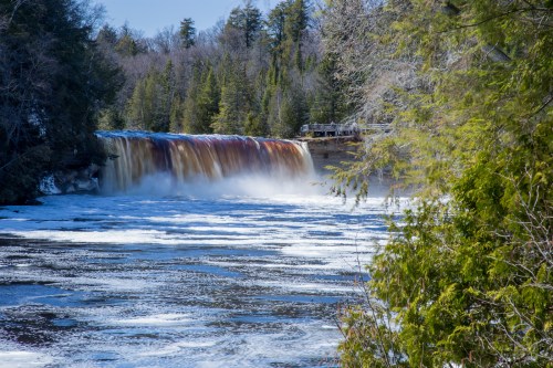
Tahquamenon Falls, photo by Charles Bohnam

The Tahquamenon Falls State Park page says:

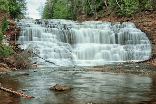
Tahquamenon Falls State Park encompasses close to 50,000 acres stretching over 13 miles. Most of this is undeveloped woodland without roads, buildings or power lines. The centerpiece of the park, and the very reason for its existence, is the Tahquamenon River with its waterfalls. The Upper Falls is one the largest waterfalls east of the Mississippi. It has a drop of nearly 50 feet and is more than 200 feet across. A maximum flow of more than 50,000 gallons of water per second has been recorded cascading over these falls. Four miles downstream is the Lower Falls, a series of five smaller falls cascading around an island. Although not as dramatic as the Upper Falls, they are equally magnificent. The falls can be viewed from the river bank or from the island, which can be reached by rowboat rented from a park concession. The island walk affords a view of the falls in the south channel.

This is the land of Longfellow’s Hiawatha – “by the rushing Tahquamenaw” Hiawatha built his canoe. Long before the white man set eyes on the river, the abundance of fish in its waters and animals along its shores attracted the Ojibwa Indians, who camped, farmed, fished and trapped along its banks. In the late 1800’s came the lumber barons and the river carried their logs by the millions to the mills. Lumberjacks, who harvested the tall timber, were among the first permanent white settlers in the area.

Rising from springs north of McMillan, the Tahquamenon River drains the watershed of an area of more than 790 square miles. From its source, it meanders 94 miles before emptying into Whitefish Bay. The amber color of the water is caused by tannins leached from the Cedar, Spruce and Hemlock in the swamps drained by the river. The extremely soft water churned by the action of the falls causes the large amounts of foam, which has been the trademark of the Tahquamenon since the days of the voyager.

Click through for maps, photos & more.

View Charles’s photo background bigtacular (really – do it!) and click more of his waterfall photos.

Lots more Tahquamenon Falls on Michigan in Pictures and (just found it) waterfall wallpaper. :)


Waterfall Wednesday: Spray Falls

Spray Falls in the Pictured Rocks

Spray Falls, photo by David Juckett

Go Waterfalling’s page on Spray Falls begins:

Spray Falls is the remotest, and perhaps the most impressive of the several waterfalls in Pictured Rocks National Lakeshore. The 70′ waterfall plunges over the cliffs at Pictured Rocks and lands directly in Lake Superior.

The falls is right on the edge of the cliffs, and the creek has not cut back into the cliffs at all, so it is impossible to view the falls from the front unless you are on the water. The cliffs are sheer for miles in both directions, so there is no way to get near the base of the falls without a watercraft. Lake Superior is too cold for swimming. :)

The Lakeshore Trail passes right over the top of the falls, and you can get right to the brink of the falls. Be careful because the cliffs are undercut and unsafe in many places. About 1/4 mile east of the falls there is a safe lookout point from which you can get a nice, but distant, side view of the falls. There is a sign marking the lookout.

Read on for more including tips on hiking in and photos from the top. You can get views like this on the Pictured Rocks Cruises.

View David’s photo background bigtacular and jump into his slideshow for more great views of the Pictured Rocks!

More summer wallpaper and more Michigan waterfalls on Michigan in Pictures.

Waterfall Wednesday: Gabbro Falls

Gabbro Falls from Above

Gabbro Falls, photo by Eric Hackney Photography

In addition to stalking the Petit Portal, it appears I am stalking Eric Hackney as well.

GoWaterfalling’s page on Gabbro Falls begins:

Gabbro Falls is on the Black River and is as impressive, if not more impressive, than its more celebrated neighbors downstream along the Black River Scenic Byway. This is a largely wild waterfall with no fences or barriers of any kind. It consists of three separate drops. When the water is high there is a fourth drop that is the height of the other three combined. The main drop falls into a narrow crevice between two large rock formations.

Gabbro Falls is relatively easy to find but there is some confusing information out there. The waterfall is also known as Baker’s Falls, and it is often mistakenly called Garbo Falls (gabbro is a type of rock). There is also a Neepikon Falls upstream, but it is just an unremarkable rapid.

Read on for tips on visiting and pages about nearby waterfalls on the Black River and also be sure to check it out on GoWaterfalling’s awesome waterfall map!

View Eric’s photo background bigtacular on Facebook, see more in his 6-27-15: Gogebic County Adventures I set featuring photos of Gabbro Falls, Rainbow Falls, Potawatomi Falls, Gorge Falls and more! Definitely follow him at Eric Hackney Photography on Facebook.

More Michigan waterfalls and more summer wallpaper on Michigan in Pictures.

Waterfall Wednesday: Kukuck’s Falls

Kukuck's Falls

Kukuck’s Falls, photo by eahackne

Michigan has nearly 200 named waterfalls, and Michigan in Pictures has profiles of many of them. The Waterfall Record’s page on Kukuck’s Falls on the Slate River says:

The Slate River enters a deep gorge in a dramatic way with a sudden plunge down steep, layered rock. This drop, Kukuck’s Falls, is the uppermost named drop in a long and rugged path within the gorge. Slate River breaks evenly on the rock line and cascades down, jumping and foaming around, before landing in a small pool below. This waterfall is one of the only drops easily viewed from the east bank path thanks to a convenient bend, although the best vantage can be had riverside.

Park on either side of the bridge over Slate River, about 11 miles east of L’Anse, right on Skanee Road. Follow the river upstream past the lower falls (Slate River Falls, Ecstasy Falls, and Slide Falls) to reach Kukuck’s Falls. There is a path high up on east bank that lowers down to the waterfall, otherwise the more scenic route is right along (and sometimes inside) the river itself.

Click through for a map, more photos of these falls and descriptions of the others.

View Eric’s photo bigger, see more in his Slate River Canyon slideshow and be sure to check out Eric Hackney Photography on Facebook!

Waterfall (and Wayback) Wednesday: Potawatami Falls & Michigan’s Potawatami Tribe

24 Potawatomi Falls

24 Potawatomi Falls, photo by David Hedquist

GoWaterfalling’s page on Potawatomi Falls shares:

A very scenic waterfall along an especially scenic part of the Black River. An added plus is the close proximity of the equally impressive Gorge Falls. These are two of the most impressive falls on the Black River and are also the two easiest to access.

Potawatomi Falls is just upstream of Gorge Falls and is reached from the same parking area. Potawatomi is the name of one of the native tribes. This waterfall is wheelchair accessible. Gorge Falls is just a short walk away.

In low water, the waterfall is segmented, with most of the water going to the right. In high water the river covers the entire rock separating the two segments with a sheet of white water.

Head over to GoWaterfalling for directions and more. In case you were wondering (as I was), here’s a bit of Potawatomi history from Lee Sultzman that explains (in part):

In 1600 the Potawatomi lived in the northern third of lower Michigan. Threatened by the Ontario tribes trading with the French (Neutrals, Tionontati, Ottawa, and Huron) during the late 1630s, the Potawatomi began leaving their homeland in 1641 and moved to the west side of Lake Michigan in northern Wisconsin. This was completed during the 1650s after the Iroquois defeated the French allies and swept into lower Michigan. By 1665 all of the Potawatomi were living on Wisconsin’s Door Peninsula just east of Green Bay. They remained there until 1687 when the French and Great Lakes Algonquin began driving the Iroquois back to New York. As the Iroquois retreated, the Potawatomi moved south along the west shore of Lake Michigan reaching the south end by 1695. At about the same time, one band settled near Jesuit mission on the St. Joseph River in southwest Michigan. Shortly after the French built Fort Ponchartrain at Detroit in 1701, groups of Potawatomi settled nearby. By 1716 most Potawatomi villages were located in an area between Milwaukee to Detroit. During the 1760s they expanded into northern Indiana and central Illinois.

Land cessions to the Americans began in 1807 and during the next 25 years drastically reduced their territory. Removal west of the Mississippi occurred between 1834 and 1842. The Potawatomi were removed in two groups: the Prairie and Forest Bands from northern Illinois and southern Wisconsin went to Council Bluffs in southwest Iowa; and the Potawatomi of the Woods (Michigan and Indian bands) were relocated to eastern Kansas near Osawatomie.

View David’s photo background bigtacular and see many more photos and some videos in his Potawatomi Falls slideshow.

PS: David is the author of Waterfalling in Wisconsin: The Complete Guide to Waterfalls in the Badger State. I’m seeing a bunch of photos of Michigan waterfalls, so (maybe) stay tuned!

Waterfall Wednesday: Manido Falls in the Porcupine Mountains

Turbulence (Manido Falls, Porcupine Mountain)

Turbulence (Manido Falls, Porcupine Mountain), photo by Jiqing Fan

The Waterfall Record’s entry for Manido Falls says:

Manido Falls did not impress me at first, at least not as much as the downstream Manabezho Falls. After seeing the pictures I had taken, though, I discovered what an amazingly beautiful waterfall Manido Falls is. Its beauty comes from its complexity. The waterfall itself is not very tall at all. It is wide, though. As the Presque Isle River tumbles down toward Lake Superior, it comes to this set of rocks that create a beautifully cascading waterfall. I think what makes me like Manido Falls so much is that the water has taken such an interesting course here, erosion taking its effect in an oddly unique way.

Add to it that the just as spectacular Manabezho Falls is only hundreds of yards away, and Lake Superior not much more distant, this makes for one of the most beautiful waterfall stretches in the Upper Peninsula.

Visit #2: When my father and I visited Mandido Falls in late September 2010, the falls looked completely different due to the significant amounts of rainfall in the weeks previous.

Read on for directions and some photos.

View Jiqing Fan’s photo bigger and see more in his Houghton & UP MI slideshow.

More black & white photography and (many) more Michigan waterfalls on Michigan in Pictures!

Waterfall Wednesday: Lower Hungarian Falls

Lower Falls

Lower Falls, photo by eahackne

It’s Wednesday so let’s make friends with one of Michigan’s 200+ named waterfalls. GoWaterfalling.com’s page on Hungarian Falls says:

Just downstream of the middle falls is the lower falls. This is a 50 foot drop over sheer cliff face. This is a frustrating waterfall. In low water conditions, the water is spread so thinly across the cliff that it is not especially scenic. It is also hard to get a clear view of the falls. You can get to the top of the falls fairly easily, but cannot see a whole lot. Getting into the gorge for a better view is difficult, especially when the water is flowing, as the ground is likely to be wet and snow and ice may still be present. But when the water is high, this is one of the most impressive waterfalls in Michigan.

Just downstream of the lower falls a side stream falls into the gorge. This stream carries even less water than Dover Creek and probably only has a significant amount of water during the spring melt.

The falls are easy to reach. From Route 26 in Hubbel turn west onto 6th street. A dirt road forks off of 6th street to the left. Take this road. It climbs up pretty steeply. Take the first left that you can, and this will lead you to a small parking area. A trail follows the gorge upstream to the falls. The middle falls is the easiest to reach. There are trails on both sides of the gorge, and a bridge crosses the creek between the middle and upper falls. Another bridge crosses the creek well downstream of all the falls. There is no real trail to the lower falls.

View Eric’s photo bigger on Flickr and see more views of Hungarian Falls right here!

Lots more Michigan waterfalls on Michigan in Pictures.

Spring at Tahquamenon Falls

Tahquamenon Falls

Tahquamenon Falls, photo by ptrefftz

Hey beautiful!

View the photo background bigtacular and see more including some beautiful night sky photos in ptrefftz’s slideshow.

More Spring wallpaper on Michigan in Pictures.

Waterfall Wednesday: Agate Falls on the Ontonagon River

Agate Falls, Bruce Crossing, MI, April, 2010

Agate Falls, Bruce Crossing, MI, April, 2010, photo by Norm Powell

GoWaterfalling.com is the site for Michigan waterfalls. Their page on Agate Falls says that this pretty waterfall is relatively easy to get to and adds:

Agate Falls is a Michigan State Scenic Site 6.5 miles east of Bruce Crossing on MI-28. There is a roadside park (Joseph F. Oravec roadside park) just past the bridge over the Ontonagon River. Unfortunately the provided trails and overlooks are somewhat limited. With some effort you can scramble down to the river to get some very good views of the falls, which seems to be popular with local fishermen, or scramble up the river banks to get to the old railroad bridge over the falls. The bridge is now part of a snowmobile trail.

Bond Falls is just around the corner. From Agate Falls, go east on MI-28 and take a right onto Agate road.O Kun de Kun Falls is 8 miles to the north. Go west on MI-28 and turn north on to US-45.

View Norm’s photo bigger and see more (including Bond Falls and other waterfalls) in his great Michigan Upper Peninsula – April 2010 slideshow.

Many more Michigan waterfalls and also more about the Ontonagon River on Michigan in Pictures!

Tahquamenon Falls in the Deep Freeze

Frozen Tahquamenon Falls

Frozen Falls in February, photo by Tahquamenon Falls State Park

Tahquamenon Falls State Park shares:

If you ever wanted to see the Upper Falls frozen, here is your chance! The water is flowing beneath the ice, but we have never seen the left side frozen over before. Pretty cool!

Cool indeed … downright COLD in fact!

Click to see the photo bigger and to view other photos people took recently, check out several more shots of the falls as they’ve frozen on the Tahquamenon Falls State Park Facebook, and visit the Park’s page at Michigan.gov.

Lots more about the Tahquamenon Falls on Michigan in Pictures!