#TBT: Comet Biela and the Great Michigan Fire of 1871

House fire

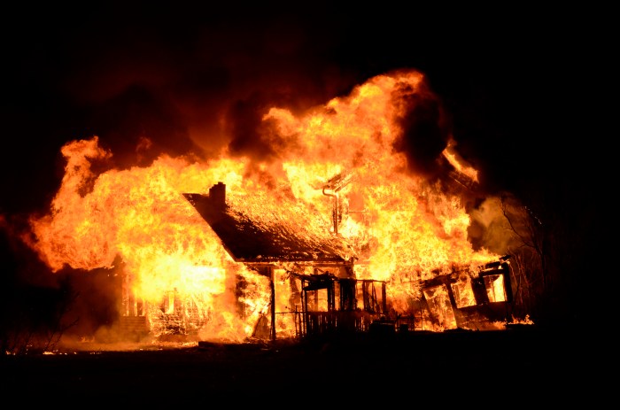
House fire, photo by Ogedn

“The proponents of the cometary explanation cite many fascinating details confirmed by eye witness reports: the descent of fire from the heavens, a great ‘tornado’ of fire rushing across the landscape and tearing buildings from their foundations, descending balls of fire, a rain of red dust, great explosions of wind accompanied by blasts of thunder, buildings exploding into flame where no fire was burning, and a good deal more.”
~thunderbolts.info

We all probably know of Mrs. O’Leary’s cow and the Chicago Fire that burned over three miles of the city to the ground, but perhaps you’d care to take “Fires beginning October 8, 1871” for $500? Four fires began 144 years ago on this day in 1871: the Great Chicago Fire, the Great Michigan Fire, the Peshtigo (Wisconsin) Fire and the Port Huron Fire.

I’m going to let the crew of thunderbolts take it away with an excerpt from their fascinating feature The Comet and the Chicago Fire:

Contrary to popular folklore, the Chicago fire is not the worst in U.S. history. It was not even the worst to occur on October 8 that year. The same evening—in fact, at the same time, about 9:30—a fierce wildfire struck in Peshtigo, Wisconsin, over 200 miles to the north of Chicago, destroying the town and a dozen other villages. Estimates of those killed range upward from 1200 to 2500 in a single night. It was not the Chicago fire but the simultaneous “Peshtigo Fire” that was the deadliest in U.S. history.

And there is more. On the same evening, across Lake Michigan, another fire also wreaked havoc. Though smaller fires had been burning for some time—not unusual under the reported conditions—the most intense outburst appears to have erupted simultaneously with the Chicago and Peshtigo fires. The blaze is said to have then burned for over a month, consuming over 2,000,000 acres and killing at least 200.

Concerning the Michigan outburst, it is reported that numerous fires endangered towns across the state. The city of Holland was destroyed by fire and in Lansing flames threatened the agricultural college. In Thumb, farmers fled an inferno that some newspapers dubbed, “The Fiery Fiend.” Reports say that fires threatened Muskegon, South Haven, Grand Rapids, Wayland, reaching the outskirts of Big Rapids. A steamship passing the Manitou Islands reported they were on fire.

There can be no doubt that weather conditions at the time favored wildfires. But never before, and never since, has the U.S. seen such wildly destructive simultaneous conflagrations. This “coincidence”, combined with many unusual phenomena reported by eyewitnesses, has led some to conclude that an extraordinary force, one not of the earth, was a more likely “arson” than either a misbehaving cow or a regional drought.

In 1883, Ignatius Donnelly, author of Ragnarok: the Rain of Fire and Gravel, suggested that in early historic times our Earth suffered great catastrophes from cometary intruders. To this claim he added: “There is reason to believe that the present generation has passed through the gaseous prolongation of a comet’s tail, and that hundreds of human beings lost their lives”. He was referring to the conflagration of 1871.

Definitely read on for much more about the possibility of a comet’s tail, perhaps Comet Biela, fueling the fires.

Ogedn took this photo of a controlled burn by the local fire department, who practiced on this house before letting it burn. View the photo background big and see this and lots more in their slideshow.

Tons more Michigan history on Michigan in Pictures.

PS: I definitely did more research on this than I should have on this, and while the cometary theory and Comet Biela was observed to be broken apart on its pass in 1846, it may be that Biela’s Comet returned in September of 1872. In any case check the article out and also their Picture of the Day for a lot more than you’ve probably thought about.

#TBT: Beach Day at Port Austin

Beach Day at Port Austin Lake Huron

Beach Day at Port Austin, photo courtesy Don Harrison/UpNorth Memories

I believe this spot is now the Port Austin Harbor, but if you’re looking for a swim, the Port Crescent State Park on Lake Huron looks pretty great!

Check the photo out background big and see TONS more pics mainly from Michigan in Don’s massive UpNorth Memories Photo Tribute to Michigan Historian Dave Tinder slideshow.

More beaches, more Lake Huron and more Throwback Thursdays on Michigan in Pictures!

#TBT: Yesterday & today at the James Scott Memorial Fountain

James Scott Memorial Fountain 1932

James Scott Memorial Fountain, c 1932, photo by Tom Clark

Here’s a fun pair of pics. Tom went back to where this family photo was taken in the early 30s and got a picture of the scene. You can see the one above background big, the one below right here and see more including another shot from the Belle Isle Conservatory in his Wonderful Michigan slideshow.

James Scott Memorial Fountain Bell Isle

More Belle Isle including the story of the James Scott Memorial Fountain on Michigan in Pictures.

#TBT Michigan Asylum for Insane Criminals … and a Postcard Show!

Ionia Michigan Insane Asylum

Michigan Asylum for Insane Criminals, photo by Don (the UpNorth Memories Guy) Harrison

Don wanted me to be sure to let everyone know about this weekend’s annual Traverse City Antique Postcard & Rare Paper Show on August 16 from 10 AM – 4 PM at Northwestern Michigan College’s Hagerty Center. It’s a great chance to view some incredible pics of Michigan’s history … and from all over!

Speaking of history, Asylum Projects page on the Ionia State Hospital says:

The building of the Ionia State Hospital was authorized in 1883 and was opened under the name of the Michigan Asylum for Insane Criminals in 1885. It was found that this name was objectionable as not all of the patients in the hospital were criminals, so the name was changed by legislative action to Ionia State Hospital. The patients committed to this hospital were insane felons, criminal sexual psychopaths, insane convicts from other prisons, patients transferred from other state institutions that had developed dangerous or homicidal tendencies and persons charged with a crime but acquitted on the grounds of insanity. Initially the hospital patients were housed at the site of the Michigan Reformatory.

The hospital was called the North Branch and the farm located on Riverside Drive was called the South Branch. When a large fire broke out at the hospital, all of the rooms were needed to house prisoners, so all of the hospital patients were sent to the South Branch farm. Since that time, the hospital has been located on the grounds of the Riverside Correctional Facility. The hospital was used to treat the mentally ill as well as the criminally insane until 1972, when civilians were removed from the hospital. In 1977, the Legislature transferred the operation to the Department of Corrections when it began operation as a correctional facility. The facility was closed with the reopening of the Michigan Reformatory.

Click through for some pics including a couple of cool panoramas!

View the photo background big and see more from UpNorth Memories on Flickr!

#TBT: Soo Ice Jam of 1953

Soo Ice Jam of 1953

Soo Ice Jam of 1953, shared by John Rodawn

The Ludington Daily News from April 9, 1953 had an article titled Try to Clear Soo Lock Ice with Freighters’ Backwash that said:

SAULT STE. MARIE MICHIGAN – Three powerful lakes craft churned their propellers in a huge “Operations Backwash” today hopeful they could clear the Sault locks of an ice jam which has lied up nearly one-third of the Great Lakes fleet. The Coast Guard icebreaker Mackinaw was joined by the Pittsburgh Steamship Company freighter Arthur Anderson and the Canadian freighter Manladoc (not sure this is the right name) in the operation. Shipping men and lock engineers decided on the maneuver after an aerial survey showed the Whitefish Bay area, above the locks, was entirely free of the ice formation which has passed into the proper.

The three craft were tied up side by side at a dock and then went into action, with the propellers turning at full speed to churn up the water. Officials were hopeful the backwash would push the icy mess about 800 feet upstream, against the current, and get the ice in a position so it would be caught in a cross – current and washed over the Soo Rapids and out of the locks area. Coast Guard Commander T. A. Dahlburg of the Sault area expressed belief the ice would be cleared by this weekend, perhaps as early as Friday. Dahlburg reported 90 lake craft were tied up above the locks awaiting passage, while 64 were tied up below the locks upward bound. He called it the largest concentration of shipping ever assembled in the Sault area.

Under Dahlburg’s plan to keep some traffic operating, only the most powerful of the lake freighters and carriers were permitted to make their way downbound through the icy slush in the American locks. The only upbound traffic yesterday was through the Canadian lock, seven vessels passing through while 17 came down on the U.S. side.

View this postcard shared by John Rodwan bigger on Facebook and see a lot more in the Northern Michigan Postcards group.

More about the Soo Locks and more #TBT aka Throwback Thursdays on Michigan in Pictures.

#TBT – Ice Caves of 2015

Icicles on cave - Grand Island Ice Curtains on Lake Superior - Munising, Michigan

Icicles on cave – Grand Island Ice Curtains, photo by Craig

As the mercury climbs and some crazy people (such as yours truly) start grumbling about the high temps, it’s probably a good time to take a look back at last winter’s spectacular ice caves.

Aubrieta Hope shared the story of her trip with Craig and two other photographers (Neil Weaver & John McCormick) to check out the Grand Island ice curtains. All four are Michigan in Pictures regulars – click to check out In Search of Superior Crystal on the Pure Michigan Blog. It has a bunch of photos and begins:

In the heart of winter, when the drifts are as high as houses and snow-dusted pines line the roads, photographers travel to the Upper Peninsula in search of crystal. Not antique-store crystal, but Superior crystal, the kind that occurs when the north wind turns every drop of open water into something sparkling and new. During the coldest months, the great lake freezes, heaves and breaks, forming mountains of crystal rocks, so tall they seem like permanent landforms. Icebergs and volcanoes rise in the harbors and bays, reflecting all the colors of the sky. Waterfalls slow from a rush to a trickle, building columns that bubble and sing. And, on the sandstone cliffs, springs that flow unseen in the summer months create glittering ice curtains.

During winter’s last stand, at the very beginning of March, I headed north to find Superior crystal. My trip was inspired by winter photographs of the U.P. that I’d viewed online. I’d seen dramatic images of enormous frozen waterfalls, great Superior ice fields, and shining rivers wreathed in morning mist. I wanted to experience and photograph all those scenes, but more than anything, I wanted to see the legendary ice curtains of Grand Island in Munising Bay. These immense, aqua blue ice curtains form when cold temperatures freeze the springs that seep from the island’s rocky cliffs. It can be tricky to get to the ice curtains, though. The island is not accessible every winter because the currents are strong in the bay, preventing adequate ice buildup. During last year’s historically cold winter, the bay froze sufficiently to allow foot traffic. For awhile it looked like Grand Island would not be accessible this year, but February’s arctic blast arrived just in time.

View Craig’s photo bigger and see & purchase more in the Grand Island Ice Curtains – Munising gallery on Craig’s website.

PS: The Grand Island National Recreation Area is located just off the coast of the UP in Munising and is an amazing place, complete with mountain bike trails!

PPS: More ice caves on Michigan in Pictures too!

PPPS: I really am a fan of the PS. If you are too, please PS in the comments!

#TBT: Atop Miners Castle

Atop Miners Castle

Atop Miners Castle, photo by Roger Dinda

On April 13, 2006 one of the most recognizable rock formations in the Pictured Rocks National Lakeshore, Miners Castle collapsed. The Lakeshore explains:

On Thursday morning, April 13, 2006, the northeast turret of Miners Castle collapsed. One turret remains on Miners Castle, the best-known feature of Pictured Rocks National Lakeshore. The collapse was reported via cell phone by fisherman in the area, according to chief ranger Larry Hach. Most of the rock fell north and into Lake Superior, and there were no injuries. The lower overlook platform near Miners Castle appears to be unaffected.

While the rockfall at Miners Castle on April 13 was startling, such events are not rare along the Pictured Rocks escarpment. At least five major falls have occurred over the past dozen years: 1) two different portions of Grand Portal Point, 2) the eastern side of Indian Head just east of Grand Portal Point, 3) Miners Falls just below the (now modified) viewing platform, and 4) beneath the lip of Munising Falls (along the former trail that went behind the cascade).

All the rockfalls involved the same rock unit, the Miners Castle Member of the Munising Formation. Rock units are named for places where they were first technically described. The Miners Castle Member consists of crumbly cross-bedded sandstone that is poorly cemented by secondary quartz, according to U.S. Geological Survey Research Ecologist Walter Loope.

Rockfalls along the cliffs typically occur in the spring and fall due to freezing and thawing action of Mother Nature.

Joel says that this photo was taken Roger Dinda in 1961 or ’62 “…before Pictured Rocks was a National Lakeshore, before Miners Castle lost its second turret, before they put up the boardwalks and railings. In this photo I’m just as tense as I look. I am deathly afraid of heights and this was (still is) about the scariest place I’ve ever been.”

View his photo background big more in his Lake Superior slideshow.

There’s more Throwback Thursdays, more Miners Castle & more from the Pictured Rocks National Lakeshore on Michigan in Pictures!

#TBT: Apple Island in Orchard Lake

Apple Island

Apple Island Aerial, photo via MSU Michigan History Student Publication

I was fascinated with the Farmer’s Almanac weather history tool this morning, so I went looking for notable Michigan happenings on June 18th…

Wikipedia’s Apple Island entry says that this 35-acre island was formed during the region’s last ice age (10,000 to 12,000 years ago) and lies in the middle of Orchard Lake. The West Bloomfield Historical Society has a nice article on Apple Island that says (in part):

Apple Island’s first admirers were Stone-Age Indians, who may have discovered it as early as 2,000 years ago. They were probably drawn to the site for its unique combination of land- and water-based resources, and the fact that their personal security was also enhanced on an island. It is not known exactly which Native Americans frequented Apple Island over the centuries before white settlement, but each group left clues to its way of life, including those which were raising crops at the time of Carpenter’s 1817 survey. In fact, the entire West Bloomfield lakes area has yielded many beautiful hammerstones, chert spearheads and birdstones – finely polished pieces of slate resembling stylized birds – left by their Native American owners long ago.

The treaty of November 17, 1807, negotiated with the Odawa, Ojibwe, Wyandot, and Potawatomi, ceded a tract of land comprising roughly the southeast quarter of the lower peninsula of Michigan and a small section of Ohio to the United States government. In time this land was surveyed, subdivided and offered for sale. Early settlers in what would become West Bloomfield Township noted that Native Americans visited the island often. In their language they reportedly referred to the area as “apple place” – a name which evidently stuck.

Read on for much more including the possibility that Chief Okemos was born on the island, its first purchase on June 18, 1827 by James Galloway and its current status as the Marjorie Ward Strong Woodland Sanctuary. Definitely check out Michigan History at MSU’s West Bloomfield – Apple Island feature for more photos & info and some really cool hand-drawn maps from the early 1900s.

The source of the “apple place” name is from Dr. Samuel M. Leggett’s epic poem The Legend of Me-nah-sa-gor-ning first circulated in 1909.

More Throwback Thursdays on Michigan in Pictures!

#TBT “Shift Change” – Mackinac Bridge construction, 1956

Shift Change at Mackinac Bridge

“Shift Change” – Mackinac Bridge construction, 1956, photo by otisourcat

What’s your commute looking like today? Mightymac.org has a great account of building the Mackinac Bridge, a process that began on May 7, 1954 and was completed November 1, 1957. It begins:

Construction of the Mackinac Bridge began with the construction of the pillars. Caissons were constructed, floated into position and sunk to provide the footings for the two immense towers which would suspend the center span of the bridge. Once the caissons were in place, creeper derricks were added, which raised materials to erect the towers and continued to climb higher.

The Mackinac Bridge roadway truss sections were assembled in sections and floated into position to be raised into place.

Constructing the Mackinac Bridge actually went on into 1958 and took 48 months, 3,500 workers, 895,000 blueprints & structural drawings, 71,300 tons of structural steel, 931,000 tons of concrete, 42,000 miles of cable wire, 4,851,700 steel rivets, 1,016,600 steel bolts and 99,800,000 dollars. There were 350 engineers and another 7,500 men & women worked at quarries, shops, mills and other locations.

When completed, the Mackinac Bridge was the longest suspension bridge in the world and it is currently the longest suspension bridge in North & South America and the third longest suspension bridge in the world.

Read on for lots more including excellent photos of the process and also see these photos of construction of the Mackinac Bridge from the Mackinac Bridge Authority.

otisourcat writes: This is a color slide, but the aged Ektachrome color is so wonky, that the image is much clearer in B&W. View the photo bigger and see more Mackinac shots right here.

There’s lots more Mackinac Bridge photos & info and lots more Throw Back Thursdays on Michigan in Pictures.

#TBT Offseason at the Pontiac Silverdome

Pontiac Silverdome

Pontiac Silverdome, photo by Mathew Davey

With the departure of some key players including Ndamukong Suh, Nick Fairley and Reggie Bush and addition of new faces including Ravens stalwart Haloti Ngata, the Lions have had a fairly eventful offseason. One place that not much is happening is the Lions’ former home, the massive and now domeless Pontiac Silverdome.

Stadiums of Pro Football’s page on the Pontiac Silverdome says that this modern-day ruin was designed by O’Dell/Hewlett & Luckenbach and built at a cost of $55 million:

Home of the Detroit Lions for more than 25 years, the Silverdome was one of the largest stadiums in the NFL. Prior to moving into the Silverdome, the Detroit Lions had played at Tiger Stadium since 1938, that was also the home of the Detroit Tigers (MLB). Tiger Stadium was primarily a baseball stadium, but served as the home to the Lions for more than 30 years. In the late 1960s, the team wanted a new football only stadium. After several bonds were passed allowing the team to build a stadium, the Lions bought land in nearby Pontiac, MI. Because of the area’s cold winter weather, the team decided to build a domed stadium. Construction on the stadium, named the Pontiac Silverdome, began on September 19, 1973 and was completed in 23 months.

Opening day for the Lions at the Silverdome was on October 6, 1975. The Silverdome became the largest stadium in the NFL with a capacity of 80,311. Three tiers of blue seats circled the entire Astroturf playing field. The roof at the Silverdome consisted of Teflon-coated fiberglass panels. In 1985 after a heavy snowstorm the roof was structurally damaged. However over the next several months a new canvas and steel-girder reinforced roof was added to prevent the problem from occurring again. The Silverdome had several amenities that included 93 executive suites and a club restaurant. Other than hosting football games, the Silverdome hosted many other events including tractor pulls, soccer and basketball games, and concerts. The first Super Bowl played in a northern city, Super Bowl XVI between the Cincinnati Bengals and San Francisco 49ers, was played at the Silverdome. In the mid 1990s, the Lions became dissatisfied with the Silverdome. By 1997, bonds were passed allowing construction of a new domed stadium in downtown Detroit. The Lions played their final game at the Silverdome on January 6, 2002. The team moved into Ford Field in August 2002.

The Oakland Press has 89 historical photos of the Silverdome including a couple with Barry Sanders. If you want to go get all depressed instead, head over to Curbed Detroit for the saga of the godawful mess the Silverdome has become.

Matthew took this photo in December of 2014. Click to view it big as the Silverdome!

More Detroit Lions on Michigan in Pictures.