Michigan’s Second Oldest City: Looking back on St. Ignace

st-ignace-lighthouse-explore-july-20-2012

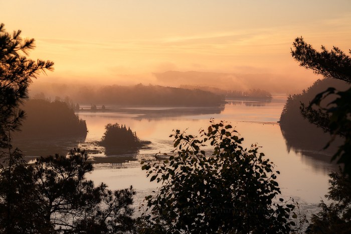
St Ignace Lighthouse, photo by Sheldon Spurrell

You may know that Père Jacques Marquette founded Michigan’s oldest city Sault Sainte-Marie in 1668, but do you know Michigan’s second old city? If you can read titles, you know that’s St. Ignace, founded in 1671 and named in honor of Saint Ignatius of Loyola. Here’s some of the history of St. Ignace from the St. Ignace Visitor’s Bureau:

The natives of the St. Ignace region were migratory. In the spring, the Anishinabeg gathered maple sugar and fished sturgeon and smelt. Summer found them in settlements surrounded by crops of corn, potatoes and squash, and near the abundant supplies of wildlife, fish and berries. They developed efficient housing, watercraft, hunting and farming tools.

The heritage of the Straits evolved and changed over the centuries beginning with the arrival of Roman Catholic missionaries and then French and British explorers and fur traders … The natural waterway joining Lakes Michigan and Huron at the Straits of Mackinac generated extensive water traffic, and prompted the establishment of an outpost during the period of French occupation. The outpost – Fort de Buade – became the seat of King Louis XIV’s authority in the interior of North America. French notables including Rene-Robert Cavalier, Sieur de La Salle and Antoine Lamothe Cadillac spent time at the post. St. Ignace was among the largest settlements in New France from the last decade of the 15th century until the establishment of Detroit in 1701. The British arrived in the St. Ignace region with the defeat of the French during Seven Years War.

St. Ignace played a pivotal role in the fur trade until this industry began to wane. By the mid-1800’s the financial importance of commercial fishing to the economic well-being of the area eclipsed that of the fur trade. Ancillary industries including curing, packing and shipping augmented the fishery. It was during this period that the Mackinaw Boat became a familiar sight on the waters in and around the Straits. As the lumber industry in Michigan evolved, St. Ignace became a center for mill yards and its proximity to the shipping lanes added to its importance as a commercial hub in the northern Great Lakes area.

Read on for more including travel information.

Sheldon took this photo back in July of 2012 at sunrise. View it bigger and see more in his Michigan slideshow.

More from St. Ignace on Michigan in Pictures.

Last Dawn of Summer

last-dawn-of-the-summer

Last Dawn of Summer, photo by John Robert Williams Photography

Since I shared something from the first day of fall, it seems only fitting that I share something from the last day of summer! Here’s a stunning sunrise over West Grand Traverse Bay in Traverse City by my friend John!

Click the pic to view it background bigilicious and get more from John, including professional portraits at jrwpix.com!

More Traverse City and more summer wallpaper on Michigan in Pictures!


Sunrise on McCarty’s Cove & Marquette Harbor Lighthouse

%22mccartys-cove%22-marquette-harbor-lighthouse-marquette-michigan

“McCarty’s Cove” Marquette Harbor Lighthouse, photo by John McCormick

Just got back from Marquette, and I have to say, this is one cool city!!

John took this photo back in August of 2011 at sunrise at McCarty’s Cove, one of Marquette’s best beaches according to Travel Marquette. I really had to dig (seriously, a Mining Journal history quiz was all I had to go on) to learn that McCarty’s Cove is named after Mike McCarty whose business, Lake Superior Ice, operated at that location. I’m not sure how long, but in 1919 they took over the Marquette Ice Company. Know more? Post it in the comments!

UPDATE:  Ann Fisher (who is a contributing photographer to Michigan in Pictures) shares:

“McCarty’s ice business lasted at least into my childhood (late 50’s, early 60’s). I remember going there to buy ice when we were making homemade ice cream in our hand-cranked ice cream maker.”

The Marquette Harbor Lighthouse is now a museum – click for more.

View John’s photo bigger, see more in his Sunsets/Sunrises slideshow, and view and purchase his work at michigannutphotography.com (FYI you can buy this photo right here).

Glory Lake Sunrise and Kettle Lakes

Glory Lake Sunrise

wGlory sunrise 1, photo by Jeff Caverly

The Michigan DNR’s page on Bright and Glory Lakes near Grayling includes maps. They say that both lakes have floating piers & boat launches for fishing – species include largemouth bass, rainbow trout, smallmouth bass, sucker, sunfish, yellow perch:

These lakes are called Kettle Lakes as they are shaped like tea kettles. They are roundish and deep in the center (more than 40 feet). The lake bottom is marl, so wading and swimming are prohibited as people would sink in the marl.

Here’s more about Kettle Lakes from MSU’s Geology department:

Kettles are depressions left behind after partially-buried ice blocks melt. Many are filled with water, and are then called “kettle lakes”. Most lakes in Michigan could be described as kettle lakes, and the term “kettle lake” describes the way the lake basin was formed. Kettle lake basins were formed as the glaciers receded. While this was happening, a block of ice broke off the glacier, and just sat there. As the glacier continued to melt, the debris from the glacier (soil, rocks, stones, gravel, etc.) filled in around the block of ice. When the block of ice finally melted, all the debris surrounding it fell into the hole, creating the kettle type basin, which when filled with water, became a lake as we know it.

Many of our small, deep lakes in Michigan are kettle lakes. Some have since been infilled with vegetation and plant matter, to form bogs. Even some of our larger, deep lakes, like Higgins Lake and Walled Lake, are kettles.

View Jeff’s photo background big, see more including another view of the sunrise in his slideshow, and follow Jeff Caverly Photography on Facebook.

Summer Solstice and a Strawberry Moon

Summer Solstice 2013 by Ken Scott

Summer Solstice … 2013, photo by Ken Scott

Today at 6:34 PM EDT, the summer solstice officially ushers in summer. EarthSky shares that the full Strawberry moon tonight for the solstice is the first full moon to fall on the summer solstice since June of 1967 and the Summer of Love.

Back in 2001, NASA’s Earth Science Picture of the Day (<–my favorite photo blog – subscribe!) shared the tale of Eratosthenes, the Solstice and the Size of the Earth:

Calculating the SolsticeIt was near the summer solstice of 240 BC that Eratosthenes, curator of the famed Library of Alexandria and renowned mathematician and geographer, performed his famous experiment in Egypt to calculate the diameter of the Earth. The bottom of a deep well in the city of Syene, Egypt (near the present day Aswan Dam and very near the Tropic of Cancer) was known to be illuminated by the sun directly at mid-day on the longest day of the year (the solstice). But on the same day, a vertical pole in Alexandria, some 800 km to the north, cast a distinct shadow. By measuring the shadow and applying the geometry of a sphere, Eratosthenes calculated the Earth’s diameter with remarkable accuracy. Sadly, the concept of a spherical Earth was lost from common thought for over a thousand years until Christopher Columbus and others proved the fact by sailing west to go east. The background reference image of Egypt and the Nile River is provided by the NASA MODIS instrument.

Sep 5, 2006 – Donald Etz notes: “From reading Jeffrey Burton Russell’s book, Inventing the Flat Earth (1991), I was persuaded that most educated Europeans of Columbus’ time believed the earth is round. The main debate seems to have been over its dimensions. Columbus ventured on his voyage because he believed the earth was much smaller than it is.” -ed

View Ken’s photo of the sunrise on the 2013 summer solstice bigger, see more in his Boat(s) slideshow, and definitely check out kenscottphotography.com to view and purchase his work.

More science on Michigan in Pictures.


Morning Light at the Manistee Pierhead Light

Manistee Lighthouse

Manistee Morning Light, photo by Heather Higham

Terry Pepper’s Seeing the Light has an extensive entry on the history of the Manistee Pierhead Light with copious information and historical photos. Terry goes deep on Manistee’s history as a lumber port:

Although the first sawmill had been established on the banks of the Manistee in 1841, settlement in the area was not widespread until the Chippewa relinquished their reservation by treaty in 1849, and the federal government offered lands along the Manistee for public sale. It did not take lumber interests long to realize the incredible potential of the Manistee which snaked a hundred miles into the forests, and lumbermen soon began lobbying for federal funding to improve the harbor and to erect a lighthouse at the river mouth. With no appropriation forthcoming, the businessmen of Manistee took the matter into their own hands, erecting a pair of short stub piers at the river mouth in an attempt to stem the deposition of sand and silt.

In 1861, Congress instructed the Army Corps of Engineers to dispatch an Engineer Officer to Manistee to conduct a survey of the river entrance. Water depth in the opening between the piers was found to be from seven to eight feet, and a 250-foot long sand bar with a water depth of less than five feet above it was identified 600 feet off the end of the piers.

…To serve this burgeoning maritime commerce, the piers were extended an additional 150 feet in 1875, and the channel between them dredged to a minimum depth of ten feet. With the main light now standing a considerable distance to the rear of the pierheads, the decision was made to replace the shore light on the north bank with a pierhead beacon on the outer end of the longer south pier. Click to view enlarged image The new south pierhead light consisted of a timber-framed pyramidal beacon typical of the type being erected on pierheads throughout the Great Lakes. With its lower half open, the upper half immediately below the gallery was enclosed to provide a small service room for lamp maintenance. Equipped with windows, the service room also served as a sheltered area in which the keeper could stand watch during inclement weather. Standing 27 feet in height, the beacon was capped with a square gallery with iron handrails and an octagonal cast iron lantern installed at its center.

Read on for a whole lot more.

About the photo, Heather writes:

I still can’t believe I managed to drag myself out of bed this morning. There were 8 minutes of pink light – and a stunning sunrise to the east that I completely ignored – followed by about 90 minutes of interesting (if not sunrise) light.

View it bigger, see more in her Lighthouses slideshow and definitely add Snap Happy Gal Photography to your Facebook follows!

More Michigan Lighthouses and more sweet sunrises on Michigan in Pictures.

In honor of all who served

Veterans Memorial Wyandotte

Thank You for Keeping Us Safe…, photo by Kenneth Raymond

Thanks to all of you veterans and your families in Michigan and elsewhere for your service and sacrifice.

View Kenneth’s photo bigger and see more in his slideshow.


Sunrise at Iargo Springs

Iargo Springs Ausable River

Iargo Sunrise, photo by Tamara Rivette

It’s always cool to discover a new Michigan vista via Michigan in Pictures. Au Sable River Valley Online’s page on the River Road National Scenic Byway says:

Lying off of River Road National Scenic Byway, Iargo Springs provides a panoramic view of the Au Sable River. Used as a drinking water source since pre-settlement times, dams were constructed on the springs by early loggers before the turn of the century. The dams were useful in diverting water to the logging camps nearby. Most of Cooke Pond was dry land then.

Europeans have visited the springs for recreation since the 1920s. A trail to the springs was constructed by the Civilian Conservation Corps in 1934. Early photographs show the dam being repaired and reinforced by the CCC’s. The dams lasted until 1981 when a storm took them out. The site was renovated in 1991. Steps were added and boardwalks along the springs, as well as the dams being rebuilt.

You can click through for a map and more sites along Michigan’s most historic trout stream.

View Tamara’s photo bigger and see more in her 2015 Landscapes slideshow. Also be sure to follow her on Facebook at Tamara Rivette Photography.

Better Know a Michigan State Park: Port Crescent State Park edition

Port Crescent State Park

Port Crescent State Park, Michigan, photo by Zack Schindler

The Michigan DNR says that Port Crescent State Park:

…is located at the tip of Michigan’s “thumb” along three miles of sandy shoreline of Lake Huron’s Saginaw Bay. Some of the modern campsites offer a waterfront view, either of the Bay or the Old Pinnebog River channel. Port Crescent recently added a new camper cabin which sleeps six and has a scenic view of Saginaw Bay. A wooden boardwalk parallels the day-use shoreline offering many scenic vistas of Saginaw Bay. The park also offers excellent fishing, canoeing, hiking, cross-country skiing, birding, and hunting opportunities.

And see the map and book campsites here.

View Zack’s photo background bigtacular and see more in his Fuji X-series slideshow.

More state parks and more incredible Michigan wallpaper on Michigan in Pictures.

Christmas Survivors

Christmas Survivors

Pink Glow, photo by Northern Living Photography

Dee shared this gorgeous shot from near Greenbush of some trees that managed to live to grow another season!

View her photo bigger on Facebook!