The Misunderstood Michigan Mudpuppy

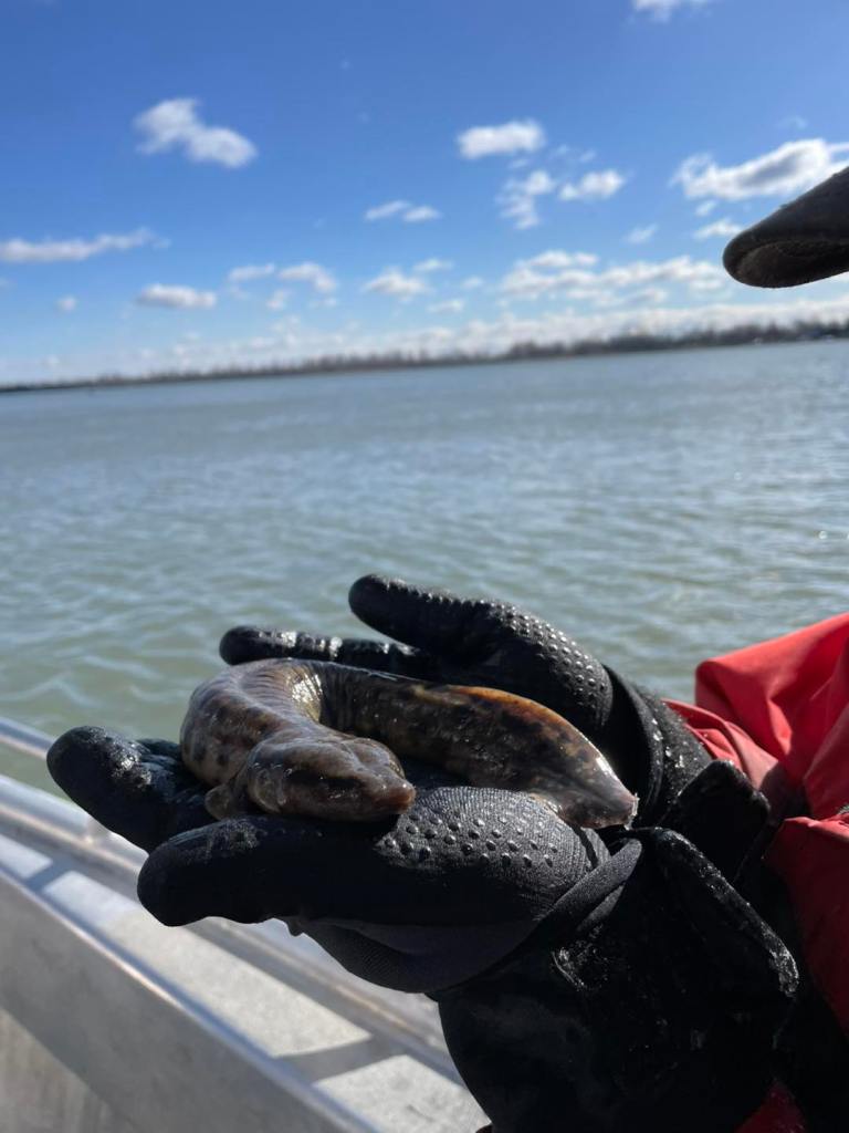
Mudpuppy by Michala Burke/USFWS

The Alpena Fish & Wildlife Conservation Office says that mudpuppies are Michigan’s largest fully aquatic salamander and are often referred to as “bio-indicators” since they are sensitive to pollutants and poor water quality. This mudpuppy was caught during lake sturgeon setline assessments on the Detroit River. Mary of MSU Extension put together a great guide to the misunderstood mudpuppy that includes the facts on some common fictions.

FICTIONFACT
Mudpuppies are a type of fish.Mudpuppies are actually an amphibian and although they have lungs and can gulp air they rely on their feathery red external gills for oxygen.
Mudpuppies that are thrown on the ice by anglers will revive in the spring when the ice melts.Unfortunately if a mudpuppy freezes it will die. When thrown on the ice mudpuppies will eventually suffocate or freeze to death.
Mudpuppies eat so many fish eggs that they decrease sport fish populations.Their diet is mostly crayfish, insect larvae, snails and small fish (including invasive round gobies). There is no evidence that they impact fish populations, and they more likely benefit them by helping control nonnative species.
Mudpuppies are not protected in Michigan and can be collected all year round.According to MDNR, mudpuppies are a protected species in Michigan. People sometimes accidentally catch them while fishing. If you do catch a mudpuppy, you must put them back.
Mudpuppies are blind and are not good hunters.Mudpuppies are not blind, but their eyesight is limited. They rely on a keen sense of smell to find their prey.
Support Michigan in Pictures with Patreon

Big questions about Giant sequoia

Sequoia Redwood Tree by Charles Bonham

Sequoia Redwood Tree by Charles Bonham

My post last week about the planting of Giant sequoia trees in Detroit by Archangel Ancient Tree Archive & Arboretum Detroit got a lot of commentary. While it was generally positive, a common theme of criticism was that we shouldn’t plant things in places where they aren’t native because they don’t belong or can’t survive. On the “can’t survive” front, I give you the 116+ foot tall Lake Bluff Arboretum Giant sequoia tree in Manistee that was planted in 1949.

And while I agree that planting non-native trees is generally a bad idea, the second paragraph of the Bridge Detroit article I linked to explains that it is the environmentally responsible thing to do to allow these forest titans to survive into the future: “The project on four lots will not only replace long-standing blight with majestic trees, but could also improve air quality and help preserve the trees that are native to California’s Sierra Nevada, where they are threatened by ever-hotter wildfires.

And even if clicking a link is two hard, the 2nd of the two paragraphs I chose for the excerpt reads Giant sequoias are resilient against disease and insects, and are usually well-adapted to fire. Thick bark protects their trunks and their canopies tend to be too high for flames to reach. But climate change is making the big trees more vulnerable to wildfires out West, Kemp said. “The fires are getting so hot that its even threatening them,” he said.

You simply gotta read folks. At least if you want to make intelligent critiques.

I had shared a photo of the Giant sequoia in Manistee that Charles took in 2002 2022, but I decided to go back to see what else he had. Lots!! Check them out below and see lots more in his Trees gallery on Flickr.

Support Michigan in Pictures with Patreon

Blue Ice at the Straits of Mackinac

Blue Ice at the Straits of Mackinac by Martin Hogan Photography

Blue Ice at the Straits of Mackinac by Martin Hogan Photography

Although winter “officially” ended yesterday, the snowy pictures I’m seeing from around Michigan this morning make me feel OK sharing these pics Marty got of blue ice on the Straits of Mackinac last weekend. Click to follow Marty on Facebook & for sure check out some of his past photos on Michigan in Pictures!

If you are wondering Why Ice is Blue, Michigan in Pictures says (in part):

As with water, this color is caused by the absorption of both red and yellow light (leaving light at the blue end of the visible light spectrum) … In simplest of terms, think of the ice or snow layer as a filter. If it is only a centimeter thick, all the light makes it through; if it is a meter thick, mostly blue light makes it through. This is similar to the way coffee often appears light when poured, but much darker when it is in a cup.

Support Michigan in Pictures with Patreon

The angle of repose at Silver Lake Dunes

Miniature Landscapes by Neil Weaver Photography

I shared the photo below of what Neil dubbed “The Great Sand Pyramid of Silver Lake Dunes” back on December 17, 2020. Like the ones in the photo above, the lines are so crisp & clear that they look computer generated. Sleeping Bear Dunes is another shifting dune complex, and they explain that the reason that the sand on shifting sand dunes looks the way it does is due to wind & something known as the angle of repose:

Active dunes gradually advance over time. In some places trees and telephone poles have been buried in drifting sand over a period of several years. A common question is “How fast are the dunes moving?” Rates of sand movement vary from one place to another and from one year to the next. At the Dune Climb the average rate of advance has been about 4 feet (1.2 meters) per year over the past few years.

Direction of sand movement also varies from one place to the next. The shapes of dunes reveal the direction of the winds. Dry, loose sand can take on a maximum slope of 34 degrees, known as the angle of repose. As sand piles up on an unvegetated dune, the leeward (downwind) slope approximates the angle of repose, while the windward slope is more gradual. Ripples in the sand show a similar asymmetrical shape.

Dune sand moves primarily by a process called “saltation”, literally “jumping”. Wind forces grains of sand to roll, collide with other grains of sand, and in subsequent collisions some grains bounce into the air, are driven downwind as they fall, and upon landing strike other grains to produce a chain reaction. On a windy day you can see a hazy zone of sand moving just a foot or two above the ground.

Neil took the photo above last year in late December & shared “One of the many things that I love about hiking around the sand dunes is finding miniature landscapes created by the strong winds. The textures and lines compose a true natural work of art!”

Indeed!! See lots more of Neil’s work on Facebook and view & purchase prints, calendars & photography workshops on his website!

The Great Silver Lake Pyramid by Neil Weaver Photography

Support Michigan in Pictures with Patreon

How to see Comet A3

Neowise and meteor by Gary Syrba

There were hopes that Comet C/2023 A3 Tsuchinshan–ATLAS aka Comet A3 would be the comet of the century. While it is not quite that, it does appear that it will be visible for the next couple of weeks just after sunset, even to the naked eye! The good folks at EarthSky offer a helpful checklist to spot Comet A3:

  1. Be sure you’re looking at the correct direction and time. Comet A3 will be visible low in the west after sunset beginning around October 14.
  2. You need a dark, unobstructed sky. Start looking when the sky is dark, but close to sunrise or sunset. Make sure there aren’t hills, trees or buildings blocking your view.
  3. If you can’t see the comet with your eye, try your phone. Most cell phone cameras provide a night or low-light mode. But capturing an image of the comet will require that you hold the camera firmly – or lean against a fixed object like a tree – to avoid shaky or blurred image.
  4. AFTER you’ve located the comet, use binoculars or your eyes to sweep in that area in the sky.

Gary took this shot of Comet Neowise back in July of 2020. See more in his Night Skies gallery on Flickr and view & purchase his work on his website.

Support Michigan in Pictures with Patreon

2024’s Hurricanes are breaking our limits

Sandy’s Frankenwaves by Cory Genovese

8PM EDT: This is nothing short of astronomical. I am at a loss for words to meteorologically describe you the storms small eye and intensity. 897mb pressure with 180 MPH max sustained winds and gusts 200+ MPH. This is now the 4th strongest hurricane ever recorded by pressure on this side of the world. The eye is TINY at nearly 3.8 miles wide. This hurricane is nearing the mathematical limit of what Earth’s atmosphere over this ocean water can produce. -Orlando Meteorologist Noah Bergren

The phrase “nearing the mathematical limit of what Earth’s atmosphere over this ocean water can produce” is one of the most terrifying I have ever read, especially when it directly follows Hurricane Helene that killed over 200 people and wrought devastation even in the mountains. Could this be the hurricane cycle that wakes people up to the reality of a changed climate or will we keep acting like it’s normal for hurricanes to wipe mountain towns off the map? Time will certainly tell.

While it’s too early to forecast the impact of Milton on Michigan, Hurricane Sandy in 2012 produced the second highest wave height ever on Lake Michigan of 21.7 feet – click for all kinds of Lake Michigan Hurricane Sandy weather data from the NWS. Cory took this at Sugar Loaf just outside of Marquette way back in November of 2012 in the aftermath of Hurricane Sandy. See more in his Portfolio gallery on Flickr.

Support Michigan in Pictures with Patreon

Get ready for Comet Tsuchinshan-ATLAS!

via Leelanau.com

Comet C2023 А3 Tsuchinshan-ATLAS by Captures by Ethan

The Planetary Society shares that some astronomers are referring to the newly discovered Comet Tsuchinshan-Atlas as:

… “the comet of the century.” They say it will outshine everything but the Moon in the night sky and that it will stretch its tail over a huge portion of the sky. In that case, people around the world would be able to see the comet without trying at all. On the other hand, some people, like astronomer Dr. Zdeněk Sekanina, have predicted that the comet will break apart around the closest point in its orbit to the Sun, or “perihelion.” Comet Tsuchinshan-Atlas shows no clear signs of fragmenting right now, but that could always change.

…During late September and the first few days of October, you can find Comet Tsuchinshan-Atlas in the constellation Sextans. Look to the east, where the comet will rise about an hour before the Sun if you’re in the Northern Hemisphere. If you’re in a Southern Hemisphere, the comet will rise a bit earlier and be easier to see.

For most of early October, Tsuchinshan-Atlas will be too close to the Sun to be easily visible. Then, starting around Oct. 10 — if all goes well — the comet should be visible after sunset near the horizon in the west. With every passing day, Tsuchinshan-Atlas will start the evening higher in the sky and be easier to spot, unless it gets too dim.

…or breaks up, but if not it could be legendary! Head over to Planetary.org for more!

Ethan shares that he captures this sweet shot of Comet Tsuchinshan-ATLAS rising over Lake Leelanau early morning on Sunday. For more follow him on Facebook. View & purchase his work at capturesbyethan.com.

Support Michigan in Pictures with Patreon

Autumn’s Rainbow: the colors of fall

Fall Color by Bob Gudas

Fall color is really starting to come on in Michigan, and the US Forest service shares that there are three pigments in the palette of autumn color:

Chlorophyll: Gives leaves a basic green color. It is necessary for photosynthesis, the chemical reaction that enables plants to use sunlight to manufacture sugars for food.

Carotenoids: Produces yellow, orange, and brown colors in such things as corn, carrots, and daffodils, as well as rutabagas, buttercups, and bananas.

Anthocyanin: Gives color to such familiar things as cranberries, red apples, concord grapes, blueberries, cherries, strawberries, and plums. They are water soluble and appear in the watery liquid of leaf cells.

Certain colors are characteristic of particular species, and the color of maples leaves differ species by species:

  • Oaks: red, brown, or russet
  • Hickories: golden bronze
  • Aspen and yellow-poplar: golden yellow
  • Dogwood: purplish red
  • Beech: light tan
  • Sourwood and black tupelo: crimson
  • Red maple: brilliant scarlet
  • Sugar maple: orange-red
  • Black maple: glowing yellow
  • Striped maple: almost colorless

Read on for lots more!

Bob took this shot of fall color at Pictured Rocks National Lakeshore in Michigan’s Upper Peninsula back in October of 2011. See more in his Explore gallery and for sure view & purchase his work on his website!

More fall color on Michigan in Pictures!

Support Michigan in Pictures with Patreon

Earth to get an extra moon on Sunday!

He leads me beside the still waters… by Kathy

CNN shares that the Earth will (briefly) be getting a “mini-moon” on Sunday:

The newly discovered asteroid, named 2024 PT5, will temporarily be captured by Earth’s gravity and orbit our world from September 29 to November 25, according to astronomers. Then, the space rock will return to a heliocentric orbit, which is an orbit around the sun.

…The space rock could be anywhere between 16 and 138 feet (5 and 42 meters) in diameter, potentially larger than the asteroid that entered Earth’s atmosphere over Chelyabinsk, Russia in 2013 … But as a mini-moon, Asteroid 2024 PT5 isn’t in any danger of colliding with Earth now or over the next few decades, de la Fuente Marcos said. The space rock will orbit about 2.6 million miles (4.2 million kilometers) away, or about 10 times the distance between Earth and the moon.

Kathie shares that Thumb Lake in Charlevoix County was foggy and lovely when she took this back in October of 2009. See more in her Top 40 gallery on Flickr. Also I get that we’re all worked up about AI, but please look at the 2009 date of the photo ;)

Support Michigan in Pictures with Patreon

The mystery of Great Lakes Sinkholes

Sinkhole Research Cruise by NOAA GLERL

I read an interesting story about scientists exploring a sinkhole in Lake Michigan a couple of weeks ago that detailed how a team of scientists confirmed there are more than 40 sinkholes on the lakebed of Lake Michigan in the Wisconsin Shipwreck Coast National Marine Sanctuary.

What really piqued my interest was learning that that this isn’t the first time sinkholes have been found in the Great Lakes! In 2001, scientists found sinkholes at the bottom of Lake Huron in Michigan’s Thunder Bay National Marine Sanctuary, and I was able to find an award winning Great Lakes Now segment with Steve Ruberg, an observing systems researcher with NOAA’s Great Lakes Environmental Research Laboratory exploring the Lake Huron sinkholes in this very vessel!!

The National Oceanic & Atmospheric Administration’s Great Lakes Environmental Research Laboratory (NOAA GLERL) is dedicated to scientific research on the Great Lakes and coastal ecosystems. They share a lot of amazing photos of their work on Flickr & you can see more from this trip in their Buildings & Vessels gallery on Flickr.

Support Michigan in Pictures with Patreon