The Detroit Flood of June 2021

Detroit Flood by Camera Jesus

Detroit Flood by Camera Jesus

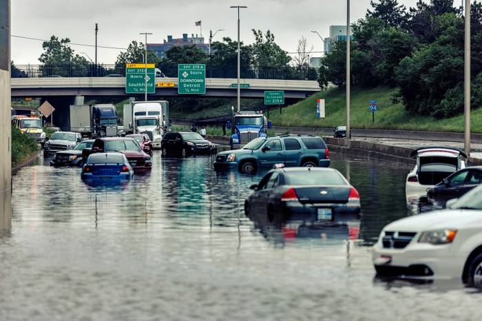
On Friday night as much as 7″ of rain fell in the city of Detroit creating a truly nightmarish situation as the New York Times reports:

Up to seven inches of rain fell early on Saturday in parts of Detroit and Wayne County, Mich., stranding hundreds of vehicles on flooded freeways and prompting the rescue of about 50 drivers, officials said.

“This isn’t normal here,” said Lt. Michael Shaw, a spokesman for the Michigan State Police. “Every freeway in the county had some level of flooding.”

By 3 p.m. Saturday, the authorities counted about 350 vehicles that had been damaged in the flooding.

“Some suffered some type of wire damage, some had water up to the top of their tires, some had it up to windows, and some were completely submerged,” Lieutenant Shaw said. “A lot of people thought they could make it through the water, but there was just no way.”

You can see some shots reader-submitted shots from across the city at Click on Detroit.

The photo was taken Saturday on I-94 aka the Edsel Ford Freeway by Joe Gall aka Camera Jesus. Click the pic for several more shots, follow him @camera_jesus on Instagram & for sure check out his website to view and purchase his work!

More Michigan flooding including the Detroit Flood of 2014 on Michigan in Pictures.

Support Michigan in Pictures with Patreon

Crack in the sky

Lightning Storm by Kevin Povenz

Lightning Storm by Kevin Povenz

Here’s a stunning photo from 7 Junes ago by Kevin. Check out more in his Storms gallery on Flickr.

Also, have a great weekend folks – I’m taking tomorrow off!

Support Michigan in Pictures with Patreon

La Chappelle: The incredible Chapel Rock

Chapel Rock by John Gagnon

Chapel Rock by John Gagnon

Atlas Obscura says that although there’s a whole lot to see in the Pictured Rocks National Lakeshore, hikers should keep their eyes peeled for one feature in particular: Chapel Rock, once known as La Chappelle:

Composed of Cambrian age sandstone dating back approximately 500 million years, Chapel Rock is the result of the erosion caused by a proglacial lake somewhat confusingly referred to as “Nipissing Great Lakes.” This giant body of water consisted of separate basins joined by straits, and once occupied present-day Lake Superior, Lake Huron, Lake Michigan, and Georgian Bay. Around 3,800 years ago, the high waters of Nipissing Great Lakes carved through the soft sandstone, resulting in today’s dramatic formation, which juts out into Lake Superior.

Although Chapel Rock’s stone is mostly beige, its base is a warm orange, thanks to mineral concentrations. The sandstone cliffs that comprise Pictured Rocks are full of iron, copper, manganese, and limonite, which impart red, orange, blue, green, brown, black, and white hues. Not long ago, a natural rock bridge spanned the area between Chapel Rock and the mainland. It collapsed in the 1940s, leaving the formation unconnected with the rest of the shore. Thankfully, the rest of the structure has remained intact and is protected from climbers by order of the Lakeshore Superintendent.

The rock isn’t the only thing that has proven to be remarkably durable. Charles Penny, a member of the Douglass Houghton expedition responsible for exploring Lake Superior’s southern shore, admiringly described a single pine tree that grew like a “spire” out of the sparse dirt covering the top of the outcropping. Till this day, the same resilient pine stands sentinel over Chapel Rock, connected to the mainland by its extensive root system.

More at Atlas Obscura & check out more Chapel Rock photos on Michigan in Pictures that include pictures of the pine tree’s astounding root system.

See more in John’s Pictured Rocks gallery on Flickr.


Support Michigan in Pictures with Patreon

Sail into the sunset … and weekend

Sunset Sailing by TP Mann

Sunset Sailing by TP Mann

TP shares: 

This shot was taken at one of my favorite places for photos, the lighthouse in Charlevoix Michigan along Lake Michigan. This is a case of perfect time and place.

Indeed!! Hope you get some of those “perfect time & place” moments this weekend & this summer.

Check out more stunning shots in TP’s Explored gallery on Flickr.

Support Michigan in Pictures with Patreon

TBT: Last Week’s Eclipse

Eclipse June 10 2021 by Rod Burdick

Eclipse June 10, 2021 by Rod Burdick

Sure it’s a little early for a “Throwback Thursday” pic, but I had to share this shot from last week’s eclipse over the foggy St. Clair River.

Head over to Rod’s Flickr for many more shots of the St. Clair River & Great Lakes marine subjects!

Support Michigan in Pictures with Patreon

Waterfall Wednesday: Upper Hungarian Falls

Upper Hungarian Falls by Eric Hackney

Upper Hungarian Falls by Eric Hackney

It’s Wednesday again so let’s make friends with one of Michigan’s 200+ named waterfalls. GoWaterfalling’s page on Hungarian Falls says:

Dover Creek tumbles overs a series of falls on its way down to Torch Lake. Two of the falls are around 20 feet high, and the last is a 50 foot drop, which is spectacular when the water is flowing. Unfortunately these falls are often nearly dry in the summer.

There are three falls 15 feet or higher on a half mile stretch of Dover Creek, plus a couple of smaller drops. In the spring time, or after some good rains, these waterfalls are very impressive. Unfortunately the creek has a very small watershed, and the falls are often reduced to trickles.

The three main drops are usually referred to as the upper, middle and lower falls. The upper falls is around 20 feet high. The water spills over an irregularly shaped cliff into a small gorge.

Get directions & info about this Keweenaw series of waterfalls at GoWaterfalling.

See more in Eric’s Personal Favorites gallery on Flickr and for sure check out his website to view & buy his prints!

Lots more Michigan waterfalls on Michigan in Pictures.

Support Michigan in Pictures with Patreon

(Tiny) Home for Sale

Home for Sale! by Fire Fighter's Wife

Home for Sale! by Fire Fighter’s Wife

Like much of the rest of the country, Michigan has been seeing skyrocketing home prices.

Beth may have found a solution, but she notes that the neighbors always leave their sprinklers on, which is a little bit annoying but also a source of constant irrigation. 😂 See more in her landscape gallery on Flickr!

Support Michigan in Pictures with Patreon

Scientists now know what causes the northern lights!

Thanks by Julie

Thanks by Julie

NPR reports that scientists have finally confirmed the source of the Northern Lights:

An article published in the journal Nature Communications this week suggests that the natural light show starts when disturbances on the sun pull on Earth’s magnetic field. That creates cosmic undulations known as Alfvén waves that launch electrons at high speeds into Earth’s atmosphere where they create the aurora.

“It was sort of theorized that that’s where the energy exchange is occurring,” said Gregory Howes, associate professor of physics and astronomy at the University of Iowa. “But no one had ever come up with a definitive demonstration that the Alfvén waves actually accelerate these electrons under the appropriate conditions that you have in space above the aurora.”

The sun is volatile, and violent events there such as geomagnetic storms can echo out into the universe. In some cases, the sun’s disturbances are so strong that they yank on the Earth’s magnetic field like a rubber band, pulling it away from our planet.

But, like a taut rubber band when it’s released, the magnetic field snaps back, and the force of that recoil creates powerful ripples known as Alfvén waves about 80,000 miles from the ground. As those waves get closer to Earth, they move even faster thanks to the planet’s magnetic pull.

…”Think about surfing,” said Jim Schroeder, an assistant physics professor at Wheaton College and the article’s lead author. “In order to surf, you need to paddle up to the right speed for an ocean wave to pick you up and accelerate you, and we found that electrons were surfing. If they were moving with the right speed relative to the wave, they would get picked up and accelerated.”

When the electrons reach Earth’s thin upper atmosphere, they collide with nitrogen and oxygen molecules, sending them into an excited state. The excited electrons eventually calm down and release light, which is what we see as the aurora.

More at NPR.

Julie took this celebratory photo back in March. See more in her massive Michigan gallery on Flickr & keep your eyes on the skies!!

More Northern Lights on Michigan in Pictures.

Support Michigan in Pictures with Patreon

Get all the stars at Wilderness State Park

The Milky Way over Lake Michigan at Wilderness State Park by Diana Robinson

The Milky Way over Lake Michigan at Wilderness State Park by Diana Robinson

The Michigan DNR explains that Wilderness State Park is one of Michigan’s Dark Sky Preserves:

Michigan is lucky to play host to both dark sky preserves and parks that offer stellar celestial landscapes. These locations are specially designated because they have qualities that complement nighttime viewing, such as the ability to limit the amount of artificial light. There are also plenty of excellent night-sky viewing opportunities across more than 15,000 square miles in Michigan’s Upper Peninsula.

Diana took this photo earlier in May & you can see more in her Night Photography gallery on Flickr.

More great night photography on Michigan in Pictures!

Support Michigan in Pictures with Patreon

The Age of Wooden Boats at Presque Isle Harbor

Presque Isle Harbor by John Hart

Presque Isle Harbor by John Hart

There’s some names that you see again & again in Michigan. One of these is “Presque Isle”. It means “almost island” in French so you can see why Michigan’s peninsula right coastline brought that to the minds of early French traders.

The US 23 Heritage Route shares that Presque Isle Harbor offers the only natural harbor on Lake Huron with a new marina offering water, restrooms, showers, diesel, electricity, pump-out, gasoline, launch, fishing pier, dog run, grills, and the Portage Restaurant. The Old Presque Isle Lighthouse is a short walk up the path.

Check out the US-23 Heritage Route for more great summer touring options along this northeast Michigan highway!

John shared this cool photo of Presque Isle Harbor during the age of wooden boats. Check out his mix of old & new pics on his Flickr.

Support Michigan in Pictures with Patreon