Mendota Channel Light aka Bete Grise Lighthouse

Bete Grise Lighthouse by Steve Nowakowski

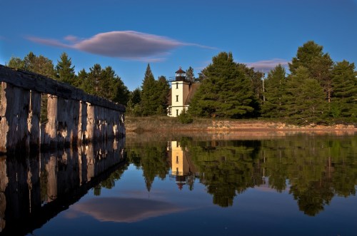
Bete Grise Lighthouse, photo by Steve Nowakowski

Terry Pepper’s Seeing the Light page for the Medota Channel Light says that in response to increasing industrialization around Lac LaBelle, a cut was created from the Lake Superior into Lac LaBelle to allow access to the big ships that plied the Great Lakes.

As a result, the construction of the Mendota Light was first considered by the US Congress in 1867, when an appropriation of $14,000 for the construction of a light station was approved on March 2, with the terms of the contract called for construction of the structure to begin in 1869, with final completion no later than November 1870.

Later that year, it was realized that declining industrial development in the area would no longer support the planned deepening of the cut into Lac Labelle, and it was deemed that the light would serve no purpose. Decommission was ordered, and instructions to dismantle the structure were issued to the crew of the steamer “Haze,” with all equipment to be returned to USLHS headquarters in St. Joseph for eventual reuse. (The lens and mechanics were later reused in the Marquette Breakwater light.)

Thus, the Mendota light station was decommissioned before it saw real service, and the structure sat idle and blinded for the following twenty two years.

In the following years, Great Lakes shipping increased dramatically, and many ships rounding the Keweenaw began using Bete Grise Bay as a shelter during rough seas. In 1892 it was determined that a reactivation of the Mendota light, along with relocation closer to the bay would make bay entry a far safer proposition for such ships seeking shelter. Authorization for reactivation was issued on February 15, 1893, and $7,500 was appropriated to cover the expenses.

Read on for more about this light.

Check Steve’s photo out background bigtacular and see more in his Bete Grise Lighthouse slideshow.

There’s lots more lighthouses on Michigan in Pictures and you might also want to check out the vantage from Bare Bluff on Bete Gris Bay!

Great Lakes Waves offer beauty, power & danger

DSC01071P

Untitled, photo by Scott Glenn

“These are not lakes, these are the world’s eighth seas, and her bottom is littered with the wreckage of over six thousand ships.”
~The Three Sisters, Song of the Lakes

This gorgeous shot of the St. Joseph Pier Lighthouses demonstrates the incredible power of Great Lakes waves. I live in Traverse City, and this summer it feels like Lake Michigan has claimed the lives of more people than normal. Whether or not that’s true (it’s not), I thought this photo offered the perfect opportunity to share some tips and tools for staying safe on Lake Michigan, Lake Huron, Lake Superior and Lake Erie!

  • Thinking of any of the Great Lakes as anything like any lake you’re familiar with is a mistake. They are freshwater seas that can pack  incredible power. They are stronger than you and can end your life in an instant if you don’t respect them.
  • The Great Lakes Surf Rescue Project is a nonprofit dedicated to drowning prevention that keeps track of drowning statistics: 74 in 2010, 87 in 2011, 101 in 2012 and 39 so far in 2013. (you can also keep up with them on Facebook)
  • Life jackets can save your life.  U.S. Coast Guard statistics show that 90% of the people who drown in a boating or water accidents would survive with a life jacket.
  • Cold kills! Hypothermia is a danger all year round on the Great Lakes. Click that link for tips on how to stay alive if you do end up in the water.
  • Rip Currents (sometimes called “undertow” or “rip tide”) are a big danger on Michigan beaches accounting for the majority of drownings. Michigan is 4th in rip current related fatalities behind Florida, California, and North Carolina – we have “ocean force” rip currents. Learn how to beat them in this video.
  • The National Oceanic and Atmospheric Administration (NOAA) offers comprehensive Great Lakes marine forecasts.
  • The MyBeachCast smarthphone app can predict waves and warn you of hazardous conditions.
  • Do you have more tips? Share them in the comments!

Check it out bigger and see more in Scott’s Lighthouses slideshow and also check out a winter view of the pier that Scott shot.

Catch a Michigan wave on Michigan in Pictures!

Detour Reef Lighthouse

DeTour Reef Lighthouse, MI

DeTour Reef Lighthouse, MI, photo by hatchski

Today’s post is from the “What Are the Odds?” category. Some weeks I will sit down on Sunday evening and write a few posts. I wrote this one last Sunday and then on Tuesday, the State Historic Preservation Office announced 2013 recipients of Michigan Lighthouse Assistance Program. Three lighthouses will receive dollars for preservation efforts: the Manistee North Pier Light, the St. Clair  South Channel Range Lights (already profiled on Michigan in Pictures) and the DeTour Reef Lighthouse!

Terry Pepper’s Seeing the Light tells of the history of the DeTour Reef Lighthouse. He begins:

As freighters plying the St. Marys River grew in length and depth, a reef lying 24 feet below the surface off the entrance to the river between Detour Point and Drummond Island became a menace to safe passage between the lake and river. Without funding to erect a lighthouse, an acetylene buoy was placed to mark the reef on September 29, 1897 as a temporary measure.

As part of a major project to improve aids to navigation in the Straits of Mackinac at the end of the 1920’s, the Lighthouse Bureau had proven its ability in the efficient construction of offshore crib-based lights at Martin Reef in 1927, and Poe Reef 1929. With success already in its back pocket, after receiving an appropriation for the construction of a first-class light station on Detour Reef, the Bureau was immediately able to focus its attention on construction of the new station.

The first order of business was the establishment of a land-based camp as close as possible to the reef. Here, the crib which would form the submarine foundation for the structure could be built, and housing could be obtained for the construction crew. By the twin virtues of having deep water close to its shore and its proximity to the construction site, Detour Village was selected as the best location for the base of operations.

You can read on at Seeing the Light for details and photos of the fascinating construction process of this “crib lighthouse” that culminated with the official lighting of the new tower on the night of November 10, 1931. In 1974 the light was automated and in 1997 the lighthouse was declared excess property by the U.S. Coast Guard, but community members were able to come together to for the DeTour Reef Light Preservation Society (Facebook). This successful partnership renovated the lighthouse and now offers YOU the chance to be a volunteer keeper and stay at the lighthouse!

View Mark’s timely photo background big and see more in his massive Mark’s lights slideshow.

Many more Michigan lighthouses on Michigan in Pictures.

Poe Reef Lighthouse

Poe Reef Light

Poe Reef Light, photo by joeldinda

Terry Pepper has (as usual) a very detailed entry for Poe Reef Lighthouse on his Seeing the Light website. This crib style lighthouse is located off Bois Blanc Island in Lake Huron. The reef is very close to the surface and posed a significant threat to navigation until the decision was made in the 1890s to anchor a lightship there. This served until Lighthouse Service decided to build a permanent station on Poe Reef in 1927:

The station building at Poe Reef was to be an exact duplicate of that which the crew had previously completed at Martins Reef. The main twenty-five foot square structure consisted of a steel skeletal framework to which an exterior sheathing of riveted steel plates was applied. Thirty-eight feet tall, it contained three levels, or “decks”, as the crews assigned to the station knew them. The two upper decks were set up as living quarters, while the main lower deck served as housing for the machinery required for powering the lights, heating system and foghorn.

Centered atop the main structure stood sixteen-foot square, ten-foot high watch room of similar construction, with a single observation window on each side. Finally, a decagonal cast iron lantern room was installed on the roof of the watch room, and outfitted with a Third Order Fresnel lens. The combination of pier and tower provided the Fresnel with a seventy-one foot focal plane, and a visibility range of almost twenty nautical miles in clear conditions. Work was completed at the station and the light exhibited for the first time on the evening of August 15, 1929.

At some point in time, in order to eliminate the possibility of the Poe Reef Light being mistaken for the identical all white structure at Martin Reef, the main deck and watch room of the Poe structure were given a contrasting coat of black paint.

Terry has some cool shots of this light as well including this wide shot with cormorants.

Check Joel’s photo out background bigtacular and see more shots from Poe Reef and elsewhere in his Lighthouses slideshow.

More Michigan lighthouses on Michigan in Pictures.

Grand Marais, Michigan

Grand Marais Harbor Outer Light Station

Grand Marais Harbor Outer Light Station, photo by Gary of the North

The Michigan Historical Marker at Grand Marais reads:

Grand Marais, which is among Michigan’s oldest place names, received its name from French explorers, missionaries and traders who passed here in the 1600s. “Marais” in this case was a term used by the voyaguers to designate a harbor of refuge. In the 1800s Lewis Cass, Henry Schoolcraft and Douglass Houghton also found the sheltering harbor a welcome stopping place. Grand Marais’s permanent settlement dates from the 1860s with the establishment of fishing and lumbering. At the turn of the century Grand Marais was a boom town served by a railroad from the south. Its mills turned out millions of board feet annually. Lumbering declined around 1910, and Grand Marais became almost a ghost town, but the fishing industry continued. Many shipping disasters have occurred at or near the harbor of refuge, which has been served by the Coast Guard since 1899. In 1942 the first radar station in Michigan was built in Grand Marais. Fishing, lumbering and tourism now give Grand Marais its livelihood.

Check this out big as Lake Superior and see more in Gary’s slideshow.

More Grand Marais on Michigan in Pictures!

Holland Harbor’s Big Red Lighthouse and the Red Right Return

Big Red

Big Red, photo by Rick Lanting

Sometimes I see photos of certain places so much that I figure I’ve said all there is to say about them. Such was the case with one of one of Michigan’s most iconic lighthouses. I realized that although I’d seen hundreds of photos, I had no idea how “Big Red” in Holland got its name. Terry Pepper’s Seeing the Light tells the story of the Holland Harbor Light from the construction of a timber frame beacon on the south pier in 1870 up until the 1930s when:

The Holland Lights were electrified in 1932. Equipped with a 5,000 candlepower incandescent electric bulb, the Fourth Order lens was now visible for a distance of 15 miles. The old steam-operated ten-inch fog whistle was removed from the fog signal building the following year, and replaced with an air operated whistle powered by an electric motor-driven compressor. In 1936, a square tower was erected at the west end of the fog signal building roof peak, and capped with an octagonal cast iron lantern, the lens from the pierhead beacon moved into the new lantern. The steel pierhead beacon was then removed from the pier and shipped to Calumet, where it was placed at the south end of the breakwater.

A Coast Guard crew arrived in Holland in 1956, and gave the combined fog signal building and lighthouse a fresh coat of bright red paint in order to conform to its “Red Right Return” standard, which called for all aids to navigation located on the right side of a harbor entrance to be red in coloration. Local residents thus began referring to the fifty year old structure as “Big Red,” a name which has stuck through the years. The Fourth Order lens was subsequently removed from the fog signal lantern in the late 1960’s, and replaced with a 250 mm Tidelands Signal acrylic optic.

Much more including photos at Seeing the Light.

Check this out Big Red big and see more in Rick’s Lighthouses or Hipstamatic slideshows.

Many more Michigan lighthouses on Michigan in Pictures!

Ice Kingdom

DSC08043RP

DSC08043RP, photo by Scott Glenn

Incredible what wind, water and way too cold can do! More about the St. Joseph lighthouse on Michigan in Pictures.

Check this out on black and see more icy goodness in Scott’s lighthouse slideshow.

Ludington Lighthouse, with chocolate and whipped cream

lighthouse with chocolate and whipped cream

Lighthouse with chocolate and whipped cream, photo by Craig Sterken Photography

Craig shared this photo of the North Breakwater Pier and Lighthouse in Ludington on the Absolute Michigan Facebook the other day.

See it bigger on Facebook and see more on the Craig Sterken Photography Facebook page or at craigsterken.com!

More shots of  Ludington (and this lighthouse) on Michigan in Pictures.

The Ruins of the Cheboygan Point Lighthouse

Cheyboygan Lighthouse

The Cheboygan Point Lighthouse Ruin, photo by joeldinda

Terry Pepper’s Seeing the Light has information about the ruins of the Cheboygan Main Light Station, explaining:

Located directly across the three mile width of the Straits from the southernmost point of Bois Blanc Island, the eastern prominence of Duncan Bay marked a natural turning point for vessels entering the Straits, and the growing bounty of Lake Michigan beyond.

On December 21, 1850, Congress appropriated the sum of $4,000 for the purchase of a 41.13 acre reservation on what would become known as “Lighthouse Point” at the western end of Duncan Bay for the construction of the first Cheboygan light station … The tower was evidently poorly located, as high water was found to be undermining the stone foundation soon after construction. Fearing collapse was imminent, in 1859 the newly-formed Lighthouse Board decided to build a new station and demolish the original tower, only eight years after its construction.

The replacement station, was similar in design to that built at Port Washington the following year, consisting of a combined keeper’s dwelling and tower, with the tower located at the north apex of the hipped roof. The tower stood thirty-one feet above the foundation, and was capped with an octagonal iron lantern into which the Fresnel from the old tower was carefully relocated. The lights’ thirty-seven foot focal plane provided a twelve mile range of visibility, thereby providing coverage throughout the Straits.

Read on the story of how the second lighthouse ultimately met its end and some great old photos of the lighthouse. It’s located in Cheboygan State Park.

Joel writes that they walked the park’s Yellow Trail to the long (2 miles in the park) beach and walked along Lake Huron’s Mackinac Strait. View his photo background bigtacular, see it on his map and check out more great shots in his Cheboygan slideshow.

Many more Michigan lighthouses on Michigan in Pictures.

The Ghost Keeper of Old Presque Isle Lighthouse

Old Presque Isle Lighthouse, photo courtesy Archives of Michigan

The Lightkeeper’s Ghost tells the tale of George and Loraine Parris who became the beloved caretakers of the Old Presque Isle Lighthouse, running the small museum and giving tours. George was something of a trickster and delighted in playing harmless tricks on visitors. He passed away in 1992, but the story doesn’t end there.

As Loraine was driving to the property on Grand Lake Road, which had a clear view of the lighthouse, she saw that it was illuminated.

She knew that the Coast Guard had rendered this impossible, but there it was before her. By the time that she arrived at the keeper’s house, though, everything was dark. The next day she climbed the steps of the lighthouse to make sure that everything was in order, and she saw that there was no way that someone could have turned the light on. Yet, this same pattern repeated itself again and again. Loraine never said anything about it because she thought that people might think her crazy.

Soon other folks began to see the light, however – a yellowish glow was reported from the lighthouse by several people. Some thought that the light had been put back into operation, but others drove out for a closer look, only to find that it was dark once again.

It was even spotted by members of the Air National Guard, who flew a few missions over the area, and by the Coast Guard, who investigated to make sure that no one could fire the light back up. It had been permanently disabled years before, so there was no way that the light could be shining. Yet it was. Many people believe that the spirit of playful old George is occasionally paying a visit to the lighthouse that he loved so much, just to let folks know that he’s doing just fine and to keep alive the stories of the lighthouse that he loved so much.

Read more about the history of the lighthouse from TexasEscapes.com and learn more about the light and visiting from the Presque Isle Township Museum Society.

This photo from Seeking Michigan and the Archives of Michigan was taken in 1963 at Old Presque Isle Light. See it bigger and check out more of their photos of the old and new lighthouses on Presque Isle.

More ghosts and ghost stories on Michigan in Pictures.