Waugoshance Morning

Waugoshance Lighthouse - Morning

Waugoshance Lighthouse – Morning, photo by lomeranger

You can today’s photo under “dedication” as photographer Jason Lome hiked 18 miles hauling his camping gear in temperatures ranging from 0 to -20F to get this shot! You can purchase right here.

The Waugoshance Shoals entry at Terry Pepper’s fantastic Seeing the Light website tells the origin of this ruined light and of the significance of this site in Great Lakes Lighthouse history:

After a number of groundings in the early 1820’s, mariners began petitioning the Federal Government to construct an aid to navigation on Waugoshance Shoal. While the construction of underwater cribs had been attempted with success on the East Coast, the relatively short shipping seasons and thick winter ice of northern Lake Michigan appeared to make such an undertaking a daunting challenge.

As an interim measure, the wooden vessel LOIS MCLANE, which had been converted into a lightship, was placed on Waugoshance Shoal in 1832, thus taking her place in history as the first lighthouse to serve on all the Great Lakes.

In 1850, the decision was made to construct a more permanent light on the shoal, and work began with the construction of a timber crib on St. Helena Island. The crib was then towed to Waugoshance and sunk in place through the addition of large rocks.

…Exposed as it was to the full fury of Lake Michigan and to the great breaking fields of ice every spring, the crib began to deteriorate. Reacting to this deterioration in 1865, the Lighthouse Board appropriated the funds required to make the repairs necessary to ensure the station’s continued structural integrity, and quickly completed the work.

While the repairs of 1865 were considerable in their scope, they were no match for the relentless fury of the lake, and by the late 1880’s the crib and the soft brick of the tower had once again deteriorated to the point where major repairs were needed.

There’s much more to found at Seeing the Light including the construction of this edition of the Waugashance Lighthouse and how it came to be a ruin.

Check Jason’s photo out background bigtacular and see more in his Lighthouse slideshow.

There’s lots more about the colorful history of Waugoshance Shoals Lighthouse on Michigan in Pictures, and dozens and dozens of Michigan lighthouses.

A Lighthouse a day keeps the winter away

Frankfort Lighthouse by 22 north

Dawn at Frankfort North Breakwater Light, photo by 22 North Photography

22 North Photography has declared February as Lighthouse Month, sharing 28 Michigan lighthouses in 28 days. Day 1 is the Frankfort North Breakwater Light which marks the entrance to Betsie Lake and the Betsie River in Frankfort.

View the photo bigger on Facebook, keep up on their Facebook page and also see the 22 North Photography website.

Many more lighthouses on Michigan in Pictures.

Lighthouse Punk

DSC07439P

Untitled, photo by Scott Glenn

Kids these days and their crazy hair.

Check Scott’s photo out bigger and see lots more in his Lighthouses slideshow. Also check out a previous photo by Scott on Michigan in Pictures.

Michigan in the Deep Freeze

Icy Evening

Icy Evening, photo by GLASman1

Some of the coldest air in decades has moved into Michigan, producing morning temps in the low teens to single digits and packing windchills over -20! The lowest temp? Ironwood in the western UP at -26! The weather has closed schools in much of the state and has every news outlet and the Michigan State Police warning you about the extreme conditions.

The Freep is reporting snowfall totals of 13 inches of snow in Holly and Waterford, more than 16 inches on the ground in Flint and 17 inches of snow in Clarkston as of just after midnight last night! They also have a collection of photos sent in by metro residents.

Weather Underground’s winter storms page has Winter Storm Ion page that will be a good resource for looking back.

mLive has a nice collection of storm information. Meteorologist Mark Torregrossa says that lower Michigan will take the brunt of the snowfall, anywhere from 5-11 inches! They also have some tips for dealing with the extreme cold.

If you live in west Michigan, you may remember the blizzard of January 6, 1999 which dumped 30 inches of snow!

Mark’s photo was taken at Point Betsie lighthouse in January of 2012 and is also the latest cover on the Michigan in Pictures Facebook. You can view it bigger and see more in his Pte Betsie Lighthouse slideshow.

lighthouse snowman

lighthouse snowman

lighthouse snowman, photo by kiwirat

Frosty’s got nothing on the St. Joseph Lighthouse.

View Dave’s photo bigger or in his St. Joseph, MI slideshow.

Seul Choix Pointe Lighthouse is your only choice

Seul Choix Lighthouse, MI

Seul Choix Lighthouse, MI, photo by Wrong Main

We’ve covered the Haunting of Seul Choix Lighthouse on Michigan in Pictures. Dave Wobster has an article on Seul Choix Light at Boatnerd.com. He writes that Seul Choix (“only choice” as the only safe harbor in the area) was popular with Native Americans as early as the 1600s due to the abundant  whitefish and lake trout that were waiting to be caught in Lake Michigan. A fishing village was established in the  mid 1800s and a trading post around 1850.

The early navigation aids along the northern Lake Michigan coast were the lighthouses at St. Helena Island (1872) and Peninsula Point (1866). This left a 100-mile gap of dark shoreline with Seul Choix Bay located near the middle. Efforts were soon started to have a lighthouse constructed on Seul Choix Point. The efforts were successful in 1886 when Congress appropriated $15,000 to build a light tower and fog signal on the point. Another $8,000 was added before the project was completed. Various complications and the rebuilding of the original tower delayed completion of the station.The light was first shown in August, 1892, but the complex was not completed until 1895 with the finishing of the fog signal building. The complex consisted of the present conical 78-foot tower and attached 2-story keeper’s dwelling, a steam fog signal building, stable, boathouse, two oil storage buildings, a brick privy, and boat dock and tramway to the fog signal building.

The keeper’s dwelling was expanded in 1925 with a lean-to addition to the west side. The interior living space was divided with a wall to provide equal space for an additional family. The wall has since been removed, but the building still contains two kitchen areas. Particular attention should be paid to the unique rounded gables on the east end of the dwelling. While they are reminiscent of a sailing schooner stern, history does not provide a reason for this detail.

The 78-foot high white conical tower is the typical elaborate “Poe-Style” named after General Orlando M. Poe who provided the original design. The Poe-style light towers are easily recognized by the ornate brackets which support the gallery around the lantern room and the four windows below the gallery which have semi-circular stone arch head pieces.

Read on for more including some photos of Seul Choix details at Boatnerd.com. The Seul Choix Pointe Lighthouse is maintained by the Gulliver Historical Society and you can get a lot more info (and a snippet of a cool song that plays when you load) at their site.

Bill took this shot in 1997 with Plustek OpticFilm 7600. He writes that Seul Choix is located on the north shore of Lake Michigan a little east of Manistique. View his photo background big and see more in his great Lighthouses slideshow.

Many (many) more Michigan lighthouses at Michigan in Pictures!

Murder Mystery at Grand Island North Light

Grand Island North Light by Jeff Shook

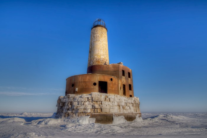
Grand Island North Light, photo by Jeff Shook

The photo above is from the Grand Island North Light page at Terry Pepper’s Seeing the Light. Head over there for all kinds of information about one of Michigan’s lonelier lighthouses.

As Halloween is tomorrow, I thought I’d share the tale of a mysterious murder at North Light from the Center for U.P. Studies at Northern Michigan University.

On June 12, 1908 the body of 30-year old Edward S. Morrison, the assistant lightkeeper at North Light, was discovered in a small sailboat near Au Sable Point. Although identification took a while, since few of the local people knew him, it was definite once made. Morrison had a distinctive tattoo of thirteen stars on his left arm, leaving no doubt as to the identity of the remains. Initial reports said his head had been “battered almost beyond recognition” and that “the head and shoulders were fearfully crushed, as if battered by a club.” Inexplicably though, a coroners jury concluded death was due to exposure, thought to be caused by the rough weather on the 7th. A reported second coroners jury also examined the evidence and returned a verdict that the members were not able to tell how he died, but they had a strong suspicion of murder!

Morrison had been assistant keeper only six weeks when he met his death. A native of Tecumseh, Michigan, he joined the Lighthouse Service on May 1, 1908 and secured the assistant keeper’s appointment at North Light. Friends claimed he had a “bright and sunny disposition” and that he “didn’t have an enemy in the world.”

The keeper of the light was George Genery, a long-time veteran of the Service. Appointed to North Light in 1893, he had been the assistant keeper at Menagerie Island, Isle Royale from 1887 until his posting to Grand Island. It was later claimed he had trouble keeping his assistants since none lasted longer than a season. Working with Genery was said to be difficult at best. The keeper was in Munising on June 6 to get supplies.

Baffled by the discovery of Morrison’s body and the knowledge that the beacon had been dark for nearly a week, a delegation from Munising went out to the light. They discovered the supplies Genery had brought back from Munising still piled on the dock. An empty wheel barrow stood nearby and his coat dangled undisturbed on a hook in the boathouse. Morrison’s vest was hanging carefully on the back of a chair, his watch and papers safe in a pocket. Of the three boats normally kept at the station, reports differed whether two or only one was missing. The last official log entry was made on June 5, while the slate entry for the 6th was made in Morrison’s hand. Neither gave a clue to anything being amiss. Other than the untended lamp, all else was normal, without evidence of any unusual occurrence. Local volunteers manned the light until the service send a replacement.

Authorities immediately started a search for the missing keeper, but he had completely dropped out of sight. There were reports that five different men had seen him at various times in Munising between June 9 and 12, and that he was drinking heavily. His wife, living in town, claimed no knowledge of his whereabouts and did not seem overly concerned with his strange disappearance.

There were several theories proffered to explain the case. One said the two men had gone out to lift nets and that Genery had fallen overboard and drowned. Morrison, unfamiliar with a sailboat, then drifted about helplessly until finally perishing from exposure. Friends, however doubted such reasoning. They considered Morrison an expert sailor, and in fact he had previously owned a 32-foot sailboat on the Detroit River.

Another theory is based on their having been paid on the 6th; that they were attacked by one or more unknown assailants on the island, murdered, robbed and the bodies dumped into the sailboats and cast adrift. Morrison’s eventually made shore. Genery’s never did. Lonely to distraction, no better location for such a crime could be imagined. No one else was in the area to witness such a heinous deed. The nearest other occupant on the island was the Cleveland Cliffs game keeper, whose house was seven miles to the south. There was a story that a body was later discovered in the east channel, but it was apparently never identified so whether it was the missing keeper is unknown. Finding “floaters” was not that unusual, so no definite link between it and Genery was possible.

The third theory was that Morrison was murdered by Genery…

Read on for more and also have a look at Death at the Lighthouse by Loren Graham as reviewed by the Moonlit Librarian.

The photographer is Jeff Shook of the Michigan Lighthouse Conservancy, an organization that does great work in the preservation of Michigan’s lighthouses.

Riding the storm out with the Poe Reef Lightship

Poe Reef Lightship

Poe Reef Lightship LV62 riding out a storm on her station, courtesy the Lake Carrier’s Association

The Poe Reef Lighthouse page at Terry Pepper’s Seeing the Light begins with the story of the vessel that preceded the lighthouse:

Poe Reef lies just eight feet beneath the water’s surface between Bois Blanc Island and the Lower Peninsula mainland, and as such has long represented a significant hazard to vessels making their way through the Straits between Lakes Michigan and Huron.

In the early 1890’s the Lighthouse Board faced a vexing problem. Increasing vessel traffic created a need to install navigational aids at a number of offshore shoals and reefs. With Congressional funds increasingly difficult to obtain, and the costs of offshore lighthouse construction prohibitively high, the Board determined that the use of lightships to mark such hazards would be both significantly more expeditious and cost effective.

Unable to convince Congress to free up the funds for these lightships, the Board took the chance of redirecting an existing $60,000 congressional appropriation for a lighthouse off Peninsula Point to the purchase of four lightships.

In 1892 two contracts totaling $55,960 were awarded to the Craig Shipbuilding Company in Toledo for the construction of four lightships. Designated as Lightships LV59, LV60, LV61 and LV62, all four vessels were built to similar specifications. Framed and planked of white oak they measured 87′ 2″ inches in length, 21′ 6″ inches in the beam, with a draft of 8 feet. In a cost-cutting effort, the vessels were un-powered, outfitted with only a small riding sail carried on a short after mast. Equipped with a cluster of three oil-burning lens lanterns hoisted on their foremasts, each was also equipped with 6″ steam whistles and hand-operated bells for fog use. Work was completed on the four vessels the following year, and after sea trials, all four were commissioned by the Board and placed into service, LV59 being assigned to Bar Point, LV60 to Eleven Foot Shoal, LV61 to Corsica Shoal and LV62 to Poe Reef.

With the words POE REEF brightly painted in white on her fire engine red hull, LV62 was towed to Poe Reef by the lighthouse tender Marigold, and anchored on station to begin her vigil on September 29, 1893. For the next seventeen years LV62 spent every shipping season faithfully guarding the shoal. With the end of each shipping season, one of the lighthouse tenders would make the rounds of all lightship stations in the Straits area, and tow them into Cheboygan harbor for winter lay-up. While in Cheboygan, necessary repairs and improvements would be made in preparation for the following season. At some time in March or April, the ice would break up sufficiently to allow the vessels to be towed back to their stations to stand guard for yet another season.

Read on for another shot of this vessel and for more about the lighthouse that replaced the lightship at Poe Reef. Also have a look at these photos of Light Vessel 96, which took over for LV 62 from 1915-1920 at Poe Reef.

One of many at Forty Mile Point

EDIT: WOW!! Check out the video that Tudor did at Forty Mile Point, The Grand Hotel and Fort Mackinac!

2013_10_11-WTA-5DM3-4448

2013_10_11-WTA-5DM3-4448, photo by Tudor ApMadoc

Wikipedia’s U.S. Lighthouses entry says that the United States has had approximately a thousand lights as well as light towers, range lights, and pier head lights. With the second longest coastline in the U.S. and a history of vibrant trade across the Great Lakes, it makes sense that Michigan has the most lights of any state with over 150 past and present lights (166 by their count and as many as 247 by some). While the current number varies depending on who you talk to, 115 seems to be the accepted number.

Terry Pepper’s Seeing the Light is a fabulous guide to the lighthouses of the Great Lakes and definitely a resource to review before you visit a Michigan lighthouse. The Forty Mile Point Light entry in explains:

While the Presque Isle Peninsula had been lighted since 1840, and the entrance to the Cheboygan River fifty miles to the north had been lighted since 1851, the New Presque Isle Light’s range of visibility of 19 miles and the Cheboygan Light’s visible range of 13 miles left an unlighted 18 mile intervening stretch of coastline along which mariners were forced to navigate blind. In it’s annual report for fiscal 1890, the Board recommended that $25,000 be appropriated for the construction of a new light and fog signal at Forty Mile Point near Hammond’s Bay, at the approximate mid point between the two lights.

(the project languished for nearly 60 years until…)

Eleventh District Engineer Major Milton B. Adams selected and surveyed the site for the new Light. With an offer of $200 for the property accepted by the owner, Adams approved the plans and specifications for the station in February 1896. Contracts for the ironwork for the lantern, gallery, boilers and fog whistles were awarded soon thereafter, and with receipt of the materials at the Detroit depot, were loaded aboard the lighthouse tender AMARANTH and delivered to the site on July 5, 1896. Work at the site began with the construction of a wood-framed building, which would be used by the work crew as a temporary dwelling during construction, and converted into a barn for the keeper’s horses on the completion of the work.

Adams’ plan for the main lighthouse structure was a virtual duplicate of that simultaneously under construction at Big Bay Point on Lake Superior. Consisting of a duplex dwelling with a tower incorporated into the center of one side-wall, the structure stood 35 feet by 57 feet in plan. Erected on a 20″ thick cut limestone foundation, the brick walls featured double walls with an air space between to provide insulation. The integrated tower stood twelve feet in plan, and fifty-two feet in height. The apartments on each side of the dwelling were exact mirrored duplicates and were set-up to afford complete privacy. Each apartment featured its own main entry, cellar, kitchen, parlor, tower entry door and stairway to the bedrooms on the second floor. Indicative of Adam’s thoughtfulness in designing the structure, each of the stairways incorporated a skylight in its ceiling through which the lantern could be observed, thereby allowing both keeper and his assistant to verify the correct operation of the light from within the warmth of their apartment without having to leave the building or climb to the top of the tower itself to see the light. The brick tower was capped by a square gallery with iron safety railing, and a prefabricated octagonal cast iron lantern erected at its center.

Read on for more at Seeing the Light and also check out this shot of the construction crew posing in front of the lighthouse in 1896. Forty Mile Point Light is now a museum, click here to visit their website for more including directions.

Check this photo out bigger, have a look at this panoramic shot of the light and see more in Tudor’s 2013-10 Fall Trip slideshow.

Many more Michigan lighthouses on Michigan in Pictures.

South Manitou Island Lighthouse

South Manitou Lighthouse

South Manitou Lighthouse, photo by HLHigham

Terry Pepper’s Seeing the Light is a tremendous resource for Michigan lighthouse information. His entry on the South Manitou Island Lighthouse begins:

Located just off the mainland coast of Lake Michigan’s east coast, a group of islands known as the Beaver Archipelago form a chain which marked the western edge of a tight passage along the coast. Known as the “Manitou Passage,” vessel masters taking this narrow passage were able to reduce the travel distance between the ports of Lake Michigan’s southern shore and the Straits of Mackinac by sixty miles, as opposed to taking the more circuitous route through open water to the west of the islands. As the most southerly of this chain of islands, South Manitou also featured one of the areas safest natural harbors, and with 5,260-acres of fine timber growth covering the island, it is not surprising that a few enterprising settlers arrived during the mid 1830’s to sell firewood to steamers taking shelter in the harbor when things turned sour out in the lake. By the late 1830’s it was commonplace to find upward of fifty vessels crowded into the harbor seeking refuge and taking-on supplies when things turned sour out in the lake.

Lying a scant few miles west of Sleeping Bear Point, mariners were hard pressed to locate the southern entrance to the busy passage at night or in times of thick weather, and a cry arose throughout the maritime community to light the southern entrance to the passage. Taking up their call on February 19, 1838, Michigan State Representative Isaac Crary entered a motion before the House of Representatives to erect a lighthouse on South Manitou, and fully cognizant of the vital role played by maritime commerce in the area, Congress responded quickly with an appropriation of $5,000 for the station’s construction on July 7 of that same year.

You can read on at Seeing the Light for the troubled saga of this light which saw high keeper turnover and some tragedy in its long tenure before being decommissioned in 1958. There’s also historical photos like this one showing the structure in full operation.

The light & South Manitou Island are now part of the Sleeping Bear Dunes National Lakeshore. Click that link for visitor information and also check out this satellite view of the South Manitou Light!

Check this out background bigtacular and see more shots of the light and the island in Heather’s South Manitou Island slideshow.

Many more lighthouses on Michigan in Pictures!