The word “equinox” comes from Latin aequus, meaning “equal,” and nox, “night.” On the equinox, day and night are roughly equal in length. (See more about this below.)
During the equinox, the Sun crosses what we call the “celestial equator”—an imaginary extension of Earth’s equator line into space. The equinox occurs precisely when the Sun’s center passes through this line. When the Sun crosses the equator from north to south, this marks the autumnal equinox; when it crosses from south to north, this marks the vernal equinox.
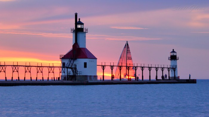
Scott took this photo on the final day of the summer of 2016 at the St. Joseph Lighthouse. See more in his massive Lighthouses gallery on Flickr.
This week I lost a friend & mentor, Greg Reisig. Greg was my publisher back in the 90s when I wrote for his Lake Country Gazette out of Elk Rapids. He was a man with an amazingly gentle soul who could nonetheless be fierce & determined in defense of Michigan’s environment. Bill Latka of Oil & Water Don’t Mix penned a great tribute to Greg, who was a board member of that organization & the co-chair of the Northern Michigan Environmental Action Council (NMEAC):
Since his early days as an environmental journalist and then for decades as a key protector of trees, water, and air for all of northern Michigan with NMEAC, Greg was a fearless yet gentle champion for the environment.
NMEAC has set up an endowment fund to create The Greg Reisig Prize for Environmental Journalism to celebrate his accomplishments. If you value the work that Oil & Water Don’t Mix is doing, you should know that Greg was a key part of it. I invite you to contribute to fund the awardso that future generations will know how much he made a difference every day.
His support of the campaign to shut down Line 5 brought a kind focus and keen sense of optimism for the work that kept us all going. He will be dearly missed.
Amen.
Mark took this photo last October at the the Wilcox-Palmer-Shah Preserve just north of Elk Rapids. More from Mark at downstreamer on Flickr.
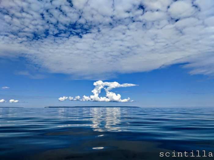
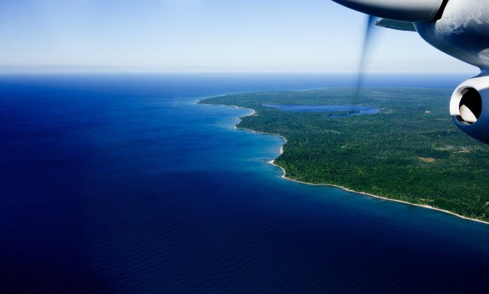
Here’s a simply stunning shot of North Manitou Island off the Leelanau Peninsula at the beginning of August. Leelanau.com says that North Manitou Island:
…is managed as wilderness with the exception of a 27 acre area around the Village. Visiting the island is a primitive experience emphasizing solitude, a feeling of self-reliance and a sense of exploration. The primary visitor activities are backpacking and camping. Travel in the wilderness area is by foot only. Power on the island is provided by a photovoltaic array located in the Village.
North Manitou Island is 7-3/4 miles long by 4-1/4 miles wide and has 20 miles of shoreline. The topography varies considerably on the island from low, sandy, open dune country on the southeast side grades to the high sand hills and blowout dunes on the southwest side of the island.
…2.5 miles of secluded Lake Michigan shoreline and 1,000 acres of steep slopes, rolling hills and fresh water coastal dunes more than 200 feet tall. The beach is a two-thirds mile hike from the picnic parking area.
The park’s major attraction are the long sandy beach and the 300-acre natural area, which contains a coastal dune system containing three endangered plant species. Nature enthusiasts, birdwatchers and hikers are the predominant day users.
The park, located in Allegan County, is relatively undeveloped. The land was acquired in 1971 from the Augustinian Order, who used the buildings as a seminary. When the state took ownership, the structures were used as a prison and state police offices.
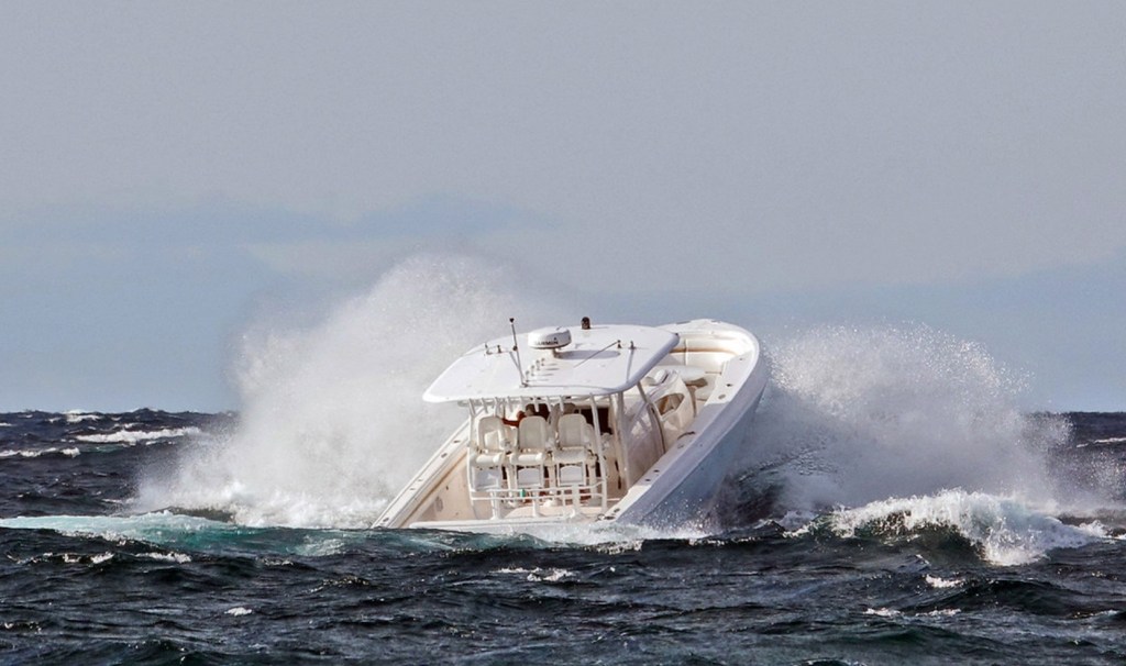
Sunday evening the winds picked up and we rode down to the pier and I watched this boat come from the harbor out the channel and head towards Petoskey north. He hit some huge waves coming in and I don’t know how he ever made it.
Here’s hoping he did and that you’re able to overcome the waves of 2020 as well!! See more in Julie’s Coronavirus Times 2020 album on Flickr.
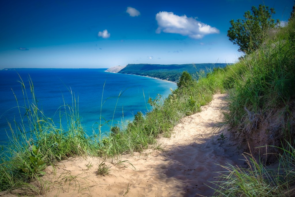
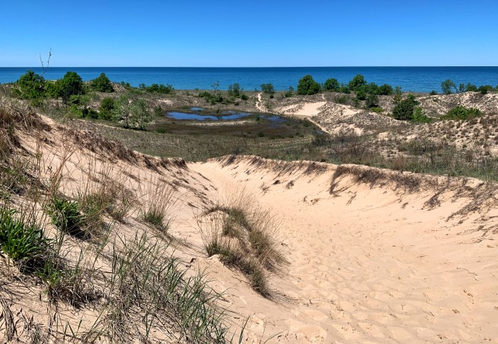
Mark took this beautiful photo a couple of summers ago on the Treat Farm Trail in the Sleeping Bear Dunes National Lakeshore. Guessing it looks much the same today, but you should check it out just to be sure! 😉
Head over to Mark’s Flickr for more & here’s the Park’s writeup on the trail:
The trail that leads from the corner of Norconk Road into the woods is about ½ mile long through the maple-beech forest and will take you to the Treat Farm. As you reach the top of the hill, the canopy of trees opens up to a view of the farmstead. A portion of the original barn has been rebuilt on the original foundation.
Visitors are drawn to this intriguing farmstead for several reasons. The trail leading up the slight incline from Norconk Road holds an allure of its own… it seems to beckon passers-by. It piques the curiosity by conjuring visions of what might be at its terminus. It is also one of the most beautiful areas for spring wildflowers in all of Michigan!
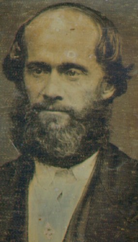
On July 8th, 1850, James Jesse Strang was crowned king of Beaver Island. Michigan History Magazine shared this article with me years ago:
Despite claiming to be “the perfect atheist,” Strang became a follower of Mormon leader Joseph Smith. When Smith was murdered in March 1844, Strang claimed to be the new Mormon leader, although most Mormons followed Brigham Young to Utah.
King James Strang (daguerreotype, 1856)
Strang’s followers settled on an uninhabited island in northern Lake Michigan they called Big Beaver. The island had everything Strang and his followers needed: virgin timber, tillable land, a deep and sheltered bay and exceptional offshore fishing. It also was twenty-five miles off the mainland-a perfect place to protect Strang’s followers from outside influences and beliefs.
By the mid-1850s, the Mormon colony on Beaver Island boasted more than 2,500 followers. Beaver Island replaced Mackinac Island as the principal refueling stop for steamers, and the annual value of the kingdom’s exports (fish, wood and potatoes) was considerable.
The growth of Strang’s kingdom was not without controversy. Non-Mormons, called Gentiles, took exception with the Mormon settlement. Driven from the area’s fishing spots, angry over the establishment of a kingdom and Strang’s adoption of the practice of polygamy, the Gentiles vowed revenge. At the bequest of President Millard Fillmore, the U.S. district attorney prosecuted Strang for an assortment of unfounded offenses that included murder and treason. However, Strang was acquitted on all charges, and a year later he was overwhelmingly elected to the state legislature.
Strang ruled Beaver Island as an autocrat; he even had himself crowned king. But regulating every aspect of his followers’ lives led to his downfall. Describing women’s clothes as impractical and unhealthy, Strang decreed female subjects needed to dress in loose, knee-length smocks worn over modest pantaloons. Most Beaver Island women accepted the change, but a few refused to comply. When two women refused to wear pantaloons, Strang had their husbands whipped. The two men sought revenge and on June 16, 1856, they ambushed and shot their king.
On July 9, 1856, James Jesse Strang died from his wounds. He was buried in Wisconsin.
With Strang gone, enraged Gentiles charged onto Beaver Island and evicted the Mormons. After taking control of the Mormon printing office, the attackers printed a manifesto that boasted, “The dominion of King Strang is at an end.”
…provides 1,952 acres of recreational opportunities along the beautiful shore of Lake Michigan in southwestern Michigan. The rugged dune formation rises 260 feet above the lake and offers spectacular views and excellent for hang gliding. The park has three miles of shoreline, six miles of hiking trails and is open year-round. Pet-friendly shoreline.
The dunes and beach area was preserved by a local businessman, Edward K. Warren, who originally purchased the site as a favor to a friend who had encountered significant financial difficulties. By 1930, the Warren Dunes area had been taken over as a state park
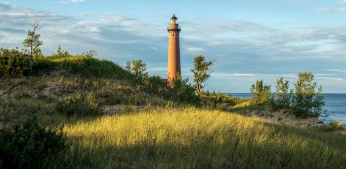
Congress appropriated $35,000 for the project, and 39 acres of land were selected on which to construct the new Light station. The construction of a light at Little Point Sable was destined to be a daunting task, since the location was distant from any area of supply, and there was a total absence of roads to the site. Work began in April 1873 with the construction of a dock at the beach and temporary housing for the construction crew.
A pile driver was towed to the point, and in accordance with Poe’s plan, 109 one-foot diameter pilings were driven into the sand to a level nine feet below the surface in order to form a solid base on which to build the tower. Twelve feet of cut stone was then carefully laid atop the pilings to provide a solid base for the tower’s brickwork. The brick walls had a thickness of five feet at the base, tapering to a thickness of two feet at its uppermost. With the advent of winter, the crews were removed from the point, and work had to wait for the next spring.
…Being built of a particularly hard and durable type of brick, the decision was made to leave both the tower and ancillary structures in a natural, unpainted condition, since it was expected they would withstand the rigors of the weather without deterioration. This was no doubt a decision which sat well with Keeper Davenport, as painting was an activity in which the authorities held considerable stock, and he found himself in the enviable position of not having that millstone around his neck every year!
…It did not take long before mariners began complaining that the natural brick coloration made the tower difficult to see during daylight hours. As a result, the tower was painted white on September 24, 1900, and thereafter, keepers assigned to the tower would be stuck with the drudgery of the annual painting ritual.
…With the station unmanned, the Coast Guard began to see the ancillary buildings as a liability, and in the first half of 1955 a crew arrived at the station and demolished everything but the tower.
The tower remained in its white painted condition until 1977, when once again seizing the opportunity to reduce the ongoing maintenance costs associated with constant painting, a crew arrived at the station, and sandblasted the tower. Once again, James Davenport’s easy ride was exposed to the light of day!