The Only Choice: Seul Choix

Boulder Splash - Seul Choix Point (Gulliver, MI)

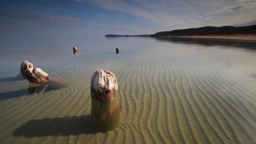
Boulder Splash – Seul Choix Point (Gulliver, MI), photo by Aaron C. Jors

Wikipedia’s entry for Seul Choix Light begins:

This location is the only harbor of refuge in a long and dangerous stretch of coast; the translation of the French name is “only choice” so it is clear that it was used as a refuge by the early French traders in this area. Local references state that the correct pronunciation is “Sis-shwa”, assumed to be the common name used by both the French Voyageurs and the Native Americans with whom they traded furs.

In the 1880s, there was increased maritime traffic between the harbors on Lake Michigan’s western shore and Green Bay on the one hand, and the Straits of Mackinac on the other. Although the St. Helena Island Light marked the western entry into the Straits, and Poverty Island Light lighted the entrance to the Bays de Noc, there were no lighthouses to aid mariners navigating a dark 100-mile (160 km) stretch of coastline on the southern shore of Michigan’s Upper Peninsula. The navigation season along this shoreline often began and ended with treacherous storms. Waves would build as they traversed the lake, making shelter a matter of life and death. Thus, mariners would seek shelter on the leeward side of points protruding into the lake along this stretch of unlighted shore.

You can read on for more and also check out The Haunting of Seul Choix Point Lighthouse on Michigan in Pictures for more about this lonely locale.

Check out Aaron’s photo bigger and see more in his Michigan slideshow.

Safety is always in style on Michigan’s beaches

Day at the Beach Grand Haven

Formal Day at the Beach 2012, photo by flambedude

Staying safe at the beach? There’s an app for that. The Great Lakes Echo recently reported on myBeachCast, a smartphone app that gives you beach information:

Although drownings appear to be on track to fall from a record high in 2012, the overall trend from the past several years have seen consistent increase, according to the Great Lakes Surf Commission. The hazard warnings on the app informs users when and where there is a potential for dangerous rip currents.

In addition to the hazard warnings, the app will continue to feature lake temperature, beach locations and other components.

“The app is GPS enabled to allow a user to discover local Great Lakes beaches based on their location, save favorite beaches and view real-time information [on conditions],” said Christine Manninen, communications director of the Great Lakes Commission.

The app will hopefully reduce drownings, she said.

“Having the information at their fingertips gives people a better chance of making smarter decisions to protect their own health and safety and their family’s.”

Jonathan writes that this photo was taken at Formal Day at the Beach, a yearly event in Grand Haven where people dress up and get into Lake Michigan and swim around looking fabulous. If anyone knows when this is in 2013 please post it in the comments! Jonathan just let me know that Formal Day at the Beach takes place this year on Sunday, July 28th at 2pm.

Check his photo out bigger and see more in his Formal slideshow.

Much more about Michigan’s beaches on Michigan in Pictures!

Good Harbor and Good Harbor Bay

Spring on Good Harbor Bay

Spring on Good Harbor Bay, photo by Eric Raymond

Good Harbor is located on the northern edge of Sleeping Bear Dunes National Lakeshore at the Lake Michigan end of County Road 651. Today only evidence of the vanished village are the pilings of what was once a 500′ dock that could load 4 schooners at a time. The Good Harbor page from the Lakeshore explains that logging in the area began in 1863 to supply cordwood fuel for  steamers, leading to the founding of a village in the 1870s.

Shortly after 1880 (Henry) Schomberg bought out Schwartz’s interest and built a big sawmill which had a capacity of 30,000 feet in a 10-hour day.

…The Schomberg Lumber Company ran a hotel, two stores which became a shopping center for the local farmers, and a saloon. The township line between Centerville and Cleveland townships ran down the middle of Main Street in Good Harbor. Centerville did not allow saloons, so Good Harbor’s saloon was built on the Cleveland township side of the street … At the height of the lumber business, the mill worked day and night during the winter and during the day in the summer. As many as 75 teams of horses were used hauling logs to the mill, lumber to the dock, and supplies to the camps. The lumber company owned some of the teams and the rest were owned by local farmers and rented to the lumber company. At its peak, the mill cut 8,000,000 board feet of lumber per year.

The schooners were loaded by farmers who were called to work at the dock when the ships arrived. Good Harbor had no protection from storms with a northwest wind, so ships had to leave the dock and sail to the Manitou Islands for protection when a storm would come up. Sometimes storms would come up too fast and the ships were driven aground.

You can read on for more and also see some of the wrecks in the area in the Manitou Passage Underwater Preserve.

Check this out bigger and see more great photos from the Sleeping Bear and Leelanau Peninsula (including another shot of the pilings by Terry Clark) on Eric’s Leelanau County Facebook page.

Walking on the beach

"Footprints" ,   Twelvemile Beach, pictured Rocks National Lakeshore - "Michigan Nut Photography"

“Footprints”, Twelvemile Beach, Pictured Rocks National Lakeshore, photo by Michigan Nut

“I’d rather do 20 miles on soft sand than 10 miles on the side of the road. There is something about being where water meets land. I feel very clicked-in there. I feel like I can go forever.”
~Loreen Niewenhuis

USA Today has a feature on Loreen Niewenhuis, a Battle Creek resident who has hiked a good deal of the shorelines of all the Great Lakes. As to why, she explains:

“Our older son had gone off to college. The nest was emptying. I’d gotten my” master’s of fine arts degree … “but I felt I could stack up novels and not have an agent and be in my office writing novels forever,” says Niewenhuis, 49. “So I thought, let me do something completely different and get out of my office.”

So she put on her hiking boots. She got out the office.

Boy, did she ever.

Click through to read more about her journey and what she learned along the way. You can keep up with Lorraine’s latest including a planned walk on 1000 of Michigan islands on her Facebook page and at laketrek.com.

This photo is of Twelve Mile Beach in the Pictured Rocks National Lakeshore on Lake Superior, certainly one of the state’s best beaches. Check John’s photo out on black and see more in his My Favorites slideshow.

Lakes Michigan, Huron, Superior & Erie? Michigan in Pictures has them and all kinds of beach photos!

Locally Known as “the Bowl”

Locally Known as "the Bowl"

Locally Known as “the Bowl”, photo by karstenphoto

EDIT: Wow I really messed this one up, sleepily citing an article that gave the dune’s age in the millions of years. Thanks to Tom Burrows for the catch. Let’s see if this information on coastal dunes from the DNR makes more sense:

Michigan’s glacial history provides an explanation for the formation of dunes. The Great Lakes dune complex is relatively young, in terms of geological time. As recently as 16,000 years ago, Michigan was covered with glacial ice thousands of feet thick. This glacial ice contained a mix of boulders, cobbles, sand, and clay. During glacial melting, this deposit was left and is known as glacial drift.

This glacial drift is the source of sand in most of Michigan’s dunes. The sands were either eroded from glacial drift along the coast by wave activity or eroded from inland deposits and carried by rivers and streams. Only the hardest, smallest, and least soluble sand grains were moved. Waves and currents eventually moved these tiny rocks inland, creating beaches along the Great Lakes shoreline.

…Blowouts are saddle shaped or U shaped (parabolic) depressions in a stabilized sand dune, caused by the local destabilization of the dune sands. Blowouts, which originate on the summit or windward face of a dune, are often rapidly formed by the wind, creating narrow channels and exposing plant roots. Blowouts can create interruptions in the shape of parallel dunes that may result in deeply carved indentions called parabolic dunes. It is the combination of interwoven parallel dune ridges and U shaped depressions, including parabolic dunes, that characterizes the classic dunes from Indiana, northward to Ludington, in Michigan.

Awesome Michigan wrote a little about The Bowl at Holland saying:

The Bowl is an gigantic sand bowl, resembling a sort of concave desert. Along with the other dunes and Lake Michigan itself, The Bowl was carved out of the earth by glaciers millions of years ago and was likely a small lake before drying up. Standing at the center of The Bowl and being surrounded on all sides by enormous walls of sand is quite breathtaking. The landscape is truly like no other. This awesome sight alone makes a trip to Laketown a summer necessity and a great, relaxing place to bring friends and family.

You can also check in there on Foursquare. Here’s another shot from the bowl from all the way back in 2007. Amazing to me how long Michigan in Pictures has endured – thank you all for staying with me!

Check Stephen’s photo out big as the Bowl and see this and many more in his FILM! slideshow.

More dunes on Michigan in Pictures.

Dogs vs Seagulls (and bacteria)

Untitled

Untitled, photo by jenny murray

The Great Lakes Echo has a feature on an Environmental Science & Technology journal report on how scientists have used dogs to rid a Lake Michigan beach of seagulls. Why do that you ask? While gulls are certainly part of the Great Lakes beach experience, seagull waste contains bacteria that harms water quality & sometimes closes beaches. The test took place in Racine, Wisconsin and they explain:

For eleven days researchers calculated the concentration of different bacteria on the Lake Michigan beach. They measured E.coli and Enterococcus concentrations to calculate fecal contamination. In addition, the study collected information on potentially pathogenic bacteria, which can cause infectious diseases.

Researchers then used two trained border collies with handlers to harass gulls while continuing to survey the water quality.

The dogs prompted the gull population to drop 98 percent, from nearly 670 birds to just fewer than 20.

Fewer gulls meant better water. E.coli bacteria decreased nearly 30 percent with the removal of half the gulls. Before the dogs started working, water samples tested positive for potentially infectious bacteria on seven out of eleven days. After the dogs chased the seagulls, researchers failed to find any contagious bacteria.

Read on for more about this innovative solution.

Check this photo of Dot out on black and see more in Jenny’s dot slideshow.

More beaches on Michigan in Pictures.

Michigan Shoreline Tour: Grand Mere State Park (and a flying dog)

My dog can fly

My dog can fly, photo by J. Star.

J Star writes:

The boy, the dog and I went to Lake Michigan yesterday, planning to stay until tonight. The forecast called for clear skies and eighty degrees for today…last night at about midnight the storms started. By morning, the thunder was deafening, the tent was afloat in three inches of water, and hail was pounding down everywhere. Needless to say, we packed it in early and headed home.

We did have fun on the beach for about two hours yesterday. Steve seems to think it was worth the drive. You can tell by the sand being joyously flung everywhere, and by the huge gob of it he left stuck to my polarizer.

The DNR page on Grand Mere State Park near Stevensville says that the 985 acre park features magnificent sand dunes, deep blowouts, one mile of Lake Michigan shoreline and three inland lakes behind the dunes in the undeveloped natural area. Both the DNR page and Wikipedia entry for Grand Mere State Park are remarkably scant on information, leading me to believe that with a 1/2 mile hike to the beach, it’s a pretty good place to avoid the crowds. Here’s a Google map to Grand Mere State Park.

Been there? Done that? Tell us or show us what it was like in the comments!