
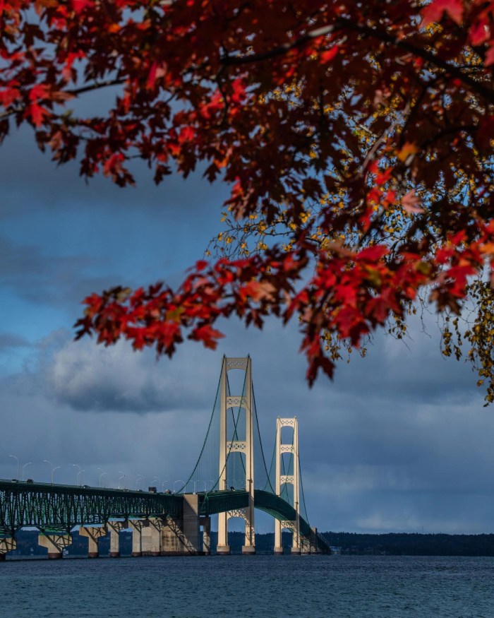
Mac & Trees by Noah Sorensen Photo
Here’s a shot with a banger of title from Noah. Head over to Noah’s Instagram for the latest!
PS: Dozens of photos & articles about the Mighty Mackinac Bridge on Michigan in Pictures.

Mac & Trees by Noah Sorensen Photo
Here’s a shot with a banger of title from Noah. Head over to Noah’s Instagram for the latest!
PS: Dozens of photos & articles about the Mighty Mackinac Bridge on Michigan in Pictures.
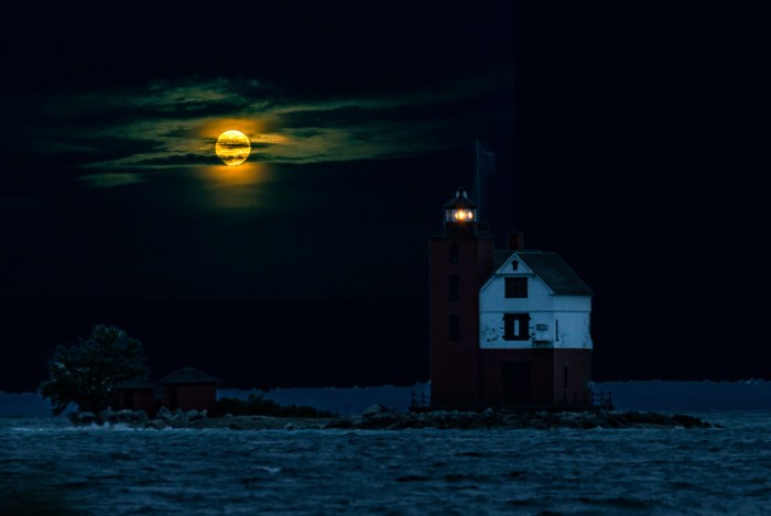
Round Island Light, with a little moon added for effect by Tom Clark
Tom’s shot of Round Island Light off Mackinac Island just might be the most Michigan Halloween photo ever. See more in his Night scenes & after dark images gallery on Flickr & head over to Tom’s website to explore his photos.
If you want a spooky lighthouse, check out The Haunting of the White River Light on Michigan in Pictures & happy Halloween everyone!!
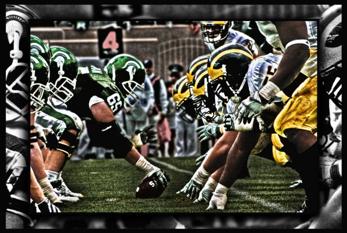
The undefeated & #6 ranked University of Michigan Wolverines travel to Spartan Stadium in East Lansing on Saturday to face the also 7-0 Michigan State University Spartans. First & foremost, let us know in the comments who you got this weekend!
mLive notes that the last time these two programs were top 10 with such a high profile meeting, the Beatles were touring America:
Saturday’s game between the Wolverines and the Spartans will be the first time in the 113-year history between these two state rivals that both teams are at least 7-0. It’s also the first game both teams have been ranked in the Top 10 since the same year The Beatles landed in the U.S.
The setting was East Lansing on October 10, 1964. Seventh-ranked Michigan took on 9th-ranked MSU in one of the biggest games in the decades-long rivalry, with Michigan winning 17-10 in front of 78,234 people. This was just the fourth game against each other where both teams were ranked in the Top 10.
…Michigan is favored by four over the No. 8 ranked Spartans. The Wolverines lead the all-time series 71-37-5.
Cory took this photo of the Spartans getting ready to punch it in back in October of 2009. MSU eventually won the game in overtime. See more in Cory’s HDR Photography gallery on Flickr & view and purchase prints on his website!
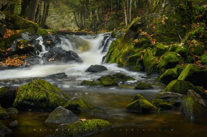
Travel the Mitten has a great entry on Kakabika Falls that says (in part):
The Ottawa National Forest covers more than 990,000 acres of Michigan’s Upper Peninsula and is a popular spot for outdoor recreation, camping, and wildlife viewing. The forest is also home to many waterfalls including Kakabika Falls, a set of cascades on the Cisco Branch of the Ontonagon River. These falls can be reached by a short drive north of the Watersmeet/Marenisco area, and a short, easy hike into the woods. The setting here is peaceful and there is a good chance you won’t encounter other travelers when you visit.
The tallest drop of Kakabika Falls is maybe 8 to 10 feet (most of the drops range from 1 to 5 feet), but this waterfall is more about the sum of its multiple drops than one large drop. The river makes a series of S turns here, and the trail closely parallels the river providing many great vantage points of each drop. As is the case with most waterfalls of this size, it is always best to visit in the spring or after decent rainfall. In dry summer months, we have found that there was barely any water flow here.
Click through for more including photos, map & directions from a really excellent website for Michigan travel ideas!
Neil shared that this is one of the many magical places in the Michigan’s Upper Peninsula, something that one look at his Instagram is all you need to see the truth in that! You can also follow Neil Weaver Photography on Facebook and view & purchase prints (including this one) on his website.
Many (many) more Michigan waterfalls on Michigan in Pictures!
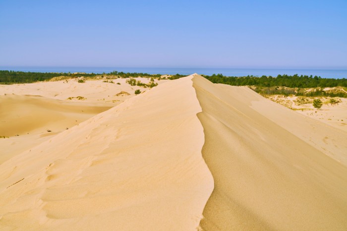
I’m Feeling A Little On Edge Today by David Hoffman
David took this shot of the incredible edge at the Silver Lake Dunes overlooking Lake Michigan. See more in his Silver Lake Dunes gallery on Flickr!
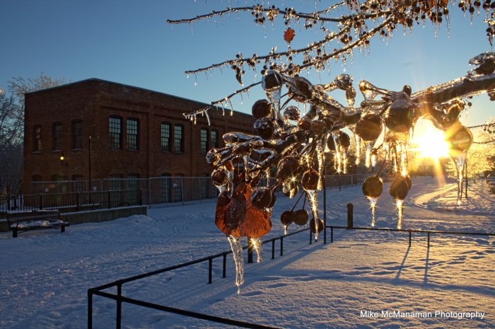
Water Street During an Ice Storm by Mike McManaman
The National Oceanic & Atmospheric Administration (NOAA) has issued their 2021-2022 winter weather outlook for the US. The NOAA Winter Outlook covers December 2021 through February 2022 and notes that with the La Nina weather pattern, Michigan & the Great Lakes are expected to see warmer & wetter than average conditions. Head over to NOAA for more including weather maps.
Mike took this photo on Flint’s Water Street after an ice storm back on Christmas Eve 2014. See more in his Flint, Michigan gallery on Flickr.
Fall Color from Sugar Loaf by Andrew McFarlane
Every so often I like to sprinkle in one of my own photos on Michigan in Pictures, and today is one of those days! I took this photo on October, 22, 2018 at the long-shuttered Sugar Loaf Resort on the Leelanau Peninsula. The ski run was called Devil’s Elbow, and you can see Little Traverse Lake, Lake Michigan, and South Manitou Island & Pyramid Point in the Sleeping Bear Dunes National Lakeshore (shout out to the Lakeshore for yesterday’s 51st birthday!)
While the color isn’t as spectacular this year as 2018, it’s still pretty nice. Also, fun fact: when I was 11 years old an out of control man ran me off the left side of the Elbow. I slid over 100′ down a very steep hill, broke my arm & had to be pulled out by a rope with a snowmobile by the Ski Patrol. You know I was right back at it as soon as the arm healed!!
If you want to read the long & depressing saga of the ski area, head over to Sugar Loaf Resort on Leelanau.com!
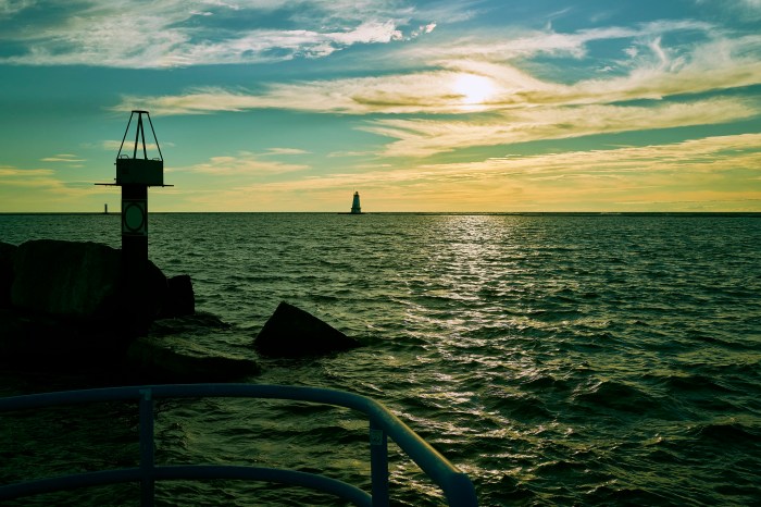
The Magic Of That Day Was Written In The Sky by David Hoffman
Sweet shot of the view of Lake Michigan from Ludington. See more in David’s Lighthouses gallery on Flickr!
Have a great weekend everyone & see more lighthouses on Michigan in Pictures.
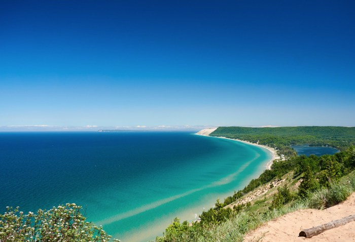
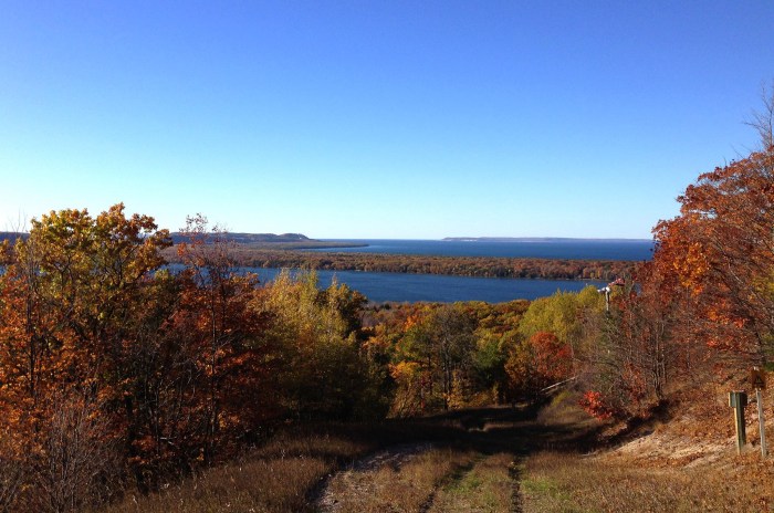
Sleeping Bear Dunes National Lakeshore by Thomas DB
(via leelanau.com) On October 21st, 1970 the Sleeping Bear Dunes National Lakeshore became the third US National Lakeshore. The online book A Nationalized Lakeshore: The Creation & Administration of the Sleeping Bear Dunes National Lakeshore has a good overview of what was a remarkably contentious issue back in the day:
Beginning in 1919 a small portion of what is now the national lakeshore was set aside as a state park. The idea of a national park in northwestern Michigan did not surface until the National Park Service’s Great Lakes Shoreline Survey visited the area in 1958. Between 1959 and 1970 there was a continuous and controversial effort in Congress to create a park unit around the Sleeping Bear Dune. The legislative leader of the Sleeping Bear park proposal was United States Senator Philip A. Hart. The senator’s persistence and patience in the end led to the creation of Sleeping Bear Dunes National Lakeshore on October 21, 1970.
Opposition to the creation of the lakeshore was very strong among local summer homeowners. More than 1,400 tracts of private land had to be acquired to create the lakeshore. A heavy-handed, poorly planned land acquisition program reinforced the bitterness that surfaced during the decade of struggle that preceded authorization. The legacy of those actions has been twofold. On one hand the National Park Service has been vilified by many local property owners and the park staff have had to work in an environment that is unnecessarily confrontational. On the other hand, the presence of an organized local populace wary of National Park Service policy has influenced for the better the development of the national lakeshore. Local sentiments played an important role toning-down the agency’s initial plans to intensively develop the area’s recreational assets. More recently local sentiment has influenced the agency’s approach to the lakeshore’s rural cultural landscapes. Unfortunately, resistance to the National Park Service in the region has also hindered opportunities to bring more land under protection and to develop scenic drives for park visitors.
The National Park Service conceived the Sleeping Bear Dunes lakeshore at a time when the shores of Lake Michigan were rapidly undergoing privatization. Subdivisions of vacation and year round homes threatened to keep ordinary citizens from enjoying Michigan’s broad, sandy shoreline. A nationalized lakeshore along the beaches and bluffs of the Sleeping Bear made available for all what might have been enjoyed only by a select few. The cost was millions of dollars of federal funds and the hopes and dreams of hundreds of small property owners. Sleeping Bear Dunes was a tragedy for the latter and a wise investment of the former.
Indeed. You can read lots more in A Nationalized Lakeshore.
It was hard to pick a photo for this post, but I ended up going with Thomas’s beautiful shot from June of 2016 of my favorite view in the Lakeshore atop the Empire Bluffs where you can see South Bar Lake, the southern end of the main dune complex, and the Manitou Islands in the distance. See more in Thomas’s 6/1-6/3/16 Grand Traverse & Leelanau gallery on Flickr.
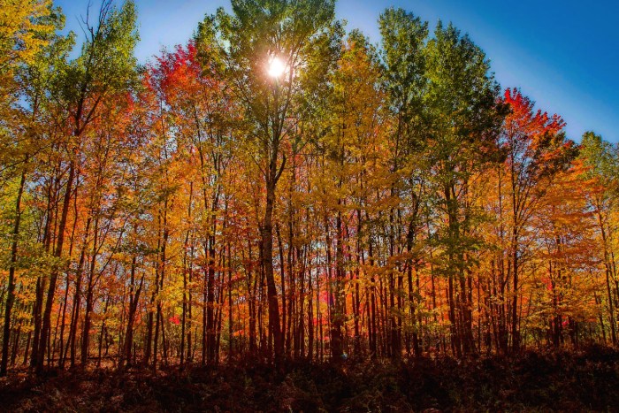
Sunlight through the autumn trees by T P Mann
Fall color remains in full swing across much of Michigan. Here’s hoping you have a chance to enjoy it before it’s gone!
T P took this photo way back on October 20, 2007. See more in his Michigan Autumn Colors gallery on Flickr.
More fall color on Michigan in Pictures!
