The Great Storm of 1913 and the Charles S. Price

charles-s-price-great-storm-1913

I’ve featured the worst storm in Great Lakes history before, but ThumbWind has a cool feature on The Great Storm of 1913 that includes some interesting information and photos. It says in part:

…the most savage storm in the history of the Great Lakes swept the inland waters November 7-12, 1913 resulting in much greater loss of life. Combined of the forces of two storm fronts colliding with hurricane force bringing monstrous waves and driving snow and ice that doomed anyone caught out on the big lake. The greatest losses in lives and ships occurred on Lake Huron where 24 vessels were lost or severely damaged. 10 ships went to the bottom of the lake.

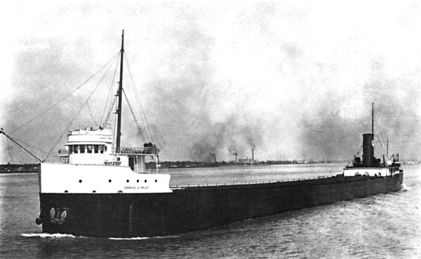
…On Lake Huron big freighters were tossed about by winds blowing from seventy-five to eighty miles an hour. One of these steamers was the Charles S. Price which received more space on the front pages of newspapers than any other ship. On Saturday morning, the Price, laden with soft coal, left Ashtabula, Ohio. When the freighter passed the town of St. Clair before dawn on Sunday morning, November 9, Second Mate Howard Mackley gave a short blast of the whistle as a signal to his young bride that he was passing and in reply she turned on an upstairs light in their home. By dawn the Price was making its way up Lake Huron. About noon Sunday the Price was seen north of Harbor Beach by Capt. A. C. May of the Steamer H. B. Hawgood.

On Monday afternoon a big steel freighter was seen floating upside down in the lake about eight miles north and east of the mouth of Lake Huron. Many people were anxious to learn the name of the steamer, although it was generally believed to be the Regina. On Wednesday morning an attempt was made to find out the identity of the vessel, however, owing to the high sea the diver did not make his descent. Lake Huron kept its awful secret for almost a week. It was not until Saturday morning, November 15, that William H. Baker, a diver from Detroit, solved the mystery. When he went down he read the name of the steamer twice and the letters spelled out Charles S. Price. The forward part of the bottom of the ship was buoyed up by air that was held in her when she turned turtle, but two streams of bubbles were coming out of the bow which meant that she would settle gradually. On Monday morning, November 17, the Price disappeared from view.

Read on for much more and follow Thumbwind on Facebook too!

More Michigan shipwrecks on Michigan in Pictures.

Pier Energy at Frankfort North Breakwater Lighthouse

pier-energy-by-aaron-springer

Pier Energy, photo by Aaron Springer

The Frankfort North Breakwater Lighthouse entry at Terry Pepper’s excellent Seeing the Light says the tip of the light is 72 feet off the water, making that spray over 80′ tall!! Click above for a ton more, but here’s something about the light tower:

1912 saw significant a significant change in the lighting of the Frankfort harbor entrance. A new square steel pyramidal tower was erected on the North Pier. Fully sheathed in steel plates, the white painted structure stood 44 feet from its base to the top of the ventilator ball. Outfitted with a fixed red Fourth Order Fresnel lens, the tower’s location on the north pier provided the new light with a focal plane of 46 feet, and a visible range of 12 miles in clear weather. The air siren from the South Pierhead light was relocated into this new structure, and set up to emit a characteristic isophase characteristic of alternating periods of 3 second blasts and 3 seconds of silence. An elevated walkway, similar to that installed on the south Pier, was erected from the new light to the shore.

…By 1924, the total car ferry tonnage through Frankfort Harbor was twenty five times greater than that prior to the establishment of the ferries. To better serve this vital commerce, the Army Corps of Engineers began construction of a pair of reinforced concrete arrowhead-type breakwaters at the harbor entrance in order to create a large stilling basin to protect the opening into the harbor. With the completion of these breakwaters in the early 1930’s, the twin piers at the entry into Lake Betsie no longer served any purpose. With plans in place to shorten them into short stub piers, the North Pierhead Light was lifted from the pier onto the deck of a barge and carried out to the end of the North Breakwater. A square steel base 25 feet in height had been erected on the end of the breakwater to receive it, and the tower was lifted onto the new base. After being bolted into position, the new tower stood 67 feet in height from the upper level of the pier to the top of the lantern ventilator ball. By virtue of its location on the concrete pier, the light stood at a focal plane of 72 feet, and the 17,000 candlepower incandescent electric light within the Fourth Order Fresnel was visible for a distance of 16 miles in clear weather.

Read on for lots more about the lighthouse including some great old photos.

View Aaron’s photo bigger and see more in his slideshow,.

Tons more lighthouses on Michigan in Pictures.

Fury Approaches

Fury Approaches

Fury Approaches, photo by Jamie MacDonald

Pow!

View Jamie’s photo from Kirk Park Beach in West Olive bigger, see more in his Stormy Weather slideshow, and visit jmacdonaldphoto.com for more of his work.

The Vortex: Roll cloud over Lake Michigan

Vortex Cloud

The Vortex, photo by Nick Nerbonne

My corner of Northern Michigan was all abuzz last weekend due to a relatively rare meteorological phenomenon known as a “roll cloud.” Wikipedia’s entry on Arcus clouds explains:

An arcus cloud is a low, horizontal cloud formation. Roll clouds and shelf clouds are the two types of arcus clouds. A shelf cloud is usually associated with the leading edge of thunderstorm outflow; roll clouds are usually formed by outflows of cold air from sea breezes or cold fronts in the absence of thunderstorms.

…A roll cloud is a low, horizontal, tube-shaped, and relatively rare type of arcus cloud. They differ from shelf clouds by being completely detached from other cloud features. Roll clouds usually appear to be “rolling” about a horizontal axis. They are a solitary wave called a soliton, which is a wave that has a single crest and moves without changing speed or shape.

View Nick’s photo background bigscroll through his pictures on Facebook, and watch this time-lapse of the cloud…

June 8, 1953: Remembering the Flint-Beecher Tornado

via Absolute Michigan

Tornado Damage in Beecher

Tornado Damage in Beecher, courtesy Flint Public Library

“The noise sounded like two freight trains going over a trestle right over your head; it was an ugly roar. My wife said the noise when the house went was like a giant pencil sharpener working.”
-Tornado Survivor Robert Blue

The National Weather Service relates that the Flint-Beecher tornado was Michigan’s worst natural disaster in terms of deaths and injuries:

This was the last tornado to kill over 100 people in a single tornado event anywhere in the United States. On June 8th, 1953, 116 people lost their lives in the Flint-Beecher community, and 844 people suffered injuries. The Flint-Beecher Tornado was just one of eight tornadoes that occurred that horrible evening across the eastern portion of the Lower Peninsula. Those other seven tornadoes resulted in an additional 9 deaths, 52 injures, and damage stretching from Alpena to Erie.

The Flint-Beecher tornado was rated as an F5, the highest rating on the Fujita scale of damage. Winds were likely in excess of 200 mph as the 800 yard wide tornado moved on its 27 mile path through Genesee and Lapeer counties. Approximately 340 homes were destroyed, 107 homes had “major damage”, and 153 homes had “minor damage”. In addition farms, businesses and other buildings were destroyed and had damage. These totaled another 50 buildings destroyed and 16 with damage. The damage was estimated around $19 million (about $125 million adjusted for inflation).

So great a number were killed by the monstrous tornado that the National Guard Armory building, along with other shelters, was turned into a temporary morgue. The scene of bodies pouring into the Armory (as an intermittent light rain poured outside) was incredibly bleak and horrifying, especially for the families and friends of the victims. At least 100 people waited outside into the rainy night before they could move inside to try and identify the bodies.

Read on for more at Absolute Michigan.

See more in the Flint Public Library’s Beecher Tornado gallery and watch this video account from tornado survivors below.

More history and more from Flint on Michigan in Pictures.

Double Rainbow

Double Rainbow

Double Rainbow, photo by Your Hometown Photography 

I simply love Atmospheric Optics for nearly everything about lights in the sky. Regarding secondary rainbows or “double rainbows” they say that the secondary is nearly always fainter than the primary, with colors reversed and more widely separated:

Light can be reflected more than once inside a raindrop. Rays escaping after two reflections make a secondary bow.

The secondary has a radius of 51º and lies some 9º outside the primary bow. It is broader, 1.8X the width of the primary, and its colours are reversed so that the reds of the two bows always face one another. The secondary has 43% of the total brightness of the primary but its surface brightness is lower than that because its light is spread over its greater angular extent. The primary and secondary are are concentric, sharing the antisolar point for a center.

About this particular rainbow from April 2, 2016, Gerry writes: “Double rainbow from the other night after the storms. The weather in Michigan can change quickly, from rainbows to snow. Yep, that’s Michigan.” 

Indeed. View her photo bigger and follow Your Hometown Photography on Facebook for more.

More rainbows on Michigan in Pictures.

Whipped Up Waves for the Weekend!

Whipped Up

Whipped Up, photo by Terry Clark

mLive reports that big waves are expected for parts of Lake Huron and Lake Michigan this weekend:

High winds and an arctic air mass are set to hit Michigan this weekend, and gales are in the forecast for the Great Lakes as a result.

A gale warning for much of Lake Huron’s offshore waters, issued by the National Weather Service, is scheduled for 8 p.m. Saturday, April 2 to 5 a.m. Sunday, April 3.

Winds are expected to reach up to 41 mph from the northwest with gusts up to 53 mph. According to the warning, waves will build up to 13 feet tall with the potential for an occasional 19-footer. The largest waves in an area 5 nautical miles off shore and out are expected around 1 a.m. Sunday on Lake Huron.

If you want to tune in, check out NOAA’s Great Lakes Coast Watch and the Great Lakes Webcam page.

View Terry’s photo background big and see more in his Wintry Scenes slideshow.

More waves and more wild weather on Michigan in Pictures!


Five Things you need to know about Michigan: March Meltdown Edition

Grove

Grove, photo by Liz Glass

On my Absolute Michigan website, I have a favorite feature called Five Things you need to know about Michigan.  

1Please go out and vote in the Michigan primaries today. I am going to vote for Bernie Sanders because I feel that in Michigan and elsewhere working folks, retirees, students, and many more who have ended up on the short end of a globalizing, transforming world are hurting. It seems to me that many of those we have elected to represent us have forgotten that government can be a powerful force for the betterment of society and that when profits come at the expense of others, we all suffer. Please vote for whoever you want to, and I’d love it if you took some time today to remember that you are a part of your government.

2Wow. I had the chance to drive across Michigan yesterday, windows down, basking in near 60 degree temperatures and knowing that spring is on the way. Here’s hoping that the mercury stays moderate and our farmers, orchardists & vintners have a great growing season.


3Liz Glass took today’s photo. You can visit her at the Lake Street Market in Boyne City.  She shared today’s photo back in 2012 in the Absolute Michigan pool (where I get most of the photos for Michigan in Pictures). Liz wrote:

I’ve been saving some ice shots to sprinkle in during the warmer months. This is from March 15, when the ice on Lake Charlevoix had melted into a pack of splinters that could then be pushed into piles by the moving water. The color here is real. The low sun is bouncing the golden brown of the sandy lake bottom up through the ice mound, and the looser shards on top are picking up the shimmering silvers and blues of the water and sky.

View her photo bigger and see more in her crazy-awesome Ice slideshow.

4If you have a problem with me being myself, please consider not telling me to “stick to the photos” and instead follow another blog/person/path that doesn’t bother you. I love Michigan, I love Michigan in Pictures, but I am an actual person who believes as I believe and does what I do. I will continue to do this, and telling me not to will just upset us both.

5Congratulations! By making it to here, you can send me an idea for something about Michigan to feature. I can’t promise that I will be able to, but I can promise you that I will try and reply in any case. Just email me or post a comment below.

support Michigan in Pictures

News for the Nervous: Mackinac Bridge Driver’s Assistance Program

Mackinac Bridge Snow Winter

Mackinac Bridge, photo by Blondieyooper

Fun fact of the day: I have a mild fear of heights! While it’s not crippling enough to stop me from being able to drive over the Mighty Mac, I can definitely see where some people aren’t able to do that. For all of you, here’s a story (with a good video) about a little known service: The Mackinac Bridge Authority will drive you across!

The Mackinac Bridge Authority explains further:

The Mackinac Bridge Authority has a “Driver’s Assistance Program” that provides drivers for those uncomfortable with driving across the Mackinac Bridge. If you are traveling northbound, there is a phone at the south end of the bridge. Instructions for using the phone are posted in the phone box. If you are southbound, just ask a fare collector for assistance. There is no additional fee for this service.

The phone is located on the shoulder of I-75 just north of the Jamet Street exit to Mackinaw City (near Audies Restaurant). You do not need to exit the freeway. Just past the exit, you can pull over to the right and park on the shoulder. The phone box is located on the right-of-way fencing. The box is green and easily spotted. If this is still unclear, please call us at 906-643-7600.

View Blondieyooper’s photo background big and see more in her Gotta Love Winter slideshow.

Lots more about the Mighty Mac on Michigan in Pictures.

Back into the freezer, Michigan

Ice Palace Grand Haven Lighthouse

Winter Wonderland, photo by David Behrens

mLive meteorologist Mark Torregrossa says that severe & sustained cold temps plus heavy lake effect snow are coming to Michigan this week:

Most of the heavy lake effect this winter has come on a northwest wind. The lake effect this week will be brought by a more northerly wind. So the lake effect will fall closer to the Lake Michigan shoreline. The heaviest snow will likely fall in the far southwest corner of Lower Michigan from St. Joseph to Michigan City, IN and South Bend, IN. Also heavy lake effect should fall from Traverse City, Leelanau County and southward to just west of Cadillac.

The heaviest areas of lake effect snow should easily have 6″ of snow, with spots getting up to a foot of snow.

…No area will escape the deep cold. This cold snap won’t be like the other cold snaps this winter that only lasted a few days. This cold snap will start Tuesday and gradually get colder each day into next weekend. By the time temperatures bottom out this weekend, we’ll freeze with highs in the teens and low temperatures in the single digits above or below zero.

The wind will push wind chill temperatures down to -10° to -20° at times in the second half of the week.

David took this last winter at Grand Haven. Check it out bigger and see more in his Home Sweet Home slideshow.

More about the Grand Haven Pier Light along with a crazy photo of the waves that make these ice formations on Michigan in Pictures!