Our Great Lakes would be a lot less pretty with Asian carp

Lake Michigan near Brevort, Michigan

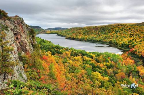
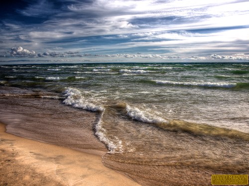
Lake Michigan near Brevort, Michigan, photo by daveumich

I tried to find something amazing about Lake Michigan – a poem, a legend, anything – but I really couldn’t find something to match up with this stunning photo. I’ll fall back on the real & urgent need to protect the beauty of Lake Michigan and the rest of the Great Lakes from the  very real threat of Asian carp.

Asian carp just suck: massive, leaping fish that seriously injure boaters and eat everything else in the lake. They would be an apocalypse for the $7 billion Great Lakes fishing industry, and it is estimated that just 20 fish getting in would be all it would take.

So of course, yesterday John Flesher (IMO the best environmental journalist in the Great Lakes who also happens to be my neighbor) wrote an article on Asian carp that begins:

The recent discovery of a large Asian carp near Chicago underscores the need to protect the Great Lakes from the voracious fish and other invasive species that could slip into Lake Michigan, two members of Congress said Tuesday.

“If Asian carp are not stopped before they enter the Great Lakes, they could destroy the ecosystem, as well as the boating and fishing industries, and hundreds of thousands of jobs,” said Sen. Debbie Stabenow, a Michigan Democrat.

…John Goss said the 53-inch, 82-pound fish was caught about a month ago in Flatfoot Lake, on the Illinois-Indiana state line.

Flatfoot Lake is landlocked and surrounded by a berm that would prevent it from flooding and enabling Asian carp to escape, said Chris McCloud, spokesman for the Illinois Department of Natural Resources.

But it’s very close to Chicago’s Lake Calumet, where commercial fishermen landed a 3-foot-long Asian carp in 2010 about six miles from Lake Michigan. Lake Calumet and Lake Michigan are connected by the Calumet River.

The latest find “is another reminder that we must find a permanent solution to protect the Great Lakes,” Rep. Dave Camp, a Michigan Republican, said Tuesday.

Indeed. How about we work on that? The Great Lakes are far too beautiful to be filled with the likes of Asian carp. If you agree, please share this with others. We can do something about this threat to our lakes.

Check this photo out background bigtacular, see more in Dave’s slideshow and also check out his photography website, Marvin’s Gardens including a shot of what I’m pretty sure was his breakfast up on Brevort Lake!

Regrettably, there’s more Asian carp on Michigan in Pictures.

Fort Mackinac

fort-mackinac-mackinac-island-mi-by-bill-johnson

Fort Mackinac, Mackinac Island, MI, photo by Wrong Main

Every once and a while I come across something about Michigan that I can’t believe I haven’t featured. Here’s the latest…

Wikipedia’s comprehensive entry on Fort Mackinac explains that the first fort on the Straits of Mackinac was Fort Du Buade. Built by the French around 1690 near the St. Ignace Mission, Du Bade was closed in 1697. In 1715 the French constructed Fort Michilimackinac on the south side of the Straits where Mackinaw City is today. Michilimackinac became the hub of the upper Great Lakes fur trade and a French outpost until 1761 when British soldiers took control after the French and Indian War.

The Mackinac State Historic Parks history of Fort Mackinac continues:

By 1776 the American Revolution was underway. With the successes of George Rogers Clark in capturing British posts in the south, and American forces moving northward, the British grew anxious that Fort Michilimackinac , a wooden fort built on the beach, was vulnerable. Consequently, British Commandant Patrick Sinclair chose to relocate the fort to Mackinac Island where the high limestone cliffs and good harbor provided a more defensible location. Between 1779 and 1781 many buildings were taken apart on the mainland and reassembled on the island. What was not moved was burned. The civilian community was built around the bay below the fort. One of the first new buildings to be built on the island was the Officers’ Stone Quarters, the oldest building in the State of Michigan today.

The fort and island became United States territory as a result of the American victory in the Revolution. However, it took thirteen years for American troops to arrive and finally take control of the fort from the British. The latter were reluctant to leave the island, as British merchants continued to dominate fur trading, even in American territory. After leaving Fort Mackinac in 1796, the British went to St. Joseph’s Island, at the mouth of the St. Mary’s River and established Fort St. Joseph .

War broke out between the United States and Great Britain in the summer of 1812. Under the cover of darkness, a 300-man force of British soldiers and Native American allies embarked from Fort St. Joseph and landed on the north shore of Mackinac Island . They dragged their cannon to the high ground behind the fort, took positions in the woods and prepared to attack. American soldiers, about 30, were completely surprised and outnumbered by the British invasion. They quickly surrendered without a fight following a single warning shot by the British. This was the first land engagement of the War of 1812 in the United States .

You can read on to learn how the Americans ultimately got the fort back and how became a center of the Great Lakes fishing industry, its time as a Civil War prison, and the hub of the second national park in the U.S., Mackinac National Park. If you want to visit – bear in mind they close for the season October 13th!

Bill took this shot October 1, 1982 on Plustek OpticFilm 7600. Check it out background big, see more in his slideshow and definitely click to view his photo of the Mackinac Bridge taken on the same day.

More Mackinac on Michigan in Pictures, and get a little bit more about Michigan’s role in the War of 1812 in The Battle of Lake Erie.

Set your course for Fall

Autumn Day at Lake of the Clouds

Autumn Day at Lake of the Clouds, photo by John McCormick/Michigan Nut Photography

John McCormick comments that it won’t be long and we will be seeing scenes like this one again. With a north wind blowing and highs not expected to reach 60 today in Michigan’s northern half, it’s pretty clear that fall and fall color is right around the corner! I hope you get the time to plan a color tour or two to enjoy places like the Lake of the Clouds. Michigan is especially amazing when the hardwoods catch fire, and the show only comes once a year

John is one of my favorite photographers, and his Michigan Nut Facebook page is on fire right now with new photos every day!

Load up with Fall colorFall wallpaper on Michigan in Pictures.

The Coves

The Coves Pictured Rocks

The Coves, photo by Gary of the North(Footsore Fotography)

Today’s photo is the latest cover for the Michigan in Pictures Facebook. It was taken at a beach known as The Coves in the Pictured Rocks National Lakeshore and is one of those photos to show your friends who don’t know Michigan.

Check it out background bigtacular and see & purchase more in Gary’s Pictured Rocks gallery at Footsore Fotography.

More great beaches on Michigan in Pictures!

Grand Mere Dunes is cooler than you think

Grand Mere Dunes

Grand Mere Dunes, photo by mswan777

Grand Mere State Park is located on the southwestern shore of Lake Michigan near Stevensville. The Environmental Protection Agency’s Sand Mine Restoration Plan explains that Grand Mere:

…contains some of the most unique sand dune features in the world. The park also contains three lakes, called North, Middle, and South Lake, and has over one mile of Lake Michigan frontage. The sand dunes within the park are part of the largest freshwater dune system in the world, lining the shores of the Great Lakes. These dunes historically supported a wide array of natural communities, including dry-mesic southern (oak-hickory) forest, rich conifer (cedar) swamp, southern (mixed hardwood) swamp, wetpanne and interdunal wetland (shrub swamp/emergent marsh), open dunes, and a wooded dune and swale complex.

The dunes at Grand Mere fall within a state-designated “Critical Dune Area.” The area containing the present-day park was also designated a National Natural Landmark in 1968. The park was first created on 393 acres of land in 1973, and more than doubled in size with the acquisition of 490 additional acres in 1986. The master plan for Grand Mere State Park, approved in 1986, cited “sand dune preservation” as the primary management objective for the park. A highly diverse flora exists at Grand Mere, with over 550 species of plants documented within the park. Furthermore, Grand Mere lies in a unique place on the southern shore of Lake Michigan where plants typical of both northern and southern temperate latitudes grow together in the same community. Because of the unique flora, fauna, and geology of the dune and wetland features at Grand Mere, the park has long been used as an “outdoor laboratory” for natural resource teaching and research.

…Within the park, the dominant landforms are the sand dunes along the shore of Lake Michigan. A large  bay of the glacial Great Lakes was present where Grand Mere State Park is today. During Algonquin  Great Lakes time (roughly 12,000 years ago), a large spit formed from the south along the west side of the  bay, nearly cutting it off from the glacial lake (Tague 1947). Most of the dunes at Grand Mere formed on  this Algonquin sand spit during the later Nipissing Great Lakes period, approximately 4,500 years ago.  During the more recent post-Algoma period (3,000 years ago until present), a smaller spit from the north  merged with the larger, dune covered southern spit, closing off the bay. As water levels fell, five lakes  formed in this bay. The two southern lakes have subsequently filled in and have become the present-day  tamarack swamp south of South Lake. While the lakes were forming in the bay as water levels fell, some  smaller foredunes were formed along the shoreline of Lake Michigan. The topography and sandy soils of  the park can be attributed to this glacial history.

Read on for more about the history & geology of this unique park, and check out Grand Mere State Park on the Absolute Michigan Map.

View Mark’s photo background big and see more in his Michigan –  Color slideshow.

More dunes on Michigan in Pictures.

Quincy Dredge No. 2 is actually C&H Dredge No. 1

signature

signature, photo by Marty Hogan

The Copper Country Explorer has an excellent feature on The Mining of Torch Lake begins:

Early stamp methodology was a very simple and archaic one – nothing more than a simple process of smashing rock down into small pieces and sorting out the copper. Everything that remained would then be dumped into tailing ponds as waste. In the Copper Country the largest of these tailing ponds was Torch Lake, where no less than five mines dumped millions of tons of waste rock into its depths. Unfortunately, these waste tailings often contained a great deal of copper which the jigs and wash tables of the mills failed to remove. Copper that ended up in Torch Lake.

As copper prices dropped and milling technology improved, mine companies began to take a second look at these copper bearing deposits in Torch Lake. It was now possible – and economically advantageous – for mines to retrieve those tailings and remove the copper that they still contained. The process was known as reclamation, and was first undertaken in earnest by C&H around 1920. Towards that end C&H built itself a dredge that could suck up those sands from the lake bottom and send them out to the reclamation plant on shore. This first dredge – known as C&H Dredge No. 1 – would be responsible for retrieving over 48 million tons of C&H sands in its lifetime, yielding over 423 million pounds of copper for the company.

The Quincy Mine got into the reclamation game several decades later – in 1943 – after failing to make a profit on its underground operation. In 1953 the C&H Dredge No. 1 was bought by Quincy to supplement its own dredge. It turned out to be exceptional foresight, as Quincy’s first dredge ended up sinking in Torch Lake in 1956. Its roof top can still be seen sticking up from the center of the lake. As for Quincy Dredge No. 2, it continued to mine Torch Lake for several more decades until it too sank in 1967.

Read on for a detailed account of the workings of the dredge, lots of views of the dredge and some great historical photos.

Check Marty’s photo out background big and see more in his 2012 August Road Trip slideshow.

More Michigan industry on Michigan in Pictures.

2013 Mackinac Bridge Walk … and a chance to get to the top of the bridge!!

FULL

FULL, photo by ddt_uul

The annual Labor Day Bridge walk across the Mackinac Bridge takes place this Monday (September 2, 2013). UpNorthLive reports that you can turn your Labor Day bridge walk into a one of a kind experience with a trip to the top of the Mighty Mac!

More than 40,000 people are expected to participate in the 56th Annual Labor Day Bridge Walk which will take on Monday, Sept. 2.

For the second year in a row, the Michigan Department of Transportation and the Mackinac Bridge Authority are asking the public to share their Labor Day Mackinac Bridge Walk experiences on social media with photos and videos. One person sharing their memories will be chosen at random to receive a once-in-a-lifetime tour to the top of the Mackinac Bridge.

Through Monday, Sept. 9, you can post your memories of walking the bridge, either this year or in a previous year, on Instagram and Twitter using the hashtag #MightyMacWalk13. Memories can include photos or videos.

A lucky person whose entry is chosen at random by computer will receive a tour for two to the top of the bridge, courtesy of the MBA. The person who travels the furthest to walk the bridge this year and post a memory will win a Pure Michigan gift pack, courtesy of the Michigan Economic Development Corp.

Read on for more and check out the pics on Twitter and Instagram. Get all the details on the annual Mackinac Bridge Walk from the Mackinac Bridge Authority. If you want to see what it looks like from the top, check out my friend Spike’s Mackinac Bridge slideshow!

Dave took this shot on Labor Day, 2010. Check it out background big and see more in his great Mackinac Bridge Walk slideshow.

Much more on the Mackinac Bridge at Michigan in Pictures!

Ford-Wyoming Drive-in Theater in Dearborn

_MG_2576 tmlF

Ford-Wyoming Drive-in, photo by Gallopping Geezer

When I first saw this pic I thought it was yet another abandoned drive-in, but it turns out that the Ford Drive-in in Dearborn is open nightly with 5 screens! Their website just lists movies, but the Ford Drive-in entry at Cinema Treasures explains:

Opened in 1950, as a single-screener, with a colossal, late Streamline-style screen, the Ford-Wyoming could originally accommodate around 750 cars. It also once advertised a kiddie playground and boat rides for children.

The drive-in was acquired by Wayne Amusements in 1981, and by 1990, and grown to five screens. Another four screens were built during the early-1990’s.

Today, the still-very popular drive-in is the largest in the United States, parking-wise, with space for over 3,000 cars. (The largest drive-in screen-wise is the Thunderbird in Fort Lauderdale, Florida with 13 screens).

The Ford-Wyoming is open year-round, a rarity for drive-ins, and supplies car heaters along with speakers during the winter season.

Screens 6-9 were closed and demolished in May 2010, and in June 2010 it was renamed Ford Drive-In

WaterWinterWonderland has an entry with tons more information and photos  of the Ford-Wyoming Drive-in including some nice aerial views.

Check Gary’s photo out big as a drive-in screen and see more in his Ford-Wyoming slideshow.

More Michigan movie pics on Michigan in Pictures including a feature on another metro Detroit drive-in, the Wayne Drive-in.


Michigan Apples Bounce Back!

Red McIntosh apples

Red McIntosh apples, photo by vostok71

The Detroit Free Press writes that Michigan apples are back – and in a big way.

This year’s harvest could be one of the largest Michigan has ever seen, the Michigan Apple Committee said Friday after the U.S. Apple Association released its estimate for Michigan’s 2013 apple crop. The 30-million-bushel projection was welcome news after last year’s wacky spring weather devastated 90% of the overall apple crop, which yielded just 2.7 million bushels. The state averages about 20 million bushels a year, the committee said.

“Our growers, packers and shippers are already moving Michigan apples into the marketplace and are thrilled with the estimates for this year’s crop,” said Diane Smith, executive director of the Michigan Apple Committee, who was in attendance at the USApple announcement in Chicago. “There’s a lot of buzz around the estimate here in Chicago and in our state.”

The Apple Committee said a crop like this year’s could pump as much as $900 million into the state’s economy, and industry experts say perfect weather conditions are to thank.

Good news for everyone who was left cider-less and apple-less last fall! Read on at the Freep and get lots more about Michigan’s largest fruit crop from the Michigan Apple Committee or their Facebook page.

Last year I used a photo Sergei took of the Wolf River apple (Michigan’s largest) on a post about our smallest crop ever, so it’s fitting to return to celebrate! Check his photo out background bigtacular and see more in his apple slideshow.

More apples on Michigan in Pictures.

Manabozho and His Toe … and his waterfall

Manabezo Falls.

Manabezo Falls., photo by one lost backpacker

The stories of the people native to Michigan are among my favorite. One reason is for the pervasive humor that enriches them. Manabozho was definitely a trickster, one of four divine brothers in Algonquin tales. Via the Literature Network, here’s Manabozho and His Toe:

Manabozho was so powerful that he began to think there was nothing he could not do. Very wonderful were many of his feats, and he grew more conceited day by day. Now it chanced that one day he was walking about amusing himself by exercising his extraordinary powers, and at length he came to an encampment where one of the first things he noticed was a child lying in the sunshine, curled up with its toe in its mouth.

Manabozho looked at the child for some time, and wondered at its extraordinary posture.

“I have never seen a child before lie like that,” said he to himself, “but I could lie like it.”

So saying, he put himself down beside the child, and, taking his right foot in his hand, drew it towards his mouth. When he had brought it as near as he could it was yet a considerable distance away from his lips.

“I will try the left foot,” said Manabozho. He did so and found that he was no better off, neither of his feet could he get to his mouth. He curled and twisted, and bent his large limbs, and gnashed his teeth in rage to find that he could not get his toe to his mouth. All, however, was vain.

At length he rose, worn out with his exertions and passion, and walked slowly away in a very ill humour, which was not lessened by the sound of the child’s laughter, for Manabozho’s efforts had awakened it.

“Ah, ah!” said Manabozho, “shall I be mocked by a child?”

He did not, however, revenge himself on his victor, but on his way homeward, meeting a boy who did not treat him with proper respect, he transformed him into a cedar-tree.

“At least,” said Manabozho, “I can do something.”

If you’d like more of Manabohzo, check out Manabohzo and the Ultimate Fish Story which might make you a bit more kindly disposed to seagulls.

Check out Randy’s photo background bigtacular and see more in his amazing Michigan Upepr Peninsula 2013 slideshow.

More about Manabezho Falls on Michigan in Pictures.