Opening the Mackinac Bridge, November 1, 1957

Opening of Mackinac Bridge - November 1, 1957

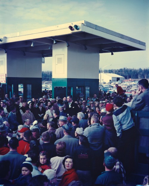
Opening of Mackinac Bridge – November 1, 1957, photo by daveumich

An Absolute Michigan feature via Michigan History Magazine on the opening of the Mackinac Bridge on November 1, 1957 says (in part):

With the bridge ready for traffic, but fearing inclement autumn weather at the Straits, officials decided to have an official “opening” on November 1, 1957, but an official “dedication” in late June of the following year.

Amazingly, the weather on the first day of November (preceded by two days of rain and fog) was sunny and pleasant. However, the weather in late June was so cold and wet (with six-foot waves on the Straits) that some of the events were shortened or canceled altogether. According to one observer, it “was a bleak, gray day, more like March than June, and the only parader who looked happy was a snow queen from Cadillac, who rode on an ice throne float, throwing snowballs made of popcorn.”

…On November 1, after paying the $3.25 toll (taken symbolically by former U.S. Senator Prentiss Brown, who chaired the Mackinac Bridge Authority), Governor G. Mennen Williams crossed the bridge (driven in a car by Mrs. Williams because the governor had forgotten his driver’s license). Then, according to United Press International correspondent Thomas Farrell, cars lined up for one mile on both sides of the Straits “swarmed” on to a bridge whose size “staggers the imagination.”

In his opening day remarks, Governor Williams predicted that the bridge would add $100 million annually to the state’s tourist trade. He continued, “Michigan at last is to be one state, geographically, economically and culturally, as well as politically.”

I think we can probably agree that it’s had a tremendous impact on Michigan! About this photo with a unique view of the festivities, Dave writes:

A friend found this large format color slide earlier this year and I scanned it at high resolution. It shows Governor G. Mennen “Soapy” Williams at the tollbooths on the St. Ignace end of the Mackinac Bridge on the day it opened, November 1, 1957. I have seen many photos of this day, but never one quite like this.

Be sure to check this out big as the Mighty Mac to see the faces in the crowd and jump into Dave’s slideshow for more.

Michigan in Pictures has lots more on the Mackinac Bridge and you can get a comprehensive look at the bridge on the 50 Year feature on the Mackinac Bridge at Absolute Michigan.

Miles of Fall Color from Landslide Overlook

Landslide Overlook 2

Landslide Overlook 2, photo by LindaB.

Fall is a time for exploration and seeing new sights. In precisely that spirit of adventure, Linda writes:

Just by looking at the map I said ‘lets take this dirt road and see what color we find.’ I didn’t know it was a seasonal road until we turned onto it and then saw a sign that said Landslide Overlook. So we followed this dirt road, which was rather narrow in spots, until we came to a parking area. It was just a short 1/4 mile walk to this wonderful view of the Jordan River Valley.

You can read more about the Jordan Valley from the DNR and get a map to the overlook on Foursquare.

Check Linda’s photo out background bigtacular and see a couple more shots from this incredible overlook in her slideshow.

More Fall wallpaper on Michigan in Pictures.

Roar

Roar

Roar, photo by Matt Gowing

Just sayin’.

Check Matt’s photo out background bigilicious and see more in his Street slideshow.

And oh yeah – go Tigers!

There’s always next year…

There's always next year....

There’s always next year…., photo by bill.d

Here’s hoping you get out and take in some of Michigan’s fall color & flavor this weekend!!

Check Bill’s photo out background bigtacular and see more in his Asylum Lake slideshow.

More fall wallpaper on Michigan in Pictures!

Fall at Spray Falls

Spray Falls Autumn Colors

Spray Falls Autumn Colors, photo by James Marvin Phelps

James took this photo four years ago today at Spray Falls in the Pictured Rocks National Lakeshore.

Check this out background big and see more great shots from the UP in his Michigan Fall Trip 2009 slideshow.

More about Spray Falls on Michigan in Pictures.

Northern Lights show better than expected!

Aurora over Torch Lake

Aurora over Torch Lake, photo by HLHigham

NOAA’s Space Weather Prediction Center posted Geomagnetic Storm Starts Early about 8 hours ago:

The awaited CME passed the ACE spacecraft around 0100 UTC on October 2 (9:00 p.m. EDT October 1), sooner than forecasters had expected. G1 (Minor) Geomagnetic Storming now prevails, with the prospects of G2 (Moderate) levels still to come. The shock had no effect on the current Solar Radiation Storm, still declining through the S1 (Minor) category. Aurora watchers in North America may want to check the skies in the next few hours.

Those who got out were rewarded, and there’s more on tap for tonight. With this strong on an aurora at Torch Lake, the might be visible tonight in Grand Rapids or even further south!

I posted a photo from Heather just a couple of days ago, but sometimes convention needs to take a back seat to beauty! Check this out background bigtacular and in her Night Sky slideshow. 

PS: Shawn Malone simply posted “Oh My” about an hour ago, so definitely take a look at her Lake Superior Photo Facebook later today when she’s had a chance to grab some shut-eye and post them!

Orange is the new … orange

Orange is the new orange

_JMC1593aw, photo by Jeff Caverly

Sunrise on the Saginaw River in Bay City.

Check Jeff’s photo out background big and see more in his slideshow.

More sunrises on Michigan in Pictures.

South Manitou Island Lighthouse

South Manitou Lighthouse

South Manitou Lighthouse, photo by HLHigham

Terry Pepper’s Seeing the Light is a tremendous resource for Michigan lighthouse information. His entry on the South Manitou Island Lighthouse begins:

Located just off the mainland coast of Lake Michigan’s east coast, a group of islands known as the Beaver Archipelago form a chain which marked the western edge of a tight passage along the coast. Known as the “Manitou Passage,” vessel masters taking this narrow passage were able to reduce the travel distance between the ports of Lake Michigan’s southern shore and the Straits of Mackinac by sixty miles, as opposed to taking the more circuitous route through open water to the west of the islands. As the most southerly of this chain of islands, South Manitou also featured one of the areas safest natural harbors, and with 5,260-acres of fine timber growth covering the island, it is not surprising that a few enterprising settlers arrived during the mid 1830’s to sell firewood to steamers taking shelter in the harbor when things turned sour out in the lake. By the late 1830’s it was commonplace to find upward of fifty vessels crowded into the harbor seeking refuge and taking-on supplies when things turned sour out in the lake.

Lying a scant few miles west of Sleeping Bear Point, mariners were hard pressed to locate the southern entrance to the busy passage at night or in times of thick weather, and a cry arose throughout the maritime community to light the southern entrance to the passage. Taking up their call on February 19, 1838, Michigan State Representative Isaac Crary entered a motion before the House of Representatives to erect a lighthouse on South Manitou, and fully cognizant of the vital role played by maritime commerce in the area, Congress responded quickly with an appropriation of $5,000 for the station’s construction on July 7 of that same year.

You can read on at Seeing the Light for the troubled saga of this light which saw high keeper turnover and some tragedy in its long tenure before being decommissioned in 1958. There’s also historical photos like this one showing the structure in full operation.

The light & South Manitou Island are now part of the Sleeping Bear Dunes National Lakeshore. Click that link for visitor information and also check out this satellite view of the South Manitou Light!

Check this out background bigtacular and see more shots of the light and the island in Heather’s South Manitou Island slideshow.

Many more lighthouses on Michigan in Pictures!

Kawkawlin River: the Place of the Pike Fish

Kawkawlin River

Kawkawlin River, photo by conradthedog

A Brief History of the Kawkawlin River from the Kawkawlin Watershed Property Owner Association says that the native name for Kawkawlin was U GUH KON NING or ‘place of pike fish’. They add that the Saginaw Treaty of 1819 was negotiated by Lewis Cass with the Chippewa Indians and opened the lands of Saginaw Valley to settlers for $1.25 per acre and have lots more history & information at the link above.

Check out Jon’s photo background big and see more in his Michigan slideshow.

Many more rivers on Michigan in Pictures.

Mendota Channel Light aka Bete Grise Lighthouse

Bete Grise Lighthouse by Steve Nowakowski

Bete Grise Lighthouse, photo by Steve Nowakowski

Terry Pepper’s Seeing the Light page for the Medota Channel Light says that in response to increasing industrialization around Lac LaBelle, a cut was created from the Lake Superior into Lac LaBelle to allow access to the big ships that plied the Great Lakes.

As a result, the construction of the Mendota Light was first considered by the US Congress in 1867, when an appropriation of $14,000 for the construction of a light station was approved on March 2, with the terms of the contract called for construction of the structure to begin in 1869, with final completion no later than November 1870.

Later that year, it was realized that declining industrial development in the area would no longer support the planned deepening of the cut into Lac Labelle, and it was deemed that the light would serve no purpose. Decommission was ordered, and instructions to dismantle the structure were issued to the crew of the steamer “Haze,” with all equipment to be returned to USLHS headquarters in St. Joseph for eventual reuse. (The lens and mechanics were later reused in the Marquette Breakwater light.)

Thus, the Mendota light station was decommissioned before it saw real service, and the structure sat idle and blinded for the following twenty two years.

In the following years, Great Lakes shipping increased dramatically, and many ships rounding the Keweenaw began using Bete Grise Bay as a shelter during rough seas. In 1892 it was determined that a reactivation of the Mendota light, along with relocation closer to the bay would make bay entry a far safer proposition for such ships seeking shelter. Authorization for reactivation was issued on February 15, 1893, and $7,500 was appropriated to cover the expenses.

Read on for more about this light.

Check Steve’s photo out background bigtacular and see more in his Bete Grise Lighthouse slideshow.

There’s lots more lighthouses on Michigan in Pictures and you might also want to check out the vantage from Bare Bluff on Bete Gris Bay!