Michigan’s First Lighthouse: Fort Gratiot Lighthouse

Fort Gratiot Lighthouse

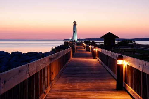
Fort Gratiot Lighthouse, photo by charles hildebrandt

Terry Pepper’s Seeing the Light is the go-to resource for Michigan lighthouses. His Fort Gratiot Lighthouse page begins:

The entrance into the St. Claire River from Lake Huron had long been deemed of strategic importance. Named after General Charles Gratiot, the engineer in charge of its construction, the Fort Gratiot military outpost was established at the entrance to the river in 1814, and ensured the security of vessels making the passage.

With the surge in vessel traffic on Lake Huron in the early 1800’s, the need for a lighthouse to guide vessels into the river and away from the shallows at the River entrance became a matter of increasing importance. In response to this need, Congress appropriated $3,500 to construct a lighthouse “near Fort Gratiot, in Michigan Territory” on March 3rd of 1823.

The contract for construction of the lighthouse and keepers dwelling was awarded to Captain Winslow Lewis of Massachusetts. Lewis was the inventor of the patented Lewis Lamp, which the Fifth Auditor had universally adopted as the primary source of illumination in the nation’s growing inventory of lighthouses. A staunch supporter and ally of the Fifth Auditor, Lewis had branched out into the business of lighthouse construction, and as the frequent low bidder, was being awarded a growing number of contracts to fulfill the nation’s need for navigational aids on the East Coast.

Lewis sub-contracted the construction of the tower and keepers dwelling that would become known as the “Fort Gratiot Light” to Mr. Daniel Warren of Rochester New York. Work commenced on the structure, but appears to have been running far beyond the scope of the original bid, since Congress appropriated an additional $5,000 for the project’s completion on April 2, 1825.

With the completion of construction on August 8th of that year, Fort Gratiot Light held the honor of becoming the first lighthouse in the State of Michigan.

Read on for much more including a couple of old photos of the light.

View Charles’ photo background big and click for more of his lighthouse photos.

Many more Michigan lighthouses on Michigan in Pictures!

Lake Superior Thunderhead

Lake Superior Thunderhead

Lake Superior Thunderhead, photo by Lake Superior Photo

So far this summer we’ve gotten some free fireworks show such as the storm that swept through last weekend. Shawn wrote:

It was fireworks over the lake last night, my dog was not pleased, however I was ecstatic. Lightning was going off a couple times a second and it did not let up, but stayed mostly in the clouds. I watched this for over an hour, and it just drifted by, stars overhead the entire time – go big screen to see the stars right top of frame.

So… what are you waiting for? Go background big and see more at Lake Superior Photo on Facebook.

Have a great weekend everyone!

Happy Fourth of July!

Bombs of Smoke And Confetti

Bombs of Smoke And Confetti, photo by Ross Ellet

Happy 4th of July everyone!

View Ross’s photo background big and see more in his Night Photography slideshow.

The Houghton Blitz: Lighting the Quincy Mine

2014-houghton-blitz-2978 by Christopher Schmidt

2014-houghton-blitz-2978 by Christopher Schmidt

“Our children were born here and now we have five grandchildren to celebrate also. We have proud geological roots here. We think the shaft should be bright on our birthdays, and this would be a good way to support geoheritage and the QMHA. We hope other local families will consider doing this.”
~Bill and Nanno Rose

Apparently, you can make a donation and have the Quincy Mine Shaft lit up in honor of a loved one. Click the link for details!

The photo above shows the Quincy Mine Hoist, part of the Quincy Mine complex, an extensive set of copper mines near Hancock. The mine was owned by the Quincy Mining Company . The Quincy Mine was known as “Old Reliable,” paying a dividend to investors every year from 1868 through 1920 and operated between 1846 and 1945. The Quincy Mine page on Wikipedia says (in part):

The Quincy Mine was founded in 1846 by the merger of the Northwest Mining Company and the Portage Mining Company. Due to poor communication between government offices, these two speculative mining companies had purchased the same tracts of land during the mining rush of the early 1840s. The directors met and decided to merge, with significant investment coming from Massachusetts (the town of Quincy, Massachusetts lent the mine its name). While many other copper mines were founded at the same time, the Quincy Mine became the most successful of the 1840s-era mines, and was the country’s leading copper-producing mine from 1863 (when it exceeded the production of the Minesota Mine) through 1867 (after which it was exceeded by the Calumet and Hecla).

The mine was the first Michigan copper mine to switch from fissure mining to amygdaloid mining, when the recently discovered Pewabic amygdaloid lode was found to cross Quincy property in 1856. High-grade fissure veins contained large, pure masses of copper, but the masses could take days or even months to extract, at high cost. Amygdaloid mining consisted of extracting lower-grade strataform orebodies in the “amygdaloid zones,” the upper portions of basalt lava flows. Rock bearing small pockets of copper could be blasted out immediately and processed elsewhere at much lower cost. Amygdaloid mining proved much more productive than fissure mining, and the size and richness of the Pewabic lode in particular allowed the Quincy to produce profits for 53 consecutive years. The Quincy company expanded laterally along the lode by buying out adjacent properties. The company bought the Pewabic mine in 1891, the Mesnard and the Pontiac in 1897, and the Franklin mine in 1908. This helped the mine survive longer than almost all other Keweenaw copper mining companies, except the Calumet and Hecla Mining Company and the Copper Range Company.

To attract a better class of worker, the Quincy Mining Company built and maintained housing for the workers. Over the course of operations, the types of housing ranged from simple tents in the early days, to complete three story houses shortly before the mine’s shutdown. The executives on the east coast wanted to build more elaborate and fancy homes with amenities such as electricity and running water. However, the on-site managers didn’t think it was necessary for the miners to have such high-class dwellings. But the east coast executives realized that if they offered nicer homes to the workers, the miners were more likely to stay, raise families, and be less likely to leave the area or transfer to another mining company. This strategy proved effective and helped the Quincy Mining Company retain its status as one of the premier mining companies in the region.

View Chris’s photo background bigatacular and see more in his Keweenaw Lightning slideshow.

More about the Quincy Mine on Michigan in Pictures including the second picture posted!

Hunting the Griffon

Detail: The LaSalle Stained Glass Window, Installed at Dossin Great Lakes Museum, Belle Isle Park--Detroit MI

Detail: The LaSalle Stained Glass Window, Installed at Dossin Great Lakes Museum, Belle Isle Park–Detroit MI, photo by pinehurst19475

John Flesher of the Associate Press has a feature on NBC News about the possible discovery of the Holy Grail of Great Lakes shipwrecks, Le Griffon, the ship of French explorer Rene-Robert Sieur de La Salle. The article says (in part):

A wooden beam embedded at the bottom of northern Lake Michigan appears to have been there for centuries, underwater archaeologists announced Tuesday, a crucial finding as crews dig toward what they hope is the carcass of a French ship that disappeared while exploring the Great Lakes in the 17th century.

Expedition leaders still weren’t ready to declare they had found a shipwreck or the long-lost Griffin. The ship, commanded by the French explorer La Salle, was never seen again after setting sail in September 1679 from an island near the entrance of Green Bay, in what is now northern Wisconsin, with a crew of a six and a cargo of furs.

…Scientists and divers began excavating last week at the base of the wooden beam, hoping to determine whether it is part of the Griffin. Steve Libert, a diver and shipwreck enthusiast who has searched three decades for the Griffin, discovered the timber in 2001 and recently obtained state and federal permits to probe beneath the muddy surface.

Read on for more. Libert is president of Great Lakes Exploration Group started the Lasalle-Griffon Project with the state of Michigan and the Republic of France in July of 2010. He’s definitely obsessed with finding the ship, and their Expedition page explains:

If the wreck Libert has found is Le Griffon, it will be a find of tremendous historical significance. Le Griffon was built by Rene-Robert Sieur de La Salle, one of the first French explorers of the Great Lakes Region. He would later claim the Mississippi River watershed for France, a vast expanse of land that extended from the Allegheny Mountains to the Rocky Mountains and North of the Great Lakes, a portion of which became what is presently known as the Louisiana Purchase.

Exploration and study of the ship will tell us much about the history of our country and how our ancestors lived. “The ship is a time capsule that will fill the missing gaps of La Salle’s early exploration of North America,” says Libert. In particular, the wreck is a record of ship construction of that period, about which relatively little is known. La Salle constructed Le Griffon on the banks of the Niagara River, about three miles above the falls. There is strong documentation to support the view that Le Griffon was built on what is now the U.S. side of the Falls. If the wreckage is Le Griffon, however, it may be possible to use samples to establish definitively which side it was built on.

The fact that Le Griffon was built in the wilderness, as opposed to a shipyard, will reveal the circumstances La Salle and his men faced and the tools and technology they possessed. The ship was built with timber cut on site. The exact dimensions of the vessel are not known. It is however known to have been a 40 tun* vessel with three masts, a foremast, main and mizzen, and several square sails.

*Tun is an old French word for a large cask used in shipping wine, equivalent to 33.7 cubic feet or 252 gallons. Read on for a whole lot more.

Regarding the stained glass above, pinehurst19475 writes:

This is a full view of part of a panel that depicts two cavaliers in discussion. They are part of a scene that depicts Robert Cavalier Sieur de la Salle’s voyage through the Detroit River in 1678-9. The small boat in the foreground is the “Griffon,” the vessel that made the voyage.

The five-part stained glass window was originally installed in the Gothic Room of the “City of Detroit III.” At the time it was built (1912), it was the world’s largest side-wheeler. The Edward F. Lee Glass Company of Detroit designed the stained glass window.

View his photo background big and see more in his Stained Glass slideshow.

Grand Marais Splash-in

Splash-in 2014

Splash-in 2014, photo by Gary McCormick

Every year in mid-June Grand Marais holds their annual Splash-in where seaplanes/float planes come from the US and Canada for a weekend of fun. Gary was there two weeks ago and got some cool shots!

View Gary’s photo background bigtacular and see more in his Grand Marais slideshow.

Wawatam Lighthouse in St. Ignace

Wawatam Lighthouse

Wawatam Lighthouse, photo by charles hildebrandt

While many of Michigan’s historic lighthouses have been decommissioned and are mostly ornamental, Pure Michigan tells the story of how the Wawatam Lighthouse started out as an ornamental lighthouse and now actually has a job! Thinking there’s a children’s story here…

This classic lighthouse started life in 1998 as a Michigan Welcome Center travel icon at Monroe, Michigan. In 2004, the Monroe Welcome Center was being revamped and the lighthouse was put up for relocation. The City of St. Ignace was the lucky recipient and the structure was trucked north in five pieces. It stayed on the Chief Wawatam Dock for a time, awaiting the construction of its new platform. The red, white and green lighthouse was repainted in bright white with red accents. In June 2006, a crane reassembled the tower on its new site. Everything was in readiness, just waiting for U.S. Coast Guard certification. Wawatam Lighthouse takes its name from the late railroad ferry Chief Wawatam, which used this same dock from 1911 through the mid-1980s.

When you visit the lighthouse, you will pass right by the Chief’s old lift gate. Wawatam Lighthouse’s beacon was first lit on August 20, 2006. Visible for more than 13 miles out over Lake Huron, it is now an official aid-to-navigation. The 250 millimeter Fresnel lens casts its light in a 152 degree arc. Though the lighthouse’s GPS location is 45-051-19.700 N by 084-42-09.000 W, it will most likely be easier for you to find it straight out east of McCann Street. The tower is 52 feet tall, but the Coast Guard looks at it in a different way. They rate it as 62 feet tall from the water. It is even lit in the winter to guide snowmobiles across the frozen lake.

View Charles’ photo background big and see more in his slideshow.

More Michigan lighthouses on Michigan in Pictures!

One Detroit Center (Comerica Tower) & architect Philip Cortelyou Johnson

One Detroit

One Detroit, photo by Michael G Smith

The 619 ft tall, 43-story One Detroit Center is the tallest office building in Michigan and second tallest building in the city behind the central hotel tower of the Renaissance Center. Completed in 1993, it started out as the Comerica Tower. The Detroit 1701 page on Comerica Tower says (in part):

This skyscraper is distinguished from all other tall buildings in Detroit by its neo-gothic spires. As Eric Hill and John Gallagher describe them in their book AIA Detroit, these are Flemish inspired spires.

…Philip Cortelyou Johnson was among the nation’s most influential architects and architectural critics of the Twentieth Century in the post-World War II era. Born in Cleveland in 1906, he studied philosophy at Harvard. However, he had the opportunity to take several trips to Europe while an undergraduate and became fascinated with the architecture there. In 1928, he met the innovative Ludwig Mies Van der Rohe whose work is commemorated in an historic district that bears his name located less than a mile from Comerica Tower.

In the early 1930s, Johnson affiliated himself with the Museum of Modern Art in New York and sought to support himself by promoting modern architecture and commenting about it. Apparently, that was not a financially rewarding career so he became a journalist, went to Germany and covered the rise to power of the National Socialists. Apparently, that was not completely rewarding either, so he returned to the United States and enlisted in the Army. After serving for some time, he appreciated his real calling and enrolled at the Harvard Graduate School of Design to become an architect. By the late 1940s, he began his very distinguished career.

Along with collaborators, especially Mies Van der Rhoe in the early years and John Burgee in the later years, he designed a large number of modern skyscrapers. He broke away from the classical tradition that is illustrated in Albert Kahn’s nearby First National Bank Building completed in 1922. His structures also differ from the stark modernist style illustrated by Minoru Yamasaki’s Michigan Consolidated Gas building, completed in 1965, that is almost directly across Woodward from Comerica Tower. Note the rounded corners that Philip Johnson designed for Comerica Tower conveying a sense of gentleness. All other downtown skyscrapers have right angles for their corners.

Read on for more and get One Detroit details from Emporis.

View Michael’s photo big as a building and see more in his awesome Detroit Tour slideshow.

More architecture on Michigan in Pictures.

What Noah should have done…

Regrets

Regrets, photo by Ann Fisher

‘Tis the season when Michiganders wonder what Noah was thinking…

View Ann’s photo background big and see more in her U.P. 2014 slideshow.

More funny business on Michigan in Pictures.

Grand Island’s North Shore

Remote Lake Superior by Lake Superior Photo

Grand Island, North Side, photo by Lake Superior Photo

The Grand Island National Recreation Area is located on Grand Island off the coast of the U.P. just west of Munising. The island is accessible by private boat or ferry and features cliffs like those in the Pictured Rocks, with some as high as 300 feet! There’s a hiking/biking trail around the island, but Shawn says this location is probably only accessible by boat.

You really should check this shot out background bigtacular on Facebook. There’s lots more great pics in Lake Superior Photo’s amazing gallery too. Do yourself a favor and follow Shawn & Lake Superior Photo if you’re not already and purchase prints online or in her gallery & studio in downtown Marquette!

More summer wallpaper on Michigan in Pictures.