This is me in my imagination

P7060265 Summertime 2

Summertime 2, photo by Charles Bonham

This is me in my imagination this morning.

This is the reality. -2 in Detroit, -10 in Flint and an eye-freezing -23 in Iron Mountain. In fact, the only places I can see that are above zero are Manistee & Benton Harbor!

I’ll take “My Imagination” for $500 Alex…

Charles took this shot in Leland’s Fishtown. Check it out background big and see more in his Leland MI / Fishtown slideshow.

There’s more SUMMER (and more summer wallpaper) on Michigan in Pictures.

Big Red, White Snow & Blue Ice

Big Red & Blue Ice

Reflections of a cold sunset, photo by Tony Reidsma

Here’s an incredible shot of Big Red aka the Holland Harbor Lighthouse. In his extensive article on the history of the Holland Harbor Light, Terry Pepper explains how the nickname came to be:

A Coast Guard crew arrived in Holland in 1956, and gave the combined fog signal building and lighthouse a fresh coat of bright red paint in order to conform to its “Red Right Return” standard, which called for all aids to navigation located on the right side of a harbor entrance to be red in coloration. Local residents thus began referring to the fifty year old structure as “Big Red,” a name which has stuck through the years. The Fourth Order lens was subsequently removed from the fog signal lantern in the late 1960’s, and replaced with a 250 mm Tidelands Signal acrylic optic.

With the fading of the Great Lakes passenger fleet, Holland Harbor had ceased to serve any real commercial traffic. With the station now serving only as a beacon to guide pleasure boats in and out of Lake Macatawa, the Coast Guard announced plans to abandon the old fog signal building to eliminate ongoing maintenance costs in 1972. Over the years, “Big Red” had become as much of an iconic symbol of tourist-centered Holland as tulips and windmills, and fearing the loss of their beloved landmark, the citizenry of Holland gathered together and circulated petitions in an attempt to save the historic structure. To this end, the Holland Harbor Lighthouse Commission was formed in 1974 to coordinate preservation and restoration efforts, and continues to manage the structure to this day.

View Tony’s photo big as Big Red on Facebook and see and purchase some of his work at imagesforyourwalls.com.  If you’re in an icy mood, consider attending the opening of his Frozen In Time exhibition at the Holland Arts Council from March 5 – April 18, 2015. The opening reception is March 5th, starting at 6pm.

More winter wallpaper and more lighthouses on Michigan in Pictures!

Welcome to Hoth: Record cold weekend for Michigan

Lake Michigan

Lake Michigan, photo by Frank Wulfers

What can you say about last weekend’s weather? The Elkhart Truth reports:

An Arctic cold front gripped Michigan on Sunday, sending temperatures plunging to minus 27 in the Upper Peninsula and minus 22 in the northern Lower Peninsula and shattering at least five record lows for the date.

The deep freeze came with an easing of the snow and windy conditions that forced a number of Upper Peninsula roads to close Saturday. At 6 a.m., state police announced the reopening of U.S. 2 between Manistique and Rapid River and Michigan 35 between Lathrop and Perkins.

“Both of the roadways closed yesterday and throughout the night due to inclement weather where snow and high winds were causing whiteout conditions,” the state police Negaunee post said in a statement.

…Overnight low temperatures Sunday fell to minus 27 at Newberry in central upper Michigan, the National Weather Service said. It said the low reached minus 22 at Pellston in the northern Lower Peninsula, while Detroit’s low fell to minus 7.

Authorities report record lows were set for the date in Ann Arbor, Flint, Grand Rapids and Monroe and at MBS International Airport in Saginaw County’s Tittabawassee Township.

View Frank’s photo from Cross Village background bigtacular and see more in his slideshow.

More winter wallpaper on Michigan in Pictures.

PS: Thanks to Moshe Kasher who appeared at the Winter Comedy Festival in Traverse City for the Hoth joke!

Observation Deck coming to Penobscot Building

Guardian Building

Guardian Building, photo by Michael G Smith

Sometimes I find things and forget to post about them. A couple weeks ago, there was a feature from WXYZ in Detroit that the Detroit’s Penobscot Building plans to open observation deck:

New York has the Empire State Building and Rockefeller Center, Chicago has the Hancock Observatory, but the doors to our city’s skyline have been closed for decades.

That’s changing, thanks to the historic Penobscot Building’s new plans to re-open its observation deck.

Kim Farmer has worked at the building since the 1990’s. She has seen owners come and go, but these new plans are what she calls, “pretty gutsy moves.”

“We plan on lighting up here, LED lights comparable to the Empire State Building,” the Vice President of Operations and Leasing told WXYZ.

There are plans to incorporate a banquet facility, and a ticket fee to reach the top. The goal is to complete the observation deck project by summer 2016.

Read on for more and thanks  for the find!

Michael took this shot a couple of years ago from the Penobscot. View it big as a building and see more in his Wirt Rowland, Architect slideshow.

PS: Read more about the Penobscot (once the 8th tallest building in the world and now 2nd tallest in Detroit) and the Guardian Building on Michigan in Pictures. They were both designed by Wirt C. Rowland, who was a heck of an architect!


Bridge to the North

Mackinac Bridge

Mackinac Bridge, photo by Dan Moran

If you want to call this the world’s most beautiful bridge, you’ll get no argument from me.

View Dan’s photo background bigtacular and settle into his slideshow for a couple more amazing shots from Michigan. Then – because everyone needs a vacation every so often – keep watching for some jaw-dropping pics from Alaska. Seriously: wow, wow, WOW.

There’s lots more winter wallpaper and lots more of the Mackinac Bridge on Michigan in Pictures.

2015 Michigan Ice Fest this weekend!

DSCN0507

Untitled, photo by Greg Maino

Every year at the beginning of February (Feb 5-8, 2015), ice climbing fans from all over descend on Munising for the Michigan Ice Festival. The weekend features presentations and instruction from some of the top climbers in the world, gear demos, climbing socials and the premier of the trailer for the Michigan Ice Film.

You can see some of the climbing locations (formed by frozen waterfalls and seepage) right here, and if you do head up and pack your camera, consider entering their 2015 Ice Fest photo contest.

View Greg’s photo background big. Most of the climbing is not this extreme – see more of it in his Icefest 2011 slideshow. Be sure to also check out his Icefest: Early Years slideshow and follow his adventures at juskuz.com.

North Bar Lake

North Bar Lake by Sarah Hunt

North Bar Lake, photo by Sarah Hunt

Who’s ready for a break from snow & ice? The Sleeping Bear Dunes National Lakeshore page on the North Bar Lake Overlook says (in part):

The name describes how the lake formed: it is ponded behind a sand bar. At times, the sand bar builds up and separates North Bar Lake from Lake Michigan. At other times, a small connecting channel exists between the two lakes. North Bar Lake occupies part of a former bay on Lake Michigan. This ancient bay was flanked by headlands on both sides: Empire Bluffs on the south and Sleeping Bear Bluffs on the north. Shorelines have a natural tendency to become straighter with time. Wave action focuses on the headlands and wears them back, while shoreline currents carry sediment to the quiet bays and fill them in. Deeper parts of the bay are often left as lakes when sand fills in the shallower parts.

The same process that formed North Bar Lake also formed many of the other lakes in northern Michigan: Glen, Crystal, Elk and Torch Lakes, for example.

Here’s more about the geology of the Sleeping Bear and more about North Bar Lake, to which I’d add that the lake is a great place for skim boards because the channel between North Bar & Lake Michigan is only a few inches deep!

Sarah took this photo last summer. Click it to view background bigalicious and check out lots more of her incredible and adventurous photography at instagram.com/oni_one_.

PS: If you’re still not full-up on winter and ice, might I suggest this pic she took in this area of Sleeping Bear last week!

Halo, Sundog & Circumzenithal Arc over Marquette

Solar Halo over Marquette Lighthouse

Welcome to the Smile High Club, photo by Lake Superior Photo

Today’s photo is one of the most incredible pictures I’ve seen. In addition to the Marquette Harbor Light and the frozen Superior shore, there’s a cornucopia of solar optics that fairly defies imagination.

Atmospheric Optics is a wonderful website, certainly the best I’ve found for describing solar phenomena in a clear and inspiring manner. Here’s a bit of decoding of what’s happening in the skies of Marquette yesterday, but definitely follow the links to explore. There’s so much information and some great photos too!

First, above the lighthouse, there’s a 22º radius halo:

…visible all over the world and throughout the year. Look out for them (eye care!) whenever the sky is wisped or hazed with thin cirrus clouds. These clouds are cold and contain ice crystals in even the hottest climes.

The halo is large. Stretch out the fingers of your hand at arms length. The tips of the thumb and little finger then subtend roughly 20°. Place your thumb over the the sun and the halo will be near the little finger tip.

The halo is always the same diameter regardless of its position in the sky. Sometimes only parts of the complete circle are visible.

There’s also a sundog, known also as parhelia or mock sun. These appear in the 22º halo, even when you can’t see the halo. You can see one at the visible base of the halo on the right:

They are most easily seen when the sun is low. Look about 22° (outstretched hand at arm’s length) to its left and right and at the same height. When the sun is higher they are further away. Each ‘dog’ is red coloured towards the sun and sometimes has greens and blues beyond. Sundogs can be blindingly bright, at other times they are a mere coloured smudge on the sky.

They advise you’ll see one or two a week if you look and if you click over you can learn about how they form & moon dogs.

Finally, we come to the circumzenithal arc (CZA), the upside down rainbow at the top:

…the most beautiful of all the halos. The first sighting is always a surprise, an ethereal rainbow fled from its watery origins and wrapped improbably about the zenith. It is often described as an “upside down rainbow” by first timers. Someone also charmingly likened it to “a grin in the sky”.

Look straight up near to the zenith when the sun if fairly low and especially if sundogs are visible. The centre of the bow always sunwards and red is on the outside.

The CZA is never a complete circle around the zenith, that is the exceptionally rare and only recently photographed Kern arc.

Read on for more, and definitely be sure to check atoptics.co.uk when you see solar & lunar phenonmena you’d like to know more about.

View Shawn’s photo bigger and join thousands of others in following Lake Superior Photo on Facebook … and on the Twitters. You can purchase this photo on the Lake Superior Photo website.

PS: Check out Dominic B. Davis’s photo of the solar halo in the morning too!

Like beauty, danger is all around you

Laura getting the shot

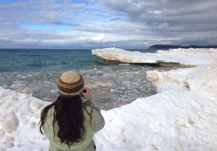
Laura getting the shot, photo by Andrew McFarlane

“A ship is safe in harbor, but that’s not what ships are for.”
~William G. T. Shedd

Every so often I have to write a post to clarify what Michigan in Pictures is or is not, and I guess that today is one of those days.

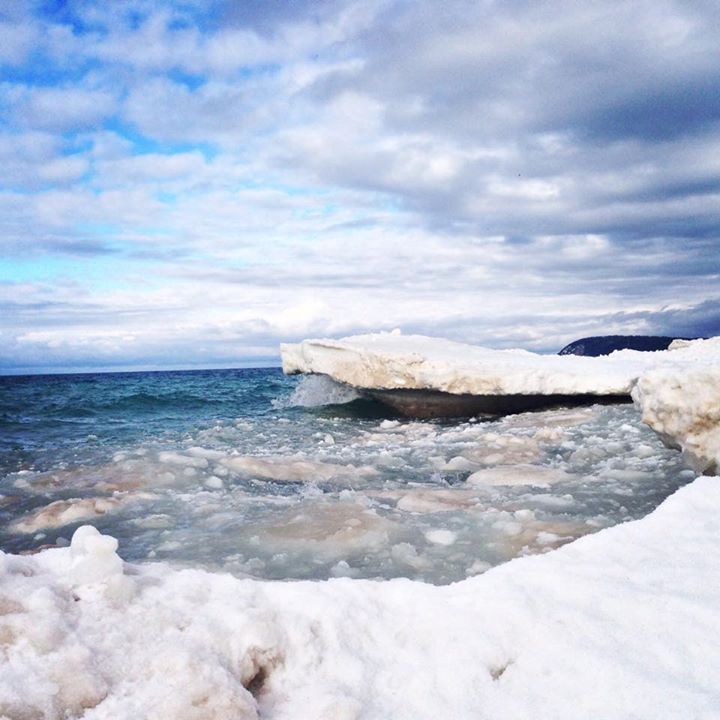
Sunday morning, I posted this photo (also at the bottom of this post) to the Michigan in Pictures Facebook page with the very accurate caption “We went out to Good Harbor Bay on Lake Michigan yesterday to play on the ice!” As you can see from the photo, Laura is positioned well back from the edge. While perhaps not perfectly safe, she is far safer than she was driving to the beach.

Several readers took issue with the idea that it’s appropriate to “play” in a potentially hazardous environment like shelf ice on Lake Michigan, suggesting that it’s irresponsible for me to share photos from risky environments, that I not do it, and that I focus on providing precautionary education encouraging people to make safe decisions. I replied (in part):

Shelf ice is indeed dangerous if you don’t know where you are and what you’re doing. The water where we were is 3′ deep in summer and the ice very solid, so in my opinion, play is exactly what it was.

Your concern for safety is good, but if you take proper precautions, you’re a heck of a lot safer here than driving on a winter road.

I post pictures all the time where the photographers have taken calculated risks to see, photograph and experience things that you cannot see and photograph without an element of risk. I allow my son to surf in conditions that can be very dangerous, let my daughter climb trees high enough to probably kill her if she fell, and hiked on trails where one slip meant death.

I suppose I should post disclaimers of “don’t be an idiot” with all photos of risky environments, but I think I will continue to assume that my readers will assess risks on their own, and I will continue to experience and share Michigan as I choose.

…Please understand that Michigan in Pictures is a place where I share amazing pictures that are shared with me. I’m not doing this as a public service to educate people on how to stay alive and safe. I do it for love of Michigan and to share the cool experiences it offers. I trust that my readers will exercise appropriate caution as they enjoy Michigan, and I’m 1000% sure that if folks get out and wisely play a little closer to the edge, they’ll have a happier and longer life.

Caveat emptor!

Caveat emptor will remain the policy of Michigan in Pictures, which I will again remind readers is my personal blog, not paid for by anyone and offered with the sole hope that you can find pictures and places that help you enjoy and appreciate Michigan more.

View my photo background big and see more on our mileelanau Instagram.

PS: Thanks to Kate Wittenberg for the perfect William G. T. Shedd quotation that she shared in the comments!

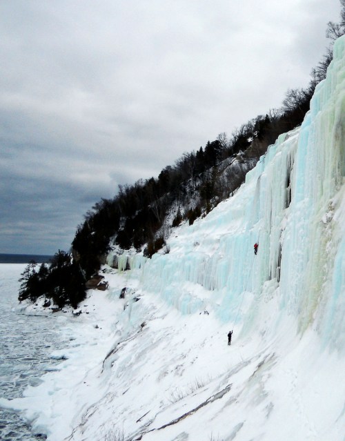
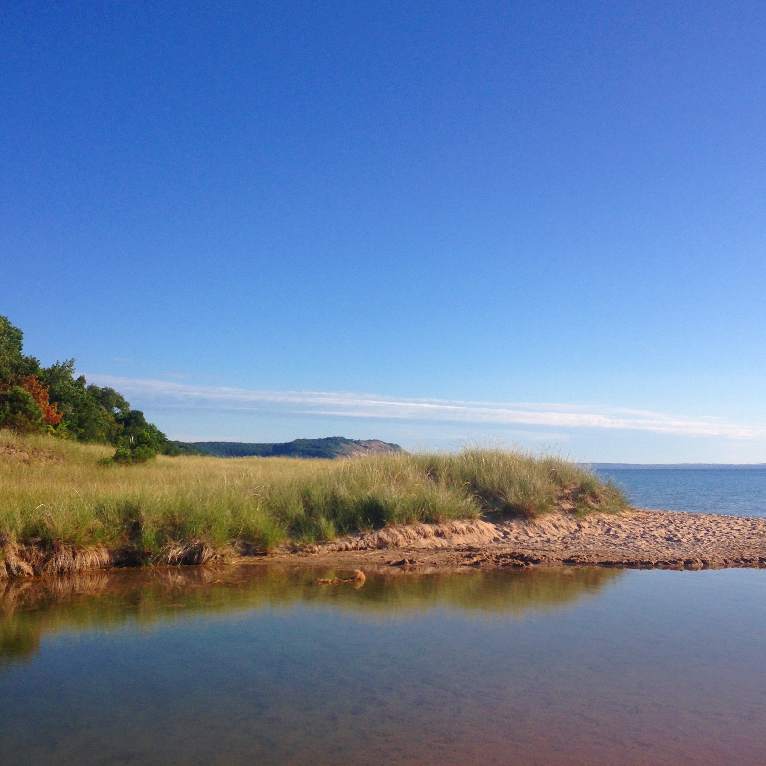
PPS: Here’s the photo Laura shot. Position, framing, tone.

Lauras Photo

Happy 178th Birthday to you, Michigan!

Michigan Sign at State Line 1958

Michigan Sign at State Line 1958, photo by Seeking Michigan

Today is Statehood Day, Michigan’s 178th birthday. For Michigan’s 175th birthday in 2012 I put together some fun facts about Michigan. They’re still true and still fun!

  • Michigan is derived from the Indian word Michigama, meaning great or large lake. (more about Michigan’s name on Michigan in Pictures)
  • French explorers Étienne Brulé & Grenoble are the first recorded Europeans to set foot in Michigan (you never know though). In 1668 Fathers Jacques Marquette and Claude Dablon established the first mission at Sault Ste. Marie, and in 1701, French officer Antoine de la Mothe Cadillac founded  Fort Pontchartrain in Detroit.
  • The Michigan Territory was created, with Detroit designated as the seat of government and William Hull appointed as our first governor.
  • Michigan became the 26th state on the 26th of January, 1837. Is 26 our lucky number? FYI, our first State governor was Stevens T. Mason, the 25 year old Boy Governor (the youngest state governor in American history).
  • Michigan’s nickname is “the Wolverine State”. It is generally believed to have been coined during the 1835 Toledo War between Michigan and Ohio, when our southern rivals gave us the name due to the wolverine’s reputation for sheer orneriness!
  • The Great Seal of Michigan was designed by Lewis Cass and was patterned after the seal of the Hudson Bay Fur Company. It depicts an elk on the left and a moose on the right supporting a shield that reads Tuebor (“I will protect”).The interior of the shield shows a figure on the shore with the sun rising over a lake. His right hand is raised, symbolizing peace, but he holds a rifle in his left hand, showing readiness to defend the state and nation.Below the shield is the inscription of our state motto Si quaeris peninsulam amoenam circumspice: “If you seek a pleasant peninsula, look about you.” (I just learned that Michigan has an Office of the Great Seal – how cool would it be to say you worked there??)
  • The original State Capitol of Michigan was Detroit, and it moved to Lansing in 1847 to help develop the western side of the state and due to the need to develop the western portions of the state and for easy defense from British troops. Here’s apic of Michigan’s original Capitol Building and an 1890s view of the current Michigan capitol.
  • Michigan is the 10th largest state by area if you count the water … and who wouldn’t count the water??
  • Speaking of water, we have 3,288 miles of Great Lakes shoreline, good for second to only Alaska in coastline!

View the photo background big and see more in their Tourism slideshow.

More of Michigan’s birthday on Michigan in Pictures.