Ice on the Straits of Mackinac

Ice in St Ignace

Last week in St. Ignace, photo by Thomas Nighswander

Doesn’t look like we’ll get an ice bridge for snowmobiles to Mackinac Island this winter.

Click to view the photo bigger and follow him on Facebook and at National Photography Workshops.

More ice on Michigan in Pictures.

#TBT: Marquette’s Chief Kawbawgam

Chief Kawbawgam

Chief Kawbawgam, photo via Michigan’s Past & Superior View Gallery

Michigan’s Past shares all kinds of great old photos on Twitter. This one shows Chief Kawbawgam, a Chippewa who was reportedly over 100 years old when he died in Marquette in 1903.  According to the January 1903 edition of the The Lake Superior Journal:

Charley Kaw-baw-gam’s long life was brought to a close about 2 o’clock Sunday afternoon, when the old chief passed peacefully away at St. Mary’s hospital at Marquette, where he had been lying ill for the past couple of months.

Charley was one of the best known figures in Marquette, and he enjoyed this distinction from the first day when white men began to frequent the spot where the city was to grow. Charley’s reputation was not local alone. He was known throughout the upper peninsula and even below the straits his name and fame were familiar to many people.

He was an excellent type of the original owners of the soil, and an unusually creditable specimen. He was a full blooded Chippewa and a chief by blood. What is more he was a good Indian, and he lived a good life, according to his lights.

Kaw-baw-gam was also remarked upon time and again for his great age. It is believed that he was over 100 years old at the time of his death.

In 1849 when Peter White first landed on the shores of Iron bay it is well known that the first Indian to greet him and the party of which he was a member was the same chieftain. In the same year 1849, Mr. White, in carrying on a conversation in Chippewa with Charley asked him, for the sake of having something to say, “How old are you, Bawgam?” Charley replying said: “I am fifty. I spent twenty at the Soo; twenty years on the Tonquomenon bay and ten years on the Canadian side.” If Charley spoke the truth on that occasion he was about 103 years of age when he died, and there was no reason to doubt that this was the case. The Indians of his day were a notoriously long lived race and Charley was a find Indian physically, strong, tireless and healthy. Furthermore his countenance was that of a patriarch.

You can see Chief Kawbawgam’s grave in Marquette’s Presque Isle Park.

View the photo bigger and definitely follow @MichiganHist on Twitter for lots more great photos.

More Throwback Thursdays and more portraits on Michigan in Pictures.

Waterfall Wednesday: Manido Falls in the Porcupine Mountains

Manido Falls Porcupine Mountains Wilderness

Manido Falls, Porcupine Mountains Wilderness, photo by Kirt E. Carter

The Waterfall Record’s page on Manido Falls has directions and some more photos and says:

Manido Falls did not impress me at first, at least not as much as the downstream Manabezho Falls. After seeing the pictures I had taken, though, I discovered what an amazingly beautiful waterfall Manido Falls is. It’s beauty comes from its complexity. The waterfall itself is not very tall at all. It is wide, though. As the Presque Isle River tumbles down toward Lake Superior, it comes to this set of rocks that create a beautifully cascading waterfall. I think what makes me like Manido Falls so much is that the water has taken such an interesting course here, erosion taking its effect in an oddly unique way.

Add to it that the just as spectacular Manabezho Falls is only hundreds of yards away, and Lake Superior not much more distant, this makes for one of the most beautiful waterfall stretches in the Upper Peninsula.

View Kirt’s photo bigger and check out his website for more.

More Michigan waterfalls on Michigan in Pictures!


Michigan Weird Science: The Menominee Crack

Birch Creek Michigan Crack in Forest

The Menominee Crack, photo courtesy Michigan Tech College of Engineering

Gizmodo reports that back in October of 2010 folks near Birch Creek in Menominee County heard a boom, felt the earth rock, and woke up to find a 360′ crack in the ground:

The first clue was the fact that the split happened at the top of a ridge. A pop-up isn’t a wrenching apart of some deep underground structure. It’s a large piece of ground suddenly pushing upwards, so that the ground above splits over it. The researchers discovered the pop-up by the sophisticated technique of slamming a sledgehammer against a metal ball sitting on the ground. The action caused sound waves to move through the rock beneath—and depending on the formation of the rock, the sound moves at different speeds. In this case, it moved in hugely different ways parallel to the crack, as compared to perpendicular to the crack. This indicated that there was a huge fracture in the limestone underneath the crack.

These sudden fractures occur due to extreme strain in the rock—strain that can be pent up for centuries. It’s more common around quarries, when removal of large pieces of rock can cause the rest to suddenly fracture and pop upwards. Other times, it can occur spontaneously. The Menominee Crack, as its now called, was probably the result of a spontaneous fracture—although the researchers speculate it might have happened due to the removal of a large tree from the area.

Read more at Gizmodo and check Michigan Tech for a detailed explanation of the Menominee Crack and Live Science for more photos. If you want to creep yourself out a little more, check out the probably related Wisconsin mystery booms!

Thanks Michigan Tech’s Engineering College for the photos and for all you do to help unravel the mysteries of Michigan!

If you like stuff like this, there’s plenty more Michigan weirdness on Michigan in Pictures!

February at the Eben Ice Caves

Eben Ice Cave Entry

Ice Cave Entry, photo by Eric Hackney

On the Pure Michigan blog, guest blogger Jesse Land of Things To Do in the U.P. details how to get to the Eben Ice Caves in Michigan’s Upper Peninsula, writing in part:

Just outside of Marquette County, the Eben Ice Caves are one of Michigan’s prime winter attractions. Each winter, once the ice caves start to freeze up (usually sometime in December), visitor’s flock to the tiny town of Eben Junction to see the ice caves and, while they’re out there, support local businesses like the Eben Ice Caves concession stand, the Rock River Cafe and the New Moon Tavern.

The “Rock River Canyon Ice Caves” better known as the Eben Ice Caves, form when melting snow runs over the edge of a small cliff and freezes, forming “ice caves” Much like the large ice formations along Munising’s Grand Island and parts of Pictured Rocks National Lakeshore, if you were to visit here in the summer you would see little to no water running over the edge.

Sometimes I feel like Eric spends his time at all the cool Michigan places I never seem to make it to. View his photo bigger and see more in his 2-5-16: Eben Ice Caves II slideshow. Readers who are on the ball will wonder about #1 in the series – here’s 1-31-15: Eben Ice Caves that also includes pics of Munising Falls, MNA Memorial Falls and Tannery Falls!

Read more about the Eben Ice Caves in this Michigan in Pictures post featuring Nina of Black Coffee at Sunrise.

Baltimore River Ice Curtains

Ice Curtains on the Baltimore River

Baltimore River Ice Curtains, photo by Eric Hackney

Eric took this photo on the Baltimore River, just upriver from O Kun De Kun Falls. Although it takes place about 6 miles away in Munising, this is a good opportunity to remind you about the upcoming Michigan Ice Fest (Feb 10-14, 2016). Climbers & climbing enthusiasts from around the world converge to climb, socialize and learn about this winter sport. There’s plenty of fun for newbies too including guided climbs!

View his photo bigger, check out more in his Ontanogon County Adventures III slideshow, and follow Eric Hackney Photography on Facebook.

More about O Kun De Kun Falls on Michigan in Pictures.

January 20, 1985: The Michigan Moose Lift

Upper Peninsula of Michigan moose

Upper Peninsula of Michigan moose, photo by Greg Kretovic

Every so often, something I have featured on Michigan in Pictures will vanish from the internet, leaving whatever I shared as the only remaining source. Such is the case with one of my favorite modern Michigan stories, The Michigan Moose Lift of January 20, 1985. Click that link to read about this historic operation that relocated 59 moose from the Algonquin Provincial Park in Ontario and led to the re-establishment of moose in Michigan’s Upper Peninsula – somewhere north of 400 at last estimate*.

Here’s a very cool video from the DNR that does a great job of telling the story. Enjoy!

Greg took this photo of a large bull moose exploring the shoreline of an inland lake in Baraga County in October of 2012. View his photo bigger, see more in his slideshow, and definitely follow him at Michigan Nature Photos on Facebook.

* From the Detroit Free Press article on the latest biennial survey of Michigan’s moose population:

The latest biennial survey by the Department of Natural Resources produced an estimate of 323 moose in their primary Michigan range, which includes Baraga, Iron and Marquette counties. If correct, that would be a decline there of about 28 percent from 2013, when the estimate was 451.

Chad Stewart, a deer, elk and moose management specialist with the DNR, said the population could have held steady since the 2013 count but that the findings, including a decrease in the number of calves spotted with adult females, suggest a decline is the likelier scenario.

It is “quite possible that we’re looking at a considerable drop in numbers,” Stewart said Monday.

A smaller moose herd wanders the eastern U.P. Biologists have long estimated their number at around 100.

Winter at Bond Falls

Winter at Bond Falls

Winter at Bond Falls, photo by Aime Lucas Photography

The Bond Falls entry at GoWaterfalling.com says:

Bond Falls is in the western U.P. on Bond Falls Rd, east of Pauding MI. This is the most impressive waterfall in Michigan with the possible exception of Tahquamenon Falls. The main drop is 40 feet high and 100+ feet wide. Above the main falls are a series of cascades and rapids that must drop a total of 20 feet.

The water level is controlled by a dam, and a steady flow over the falls is maintained for scenic reasons. Of course during the spring melt the flow is much higher.

Bond Fall is a Michigan State Scenic Site. The site was renovated around 2003. The old parking area was upstream of the falls, and a steep concrete stairway led to the base of the falls. The new parking area is near the base of the falls, and a level boardwalk leads you to prime views of the falls.

Read on for more including directions to the falls.

Aime writes: The majestic Bond Falls. Normally a short, easy walk but in the winter a very hazardous one. The steep steps were covered with a few layers of ice and the path was extremely slippery. It was totally worth it.

View her photo bigger, follow her on Facebook, and purchase prints and see more work on her website!

Many more Michigan waterfalls on Michigan in Pictures.

Support Michigan in Pictures with Patreon

Ice is Nice at the Menominee Light Lighthouse

Ice is Nice Menominee Light Lighthouse

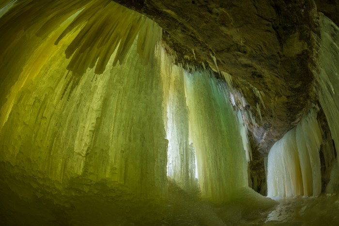
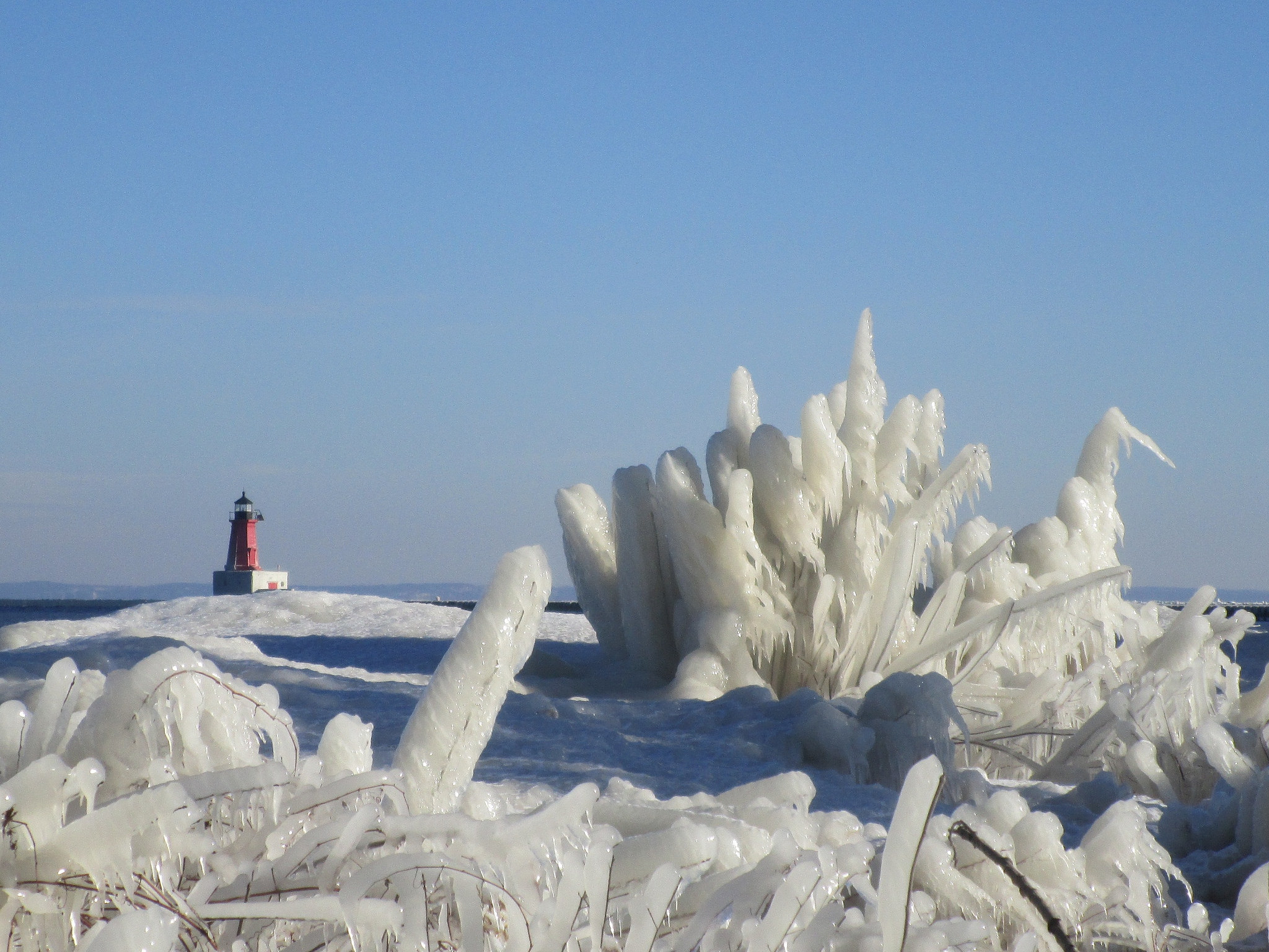
Ice is Nice, photo by cohodas208c

I’ll never miss a chance to tout Terry Pepper’s Seeing the Light as one of the premier resources for information about Michigan’s lighthouses, as well as others on the Great Lakes. He packs them full of the history including the political maneuverings and economic reasons for lighthouse development and closure and peppers in (sorry – couldn’t resist) historical photos and pictures from his own visits.

The entry on the Menominee North Pier Light details the lumber boom that led to the construction of the first lighthouse in 1877 and the development of the iron ore rich Menominee Range. He continues:

The town of Menominee continued to reap the benefits of the Range, and as a result significant harbor improvements were undertaken in the 1920’s, At their completion in 1927, a prefabricated octagonal cast iron tower was delivered by vessel, and lowered onto the pier.

The thirty-four foot tower was painted white, and integrated with an attached fog signal building. An elevated wooden catwalk stretched along the wooden pier to provide the keepers with safe access to the light during periods when waves crashed across the surface of the pier. The octagonal cast iron lantern room was outfitted with a Fourth Order Fresnel lens of unknown manufacture.

At some point thereafter, the wooden pier was replaced by a concrete structure with a forty-foot diameter circular crib at its offshore end. At this time, the fog signal was eliminated with the inclusion of an automated electrically operated signal in the tower. With automation of the light in 1972, the need for daily maintenance of the light was also eliminated, and the iron catwalk was removed from the pier.

The tower was painted bright red, and relocated to a white painted concrete platform in the center of the crib. Its elevated position on the pier provided a focal plane of forty-six feet.

While the catwalk no longer snakes its way along the pier, the iron tower still stands guard over the harbor entrance, its jewel-like Fresnel lens replaced by a stark modern 300mm plastic lens.

Read on for more at Seeing the Light.

View the photo background bigilicious and see more in cohodas208c’s Big City Breakout – Dec 2015 slideshow.

Lots more Michigan lighthouses and more winter wallpaper on Michigan in Pictures!

#TBT: Rephotographing Michigan, Baraga Edition

Downtown Baraga Michigan

Downtown Baraga, photo by Rephotographing Michigan

Paul started Rephotographing Michigan a few months ago. It’s a project to take old postcards of Michigan and photograph what the scene looks like today.

This photo shows downtown Baraga – check it out bigger and see lots more on the Rephotographing Michigan Facebook page!