Reflections :: Saugatuck, Michigan

Reflections

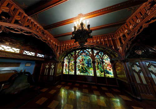
Reflections, photo by chatursunil.

We get about 100 people a day who are searching for backgrounds for their computer. To them I say: this photo makes a great background!

Saugatuck (pop. 1065 in 2000) is the sister city to Douglas. This Saugatuck/Douglas history page says that unlike most Midwest frontier towns, neither town suffered the devastating fires nor the modernizing railroad. As a result, the villages provide a rare chance to see pre- and post-Civil Ware Greek Revival and Italianate architecture alongside later structures in the Arts & Crafts and Colonial Revival manner.

Like Douglas and many communities along Michigan’s western shore, Saugatuck was timbered out after the Great Chicago Fire of 1871. Still…

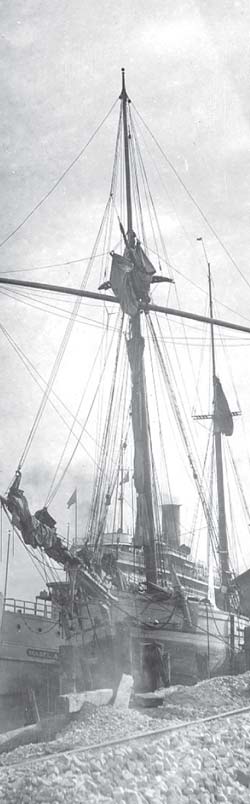
…Saugatuck and Douglas thrived, turning to shipping and fruit growing as a source of income in the latter part of the 1800s. Peaches from the area were called “Michigan Gold” and were shipped by large steamships to the Chicago market. Hundreds of ships of various types were built in Saugatuck shipyards and the town was a haven for ship captains.

A resort, tourist, and “cottage” culture emerged in the 1880s and took a propitious turn in 1910 when a group of Chicago artists established the Summer School of Paintings on Ox-Bow Lagoon, and when a huge dance hall, called the Big Pavilion, was built on the waterfront. The resulting influx of well-known artists and big name Chicago architects resulted in a wave of building in the Arts & Crafts and Colonial Revival manner. The seed planted at Ox-Bow has continued to flourish over the years, with the area is now known as the Art Coast of Michigan. Today, Ox-Bow continues to be affiliated with the Art Institute of Chicago.

The Saugatuck/Douglas Visitors Bureau has a huge pile of information and photos and links, including a link to a pretty informative video tour of Saugatuck/Douglas. There’s also the Saugatuck/Douglas Area Business Association with more events, news & listings. Wikipedia’s entry on Saugatuck says that attractions today include art galleries, the harbor, marinas, scenery, unusual stores, the view from atop Mount Baldhead, tourist attractions, the famous Oval Beach on Lake Michigan, Saugatuck Dunes State Park and Allegan State Game Area.

Cool new feature alert!

Here’s the Google Map for Saugatuck in our newly created Absolute Michigan map of Michigan. I’ll try and loop back and add maps for the other entries in our Michigan shoreline tour.

Modern Day Detroit … from above

modern day Detroit

modern day Detroit, photo by paulhitz.

Paul says that this photo of Comerica Park and the Detroit skyline was shot Sunday from a helicopter tour around Detroit during the Detroit International River Days Festival (held late June every year). I was going to ask Paul how the heck he managed a helicopter ride, but apparently helicopter rides from Walton Helicopter Charter were part of River Days this year.

Paul encourages you to view this picture bigger (yes, it makes a great computer background). You can also view more helicopter-eye photos of Detroit.

The Shiawassee River

Shiawassee River

Shiawassee River, photo by naokomc.

Poked around the map of Michigan this morning, looking for a place I hadn’t been. That turned out to be the Shiawassee River. (Shiawassee River slideshow)

The very good (if staggeringly bright yellow) page on the Shiawassee River basin from Shiawassee History says:

The Shiawassee River Basin plays a major role in the mid-Michigan area. Its drainage area is approximately 1,200 square miles and portions of the river touch at least 7 counties.

The river is about 110 miles long and generally flows in a northerly direction, which is one of only two or three in the world. The Flint River, Cass River and Titabawassee River join the Shiawassee just southwest of the City of Saginaw and together form the Saginaw River which drains into the Saginaw Bay.

Shiawassee History also explains that Shiawassee may come from the Chippewa term for straight running river; Shiawassee (straight, or straight ahead) wassee. Then again, you can find other sources saying that the name means “river that twists about”.

The Nature Conservancy has a nice page on the Shiawassee River Watershed and the threats it faces from development pressures.

I’ll link to Wikipedia’s brief entry on the Shiawassee River because it had a link to Headwater Trails proposed Shiawassee River Water Heritage Trail (and in hopes that someone can go there and make the entry better).

Update (6/12/07): I just found the Saginaw Basin Land Conservancy who relate that the Saginaw Bay Watershed is the largest contiguous freshwater coastal wetlands system in the United States, featuring more than 175 inland lakes and about 7,000 miles of rivers and streams that are home to large populations of waterfowl, birds, snakes, turtles, amphibians, and more than 138 endangered or threatened species. They’re having a photo contest too – see the comments for details!

Celebrating 360 degrees of Michigan Week at the Dossin Great Lakes Museum

Gothic Room from the SS City of Detroit III

Gothic Room from the SS City of Detroit III, photo by Mark Houston

In celebration of Michigan Week (May 19 – 25, 2007), Mark Houston over at 360Michigan has posted new panoramas from four locations: the National Trout Memorial (downtown Kalkaska in front of the Kalkaska Historical Museum), the Michigan Fireman’s Memorial (near Roscommon), the Manistee River and the Dossin Great Lakes Museum (Belle Isle, Detroit).

All of these are available as full screen, 360˚ QuickTime VR panoramas and are well worth a look, but the ones of the Dossin Museum really showcase the power of the technology.

The 16,000 square foot Dossin Great Lakes Museum is located on Belle Isle in the Detroit River and is dedicated to showcasing the story of the Great Lakes and Detroit’s role in regional and national maritime history. Permanent exhibits at the museum include the Miss Pepsi hydroplane racing boat, the bow anchor of the Edmund Fitzgerald, the S.S. William Clay Ford Pilot House, the restored smoking lounge of the S.S. City of Detroit III and one of the largest known collection of scale model ships in the world.

Mark has also created a Google map showing the location of all his panoramas.

An Afternoon at Flat River

Frog at Flat River State Game Area

David McGowan is a travel photographer working out of West Michigan. Of the day he took this photo, he writes:

Today (May 2, 2007) seemed the perfect day to tour our public wetlands. It’s that sweet part of Spring with lots of budding and blooming, yet not so overgrown that you can’t freely move along a creek or river. This series is from the Flat River and a couple of its tributaries, which I’m sure I wouldn’t have mentioned had I found any morel mushrooms.

Click over to David’s site, humanfiles, to view more photos from his afternoon at Flat River and galleries with many more shots from Michigan (and elsewhere, but I’m not sure I can talk about photos from elsewhere).

You can get more info about the Flat River State Game Area from the DNR and also get the scoop on paddling Flat River from Michigan Water Trails.

Holland, by rail and sail

Interurban electric railroad on the Holland and Lake Michigan Railway

Mabe Bradshaw, the first passenger ship

On July 4, 1898, the first Interurban electric railroad car to carry passengers arrived in Holland. The first rails in Holland had been laid by the Holland and Lake Michigan Railway at River (Avenue) and Eighth Street. These cars are on the track a half-block east of there. More than 100 men and 17 teams of horses constructed the line. The payroll for construction workers was $1,000 weekly. The trains ran from Grand Rapids through Grandville, Jenison, Shack Huddle, Jamestown, Forest Grove, Vriesland, Zeeland, Holland, Jenison Park, Macatawa Park, and Saugatuck. The Interurban freight office was on Eighth Street near Pine Avenue. The passenger train continued south on River and turned west on 13th Street. The line continued near South Shore Drive, stopping near Sunnybrook Station at Virginia Park. Extending south near 160th Street, the train headed to Castle Park and Saugatuck. The train met its demise November 15, 1926.

The first time a passenger ship connected Holland directly with Chicago, via Lake Michigan, was July 4, 1889, when the Mabel Bradshaw docked at the foot of Fifth Street at the old Harrington Dock. That first year the ship made four trips a week, leaving Holland on Sunday, Monday, Wednesday, and Friday evenings, after the arrival of trains at 6:35 p.m. The fare was $2 one way or $3.50 round trip. Owner Hugh Bradshaw named the ship after his daughter Mabel. She was to christen the ship with a bottle of champagne. As she reached for the bow, the bottle slipped from her hand and fell into the water, leaving the ship unchristened. The ship was used for a ferrying service a few years later and spent its last years on Lake Superior.

Be sure to click the photos for a larger view!!

Photos reprinted with permission from Holland: The Tulip Town by Randall P. Vande Water. Available from the publisher online at www.arcadiapublishing.com or by calling 888-313-2665.

View other excerpts from Arcadia Publishing’s Michigan books at Michigan in Pictures!

Connecting the dots on the Grand Rapids skyline

Grand Rapids skyline

Grand Rapids skyline, photo by sparky05.

Web technology like tagging and social networks are increasing our ability to relate our photos to real world data and to relate to each other through our photos.

A great example of this can be found in the ways in which photos of Grand Rapids are woven together. Using Flickr, you can assign locations to your photos. Here’s a photo map of downtown Grand Rapids featurign pictures taken by Sparky and others.

Maps aren’t the only way to connect with photographers (and photographs) of Grand Rapids. Check out the Grand Rapids, Michigan Group on Flickr. Two other good spots are the Grand Rapids Photo Blog and the Grand Rapids forum on UrbanPlanet.org.

Building buffs will also want to head over to the Skyscraper Page for buildings of Grand Rapids. It gives details of all the buildings (including those under construction), drawings of the individual buildings and a lineup of Grand Rapids buildings by height.

All of this may seem like overkill, but consider how incredibly useful this might be to a company that was scouting Grand Rapids (or your city) as a potential location.

Waterfall Hunting in the Upper Peninsula

Ripley Falls

Ripley Falls, photo by We Are CS.

It’s probably fitting that I came to today’s post in a roundabout fashion. I was checking out UPLiving.com, a new addition to Absolute Michigan. On their photo page I saw this gorgeous photo of Ripley Falls. A quick check of The Google found a page on the Hiawatha National Forest site that itself seemed lost from their waterfalls page titled
115 Waterfalls of Michigan’s U.P.:

It’s been said there are two things man never tires of watching – fire and falling water. Hence the fascination of fireplaces and waterfalls. Fireplaces, fortunately, are found everywhere in the land. But waterfalls are found only in very special parts of the land. One of these is Michigan’s Upper Peninsula. There are more than 150 waterfalls across the length and breadth of this rugged peninsula – enough to satisfy any collector of cascades. Some are tall and stately like the Laughing Whitefish. Some are broad and massive like the mighty Tahquamenon. All are spectacles of white splendor … A few of the Upper Peninsula’s falls are located conveniently along well-traveled highways. More often the falls are the dramatic climax to a rewarding hike through the woods and in every case they are well worth the effort involved in getting there. Some waterfalls are located on private property permission should be secured from the owner to cross the property. When large land holders such as paper, utility, mining, and forest companies are involved, the public is usually welcome to use the forest lands, unless posted against entry.

Ripley Falls was listed as #42 with just the terse note Ripley Falls, on Ripley Creek behind school of Ripley. Springtime flow only.. The Keweenaw Local Resource Guide has better directions, but still not much to say.

Then I stumbled onto Wayne Premo’s Waterfalls from Hunt’s Guide to Michigan’s Upper Peninsula. Wayne tells the tale of how he lost the Michigamme Falls and then says:

As an adult I started to explore the Upper Peninsula further. The state’s Department of Natural Resources county maps became my guide. All the squiggles marking falls became increasingly intriguing. Would any of these be as impressive as Michigamme Falls, the one I had lost? I charted my plan of attack.

My goal was to search out every squiggle and photograph it, so that then I would have seen every waterfall of consequence in the Upper Peninsula. At the time, I was in no hurry and the task did not appear formidable.

Michigan WaterfallsSo go to Hunt’s Guide and read Wayne’s tale and check out some of the waterfalls he has photographed. Then think about bagging a few waterfalls this year. You can click the photo to the right to go on a Flickr tour of Michigan waterfalls.

And after all this, what does Wayne say about Ripley Falls? Only that it’s one of the few falls not on the DNR maps.

Fitting.

Kayak on the Pine River Channel

Kayaking through the Channel

Kayaking through the Channel, photo by smiles7.

The lighthouse is the Charlevoix South Pier Light, and it marks the mouth of the Pine River channel that extends from Lake Charlevoix to Lake Michigan. Terry Pepper’s Seeing the Light explains:

The Pine River Channel is believed to be unique in the entire world inasmuch as it has a two-way current. After severe westerly windstorms, waters pushed high into Lake Charlevoix will swiftly flow back out to meet other inbound currents. Small whirlpools and eddies at the harbor mouth are not uncommon, and whitecaps can frequently be observed within the channel on the calmest days.

You can get a lot more information about the history of Charlevoix’s Pier Lights from Terry Pepper and see historical photos including a cool postcard of the Charlevoix North Pier Light in 1909. If you want to visit Charlevoix, the Charlevoix Area Convention and Visitors Bureau is a good place to start.

Renaissance

Renaissance, photo by irinuchka.

…in the Renaissance Center, Detroit.

Kind of amazing what can be accomplished when you try to accomplish something amazing. More at Detroit Marriott at the Renaissance Center from SkyscraperPage.com, Renaissance Center from Wikipedia and Flickr’s RenCen slideshow.