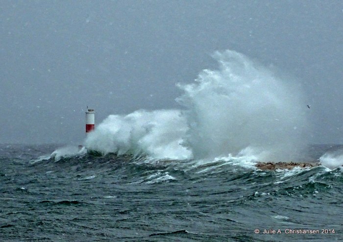
Julie got a great shot of the waves rolling over the pier at Petoskey. View it bigger and see more in her giant-sized Michigan slideshow.
PS: Julie shared this in the Michigan Cover Photos group on Flickr, and it’s the latest cover photo on the Michigan in Pictures Facebook. Please feel free to share yours there too. If you’re a Facebooking person, you might want to become a fan of the page for bonus weekend photos and discussion about the photos featured here!
Michigan State University, the University of Michigan and Wayne State University, the three universities that make up Michigan’s University Research Corridor (URC), have released a report titled “Innovating for the Blue Economy“. The report cites nearly $300 million in awards for water-related research and outreach from 2009 to 2013 that have led to innovations from dealing with invasive species and monitoring water quality to finding ways to optimize water use in agriculture. Their news release on the report prepared by the Anderson Economic Group (AEG) says in part:
AEG’s analysis showed that Michigan ranked fourth in the nation in the percentage of jobs associated with industries related to water, at 718,700.
“One in five Michigan jobs is tied to having good and plentiful water,” said AEG founder and CEO Patrick Anderson. “It is an important economic driver in Michigan, and extends to Great Lakes shipping, advanced manufacturing, agriculture and fishing, and over 80 other industry subsectors where Michigan workers are employed today.”
While most of Michigan’s water-related jobs are in water-enabled industries such as agriculture, mining and manufacturing, about 138,000 are in core water products and services producing water treatment facilities and solving water quality and quantity issues.
“Water isn’t just Michigan’s defining characteristic but the foundation of life on earth,” said Michigan State University President Lou Anna K. Simon. “Our three universities make significant commitments to support water-related research and programs. These not only support Michigan’s economy and quality of life, but position the state as a knowledge wellspring for the world’s most precious natural resource.”
Read on and read the full report right here. The report is chock full of interesting facts including that those 718,700 jobs represent 21.3% of Michigan’s total employment (4th in the nation) and details many of the accomplishments of Michigan’s investment in our “Big Three” university research programs. Also note that “downstream” industries like tourism that rely on healthy water resources aren’t included in the numbers.
Robby writes that Otter Creek Beach has to be the reason why Sleeping Bear Dunes was Voted “Most Beautiful Place in America” by Good Morning America. View his photo bigger and see more in his slideshow.
Petoskey State Park, located on the north end of Little Traverse Bay, is situated on 303 scenic acres and offers a beautiful sandy beach on the bay. The park has two separate modern campgrounds. Tannery Creek offers 98 campsites, and Dunes offers 70 campsites.
The park land was originally deeded to Pay-Me-Gwau under an Ottawa Indian treaty in July of 1855. Later, much of the land was the site of the W.W. Rice Company. In 1934, the City of Petoskey purchased the land and named it the Petoskey Bathing Beach. In April of 1968, the beach was sold to the State of Michigan. On May 21, 1969, the state was given the title to the land. The campground opened its sites to the first campers in July of 1970.
Almost a century after the founding of Petoskey, on June 28, 1965, Governor George Romney signed a bill that made the Petoskey Stone Michigan’s official State Stone. It was fitting that Miss Ella Jane Petoskey, the only living grand-child of Chief Petosegay, was present at the formal signing. The legislation is very general. The bill simply states that the Petoskey Stone is the State Stone. The designation of Hexagonariapercarinata was made by Dr. Edwin C. Stumm in 1969. Dr. Stumm made this distinction based on his extensive knowledge of fossils.
This specific fossil coral is found only in the rock strata known as the Alpena Limestone. The Alpena Limestone is part of the Traverse Group of Devonian age. The Alpena Limestone is a mixture of limestones and shales. The outcrops of these rocks are restricted to the Little Traverse Bay area near Petoskey.
“No lake master can recall in all his experience a storm of such unprecedented violence with such rapid changes in the direction of the wind and its gusts of such fearful speed! Storms ordinarily of that velocity do not last over four or five hours, but this storm raged for sixteen hours continuously at an average velocity of sixty miles per hour, with frequent spurts of seventy and over.
Obviously, with a wind of such long duration, the seas that were made were such that the lakes are not ordinarily acquainted with. The testimony of masters is that the waves were at least 35 feet high and followed each other in quick succession, three waves ordinarily coming one right after the other.
~Report from the Lake Carriers Association in the wake of the Great Lakes “White Hurricane”
97 years ago the Great Lakes region reeled under the deadliest storm in its history. Known as the “Big Blow” and the “Freshwater Fury”, was a blizzard with hurricane-force winds that devastated the Great Lakes Basin in the Midwestern United States and the Canadian province of Ontario from November 7 through November 10, 1913. Read on for more!
Dear wife and Children. We were left up here in Lake Michigan by McKinnon, captain James H. Martin tug, at anchor. He went away and never said goodbye or anything to us. Lost one man yesterday. We have been out in storm forty hours. Goodbye dear ones, I might see you in Heaven. Pray for me. / Chris K. / P.S. I felt so bad I had another man write for me. Goodbye forever.
~A message found in a bottle 11 days after Plymouth disappeared, dictated by Chris Keenan, federal marshal in charge of the barge.
Wikipedia says that the Great Lakes Storm of 1913, also known as the “Freshwater Fury“or the “White Hurricane”, was a blizzard with hurricane-force winds that ravaged the Great Lakes November 7-10, 1913. With the sinking of 19 ships, the stranding of another 19 and a death toll of at least 250, it remains the deadliest and most destructive natural disaster in Great Lakes history.
Major shipwrecks occurred on all but Lake Ontario, with most happening on southern and western Lake Huron. Lake masters recounted that waves reached at least 35 feet (11 m) in height. Being shorter in length than waves ordinarily formed by gales, they occurred in rapid succession, with three waves frequently striking in succession. Masters also stated that the wind often blew in directions opposite to the waves below. This was the result of the storm’s cyclonic motion*, a phenomenon rarely seen on the Great Lakes.
In the late afternoon of November 10, an unknown vessel was spotted floating upside-down in about 60 feet (18 m) of water on the eastern coast of Michigan, within sight of Huronia Beach and the mouth of the St. Clair River. Determining the identity of this “mystery ship” became of regional interest, resulting in daily front-page newspaper articles. The ship eventually sank, and it was not until early Saturday morning, November 15, that it was finally identified as the Charles S. Price. The front page of that day’s Port Huron Times-Herald extra edition read, “BOAT IS PRICE” DIVER IS BAKER “SECRET KNOWN”. Milton Smith, the assistant engineer who decided at the last moment not to join his crew on premonition of disaster, aided in identifying any bodies that were found.
July 17th is Throw in a Petoskey Stone Day. If you’re unfamiliar with it, that’s because it was invented on Michigan in Pictures last July 17th. The basic goal is to preserve Petoskey stones for future generations by throwing them out into the water., but nobody can fault you if you decide to take one or more home with you.
Click that link above for more about Michigan’s State Stone. Here’s what Rose Petoskey has to say:
Many people would associate the word Petoskey with the souvenir stone found on the northern Lake Michigan shorelines. However, to my family, the word Petoskey represents much more than a souvenir.
In the Odawa language, the word Petoskey (Bii-daa-si-ga) means the rising sun, the day’s first light, or the sun’s first rays moving across the water. The Petoskey stone is a fossilized coral created by impressions made in limestone during the last Michigan ice age. These stones were named “Petoskey” because the impressions resembled the rising sun coming up over the water. Just as the image of the rising sun is implanted within the Petoskey stone, the archaeology of a person’s names is implanted within. All names within our Anishinaabek culture reflect an individual’s personal history. Rocks go deep, but names go much deeper to reveal the stories of the past.
As Dominique points out, you only get 4 points for L-A-K-E. When all is said and done, however, there are few words that are more important to Michiganders. The DNR notes that Michigan boasts more than 11,000 inland lakes and you can access 2,700 inland lake maps online.
The crucifix is made of white marble from Italy, and was a special order for a family in Rapson, Mich., as a memorial for a son killed in an accident on the farm.
After the structure arrived, it was discovered there had been damage to it. The family sold it as an insurance sale to a southern Michigan diving club, who wanted to place it as a memorial for their friend who died diving at Torch Lake. (ed. Charles Raymond)
The crucifix made its way to Little Traverse Bay, and was first placed by the U.S. Icebreaker Sundew 1,200 feet off the Petoskey breakwall on Aug. 12, 1962.
About 20 years later, the Michigan Skindiving Council tried to salvage what they could of the structure. It was lifted from the water, a new base was built in the Petoskey marina over the course of a day, and it was replaced in the bay.
At the time, Jessick was president of the council, and he proposed a winter viewing. The first was in 1986, affording the community the opportunity to view the statue through a hole made in the ice.
Jessick is Harbor Springs resident Dennis Jessick who helps organize the event. Sorry that I didn’t know about this in advance – I’ll try to keep an eye out next year but it doesn’t sound from the article like there’s a lot of lead time! There’s a little more in this Roadside America article about the Skin Divers Church.