Mark writes that there was a somewhat rare occurrence on the Northwestern shore of Michigan’s lower peninsula – the sun actually came out!
Check it out bigger in his slideshow and have a wonderful winter weekend!
PS: Speaking of ice, there’s the Zehnders Snowfest 2011 this weekend in Frankenmuth. It’s celebrating its 20th anniversary as one of the nation’s top snow sculpting events.
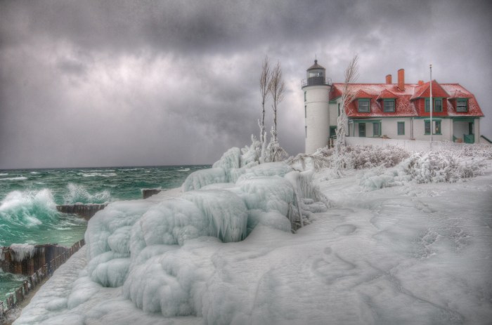
The plan for the Point Betsey Light called for a cylindrical single-walled tower constructed of Cream City brick, standing 37 feet in height from the foundation to the top of the ventilator ball. Five concentric brick rings encircling the tower beneath the lantern, each successively larger in diameter than the lower ring, formed a support for the gallery on which an decagonal cast iron lantern was installed. The lantern was outfitted with a white Fourth Order Fresnel lens equipped with bulls eyes, which was rotated around the lamp by a clockwork drive at a precisely monitored speed to impart the station’s characteristic fixed white light with a flash every 90 seconds. By virtue of the tower’s location on the dune, the lens was located at a focal plane of 52 feet above lake level with a range of visibility of ten miles. The small two story dwelling, also of Cream City brick was located on an excavated cellar immediately inshore of the tower, to which it was connected by a short covered passageway. This passageway was outfitted with a cast iron door at the tower end in order to stop the spread of any possible fire between the two structures.
The exact date on which the Point Betsey Light was exhibited has been lost to history. While Lighthouse Board annual reports and Light Lists report the station as being completed in 1858, it was not until February 1, 1859 that David Flury, the first keeper to be assigned to the station, appears in District payroll. Thus, it may well be that while construction was completed in 1858, the Light was not activated until the opening of the 1859 navigation season.
Read on to learn much more about this gorgeous lighthouse including the steps they had to take to unsure that the pounding surf you see here didn’t destroy the light.
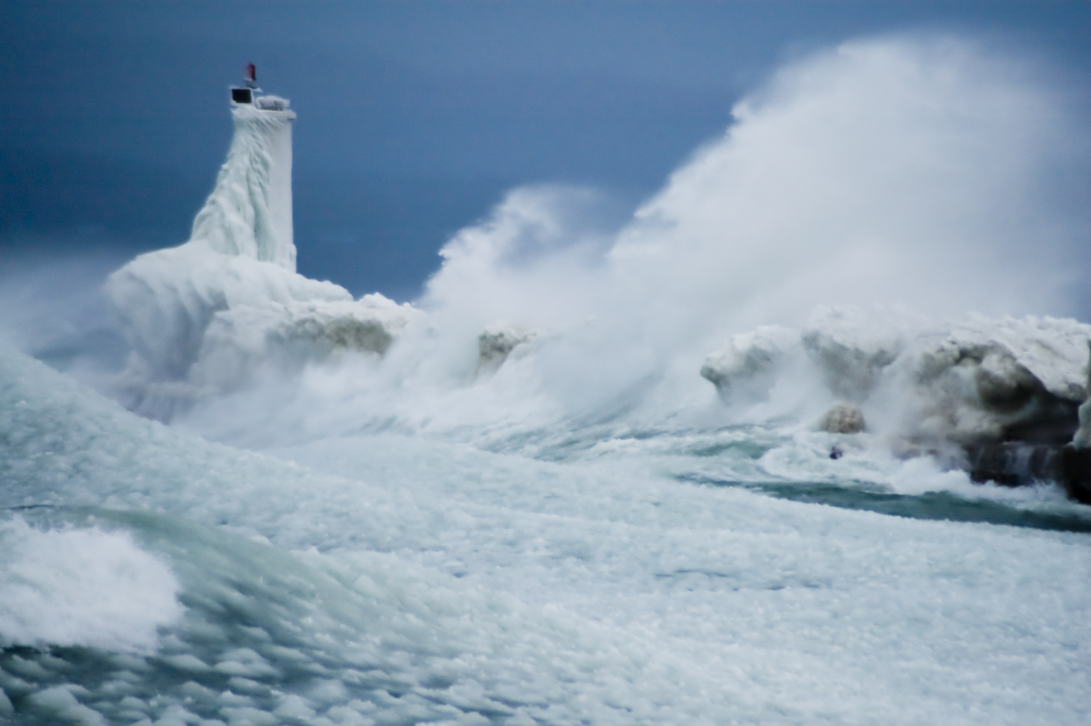
Check it out bigger in Jason’s Ice slideshow. And don’t miss this shot Jason took of Point Betsie’s neighbor, the Frankfort Pier Light being BLASTED by the big storm of October 2010!
Our January Event Calendar is posted on Absolute Michigan. Check it out for all kinds of January fun!
Shane took this photo as the sun was setting and the winds were whipping along at 40 MPH at the end of the first day of the 2011 in Ludington. Check it out bigger in his Michigan slideshow.
As we know, my laziness knows no bounds, so here’s the story behind “the Bear” on the Sleeping Bear Dunes that I wrote for Leelanau.com this morning!
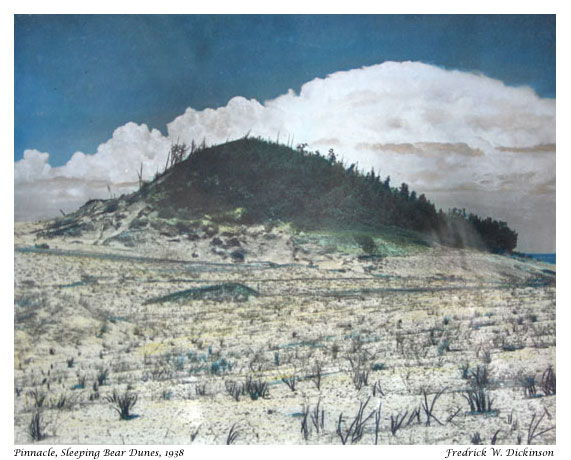
The other day we posted the Legend of the Sleeping Bear to Leelanau.com. After thinking about it, I wondered if folks knew that “the Bear” was also an actual formation atop a dune about a mile north of the Pierce Stocking Overlook. The Sleeping Bear Dunes National Lakeshore says that the formation pictured above known as “the Bear”…
…hardly looks like a bear now, for it has been changing rapidly in recent years. At the turn of the century, it was a round knob completely covered with trees and shrubs. You can still see some of the thick vegetation that gave it a dark shaggy appearance.
…For a long time, the sleeping Bear Dune stood at about 234 feet high with a dense plant cover. However, trough most of the twentieth century, erosion has prevailed. By 1961, the dune was only 132 feet high, and by 1980, it was down to 103 feet. The process is a continuing one. The major cause of the dune’s erosion was wave action wearing away the base of the plateau on which the dune rests. As the west side of the dune loses its support, it cascades down the hill. The wind, too, is a major agent of erosion, removing sand and destroying the dune’s plant cover.
The photo above was taken by Leelanau photographer Fred Dickinson. You can see a closer view right here and definitely check out the Dickinson Photo Gallery to view & purchase great photography of the dunes and other Leelanau spots by Fred and his daughter Grace. On Michigan in Pictures there’s a photo of Fishtown in 1940 that explains Dickinson’s hand coloration technique and another shot by Fred of some folks taking a break from a Sleeping Bear Dune ride.
Not a lot of beach that year (and the water was high), so there was not a lot of room to land! Then you had to hope folks would Get Out Of The Way! (And usually they did, as they were mostly hang gliding families or followers.)
Taken at the Elberta beach on Lake Michigan in the late 1970s
“No lake master can recall in all his experience a storm of such unprecedented violence with such rapid changes in the direction of the wind and its gusts of such fearful speed! Storms ordinarily of that velocity do not last over four or five hours, but this storm raged for sixteen hours continuously at an average velocity of sixty miles per hour, with frequent spurts of seventy and over.
Obviously, with a wind of such long duration, the seas that were made were such that the lakes are not ordinarily acquainted with. The testimony of masters is that the waves were at least 35 feet high and followed each other in quick succession, three waves ordinarily coming one right after the other.
~Report from the Lake Carriers Association in the wake of the Great Lakes “White Hurricane”
97 years ago the Great Lakes region reeled under the deadliest storm in its history. Known as the “Big Blow” and the “Freshwater Fury”, was a blizzard with hurricane-force winds that devastated the Great Lakes Basin in the Midwestern United States and the Canadian province of Ontario from November 7 through November 10, 1913. Read on for more!
Dear wife and Children. We were left up here in Lake Michigan by McKinnon, captain James H. Martin tug, at anchor. He went away and never said goodbye or anything to us. Lost one man yesterday. We have been out in storm forty hours. Goodbye dear ones, I might see you in Heaven. Pray for me. / Chris K. / P.S. I felt so bad I had another man write for me. Goodbye forever.
~A message found in a bottle 11 days after Plymouth disappeared, dictated by Chris Keenan, federal marshal in charge of the barge.
Wikipedia says that the Great Lakes Storm of 1913, also known as the “Freshwater Fury“or the “White Hurricane”, was a blizzard with hurricane-force winds that ravaged the Great Lakes November 7-10, 1913. With the sinking of 19 ships, the stranding of another 19 and a death toll of at least 250, it remains the deadliest and most destructive natural disaster in Great Lakes history.
Major shipwrecks occurred on all but Lake Ontario, with most happening on southern and western Lake Huron. Lake masters recounted that waves reached at least 35 feet (11 m) in height. Being shorter in length than waves ordinarily formed by gales, they occurred in rapid succession, with three waves frequently striking in succession. Masters also stated that the wind often blew in directions opposite to the waves below. This was the result of the storm’s cyclonic motion*, a phenomenon rarely seen on the Great Lakes.
In the late afternoon of November 10, an unknown vessel was spotted floating upside-down in about 60 feet (18 m) of water on the eastern coast of Michigan, within sight of Huronia Beach and the mouth of the St. Clair River. Determining the identity of this “mystery ship” became of regional interest, resulting in daily front-page newspaper articles. The ship eventually sank, and it was not until early Saturday morning, November 15, that it was finally identified as the Charles S. Price. The front page of that day’s Port Huron Times-Herald extra edition read, “BOAT IS PRICE” DIVER IS BAKER “SECRET KNOWN”. Milton Smith, the assistant engineer who decided at the last moment not to join his crew on premonition of disaster, aided in identifying any bodies that were found.
GE has an interesting project under their $10 billion dollar Ecoimagination initiative. The Ecoimagination Photo Project lets you upload photos to Flickr tagged with “Wind,” “Water,” or “Light”. For each photo, they donate a certain amount to three related charities to help build fresh water wells, donate solar powered lanterns, and build small-scale wind turbines for communities in need.
Jim took this photo at the Sleeping Bear Dunes National Lakeshore in October. He writes:
Late evening light on the bluffs of the Sleeping Bear Sand Dunes. About 30 minutes after a storm, and there’s still lots of wind coming in. At over 400 feet above Lake Michigan, it takes 30 seconds to run down this bluff, but often takes 30 minutes or more to climb back up! Those are the Empire Bluffs down the coast on the left. And the distant point on the right is Point Betsie.


