Seul Choix Pointe Lighthouse is your only choice

Seul Choix Lighthouse, MI

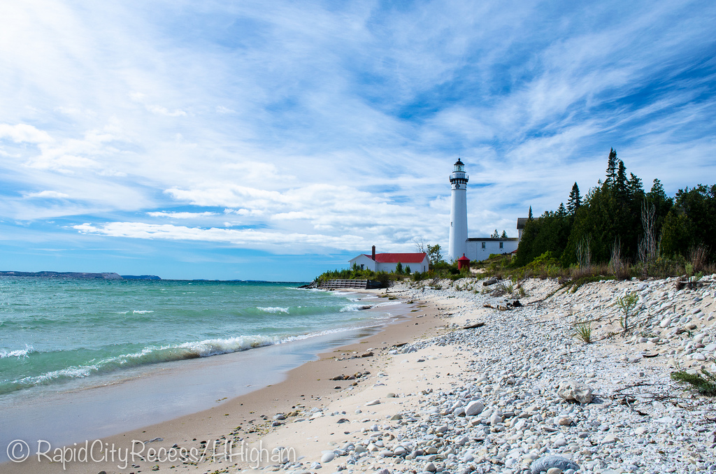
Seul Choix Lighthouse, MI, photo by Wrong Main

We’ve covered the Haunting of Seul Choix Lighthouse on Michigan in Pictures. Dave Wobster has an article on Seul Choix Light at Boatnerd.com. He writes that Seul Choix (“only choice” as the only safe harbor in the area) was popular with Native Americans as early as the 1600s due to the abundant  whitefish and lake trout that were waiting to be caught in Lake Michigan. A fishing village was established in the  mid 1800s and a trading post around 1850.

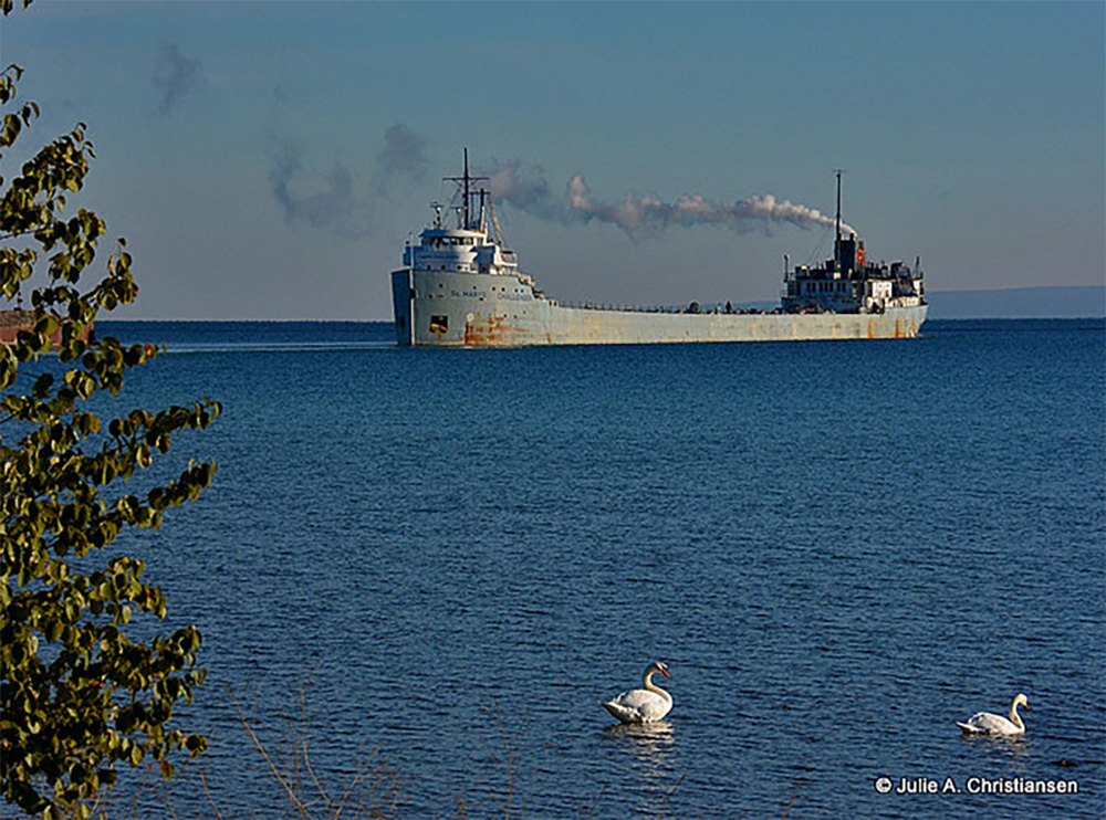
The early navigation aids along the northern Lake Michigan coast were the lighthouses at St. Helena Island (1872) and Peninsula Point (1866). This left a 100-mile gap of dark shoreline with Seul Choix Bay located near the middle. Efforts were soon started to have a lighthouse constructed on Seul Choix Point. The efforts were successful in 1886 when Congress appropriated $15,000 to build a light tower and fog signal on the point. Another $8,000 was added before the project was completed. Various complications and the rebuilding of the original tower delayed completion of the station.The light was first shown in August, 1892, but the complex was not completed until 1895 with the finishing of the fog signal building. The complex consisted of the present conical 78-foot tower and attached 2-story keeper’s dwelling, a steam fog signal building, stable, boathouse, two oil storage buildings, a brick privy, and boat dock and tramway to the fog signal building.

The keeper’s dwelling was expanded in 1925 with a lean-to addition to the west side. The interior living space was divided with a wall to provide equal space for an additional family. The wall has since been removed, but the building still contains two kitchen areas. Particular attention should be paid to the unique rounded gables on the east end of the dwelling. While they are reminiscent of a sailing schooner stern, history does not provide a reason for this detail.

The 78-foot high white conical tower is the typical elaborate “Poe-Style” named after General Orlando M. Poe who provided the original design. The Poe-style light towers are easily recognized by the ornate brackets which support the gallery around the lantern room and the four windows below the gallery which have semi-circular stone arch head pieces.

Read on for more including some photos of Seul Choix details at Boatnerd.com. The Seul Choix Pointe Lighthouse is maintained by the Gulliver Historical Society and you can get a lot more info (and a snippet of a cool song that plays when you load) at their site.

Bill took this shot in 1997 with Plustek OpticFilm 7600. He writes that Seul Choix is located on the north shore of Lake Michigan a little east of Manistique. View his photo background big and see more in his great Lighthouses slideshow.

Many (many) more Michigan lighthouses at Michigan in Pictures!

View of Manitou Islands from Sleeping Bear Dunes

View of Manitou Islands from Sleeping Bear Dunes

View of Manitou Islands from Sleeping Bear Dunes, photo by jess_clifton

Last week’s Leelanau Enterprise is reporting that October 2013 had the lowest number of Sleeping Bear Dunes visitors in a decade – an impressive testimony to the impact of our recent government shutdown. You’ll be able to read the article in a month … when it’s no longer news I guess.

Jess took this from the Pierce Stocking Drive a week ago. Check it out background bigtacular and see more in her Sleeping Bear Dunes slideshow.

More dunes on Michigan in Pictures.

100 Years after the Great Storm of 1913

NovemberGaleGrandHaven-2

NovemberGaleGrandHaven-2, photo by Rich Wyllis

100 years ago today the most devastating storm in Great Lakes history began. It raged across the Great Lakes from November 7-10, 1913. As NOAA’s commemorative website explains:

In November of 1913 the Great Lakes were struck by a massive storm system combining whiteout blizzard conditions and hurricane force winds. The storm lasted for four days, during which the region endured 90 mile per hour winds and waves reaching 35 feet in height. With only basic technology available, shipping communication and weather prediction systems were not prepared for a storm of such devastating force. When the skies finally cleared, the Great Lakes had seen a dozen major shipwrecks, an estimated 250 lives lost, and more than $5 million in damages (the equivalent of more than $117 million today).

Nicknamed the “White Hurricane” and the ‘Freshwater Fury” the 1913 storm remains the most devastating natural disaster to ever strike the Great Lakes. One hundred years later, NOAA commemorates the Storm of 1913 not only for the pivotal role it plays in the history of the Great Lakes but also for its enduring influence. Modern systems of shipping communication, weather prediction, and storm preparedness have all been fundamentally shaped by the events of November 1913.

Head over to NOAA for more on the weather technology of 1913 and today and definitely check out more on the Freshwater Fury on Michigan in Pictures!

Check Rich’s photo out bigger and see more in his slideshow.

The Oldest Ship on the Great Lakes: The St. Mary’s Challenger

Departing…….. by smiles7

7 years ago I shared the story of the Southdown Challenger on Michigan in Pictures. I was happy to see that the oldest operational freighter on the Great Lakes is still in action. The feature on the St. Marys Challenger on Boatnerd.com begins:

Currently holding the honors of being the oldest lake boat still trading on the Great Lakes, the self unloading cement carrier St. Marys Challenger was built as a traditional Great Lakes bulk carrier as hull #17 by Great Lakes Engineering Works, Ecorse (Detroit), MI in 1906. This veteran of the lakes was launched February 7, 1906 as the William P. Snyder for Shenango Steamship & Transportation Co. (subsidiary of Shenango Furnace Co.), Cleveland, OH. Retaining her original overall dimensions, the St. Marys Challenger is now powered by a Skinner Marine Unaflow 4 cylinder reciprocating steam engine burning heavy fuel oil rated at 3,500 i.h.p. (2,611 kW) with 2 water tube boilers. The power is fed to a single fixed pitch propeller and the vessel is equipped with a bow thruster. The vessel is capable of carrying 10,250 tons (10,415 mt) in 8 holds at mid summer draft of 21’09” (6.63m). Cargoes of bulk or powdered cement can be unloaded by a fully automated system including air slides, conveyor equipment and bucket elevators feeding a forward mounted 48’ (14.63m) discharge boom.

Of note, the St. Marys Challenger is one of only two remaining U.S. flagged vessels still active on the Great Lakes to be powered by the classic Skinner Marine Unaflow steam engine. The other vessel is the car ferry Badger (2) which is powered by two of these engines and, in turn, remains as the only coal fired vessel still in active service on the Great Lakes. The only remaining Canadian-flagged steamer powered by a Canadian-built (Vickers) Skinner Unaflow engine is the James Norris.

Read on for more and also check out this set of photos by Wade Bryant, who served aboard the Challenger.

Julie took this shot as the St. Marys Challenger steamed out of Charlevoix last week. Check it out bigger and see more in her boat slideshow.

Many more Michigan ships & boats on Michigan in Pictures!

Support Michigan in Pictures with Patreon

Mr. Shutdown comes to Michigan

North Bar Overlook by Ken Scott
North Bar Lake … overlook by Ken Scott

A taste of the Shutdown’s impact on Michigan via Leelanau.com…

The TC Ticker reports that the federal government shutdown that began at midnight has closed portions of the Sleeping Bear Dunes National Lakeshore:

A park representative said gates will be closed on the park’s campgrounds, bathrooms and popular Pierce Stocking Scenic Drive until the shutdown ends, though visitors may still access the park’s hiking trails and lakeshore(our emphasis)

Sleeping Bear Dunes is one of five national parks in Michigan affected by the shutdown, a move that comes at an unfortunate time for tourism-dependent parks nearing the end of their operating seasons. The Leelanau County attraction, which will operate with a skeleton crew of emergency-only personnel until the shutdown has ceased, normally averages 2,300 visitors a day during the fall season, according to park reports.

The Freep reports that a similar scenario will unfold at other Michigan National Parks with Isle Royale & River Raisin Battlefield Park closing early for the season. Let me stress that you can still enjoy the majority of our parks and trails. In other Michigan-specific news, about 900 Michigan National Guard members are bracing for a furlough notice and training for another 12,000 will be put on hold. More details on the shutdown’s impact on Michigan at mLive.

Check Ken’s photo – taken at a location that will be inaccessible – out bigger and see more in his massive Panoramas slideshow.

South Manitou Island Lighthouse

South Manitou Lighthouse

South Manitou Lighthouse, photo by HLHigham

Terry Pepper’s Seeing the Light is a tremendous resource for Michigan lighthouse information. His entry on the South Manitou Island Lighthouse begins:

Located just off the mainland coast of Lake Michigan’s east coast, a group of islands known as the Beaver Archipelago form a chain which marked the western edge of a tight passage along the coast. Known as the “Manitou Passage,” vessel masters taking this narrow passage were able to reduce the travel distance between the ports of Lake Michigan’s southern shore and the Straits of Mackinac by sixty miles, as opposed to taking the more circuitous route through open water to the west of the islands. As the most southerly of this chain of islands, South Manitou also featured one of the areas safest natural harbors, and with 5,260-acres of fine timber growth covering the island, it is not surprising that a few enterprising settlers arrived during the mid 1830’s to sell firewood to steamers taking shelter in the harbor when things turned sour out in the lake. By the late 1830’s it was commonplace to find upward of fifty vessels crowded into the harbor seeking refuge and taking-on supplies when things turned sour out in the lake.

Lying a scant few miles west of Sleeping Bear Point, mariners were hard pressed to locate the southern entrance to the busy passage at night or in times of thick weather, and a cry arose throughout the maritime community to light the southern entrance to the passage. Taking up their call on February 19, 1838, Michigan State Representative Isaac Crary entered a motion before the House of Representatives to erect a lighthouse on South Manitou, and fully cognizant of the vital role played by maritime commerce in the area, Congress responded quickly with an appropriation of $5,000 for the station’s construction on July 7 of that same year.

You can read on at Seeing the Light for the troubled saga of this light which saw high keeper turnover and some tragedy in its long tenure before being decommissioned in 1958. There’s also historical photos like this one showing the structure in full operation.

The light & South Manitou Island are now part of the Sleeping Bear Dunes National Lakeshore. Click that link for visitor information and also check out this satellite view of the South Manitou Light!

Check this out background bigtacular and see more shots of the light and the island in Heather’s South Manitou Island slideshow.

Many more lighthouses on Michigan in Pictures!

Our Great Lakes would be a lot less pretty with Asian carp

Lake Michigan near Brevort, Michigan

Lake Michigan near Brevort, Michigan, photo by daveumich

I tried to find something amazing about Lake Michigan – a poem, a legend, anything – but I really couldn’t find something to match up with this stunning photo. I’ll fall back on the real & urgent need to protect the beauty of Lake Michigan and the rest of the Great Lakes from the  very real threat of Asian carp.

Asian carp just suck: massive, leaping fish that seriously injure boaters and eat everything else in the lake. They would be an apocalypse for the $7 billion Great Lakes fishing industry, and it is estimated that just 20 fish getting in would be all it would take.

So of course, yesterday John Flesher (IMO the best environmental journalist in the Great Lakes who also happens to be my neighbor) wrote an article on Asian carp that begins:

The recent discovery of a large Asian carp near Chicago underscores the need to protect the Great Lakes from the voracious fish and other invasive species that could slip into Lake Michigan, two members of Congress said Tuesday.

“If Asian carp are not stopped before they enter the Great Lakes, they could destroy the ecosystem, as well as the boating and fishing industries, and hundreds of thousands of jobs,” said Sen. Debbie Stabenow, a Michigan Democrat.

…John Goss said the 53-inch, 82-pound fish was caught about a month ago in Flatfoot Lake, on the Illinois-Indiana state line.

Flatfoot Lake is landlocked and surrounded by a berm that would prevent it from flooding and enabling Asian carp to escape, said Chris McCloud, spokesman for the Illinois Department of Natural Resources.

But it’s very close to Chicago’s Lake Calumet, where commercial fishermen landed a 3-foot-long Asian carp in 2010 about six miles from Lake Michigan. Lake Calumet and Lake Michigan are connected by the Calumet River.

The latest find “is another reminder that we must find a permanent solution to protect the Great Lakes,” Rep. Dave Camp, a Michigan Republican, said Tuesday.

Indeed. How about we work on that? The Great Lakes are far too beautiful to be filled with the likes of Asian carp. If you agree, please share this with others. We can do something about this threat to our lakes.

Check this photo out background bigtacular, see more in Dave’s slideshow and also check out his photography website, Marvin’s Gardens including a shot of what I’m pretty sure was his breakfast up on Brevort Lake!

Regrettably, there’s more Asian carp on Michigan in Pictures.

Charlevoix, the Beautiful

Charlevoix the Beautiful

Charlevoix the Beautiful, photo by GLASman1

Wikipedia entry for Charlevoix (pronounced shar-le-voy) says:

The city is situated between Lake Michigan and the western end of Lake Charlevoix, which drains into Lake Michigan through the short Round Lake/Pine River complex in the heart of downtown Charlevoix. Charlevoix’s Round Lake has been called the best natural harbor on Lake Michigan.

Charlevoix is named after Pierre François Xavier de Charlevoix, a French explorer who travelled the Great Lakes and was said to have stayed the night on Fisherman’s Island one night during a harsh storm. It was during this time that Native Americans were thought to have lived in the Pine River valley.

The City of Charlevoix website adds that Charlevoix first became a village in 1871 and was later established as a city in 1905. The city has a year round population of roughly 3,000 people. FYI, Round Lake is the little lake right off Lake Michigan whick opens into the much larger Lake Charlevoix – here’s a map of Charlevoix!

View Mark’s gorgeous aerial photo bigger and see more in his Aerials slideshow.

There’s more aerial photography and more about Charlevoix on Michigan in Pictures!

Grand Mere Dunes is cooler than you think

Grand Mere Dunes

Grand Mere Dunes, photo by mswan777

Grand Mere State Park is located on the southwestern shore of Lake Michigan near Stevensville. The Environmental Protection Agency’s Sand Mine Restoration Plan explains that Grand Mere:

…contains some of the most unique sand dune features in the world. The park also contains three lakes, called North, Middle, and South Lake, and has over one mile of Lake Michigan frontage. The sand dunes within the park are part of the largest freshwater dune system in the world, lining the shores of the Great Lakes. These dunes historically supported a wide array of natural communities, including dry-mesic southern (oak-hickory) forest, rich conifer (cedar) swamp, southern (mixed hardwood) swamp, wetpanne and interdunal wetland (shrub swamp/emergent marsh), open dunes, and a wooded dune and swale complex.

The dunes at Grand Mere fall within a state-designated “Critical Dune Area.” The area containing the present-day park was also designated a National Natural Landmark in 1968. The park was first created on 393 acres of land in 1973, and more than doubled in size with the acquisition of 490 additional acres in 1986. The master plan for Grand Mere State Park, approved in 1986, cited “sand dune preservation” as the primary management objective for the park. A highly diverse flora exists at Grand Mere, with over 550 species of plants documented within the park. Furthermore, Grand Mere lies in a unique place on the southern shore of Lake Michigan where plants typical of both northern and southern temperate latitudes grow together in the same community. Because of the unique flora, fauna, and geology of the dune and wetland features at Grand Mere, the park has long been used as an “outdoor laboratory” for natural resource teaching and research.

…Within the park, the dominant landforms are the sand dunes along the shore of Lake Michigan. A large  bay of the glacial Great Lakes was present where Grand Mere State Park is today. During Algonquin  Great Lakes time (roughly 12,000 years ago), a large spit formed from the south along the west side of the  bay, nearly cutting it off from the glacial lake (Tague 1947). Most of the dunes at Grand Mere formed on  this Algonquin sand spit during the later Nipissing Great Lakes period, approximately 4,500 years ago.  During the more recent post-Algoma period (3,000 years ago until present), a smaller spit from the north  merged with the larger, dune covered southern spit, closing off the bay. As water levels fell, five lakes  formed in this bay. The two southern lakes have subsequently filled in and have become the present-day  tamarack swamp south of South Lake. While the lakes were forming in the bay as water levels fell, some  smaller foredunes were formed along the shoreline of Lake Michigan. The topography and sandy soils of  the park can be attributed to this glacial history.

Read on for more about the history & geology of this unique park, and check out Grand Mere State Park on the Absolute Michigan Map.

View Mark’s photo background big and see more in his Michigan –  Color slideshow.

More dunes on Michigan in Pictures.

Going for the gold

SUP'rs ... going for the 'gold'

SUP’rs … going for the ‘gold’, photo by Ken Scott

It’s hard to believe that Summer 2013 is almost in the books. I hope you’ve had fun and that you get a chance to grab a little more “summer gold” this weekend!!

Check this out bigger and see more in Ken’s Benzie slideshow.