The Colors of Omena

The Colors of Omena

The Colors of Omena, photo by Elijah Allen

Here’s a shot by a friend taken just north of me showing the incredible fall color that’s still out there along the Lake Michigan coast. It was taken from off Omena Point at the northern part of the Leelanau Peninsula, so how about a little Omena history courtesy the Omena Historical Society?

The Omena settlement had its beginnings when Aghosa Indians started arriving in 1850. In 1852, the Reverend Peter Dougherty and a band of Ottawas and Chippewas led by Chief Ahgosa moved from the present-day Old Mission Peninsula to a beautiful little bay on the Leelanau Peninsula’s eastern side. Chief Shabwasung and his Ottawa band were already encamped on the point to the north of the bay, on land Chief Ahgosa and his families from Old Mission had purchased. Ahgosa settled a little to the north, and his village became Ahgosatown. Both bands became part of the New Mission, soon to be called Omena.

Young George A. Craker came with Dougherty and taught farming to students in the mission school, and he and his descendants became active workers in Dougherty’s Grove Hill New Mission Church. Now called the Omena Presbyterian Church, it was dedicated in 1858 and has stood as the oldest Protestant Church in Leelanau County and one of the oldest historical landmarks in Northern Michigan. The Ahgosa family was also very active and some are now buried in the mission cemetery.

Click through to read more and for some historical photos of Omena.

View Elijah’s photo bigger on Facebook and scroll though when you get there for more!

More aerial photos, more history and more Leelanau on Michigan in Pictures.

Otter Creek Aurora

Otter Creek Aurora

Otter Creek Aurora, photo by Snap Happy Gal Photography

This is one shot from an incredible video that Heather made of the northern lights as seen from Esch Road Beach in the Sleeping Bear Dunes National Lakeshore. That’s Otter Creek in the foreground.

Click to view bigger, follow Snap Happy Gal on Facebook, and definitely watch that video – meteors!!

Lots more northern lights on Michigan in Pictures.

This salmon is going up. The salmon population in Lake Michigan is headed the other way!

EDITOR’S NOTE: It looked for a minute that we had another Turtlegate brewing and that this might not be a Chinook but a brown trout. Read more in the comments on Facebook.

Salmon up and over the dam

Up & Over……….., photo by Julie

The Detroit Free Press reports that the salmon population is plummeting in Lake Michigan. The article begins:

They are the king of the Great Lakes sport fish, luring thousands of anglers to Michigan waters every year for a chance to try to land them — and helping fuel a multibillion-dollar fishing and boating tourism industry.

But the Chinook salmon’s numbers are plummeting in Lake Michigan due to a combination of natural forces, unnatural invasive species, and the state Department of Natural Resources’ own efforts to dial back the population and prevent a more permanent population crash as happened in Lake Huron about a decade ago.

The salmon population on Lake Michigan is down 75% from its 2012 peak, said Randy Claramunt, a DNR Great Lakes fishery biologist based in Charlevoix.

A leading cause is a reduction in alewives, a silvery fish up to 10 inches long that is the salmon’s primary prey on the Great Lakes. The alewife population has been decimated by invasive zebra and quagga mussels that have changed the nutrient dynamics of the lakes.

Read on for more at the Freep.

View Julie’s photo of a salmon jumping up into the weir at Charlevoix bigger and see more in her Wildlife slideshow.

More about Chinook salmon and more fish on Michigan in Pictures.

Artprize 2015 and the Sands of Time

Sands of Time

The Sands of Time, photo by Tony Reidsma

Tony Reidsma is one of the photographers I’ve featured on Michigan in Pictures who has an ArtPrize exhibit this year. His entry at ArtPrize says:

This exhibit focuses on the ever-changing shape of the shores of Lake Michigan. The lakeshore is currently experiencing erosion similar to that of the mid-1980’s and late-1990’s. At that time those dwelling on the lakeshore hastened to build the seawalls and jetties which would fortify their properties and homes from the obliterating effect of the waves pushing out of the rising water. Eventually, as the water receded, the sand returned to build up the shoreline and bury the wooden structures that were erected there.

Now, as Lake Michigan moves through its rhythms once again, the water is advancing and the sands retreating, exposing the old, decaying seawalls. I have created a photo-journal of this changing shoreline scenery, featuring the old seawalls and jetties as aged reminders of the cycles which are characteristic to our natural world.

You can watch an interview with Tony at WOOD-TV, learn more at the ArtPrize page on his website and check the exhibit out in person at Crossroads Bible Church (800 Scribner NW).


Way above the Mighty Mac

Mackinac Bridge from Above

The Mackinac Bridge, photo by FotoLense

Well while we’re up in the air (see yesterday) why not stay there?

View this photo background bigtacular and see more including some more aerials from the area in FotoLense’s Mackinac Island July 2013 slideshow.

There’s some great facts about the Mackinac Bridge if you click the photo and a ton more on the Mighty Mac from Michigan in Pictures!

Free Birds

free Birds

Free Birds, photo by David Clark

Here’s a pretty cool shot taken last weekend from high above the Sleeping Bear Dunes National Lakeshore and Lake Michigan. For reference, if he took this from where I think he did, those people are above a dune bluff that’s several hundred feet high.

View David’s photo big as the sky and see more in his Sleeping Bear 2015 slideshow.

Van’s Beach

Northern Way Of Life

Van’s Beach in Leland, photo by Northern Way of Life

Van’s is the most popular public beach in my hometown of Leland for reasons that are probably made obvious by this photo. When Traverse City Tourism shared the picture, I figured I should too!

The Leelanau Conservancy has this to say about Hall Beach, also known as Van’s Beach:

The beach is Leland’s first public beach on Lake Michigan since the harbor was constructed in 1970. It lies at the base of the south breakwall of the harbor and was originally owned by the Hall family. The beach area was made possible by the Hall Family and the Michigan Natural Resources Trust Fund.

It lies at the base of the breakwall and connects Fishtown to the rest of the public beach to the south which was gifted by the Miller Taylor families. Linked together, these areas create an uninterrupted protected area from Fishtown to where the trail comes down to the water from the parking area at the road end of Cedar street – for both wildlife and public to enjoy. A favorite place for watching Lake Michigan sunsets, Hall Beach also protects historic Fishtown from future commercial development.

Click through for a map and to see more beaches and preserves on the Leelanau Peninsula.

I will add that Van’s beach got its name from Van’s Garage, owned by the Van Raalte family. Also, when the wind is from the north or northwest this is one of the area’s best surf spots. The point you can see in the distance is Whaleback, also preserved by the Leelanau Conservancy.

View the photo bigger on Facebook, see several more in the Traverse City Tourism feature and definitely follow Northern Way of Life on Facebook for lots more from the Leelanau Peninsula & Northern Michigan.

More Michigan beaches on Michigan in Pictures.

Waterspout at Muskegon State Park

Lake-Michigan-Waterspout Muskegon Beach

Waterspout at Muskegon State Park, photo by Joe Gee Photography

Summer of 2015 has definitely featured some wild weather. Photographer Joe Gee captured this dramatic photo last Monday at Muskegon State Park. mLive featured Joe’s waterspout photo along with an explanation of the phenomenon by meteorologist Mark Torregrossa:

This is the waterspout season on the Great Lakes, but tonight’s waterspout did not occur in the classic waterspout weather pattern.

Waterspouts form mostly due to a large temperature difference between the water surface and the air a few thousand feet above. So the classic waterspout weather pattern would have a large, cold upper level storm system moving over the Great Lakes. That storm system is still well to our west, and won’t pass through until Wednesday.

This waterspout still most likely formed due to a temperature difference between the water and the air. The cold air aloft wasn’t really detectable because it was so isolated.

The other weather feature probably contributing to the development of this waterspout was a lake breeze or even possibly an “outflow boundary” from another storm. The lake breeze blows a different wind direction into the storm and can cause additional rotation. An outflow boundary coming off another thunderstorm can do the same thing.

So this waterspout is a less threatening rotation as compared to a tornado. Usually these waterspouts dissipate before they come onshore.

This time of year is the typical time for waterspouts because of two weather features. First, the Great Lakes water temperatures are usually warmest right now. Secondly, we have to mention the word fall. Cooler, fall-like air starts to move in at this time of year. The temperature difference is largest now through September.

You can purchase a print right here and follow Joe and his work at joegeephotography.com and on Facebook.

More wild weather on Michigan in Pictures!

The Indian Drum

petoskey-breakwall-wave

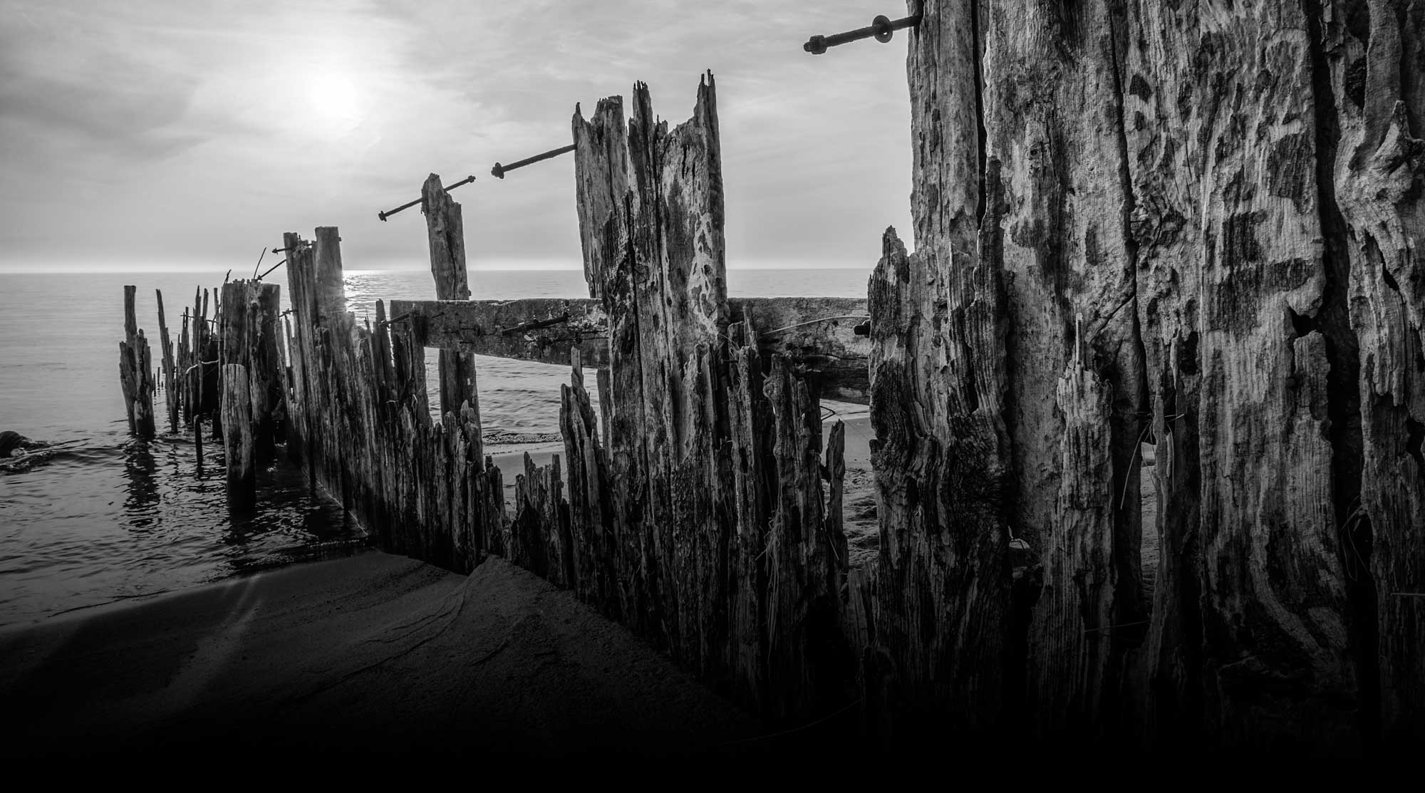
Petoskey Breakwall, photo by Julie A. Christiansen

Earlier this week I posted about The Crooked Tree. While August isn’t yet shipwreck season in Michigan, the post reminded me of the 1915 novel by William MacHarg & Edwin Balmer set in the same region called The Indian Drum. The whole book is available online at Project Gutenberg (hooray for free books!). It begins:

Near the northern end of Lake Michigan, where the bluff-bowed ore-carriers and the big, low-lying, wheat-laden steel freighters from Lake Superior push out from the Straits of Mackinac and dispute the right of way, in the island divided channel, with the white-and-gold, electric lighted, wireless equipped passenger steamers bound for Detroit and Buffalo, there is a copse of pine and hemlock back from the shingly beach. From this copse—dark, blue, primeval, silent at most times as when the Great Manitou ruled his inland waters—there comes at time of storm a sound like the booming of an old Indian drum. This drum beat, so the tradition says, whenever the lake took a life; and, as a sign perhaps that it is still the Manitou who rules the waters in spite of all the commerce of the cities, the drum still beats its roll for every ship lost on the lake, one beat for every life.

So—men say—they heard and counted the beatings of the drum to thirty-five upon the hour when, as afterward they learned, the great steel steamer Wenota sank with twenty-four of its crew and eleven passengers; so—men say—they heard the requiem of the five who went down with the schooner Grant; and of the seventeen lost with the Susan Hart; and so of a score of ships more. Once only, it is told, has the drum counted wrong.

At the height of the great storm of December, 1895, the drum beat the roll of a sinking ship. One, two, three—the hearers counted the drum beats, time and again, in their intermitted booming, to twenty-four. They waited, therefore, for report of a ship lost with twenty-four lives; no such news came. The new steel freighter Miwaka, on her maiden trip during the storm with twenty-five—not twenty-four—aboard never made her port; no news was ever heard from her; no wreckage ever was found. On this account, throughout the families whose fathers, brothers, and sons were the officers and crew of the Miwaka, there stirred for a time a desperate belief that one of the men on the Miwaka was saved; that somewhere, somehow, he was alive and might return. The day of the destruction of the Miwaka was fixed as December fifth by the time at which she passed the government lookout at the Straits; the hour was fixed as five o’clock in the morning only by the sounding of the drum.

The region, filled with Indian legend and with memories of wrecks, encourages such beliefs as this. To northward and to westward a half dozen warning lights—Ile-aux-Galets (“Skilligalee” the lake men call it), Waugaushance, Beaver, and Fox Islands—gleam spectrally where the bone-white shingle outcrops above the water, or blur ghostlike in the haze; on the dark knolls topping the glistening sand bluffs to northward, Chippewas and Ottawas, a century and a half ago, quarreled over the prisoners after the massacre at Fort Mackinac; to southward, where other hills frown down upon Little Traverse Bay, the black-robed priests in their chapel chant the same masses their predecessors chanted to the Indians of that time. So, whatever may be the origin of that drum, its meaning is not questioned by the forlorn descendants of those Indians, who now make beadwork and sweet-grass baskets for their summer trade, or by the more credulous of the white fishermen and farmers; men whose word on any other subject would receive unquestioning credence will tell you they have heard the drum.

Read on at Project Gutenberg.

Julie took this shot back in November of 2013. You can view it bigger, see more in her This & That slideshow and also check out this video from the day.

More Michigan shipwreck lore on Michigan in Pictures.

Faith

Faith in Grand Traverse Bay

Faith, photo by Cameron

View Cameron’s photo from underneath Grand Traverse Bay background bigtacular and see more in his Elk Rapids MI slideshow.

More great summer wallpaper on Michigan in Pictures!