How to see the Northern Lights in Michigan

October Auroras by Shawn Malone

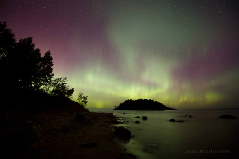
October Auroras by Shawn Malone/Lake Superior Photo

Just in! Shawn told me she just got in from shooting the northern lights last night – check her photo out right here and stay tuned to her Facebook for updates!

NOAA’s Space Weather Prediction Center reported this morning:

Earth is currently under the influence of a coronal mass ejection (CME) and G2 (Moderate) geomagnetic storming has been observed. This is likely the result of what was expected to be a near miss from an event originally observed on the 14th. This CME has a fairly well-organized magnetic field structure so continued G1 (Minor) to G2 (Moderate) storming is certainly possible. Stay tuned for updates as this event unfolds.

The Aurora Borealis was out last night, and I thought it a good time to share Shawn Malone’s Insider Secrets for Northern Lights that she wrote for the Pure Michigan Blog a couple of months ago:

Michigan has a lot of things going for it when it comes to northern lights viewing, the most important being 1). latitude  and 2). relatively low light pollution in many areas.  Northern Michigan sits in a great location latitude-wise, as the auroral oval dips further south on nights of stronger auroral activity.  The Upper Peninsula  is blessed with hundreds of miles of shoreline along the south shore of Lake Superior, which provides some of the best northern lights viewing in the lower 48 due to the very dark night skies.  When looking north over Lake Superior, one can see right down to the horizon and take in a 180 degree unobstructed view of the night sky.  Getting to a location without the obstruction of a treeline or hills is important at our latitude, as many times an auroral display will sit very low on the horizon. Having a dark night sky with little light pollution is necessary when looking for the northern lights, as the light of the aurora is equal to the brightness of starlight.

People often ask me how I’ve been able to see so many northern lights displays over the years and a lot of it has to do with what I mentioned above. I live in Marquette, Michigan which sits centered on the south shore of Lake Superior, and when looking north there’s nothing but lake for hundreds of miles. Marquette and locations nearby have many areas along the lakeshore still publicly accessible, allowing for the opportunity to view the aurora right from the shoreline.

If you’ve never seen the northern lights and want to maximize your opportunity to do so, learn and pay attention to sunspot activity, as that’s what drives the northern lights.

Read on for tips on where to catch these lights, some more photos from Shawn and her incredible, Smithsonian award-winning video Radiance.

View Shawn’s photo bigger on Facebook, follow her Lake Superior Photo page and if you get up to Marquette, check out the Lake Superior Photo Gallery on Front St in downtown Marquette!

Michigan in Pictures has a TON of Northern Lights information & photos that includes the science and stories of this incredible phenomenon.

Support Michigan in Pictures with Patreon

Belle Isle to become state park?

Belle Isle Beauty

Belle Isle Beauty, photo by DetroitDerek Photography

The Detroit News reports that Governor Rick Snyder has made a deal with Detroit Emergency Manager Kevyn Orr for the State of Michigan to lease Belle Isle for 30-60 years:

Under the deal, Detroit will not receive any direct monetary payment for the lease, but state operation of Belle Isle is expected to save the cash-strapped city $4 million to $6 million annually, officials said. The state also plans to apply for grants to invest $10 million to $20 million in the park’s aging infrastructure.

The deal also gives the council, which was largely sidelined when Orr took over City Hall in March, the chance to approve the lease or offer an alternative plan that would save the same amount of money.

Starting Jan. 1, Detroiters and other state residents would be required to have Michigan’s $11-a-year Recreation Passport on their vehicles to enter the park. Pedestrians, bicyclists and individuals using public transportation could get onto the island for free.

The president of the Belle Isle Conservancy said the lease agreement is “a very important step” toward keeping the park in the public’s hands at a time when city assets are being targeted for liquidation in Detroit’s historic bankruptcy.

Under Michigan’s Emergency Manager Law, the Detroit City Council has 10 days to approve the lease or propose an alternative that would save the same amount of money or more. Read on for more.

About his photo Derek writes:

Taken from a few miles away ( 3.4 miles I believe ) on the 63rd floor of the Rencen, Detroit’s Belle Isle Park is one of the most popular summer destinations in the city. The land was purchased in 1879 and opened to the public 10 years later – the park itself was designed by Frederick Law Olmstead, the designer of New York City’s Central Park. Admission is free but on a hot summer day get there early or all the best spots on this 982 acre island will be taken. It is America’s largest City-Owned Island Park.

Check his photo out bigger and get an idea of how cool this island park is in his Belle Isle slideshow.

PS: Go back in time at Belle Isle on Michigan in Pictures.

Mackinac Harbor Sunset

Mackinac-Island-Sunset

Sunset over Mackinac Island Harbor, photo by Stephanie Stevens Photography

Today’s photo is actually one frame of one of the coolest time-lapses I’ve seen, a time-lapse of Mackinac Island Harbor at the end of the day taken from Fort Mackinac that shows the end of the day boat traffic, the clouds playing across the harbor and even a little glow in the dark frisbee at Marquette Park! Click that link to check it out in HD glory on Flickr!

View more from Stephanie on her Flickr and at Stephanie Stevens Photography.

More Mackinac on Michigan in Pictures!

A birthday card from the Grand Hotel

View from West Bluff of The Grand Hotel

View from West Bluff of The Grand Hotel, photo by MI photographer

126 years ago today on July 10, 1887, The Grand Hotel opened for business on Mackinac Island. In honor of Michigan’s most famous hotel, here’s a seldom seen view.

Check it out bigger and see more in MI photographer’s Mackinac Island slideshow.

PS: The lighthouse you can see in the distance is Round Island Lighthouse – click the link to get closer with Michigan in Pictures.

Grand Island National Recreation Area

Grand Island's North Shore

Grand Island’s North Shore, photo by Rudy Malmquist

Whereas Pictured Rocks Day is this Saturday and whereas this blog loves the Pictured Rocks National Lakeshore, I’ve decided to dedicate the week to posting about one of my favorite areas of Michigan. ;)

Wikipedia explains that the Grand Island National Recreation Area is part of the Hiawatha National Forest. The 13,500-acre island is about 8 miles long and is located about a mile off the Lake Superior shore at Munising. Congress made the island a National Recreation Area in 1990 after the U.S. Forest Service purchased it from the Cleveland Cliffs Iron Co.

Grand Island’s geology is an extension of the sandstone strata of the adjacent Pictured Rocks National Lakeshore. Island sandstone cliffs as tall as 300 feet (91 m) in height plunge down into the lake. A 23-mile (37 km) perimeter trail skirts much of the island’s shoreline.

Native Americans quickly found the fisheries around Grand Island to be a resource for seasonal and year-round living. Artifacts from as early as 3300 years before the present (1300 BCE) have been found.

Grand Island National Recreation Area is served during summer months by a tourist ferry and island tour bus. The ferry ride, which is less than 1 mile (1.6 km) long, shuttles between a dock on M-28, northwest of Munising, and Grand Island’s Williams Landing. Ticket fees and an admission fee to the island are charged. During the summer months, the ferry makes several trips to the island each day.

Also see the Forest Service site for Grand Island, a Google Map of the island and the Grand Island Ferry Service which has all kinds of recreation information including the fact that the island has bike-friendly roads & trails! Here’s a video of that gives a taste of biking there, and definitely check out frequent michpics photographer Nina Asunto’s blogs about Grand Island for an in-depth look at this island.

I’m pretty confident that the biking drew Rudy to the island. Get the photo big as Superior and see more work from Rudy in his slideshow.

See the Grand Island North Lighthouse, the Grand Island East Channel Light and more Michigan islands on Michigan in Pictures.

Belle Isle Bolt!

Belle Isle View1D

Belle Isle View1D, photo by TroyMich (fferriolo)

BLAM!! Who’s ready for some spring storms? FYI, this is actually not a lighthouse off Belle Isle, it’s the Detroit Waterworks Intake Crib. You can have a look at on Google Maps.

Check this out big as the sky and in see more Frank’s slideshow.

More wicked weather on Michigan in Pictures!

Can you feel the summer?

Can you feel it.

Can you feel it., photo by Majestic View Photography

I can tell when winter is wearing on folks when the spring & summer pictures start to flood in. I love the fact that we’re having the first normal Michigan winter in years but I can’t wait until the blues & greens and warm days return!

Check this out on black and see more in Dan’s Water’s View slideshow.

More islands on Michigan in Pictures.

Winter Study: Observing Wolves & Moose on Isle Royale

Isabelle being chased by her assailant

Isabelle being chased by her assailant, photo by isleroyalewolf.org

A couple of weeks ago a reader sent me a link isleroyalewolf.org. The website documents the interactions of the island’s wolf & moose population as their decades long dance unfolds on this remote, wilderness island. Their overview explains:

Isle Royale has offered many discoveries… how wolves affect populations of their prey, how population health is affected by inbreeding and genetics, what moose teeth can tell us about long-term trends in air pollution, how ravens give wolves a reason to live in packs, why wolves don’t always eat all the food that they kill, and more. The wolves and moose of Isle Royale also frequently reveal intimate details of their daily life experiences and they have inspired numerous artistic expressions. If we pay attention, they all tell us something important about our relationship with nature. These insights and discoveries are all presented here for you.

Building on the graph above and to develop a deeper understanding, here is more on the history of wolves and moose on Isle Royale. Moose first came to Isle Royale in the early 20th century, and for fifty years, their numbers fluctuated with weather conditions and food abundance. Wolves first arrived in the late 1940s by crossing an ice bridge from Canada. The lives of Isle Royale moose would never be the same.

Every winter since 1958, a team of researchers has spent numerous weeks at Isle Royale observing the lives of these wolves and moose and reporting back. Now they offer a website with photos and detailed reports, a fascinating tale that I encourage you to follow. Today’s photo is from the edition I began with – It’s Complicated. A snapshot:

Isabelle’s signal was surprisingly close. By the time we saw her, she was running for her life, north along the beach of Rainbow Cove. She was being chased by Pip’s two companions. Pip was nowhere in sight. While those two wolves have been eating regularly, Isabelle may not have had a decent meal in weeks, perhaps longer. Isabelle’s half-mile lead was reduced to nothing in just a few minutes.

Definitely read on for photos and a gripping account of these wolves battling and follow the whole 2013 Winter Study as it unfolds (sign up for their email).

More wolves on Michigan in Pictures.

Mackinac Island in Winter

Mackinac Island in the winter

Mackinac Island in the winter by SuzyQ0763, photo by SuzyQ0763

Mackinac Island is one of Michigan’s coolest places, drawing over 10,000 visitors a day for much of the summer. Winter on Mackinac is different though, and something that many of us never get to see.

The Arnold Line says that they keep boats running across until early January. After that, islanders use a six-seater plane operated by Great Lakes Air. Once the straits freeze (usually by February) folks can cross on snowmobiles, following the “bridge” marked by Christmas trees in the snow and ice between the Island and St. Ignace (click for a video).

If you’re interested in checking out the island in winter, the Mackinac Island Winter Festival takes place next weekend (February 1-3) at Great Turtle Park. The fun includes a bonfire cook out, sledding, snow golf, archery, snow volleyball, and broom hockey.

Check Suzy’s photo out background big or view all her photos from a winter’s day on Mackinac Island.

Channel Currents & Longshore Currents at Picnic Rocks

Storm Clouds over Picnic Rocks in Marquette, MI Labor Day 2012

Storm Clouds over Picnic Rocks in Marquette, MI Labor Day 2012, photo by Superior Seasons

Picnic Rocks is a popular beach area in Marquette. I thought that I’d come up with a good story for the name, but instead, I learned about the formation and dangers of what are known as channel & longshore currents. The Marquette National Weather Service explains:

A channel current is caused when water is squeezed between the shore and an offshore structure or feature (such as an island). When water is squeezed it speeds up, thus causing the current. This is like putting a smaller nozzle on a garden hose. When the smaller nozzle is on, the water comes out faster.

This current can be enhanced by what is known as a longshore current, a current that is generated by waves breaking onshore. As waves move onshore, they break in the direction they are moving in order to dissipate their energy. This causes the longshore current. Overtime, the current spans the entire width of the surf zone (the place where you swim). In the case of a channel current, the longshore current can speed up the channeling effect between the shore and the rocks, causing dangerous conditions to develop for those who are walking along the sandbar. The longshore current is maximized during times of higher waves that come in at a 45 degree angle to the shore.

…One could escape a channel current by swimming back to towards the shore. Many people make the mistake of swimming against the current as they are trying to get back to the sandbar. Think of the current as an underwater treadmill. In order to get off the treadmill, one needs to step off to the side of it. The channel current will be moving parallel to shore, so in order to escape, swim perpendicular to the shore.

Read on for more including a diagram demonstrating the best way to escape if you’re caught in these currents. A swimmer recently drowned here and this summer has been a deadly one – please use your knowledge to help others stay safe!

So we don’t end on a down note, let me say that in good weather, Picnic Rocks is a fantastic, natural playground for folks of all ages!!

Check this out background big and in Superior Season’s Marquette slideshow.

More from Marquette on Michigan in Pictures.