

Textures, photo by JamesEyeViewPhotography
View the photo from the Sleeping Bear Dunes background bigtacular, see more in James’ The Great Lakes slideshow, and follow James Eye View Photography on Facebook.
Textures, photo by JamesEyeViewPhotography
View the photo from the Sleeping Bear Dunes background bigtacular, see more in James’ The Great Lakes slideshow, and follow James Eye View Photography on Facebook.

Manitou Islands in the morning, photo by Glen Arbor Artisans
North and South Manitou Island are part of an island chain that extends north to the Straits of Mackinac and includes the Fox Islands and Beaver Island. South Manitou Island is just over 8 square miles in land area and is about 7 miles from Glen Arbor while North Manitou Island is about 22 square miles and a little over 10 miles from Glen Arbor. More about the Manitou Islands from the Sleeping Bear Dunes National Lakeshore.
View the photo bigger, and follow Glen Arbor & Glen Arbor Artisans on Facebook for more photography from Paul!

Ile aux Galets, courtesy Terry Pepper’s Seeing the Light
I just learned about a super-cool cruise for lighthouse lovers that also benefits the Great Lakes Lighthouse Keepers Association. mLive reports:
There are 80 spots available for the trip which takes place in the northern part of Lake Michigan June 5-9. It is presented by the Great Lakes Lighthouse Keepers Association, which oversees the care of two lighthouses in the region. Guests travel aboard the Shepler’s Ferry vessel HOPE and stay at different resorts along the way, including Weathervane Terrace Inn & Suites in Charlevoix and Stone Harbor Resort in Sturgeon Bay, Wisc.
“It’s an awesome thing to do,” said Terry Pepper, executive director. “Lighthouses were built for the mariners so by going out to see them the way they were designed for from the water is unique.”
Click above for more and make reservations at gllka.com. Speaking of Terry Pepper, let’s add another Michigan lighthouse! Via Terry’s excellent Seeing the Light website here’s the Skillagalee Island Light Station:
Skillagalee Island is located some 7.7 miles Southwest of Waugoshance Island on the East side of the approach to the Gray’s Reef Passage. The tiny island represents but a small exposed portion of a large gravel shoal that extends 1.8 miles to its East and a half a mile to the Northwest.
Being very low in elevation, the island is barely visible except from close by, and to exacerbate the problem, the size of its exposed surface fluctuates dramatically with the level of the surrounding water. The island was considered a navigational hazard during the earliest days when the French Voyageurs took the time to name the place “Ile aux Galets,” which translates as “Island of Pebbles.”
A is so often the case, the English speaking mariners and settlers found the French name difficult to pronounce, and “Ile aux Galets” soon unofficially mutated into “Skillagalee.” The anglicized version took hold, and by the mid 1800’s references to the original French name all but disappeared.
While Skillagalee laid claim to many wrecks over the years, the grounding of the A.D. PATCHIN was seminal in the call for the construction of an aid to navigation on the island. The PATCHIN was a 226 foot wood-hulled sidewheel steamer built in Trenton Michigan in 1846. Laden with general merchandise, she was making her way into Grays Reef Passage on September 27, 1850, when the currents pulled her out of line and onto shore at Skillagalee. While her crew managed to escape to safety and the initial damage to her hull was minimal, the weather turned evil and thwarted a number of attempts to pull her free. By late November she had been pounded to pieces, becoming yet another of Lake Michigan’s many victims.
To answer the need for a navigational aid to warn mariners of the shoal’s existence, Congress appropriated the necessary funds to construct a light on Skillagalee Island in 1851. As a result of the exposed location and fluctuating water tables, the tower was in constant need of repair, a cycle that would be repeated throughout the station’s history.
Read on for more and check ou tSeeing the Light for more Great Lakes Lighthouses!

Old Fort [Mackinac] from pasture field, Macinac [sic] Island, Mich., courtesy Library of Congress
“Mackinac is a place largely visited by people from all parts of our country, and I take it from many foreign lands. A National Park is established on the island and I think the military post should be made not only comfortable but attractive.”
-Quartermaster General Montgomery Meigs
It’s a birthday of sorts for Mackinac State Historic Parks which is a treasure trove of our colonial history. The page from Mackinac Parks on Fort Mackinac and the Mackinac National Park explains the birth of the park and how one forward thinking officer may very well have created the model for historical preservation in the park that holds so much of Michigan and the nation’s cultural history:
After Congress created Yellowstone in 1872, Senator Thomas Ferry introduced legislation to create a second park on Mackinac Island. In addition to the island’s attractive history and natural features, the U.S. government already owned much of the island as part of the Fort Mackinac military reservation and the soldiers stationed at Fort Mackinac could act as caretakers. As a result, the park would cost almost nothing, which Ferry knew appealed to the tight-fisted Congressmen of the 1870s. After two years of campaigning, President Ulysses Grant created the Mackinac National Park, the second park in the country, on March 3, 1875.
The park made Mackinac Island even more attractive to Midwestern visitors, and brought changes to Fort Mackinac, where the commanding officer became the park superintendent and a second company of soldiers joined the garrison. The Army finally performed some long-overdue repairs at the fort … Quartermaster General Montgomery Meigs believed that “the fort itself is to the public one of the greatest curiosities within the lands of the park,” and required the fort’s commanding officer, Major Alfred Hough, to repair the post’s aging blockhouses. Although the blockhouses served no military purpose, Meigs knew that they were “among the few relics of the older time which exist in this country,” and believed that “there would be a cry from tourists” if they were destroyed. Fort Mackinac thus became as much a part of the national park as the island’s natural curiosities.
…On September 16, 1895, the last soldiers formally transferred Fort Mackinac and the Mackinac National Park to the state. Although the national park ceased to exist with this transfer, the state immediately created the Mackinac Island State Park, which continues to welcome thousands of Mackinac Island visitors every year.
You can view the photo taken somewhere between between 1880 and 1899 bigger and see more great old Mackinac Island photos in this Mackinac Island slideshow from the Library of Congress.
Lots more from Mackinac on Michigan in Pictures!

Words escape me, photo by Lake Superior Photo
Words escape ME on the beauty of the video that Shawn of Lake Superior Photo shared. The ice caves on Grand Island near Munising didn’t happen this year, a very unfortunate thing for everyone in Michigan who makes their livelihood from winter recreation. However, thanks to the magic of the video below, we can travel back to 2015.
You can view Shawn’s photo from winter of 2015 bigger on Facebook and purchase the photo right here. I can’t stress enough that you should follow Shawn and Lake Superior Photo on Facebook. Please do it.
Now here’s that video. Be sure to turn your volume up and watch in HD – there’s a “boom” from the ice sheet at 4 seconds that’s incredible!

Silhouette of a Moose, photo by Nina
Nina writes that she came upon this moose looking like a fake silhouette against a beautiful backdrop while hiking Albert Stoll Memorial Trail just before sunset at Isle Royale. Read Houghton, Flight to Isle Royale, and the Stoll Trail Incident for lots more including photos on Nina’s blog Black Coffee at Sunrise.
This excellent history of Isle Royale National Park from ParkVision explains how this remote Lake Superior Island became a park and Mr. Stoll’s role:
As early as the 1860’s some visited the island for touring or pleasure. But by the turn of the century a real tourism industry was beginning to exist on the island, fueled in part by the growth of midwestern cities. The first hotel on the island, the Johns Hotel, was built in 1892, and other early resorts were built at Tobin Harbor, Rock Harbor, and Washington Island. By the 1920’s there were a number of sizeable resorts located on Isle Royale and some of the smaller islands surrounding it. The moist, cool air on the island provided a popular escape from the midwestern summer heat and for hay fever sufferers.
The 1920’s also brought an effort to gain preservation of and national park status for the island. This effort was spearheaded by Albert Stoll Jr. of the Detroit News, and it was endorsed by Stephen Mather who visited the island in 1924. The threat of extensive logging of the island’s forests in 1922 enhanced concern about the importance of preservation of the island’s magnificent natural resources. Isle Royale gained a measure of fame as a result of a daring winter visit by plane by Ben East and his companions.
In 1930 the Michigan legislature created the Isle Royale National Park Commission. Establishment of the island and surrounding areas as a national park was authorized when Herbert Hoover signed legislation on March 31, 1931. However, initially no money was authorized for its establishment. The Depression and World War II intervened, and it was not until August of 1946 after all park lands had been acquired that the park was finally dedicated in a ceremony on Mott Island.
Read on for lots more!
View Nina’s photo background big and see more at Black Coffee at Sunrise where she will have further posts from her latest journey!

Sunrise at Little Presque Isle Point, photo by Neil Weaver Photography
The Michigan Department of Natural Resources says in part about a proposed Little Presque Isle Natural Area:
The Little Presque Isle tract is often called the crown jewel of Lake Superior, with its beautiful sand beaches, rugged shoreline cliffs, heavily timbered forests, and unmatched public views.
…The rock comprising the area represents some of the oldest exposed formations of its kind. More than a mile of bedrock lakeshore and cliffs adorns Little Presque Isle, including sandstone cliffs that reach nearly 60 feet high toward the base of Sugar Loaf Mountain. One kind of bedrock, granitic, that occurs here is the least common bedrock type along the Great Lakes shoreline, with less than eight miles occurring in total. This is one of three areas where the public can see these 2.3 billion year old formations in Michigan.
The proposed wilderness area is a local landmark, which has significant historical value. The island was reportedly connected to the mainland sometime prior to the 1930s and was a landing place for early explorers and native inhabitants. Roughly 100 yards off the mainland, the island is accessible by wading hip deep water and offers and opportunity for solitude in a unique and scenic setting.
View Neil’s photo background bigilicious, follow him on Facebook, and visit his website to view & purchase this picture and other Lake Superior photos (and also pics from lots of other cool Michigan locations).
More islands, more sunsets, and more summer wallpaper on Michigan in Pictures.

unbelievable colors in the ice pillars, Grand Island, photo by Lake Superior Photo
On March 1st, Shawn shared this shot from last March on Grand Island. We’ve had nowhere near the ice buildup this year – a year can really make a difference.
Also, I’d like to congratulate her on having (as far as I know) the most popular Facebook page for a Michigan photographer – 201,000+ fans for Lake Superior Photo! If you’re not one of those, I urge you to change that right now.
View the photo bigger and view & purchase her photos at LakeSuperiorPhoto.com.
PS: Just in case you missed it, Michigan in Pictures has a good explanation of what gives ice difference colors.
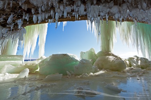
Icicles on cave – Grand Island Ice Curtains, photo by Craig
As the mercury climbs and some crazy people (such as yours truly) start grumbling about the high temps, it’s probably a good time to take a look back at last winter’s spectacular ice caves.
Aubrieta Hope shared the story of her trip with Craig and two other photographers (Neil Weaver & John McCormick) to check out the Grand Island ice curtains. All four are Michigan in Pictures regulars – click to check out In Search of Superior Crystal on the Pure Michigan Blog. It has a bunch of photos and begins:
In the heart of winter, when the drifts are as high as houses and snow-dusted pines line the roads, photographers travel to the Upper Peninsula in search of crystal. Not antique-store crystal, but Superior crystal, the kind that occurs when the north wind turns every drop of open water into something sparkling and new. During the coldest months, the great lake freezes, heaves and breaks, forming mountains of crystal rocks, so tall they seem like permanent landforms. Icebergs and volcanoes rise in the harbors and bays, reflecting all the colors of the sky. Waterfalls slow from a rush to a trickle, building columns that bubble and sing. And, on the sandstone cliffs, springs that flow unseen in the summer months create glittering ice curtains.
During winter’s last stand, at the very beginning of March, I headed north to find Superior crystal. My trip was inspired by winter photographs of the U.P. that I’d viewed online. I’d seen dramatic images of enormous frozen waterfalls, great Superior ice fields, and shining rivers wreathed in morning mist. I wanted to experience and photograph all those scenes, but more than anything, I wanted to see the legendary ice curtains of Grand Island in Munising Bay. These immense, aqua blue ice curtains form when cold temperatures freeze the springs that seep from the island’s rocky cliffs. It can be tricky to get to the ice curtains, though. The island is not accessible every winter because the currents are strong in the bay, preventing adequate ice buildup. During last year’s historically cold winter, the bay froze sufficiently to allow foot traffic. For awhile it looked like Grand Island would not be accessible this year, but February’s arctic blast arrived just in time.
View Craig’s photo bigger and see & purchase more in the Grand Island Ice Curtains – Munising gallery on Craig’s website.
PS: The Grand Island National Recreation Area is located just off the coast of the UP in Munising and is an amazing place, complete with mountain bike trails!
PPS: More ice caves on Michigan in Pictures too!
PPPS: I really am a fan of the PS. If you are too, please PS in the comments!

NE Mackinac Mackinaw Island MI 1930s, photo by Don … The UpNorth Memories Guy … Harrison
I think that it’s pretty clear that Mackinac Island, a living museum boasting an intact Colonial era fort along with many exhibition buildings, The Grand Hotel and other historic businesses and NO CARS, is Michigan’s coolest state park. Today (June 11, 2015), Pure Michigan will be presenting Mackinac Island to the world (well, the internet at least) in a whole new way. They explain:
As the first state in the United States to ever conduct a real-time virtual guided tour, Pure Michigan is offering you the opportunity to experience Mackinac Island – virtually! We’re partnering with Georama, a real-time vicarious travel platform, so you can virtually tour the island just by simply logging into michigan.org/live on Thursday, June 11 at 12 noon to 4 pm Eastern. Tom Daldin, host of PBS show Under the Radar, will serve as your travel guide and adventure lead in this digital exploration.
…Begin your journey by taking a ferry ride to Mackinac Island before getting an up-close and personal view of the island.
We’ll take you to downtown Mackinac, home to some of the most lovely shops and art galleries in the state, offering you a chance to peek inside as well as interact with people on the streets to get their thoughts on the island known as America’s fudge capital. We’ll also tour Douds Market, America’s oldest family-owned grocery store for 131 years so you can see some of the store’s specialty items and get a history lesson on the market.
From there we’ll visit Fort Mackinac and round out our journey with a trip to the gloriously-designed Grand Hotel. We’ll give you a new perspective of this landmark and invite you to join us as we sip tea on the Grand’s famous front porch all while surrounded by 2,500 gorgeous geraniums.
Click through for more and tune in!
View the photo background big and see more of Don’s Mackinac Island postcards & photos on Flickr. Be sure to follow him on Facebook as well!
