Big Boy Graveyard

Big Boy Graveyard

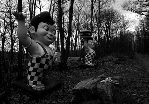
Big Boy Graveyard, photo by Charles Peace

I think that the only thing that is more disturbing than the knowledge that there is a Big Boy Graveyard to someone who grew up yelling “Big Boy! Big Boy!” every time we drove past one is the knowledge that there are (at least) TWO Big Boy graveyards in Michigan. (Detroit area Big Boy Graveyard from dETROITfUNK)

They never tell you about this when you’re in line at the buffet or evaluating which of the menu’s full-color desserts will most make you resemble the smiling icon of Big Boy Restaurants. Even Bob Wian who started Bob’s Big Boy in California in 1936 probably kept quiet about where the Big Boys go when they’re too old to huck hamburgers.

And Fred, Louis, and John Elias, the Elias Brothers who started their mainly Michigan-based Big Boy franchise in 1951? Well, the less said about where they wound up, the better.

Charles is a graduate of Lake Fenton High School (south of Flint) and just received his BFA in Photography from Northern Michigan University. You can check out his portfolio right here.

UPDATE: The Ultimate Upper Peninsula Blog has some photos from the mysterious Big Boy Graveyard.

New Buffalo, Michigan

Sunset over Lake Michigan

Sunset over Lake Michigan, photo by briethe.

There’s not much doubt that as we head up Michigan’s west coast in our shoreline tour, we’ll see a lot of breakwalls and sunsets.

The New Buffalo Township’s excellent history tells us (among other things):

The city of New Buffalo came into being because of a violent October storm in 1834, when Captain Wessel D. Whittaker grounded his schooner Post Boy in the mouth of a small stream called State Creek near the present village of Grand Beach. The ship was destroyed, but Captain and crew survived the disaster and walked to Michigan City, where there were taverns that could provide food and shelter. There Whittaker hired a rig and headed north for St. Joseph to report the ship’s loss to its underwriters. On his way up the coast, he was struck by advantages and beauty of the spot where the Galien River passed through Lake Potawatomi into Lake Michigan. Lake Potowatomi, since drained by the sawmills, was, by varying accounts, two miles long, a half mile wide and up to ninety feet deep or four miles long by a mile wide and fourteen feet deep. It is now just “a lazy bend in the river.”

In addition to all kinds of visitor and business information, The New Buffalo Business Administration has a nice timeline of the history of New Buffalo and a cool old photos of the C&O Railroad Roundhouse that I would very much like to see larger. Maybe it can be found at the New Buffalo Railroad Museum. I also learned at NewBuffalo.com that the nation’s first Highway Travel Information center opened on May 4, 1935, on US-12 at New Buffalo. New Buffalo’s Wikipedia entry is on the lame side, and I would encourage any enterprising New Buffaloeans to spruce it up a little.

You can View a map of photos from New Buffalo and nearby, and explore more of our Michigan Shoreline tour pictures.

Rev. Peter Dougherty House on Old Mission having one heck of a yard sale

Reverend Peter Dougherty House, Old Mission Peninsula

The Dougherty House, Old Mission Peninsula Historical Society

Memorial Day Weekend is the start of many things in Michigan: summer, countdown till school is out, and the yard/garage sale season. On the Old Mission Peninsula just outside of Traverse City, there will be an amazing one at the house of one of the area’s first white settlers, Rev. Peter Dougherty. Once Upon a Time in Old Mission by Walter Johnson explains:

The earliest picture we have of Old Mission comes from the diaries and letters of Rev. Peter Dougherty, a missionary sent here by the Presbyterian Board of Missions in 1838. The Indians here and at settlements along the Lake Michigan shore were Ottawas. There were gardens on the Peninsula, maple trees scarred from sugaring, indicating centuries of human occupancy, and a village at Old Mission. They lived in permanent dwellings built of cedar poles and bark and also wigwams made of evergreen boughs. None of the dwellings had windows, and all of them allowed smoke to escape through a hole in the roof. Chief Ahgosa’s shanty was a little south of Prescott Lake.

According to the terms of the Treaty of 1836, the government was to provide the Indians with missions and schools and Indian reservations. The site of Mission Harbor was personally selected by Henry Schoolcraft between the present School Road and Swaney Road.

Having spent the winter on Mackinac Island, Mr. Dougherty arrived at Mission Harbor near the present Haserot Beach in May, 1839 in a Mackinaw boat. Arrangements were made for opening a school, and Mr. Dougherty’s house was finished before fall, built with logs cut near the border of the harbor and covered with shingles and boards brought from Mackinac. The house was on the shore directly east of the present larger Dougherty house. The second house was the first frame house built in Grand Traverse County, later owned by the Rushmores and used as an inn. In the fall of 1841 there was a schoolhouse and four dwellings. The schoolhouse was used for religious services until the mission house could be built.

Today and Saturday, The Peter Dougherty Society is holding an estate sale to benefit the restoration of the 1842 Dougherty House (article in the Traverse City Record-Eagle). Plans call for an archeological survey of the property, renovation of the house and to open it to the public with  exhibits and tours that will explain its place in the history of not only Grand Traverse, but also as part of the westward expansion of the country in the mid- nineteenth century. While the most historically significant artifacts are being saved for when the house is restored, it sounds as if there are thousands of artifacts spanning over 150 years.

If you’re in the area this weekend, you might want to check this out, and you can also read A Short History of the Dougherty House from the Old Mission Peninsula Historical Society.

The Packard Proving Grounds in Shelby Township

Packard Plant House

Packard Proving Grounds Lodge, photo by Sibylle Basel, Casting Shadow Photography

Sibylle says that photograph is a great art that washes away the dust of every day life. Click the photo above to see more of how she washes the dust away.

The Shelby Township Historical Committee is managing renovations at the Packard Proving Grounds and has some great information and old photos about the site including the text from the front and back of the Michigan Historical Marker:

Packard logoThe Packard Motor Car Company began building a proving ground on this site in 1926. Packard, like its competitors, had previously tested cars on city streets. Architect Albert Kahn designed the principal buildings. By 1929 the complex included the Gate Lodge, warehouses, laboratories, a high-speed test track, and twelve miles of roads simulating the worst conditions of the day. During World War II (1941-1945) Packard built aircraft and marine engines while leasing the grounds to Chrysler for tank testing. Packard ceased production in 1958, and the Ford Motor Company purchased the site in 1961. In 2000 Ford and the Packard Motor Car Foundation began working to preserve the design complex portion of the site.

(back) In 1899 brothers James Ward and William Doud Packard founded the Ohio Automobile Company in Warren, Ohio. In 1902 Detroiter Henry Joy and several other local investors purchased the company, moved it to Detroit and renamed it the Packard Motor Car Company. During the 1920s and 1930s, Packard set the standard for luxury and design. Under the direction of chief engineer Jesse G. Vincent, Packard, known as “America’s Master Motor Builder,” also made advances in aviation technology. Vincent contributed to the development of the Liberty aircraft engine during World War I and predicted the growth of commercial aviation. He considered a proving ground to be essential to high quality.

If you want to get an idea of the full layout, check this aerial photo. Also see Michigan Auto Racing – Packard Proving Grounds, Utica, Michigan at Water Winter Wonderland, Wikipedia’s Packard entry and the National Packard Museum in Warren, OH.

Celebrating 360 degrees of Michigan Week at the Dossin Great Lakes Museum

Gothic Room from the SS City of Detroit III

Gothic Room from the SS City of Detroit III, photo by Mark Houston

In celebration of Michigan Week (May 19 – 25, 2007), Mark Houston over at 360Michigan has posted new panoramas from four locations: the National Trout Memorial (downtown Kalkaska in front of the Kalkaska Historical Museum), the Michigan Fireman’s Memorial (near Roscommon), the Manistee River and the Dossin Great Lakes Museum (Belle Isle, Detroit).

All of these are available as full screen, 360˚ QuickTime VR panoramas and are well worth a look, but the ones of the Dossin Museum really showcase the power of the technology.

The 16,000 square foot Dossin Great Lakes Museum is located on Belle Isle in the Detroit River and is dedicated to showcasing the story of the Great Lakes and Detroit’s role in regional and national maritime history. Permanent exhibits at the museum include the Miss Pepsi hydroplane racing boat, the bow anchor of the Edmund Fitzgerald, the S.S. William Clay Ford Pilot House, the restored smoking lounge of the S.S. City of Detroit III and one of the largest known collection of scale model ships in the world.

Mark has also created a Google map showing the location of all his panoramas.

Detroit’s Penobscot Building – leapable in a single bound?

...leap tall buildings in a single bound. by tEdGuY49

…leap tall buildings in a single bound by tEdGuY49

Narrator: Faster than a speeding bullet. More powerful than a locomotive. Able to leap tall buildings in a single bound… (more)

The plan was to do something on Detroit’s Penobscot Building next week or so … apparently Ted didn’t get the message. Ah well. It looks like May is Detroit Architecture Month on Michigan in Pictures.

To bring things full circle, here’s the intro to the 50s classic Adventures of Superman. Ted just let me know that the intro to Superman was voiced by Bill Kennedy of Bill Kennedy at the Movies fame (on CKLW and later WKBD). Also see this great Detroit News feature The Stars who turned Detroiters into couch potatoes.

Penobscot Building information now here.

David Stott Building, Detroit, in Lego and in fact

The David Stott Building - Lego VersionThe David Stott Building - Actual Version

David Stott Building, Detroit by DecoJim & The Stott by detroitsky

On David Stott Building at MOC Pages, Jim Garrett writes:

This MOC represents the David Stott building, an Art Deco skyscraper that was built in Detroit during 1929 at 1150 Griswold Street. The design of the original building appears to have been influenced by Eliel Saarinen’s 2nd place entry in the 1922 Chicago Tribune building design contest. The David Stott was designed by architects Donaldson and Meier. The building is named after a Detroit businessman who owned a mill and was a boardmember of several other companies. The building remains one of Detroit’s 10 tallest skyscrapers to this day.

Follow that link to MOC Pages for all the details on Jim’s nearly 8′ tall, 54 lb. creation and check out Jim’s Lego Architecture set for more views of this and other skyscrapers.

Wikipedia’s page on the 37-story David Stott is pretty sparse, as is the Stott @ Skyscraper Page. Emporis says the Stott is Detroit’s 13th tallest building. Model D rates the structure #7 on its Top 10 Downtown Buildings of Detroit article and says that the height seems almost exaggerated to be well over 500 feet tall, because of how thin the tower appears and how the setbacks which begin on the buildings 23rd floor, seem to gracefully go on forever.

Here’s a Google map of the location of the David Stott Building (1150 Griswold – at the corner of Griswold & State). Geoff George has a photo of the David Stott mapped as well. You can get more views of the David Stott Building on Flickr.

The Mackinac Bridge: Making Michigan, Michigan

Mackinac Bridge by rdmegr

Mackinac Bridge by rdmegr

The photo by rdmegr was taken from high above the Straits of Mackinac, the name for the narrow passage between the Lower and Upper Peninsulas of Michigan. Lake Michigan is on the left and Lake Huron, the right with Mackinaw City (with a “w”) and the Lower Peninsula in the foreground and St. Ignace and the UP in the distance. It’s part of his Daytrip to Mackinac set of photos. Another photo from his flight to Mackinac of a freighter, the North Manitou Shoal Light and South Manitou Island was also blogged to Michigan in Pictures for general coolness and the fact that I heard his plane fly over my house.

I also have a confession to make: For months, I have been scared of the Mackinac Bridge.

This is distinct from the uneasiness that my mild phobia of falling off the Mackinac Bridge gives me when I drive over it.

Michigan’s Mackinac Bridge - 1957 - 2007I have been scared because 2007 is the 50th Anniversary of the Mackinac Bridge. To me, other than the lake-etched outline of our state, there is no greater symbol of Michigan than the Mighty Mac.

5 miles long, 552 feet tall in nearly 300 feet of water, the Mackinac Bridge has seen over 120 million crossings required 3 years, over 11,000 people and 4 million tons of concrete and steel to build. (more facts)

And that’s only the barest glimmer of the story that needs to be told. From its conception in the 1800s, through the difficult construction, all the way up to the people who cross it for business or pleasure every day with hardly a pause, the Bridge is an essential part of what joins Michigan’s two peninsulas as one state.

If you have some links to share, please add them in the comments. We’ll be telling the story of the Mackinac Bridge piece by piece here and on Absolute Michigan, and we’ll post links to all the photos, stories and videos on The Mackinac Bridge page at Absolute Michigan. (look for the button!)

The Mackinac Bridge

slumpy … the William Livingstone Mansion in Detroit’s Brush Park

Slumpy

slumpy, photo by SOUTHEN

Ryan writes: This is a house in the Brush Park neighborhood in Detroit. A few years ago the home was relocated to the spot it currently sits, but was done so poorly and now sags in the middle. Because of its sag this unique home as been dubbed “Slumpy” by people in Detroit. Its sad and only a matter of time before the home collapses.

Through the magic of FlickrVision, I have been watching Slumpy slump its way toward becoming a pile of rubble for a couple of years. Mac from Detroit BikeBlog (and also Bobby Alcott) pointed out this YouTube video of the front face of the mansion falling off (PG for language). UPDATE! Here’s an even better video (2nd one down). With Slumpy now one step closer to the ultimate end, I thought it would be a good time to dig for a little of the history.

The best I found is at Detroit 1701’s page on the William Livingstone Residence which says:

A prosperous family in Detroit in the 1890s likely wanted to build a home in one of the city’s most elegant neighborhoods. The two most prestigious, arguably, were Brush Park with its numerous mansions or Woodward Avenue where David Whitney and Colonel Hecker had built their castle-like mansion. William Livingstone selected Eliot Street in Brush Park and then employed a very young Albert Kahn who was working for the George Mason-Zachariah Rice firm. When he obtained this commission – presumably with Mason’s help; Kahn was only 22 or 23 years old and had just returned from spending 1891 in Europe studying the classical architecture of the Old World.

Albert Kahn designed in a French Renaissance mode for the home you see, perhaps, reflecting the time he spent sketching the best Gallic architecture. Currently, it takes a great deal of imagination to understand what this once-impressive home looked like in 1893 when Kahn completed it. You can see an interesting array of windows, an appealing tower with its conical roof along with an impressive entryway. This residence was originally built about one block to the west of its present location to the west of John R. The Red Cross intended to demolish this home for their new building. Preservationists succeeded in successfully moving the Livingstone Home about one block to the east.

Wikipedia has a list of buildings designed by Albert Kahn and more information about the architect. They note that as of 2006, Kahn had around 60 buildings listed on the National Register of Historic Places.

Slumptacular Links

Holland, by rail and sail

Interurban electric railroad on the Holland and Lake Michigan Railway

Mabe Bradshaw, the first passenger ship

On July 4, 1898, the first Interurban electric railroad car to carry passengers arrived in Holland. The first rails in Holland had been laid by the Holland and Lake Michigan Railway at River (Avenue) and Eighth Street. These cars are on the track a half-block east of there. More than 100 men and 17 teams of horses constructed the line. The payroll for construction workers was $1,000 weekly. The trains ran from Grand Rapids through Grandville, Jenison, Shack Huddle, Jamestown, Forest Grove, Vriesland, Zeeland, Holland, Jenison Park, Macatawa Park, and Saugatuck. The Interurban freight office was on Eighth Street near Pine Avenue. The passenger train continued south on River and turned west on 13th Street. The line continued near South Shore Drive, stopping near Sunnybrook Station at Virginia Park. Extending south near 160th Street, the train headed to Castle Park and Saugatuck. The train met its demise November 15, 1926.

The first time a passenger ship connected Holland directly with Chicago, via Lake Michigan, was July 4, 1889, when the Mabel Bradshaw docked at the foot of Fifth Street at the old Harrington Dock. That first year the ship made four trips a week, leaving Holland on Sunday, Monday, Wednesday, and Friday evenings, after the arrival of trains at 6:35 p.m. The fare was $2 one way or $3.50 round trip. Owner Hugh Bradshaw named the ship after his daughter Mabel. She was to christen the ship with a bottle of champagne. As she reached for the bow, the bottle slipped from her hand and fell into the water, leaving the ship unchristened. The ship was used for a ferrying service a few years later and spent its last years on Lake Superior.

Be sure to click the photos for a larger view!!

Photos reprinted with permission from Holland: The Tulip Town by Randall P. Vande Water. Available from the publisher online at www.arcadiapublishing.com or by calling 888-313-2665.

View other excerpts from Arcadia Publishing’s Michigan books at Michigan in Pictures!