Hunter’s Point

up_hunter_point_026_m1_screen

up_hunter_point_026_m1_screen, photo by pntphoto.

This photo is part of a set of photos from Hunter’s Point Park near Copper Harbor, Michigan that I think is best viewed as a slideshow (you can also see where it is on a map).

The web site for Hunter’s Point has a neat aerial photo in which you can see the Isle Royale Queen ferry which was captured along with fireworks & northern lights in this photo.

Green Apple at the top of the barrel

20070807_3

green apple, photo by Vaughan.

Michigan in Pictures is graciously hosted by WordPress.com. They are a great company who make a great piece of software and if you are looking for a place to host your blog, I strongly urge you to check them out!

Anyway, this morning I decided to check out the WordPress.com photography page and right there at the top, featured out of hundreds of thousands of possible blogs was a familiar face – Vaughn Nelson, a contributing photographer to Absolute Michigan pool.

So check out Vaughn’s photo blog and say hello – I think you’ll like his look at the everyday of southwest Michigan.

Tiger Stadium, in pictures

Aerial View of Tiger Stadium

Tiger Stadium #1, found by m7k7k7

Many folks in Michigan have a piece of their heart stored at the Corner of Michigan & Trumbull. Wikipedia’s Tiger Stadium entry says the ballpark located in the Corktown neighborhood of Detroit hosted the Detroit Tigers Major League Baseball team from April 20, 1912 when it opened as Navin Field, through its expansion in 1938 when it was renamed Briggs Stadium (and began hosting the Detroit Lions as well) through 1961 when John Fetzer took control and renamed it Tiger Stadium. It saw two World Series championships, 1968 and 1984 and was the home of the Tigers until Comerica Park opened in 2000. It was declared a State of Michigan Historic Site in 1975 and has been listed on the National Register of Historic Places since 1989.

And it’s scheduled for demolition in October of 2007.

From honorary bat boys spending a few moments with a player to huge and cheering crowds, this ballpark has made millions of memories.

Now it waits for the wrecking ball, slowly falling to pieces. I don’t think that too many want to remove the Tigers from their palatial new home, but it would (in my opinion at least) be a wonderful thing if Ernie Harwell and his group could succeed in preserving a scaled-down park at the Corner so none of us have to say goodbye to an old friend (and maybe The Last Strike at Tiger Stadium wouldn’t actually be the last).

Here’s a whole lot more photos in the Tiger Stadium group on Flickr. If you have any photos (or memories) to add, post a comment below!

Read Ernie Harwell’s plan for Tiger Stadium on Absolute Michigan.

In the Pigeon River State Forest…

2007_0703July40155

2007_0703July40155, photo by JJ Murletti.

I don’t know the name of this lake but was struck by just how peaceful it looks.

There’s a campground in the Pigeon River State Forest and lots and lots of trails. The DNR says that the Pigeon River Pine area has over 100 acres of white pine (most about 100 years old) and that the Dog Lake area is considered to be one of the most remote and wild areas in the region. Nesting loons, bald eagles, and osprey are a few of the many animals using the lakes.

The International Mountain Biking Association is quite taken with:

An awesome ribbon of trail looping through the heart of elk country, the High Country Pathway (HCP) embodies the classic definition of an IMBA Epic Ride. The first IMBA Epic Ride in Michigan will take you far into the backcountry with beautiful lowlands and panoramas in the highlands.

Be sure to outfit for self-support, as you may not see another human on this 80-mile soul searcher. The trail passes through a variety of woodlands and wetlands containing massive groves of silver beech, tamarack swamp and leather leaf bogs. The area is home to beaver, black bear, bobcat, pine martin, snowshoe hare, wood ducks, bald eagles, deer, wild turkey and the largest elk herd east of the Mississippi River.

Cruisin’ the Original: Woodward Avenue

Cruising Woodward Avenue in Detroit Michigan

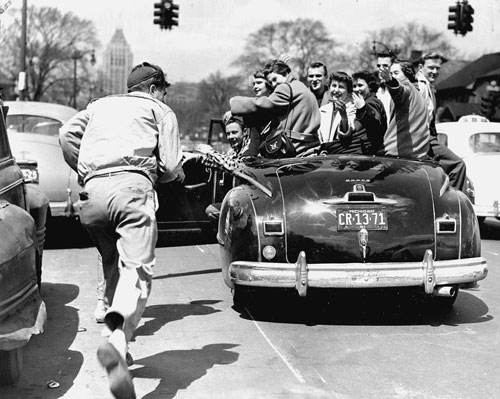
Cruising Woodward, 1951 (above) …the seriousness of the times (1950s) did not dampen a growing love of cars and the freedom experienced by driving them. These young Detroiters found their cars especially useful during the longest transportation strike in the city’s history. In April 1951, the folks here piled into a car not far from the Fisher Building, in the distance, which is across from the General Motors Building in Detroit’s New Center area. After the strike, Detroit mayor Albert Cobo urged the city council to sell Detroit’s streetcars to a willing buyer, Mexico City, for $1 million. The streetcars remained in service there until the 1980s. Detroit soon dismantled its trolley tracks, and only buses ran after that. Cars became the city’s major means of transportation.

Cruisin’ the Original: Woodward Avenue by Anthony Ambrogio and Sharon Luckerman begins: In the 1950s, cruising swept the nation. American streets became impromptu racetracks as soon as the police turned their backs. Young people piled into friends’ cars and cruised their main streets with a new sense of freedom. The Totem Pole on Detroit’s Woodward AvePent-up desires after the hardships of World War II plus a booming economy fueled a car-buying frenzy. To lure buyers to their particular makes and models, automobile companies targeted the youth market by focusing on design and performance. No place was that more relevant than on metro Detroit’s Woodward Avenue, the city’s number-one cruising destination and home of the world’s automobile industry. Barely 50 years earlier, Henry Ford rolled his first Model T off the assembly line at Piquette and Woodward, just south of where cruisers, dragsters, and automobile engineers ignited each other’s excitement over cars. This unique relationship extended into the muscle car era of the 1960s, as Woodward Avenue continued to reflect the triumphs and downturns of the industry that made Detroit known throughout the world.

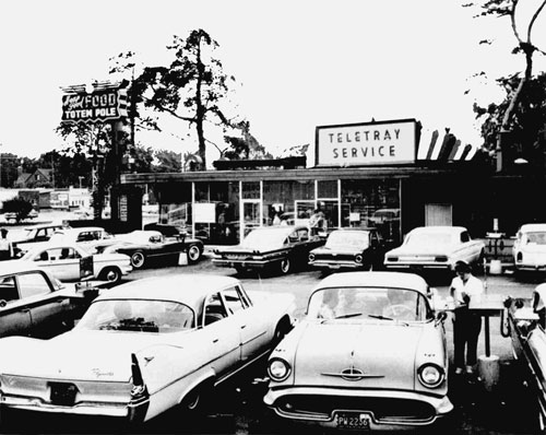
The Totem Pole (right) was the cruisers’ unofficial starting point on Woodward Avenue at Lafayette Street, kitty-corner from the zoo. This 1957 photograph demonstrates the “proper” way cruisers parked—to see and be seen, backed in, like the finned Plymouth in the lower-left corner. (click photo for larger view!)

Funded in part by a grant from the Federal Highway Administration’s National Scenic Byway program and with guidance from the Woodward Heritage Team, Detroit writers Anthony Ambrogio and Sharon Luckerman interviewed numerous local historians, automobile engineers, automobile museum directors, and Detroiters who cruised during these extraordinary decades.

The Images of America series celebrates the history of neighborhoods, towns, and cities across the country. Using archival photographs, each title presents the distinctive stories from the past that shape the character of the community today. Arcadia is proud to play a part in the preservation of local heritage, making history available to all.

Cruisin’ the Original: Woodward Avenue is available from the publisher online at www.arcadiapublishing.com or by calling 888-313-2665.

View other excerpts from Arcadia Publishing’s Michigan books at Michigan in Pictures!

Here’s an action-packed feature on the Woodward Dream Cruise from Absolute Michigan!

Star Trails, the Perseid Meteor Shower and the Tears of St. Lawrence

662px-Perseid_Meteor

2009 Update: The best time to watch the Persied meteor shower in Michigan is TONIGHT (August 11-12, 2009).

The peak of the annual Perseid meteor shower was last night. Postpurchase says he had intended to catch the peak of the perseid meteor shower last night but (alas) the clouds decided not to cooperate. Although last night was the peak, you can see them tonight and I saw a bunch early this morning! (in fact, there was a recent report of Northern Lights at our Northern Lights Log on Absolute Michigan)

SPACE.com has this (and more) to say about the Perseid meteor shower:

Every August, when many people are vacationing in the country where skies are dark, the best-known meteor shower makes its appearance…

The event is also known as “The Tears of St. Lawrence.”

Laurentius, a Christian deacon, is said to have been martyred by the Romans in 258 AD on an iron outdoor stove. It was in the midst of this torture that Laurentius cried out: “I am already roasted on one side and, if thou wouldst have me well cooked, it is time to turn me on the other.”

The saint’s death was commemorated on his feast day, Aug. 10. King Phillip II of Spain built his monastery place the “Escorial,” on the plan of the holy gridiron. And the abundance of shooting stars seen annually between approximately Aug. 8 and 14 have come to be known as St. Lawrence’s “fiery tears.”

Wikipedia’s Persied entry adds viewing tips:

The shower is visible from mid-July each year, with the greatest activity between August 8 and 14, peaking about August 12. During the peak, the rate of meteors reaches 60 or more per hour. They can be seen all across the sky, but because of the path of Swift-Tuttle’s orbit, Perseids are mostly visible on the northern hemisphere.

To experience the shower in its full, one should observe in the dark of a clear moonless night, from a point far outside any large cities, where stars are not dimmed by light pollution. The Perseids have a broad peak, so the shower is visible for several nights. On any given night, activity starts slowly in the evening but picks up by 11 p.m., when the radiant gets reasonably high in the sky. The meteor rate increases steadily through the night as the radiant rises higher, peaking just before the sky starts to get light, roughly 1½ to 2 hours before sunrise.

Kirk Park

Thanksgiving Sunset

Thanksgiving Sunset, photo by wizardkitten.

It’s been 2 weeks since the last Michigan shoreline tour stop at Holland (feels like 2 weeks since I last got on the Michigan shoreline myself!).

While I didn’t find much about the history of Kirk Park at the page Google thinks is best, I did stumble onto this review of the Dune Ridge Trail at Kirk Park from Jim DuFresne’s Best Hikes with Children in Michigan Guide Book (there’s 80 hikes on that page – check it out):

There is a tendency at Kirk Park for children to head straight to the beach. They jump out of the car and hightail it down a paved path to Lake Michigan where they jump into the surf, roll in the sand, or get scorched by the sun. Then their parents take them home, usually waterlogged, sunburnt, and with half a dune in their bathing suits. Should have taken them hiking. At 66 acres and with 2000 feet of lakefront, this Ottawa County park is not large. In fact, it’s basically one dune. But it’s a large dune, and major renovations in the mid-1990s resulted in an intriguing 2-mile trail system over and around this towering hill of sand. The heart of the system is Dune Ridge Trail, a mile-long loop that climbs the hill and then circles the top to reward hikers with excellent views of Lake Michigan.

Cathleen says she likes this park and goes there quite a lot. After seeing her pictures and those from Thomas, Craig (who apparently heeded that “take the trails” advice), Katie, Holly and others, I can see why.

Here’s a Flickr map and also the entry for Kirk Park on our Absolute Michigan map of Michigan.

Silver Lake Sand Dunes

Silver Lake Sand Dunes

Silver Lake Sand Dunes, photo by eyerisimaging.

Just this morning I was looking at videos of trucks, cycles and ORVs tearing over the Silver Lake Dunes.

I have to say that I much prefer this.

I also have to say that this photographer has some stunning photos … check them out.

Two Boats on Little Traverse Bay

Two Boats on Little Traverse Bay

Two Boats on Little Traverse Bay, photo by Graphic Knight.

This photo by Eric S. Chernenkoff is part of his 2007 Summer Vacation Quest set (slideshow). There’s some cool images including this wallpaper-sized shot of an old Lifesaving service boat with the Petoskey pier in the background.

You can view and purchase more photos by Eric at his graphicknight.com web site (he also has a photo blog there)

Lake St. Clair South Channel Lights

Lake St. Clair, Michigan by StormyRed_28

Lake St. Clair, Michigan, photo by StormyRed_28

Lakestclair.net’s page on the South Channel Lights off Harsens Island says:

Lake St. Clair has two lighthouse structures built before Abraham Lincoln was President of the United States. They still stand today just off the southeastern tip of Harsens Island.Construction of the Old South Channel Range Lights started in 1855 and finished in 1859. These lights guided ships into the fresh water delta once known as the Venice of America.

Save Our South Channel Lights is trying to save this endangered pair of lighthouses (also see this article in the Freep about them). There’s a map to their location from Lighthouse Friends.