Warm Wet Winter on tap for Michigan

Water Street During an Ice Storm by Mike McManaman

Water Street During an Ice Storm by Mike McManaman

The National Oceanic & Atmospheric Administration (NOAA) has issued their 2021-2022 winter weather outlook for the US. The NOAA Winter Outlook covers December 2021 through February 2022 and notes that with the La Nina weather pattern, Michigan & the Great Lakes are expected to see warmer & wetter than average conditions. Head over to NOAA for more including weather maps.

Mike took this photo on Flint’s Water Street after an ice storm back on Christmas Eve 2014. See more in his Flint, Michigan gallery on Flickr. 

Support Michigan in Pictures with Patreon

Farlane Friday: Fall Color from Sugar Loaf

Fall Color from Sugar Loaf

Fall Color from Sugar Loaf by Andrew McFarlane

Every so often I like to sprinkle in one of my own photos on Michigan in Pictures, and today is one of those days! I took this photo on October, 22, 2018 at the long-shuttered Sugar Loaf Resort on the Leelanau Peninsula. The ski run was called Devil’s Elbow, and you can see Little Traverse Lake, Lake Michigan, and South Manitou Island & Pyramid Point in the Sleeping Bear Dunes National Lakeshore (shout out to the Lakeshore for yesterday’s 51st birthday!)

While the color isn’t as spectacular this year as 2018, it’s still pretty nice. Also, fun fact: when I was 11 years old an out of control man ran me off the left side of the Elbow. I slid over 100′ down a very steep hill, broke my arm & had to be pulled out by a rope with a snowmobile by the Ski Patrol. You know I was right back at it as soon as the arm healed!!

If you want to read the long & depressing saga of the ski area, head over to Sugar Loaf Resort on Leelanau.com!

Support Michigan in Pictures with Patreon

The Magic Of That Day Was Written In The Sky

The Magic Of That Day Was Written In The Sky by David Hoffman

The Magic Of That Day Was Written In The Sky by David Hoffman

Sweet shot of the view of Lake Michigan from Ludington. See more in David’s Lighthouses gallery on Flickr

Have a great weekend everyone & see more lighthouses on Michigan in Pictures.  

Support Michigan in Pictures with Patreon

Sleeping Bear Dunes National Lakeshore turns 51 today!

Sleeping Bear Dunes National Lakeshore by Thomas DB

Sleeping Bear Dunes National Lakeshore by Thomas DB

(via leelanau.com) On October 21st, 1970 the Sleeping Bear Dunes National Lakeshore became the third US National Lakeshore. The online book A Nationalized Lakeshore: The Creation & Administration of the Sleeping Bear Dunes National Lakeshore has a good overview of what was a remarkably contentious issue back in the day:

A Nationalized Lakeshore: The Creation & Administration of the Sleeping Bear Dunes National Lakeshore Beginning in 1919 a small portion of what is now the national lakeshore was set aside as a state park. The idea of a national park in northwestern Michigan did not surface until the National Park Service’s Great Lakes Shoreline Survey visited the area in 1958. Between 1959 and 1970 there was a continuous and controversial effort in Congress to create a park unit around the Sleeping Bear Dune. The legislative leader of the Sleeping Bear park proposal was United States Senator Philip A. Hart. The senator’s persistence and patience in the end led to the creation of Sleeping Bear Dunes National Lakeshore on October 21, 1970.

Opposition to the creation of the lakeshore was very strong among local summer homeowners. More than 1,400 tracts of private land had to be acquired to create the lakeshore. A heavy-handed, poorly planned land acquisition program reinforced the bitterness that surfaced during the decade of struggle that preceded authorization. The legacy of those actions has been twofold. On one hand the National Park Service has been vilified by many local property owners and the park staff have had to work in an environment that is unnecessarily confrontational. On the other hand, the presence of an organized local populace wary of National Park Service policy has influenced for the better the development of the national lakeshore. Local sentiments played an important role toning-down the agency’s initial plans to intensively develop the area’s recreational assets. More recently local sentiment has influenced the agency’s approach to the lakeshore’s rural cultural landscapes. Unfortunately, resistance to the National Park Service in the region has also hindered opportunities to bring more land under protection and to develop scenic drives for park visitors.

The National Park Service conceived the Sleeping Bear Dunes lakeshore at a time when the shores of Lake Michigan were rapidly undergoing privatization. Subdivisions of vacation and year round homes threatened to keep ordinary citizens from enjoying Michigan’s broad, sandy shoreline. A nationalized lakeshore along the beaches and bluffs of the Sleeping Bear made available for all what might have been enjoyed only by a select few. The cost was millions of dollars of federal funds and the hopes and dreams of hundreds of small property owners. Sleeping Bear Dunes was a tragedy for the latter and a wise investment of the former.

Indeed. You can read lots more in A Nationalized Lakeshore.

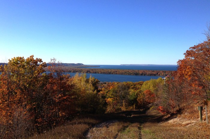
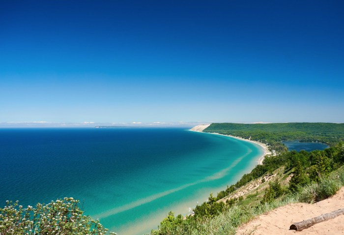
It was hard to pick a photo for this post, but I ended up going with Thomas’s beautiful shot from June of 2016 of my favorite view in the Lakeshore atop the Empire Bluffs where you can see South Bar Lake, the southern end of the main dune complex, and the Manitou Islands in the distance. See more in Thomas’s 6/1-6/3/16 Grand Traverse & Leelanau gallery on Flickr.

Support Michigan in Pictures with Patreon

Wayback Wednesday: Sunlight through the autumn trees

Sunlight through the autumn trees by TP Mann

Sunlight through the autumn trees by T P Mann

Fall color remains in full swing across much of Michigan. Here’s hoping you have a chance to enjoy it before it’s gone!

T P took this photo way back on October 20, 2007. See more in his Michigan Autumn Colors gallery on Flickr.

More fall color on Michigan in Pictures!

Support Michigan in Pictures with Patreon

Peak Colors at the Cut River Bridge

Peak Colors at the Cut River Bridge by Michigan Nut Photography

Peak Colors at the Cut River Bridge by Michigan Nut Photography

John got a fantastic angle on one of my favorite Michigan bridges, the Cut River Bridge. He shares that when he was a kid it was known as “The Million Dollar Bridge Over the Ten Cent River” 😂 Historic Bridges says that the Heath Michael Robinson Cut River Memorial Bridge was built in 1947 by the Wisconsin Bridge & Iron Company: 

This bridge is large enough that MDOT actually has maintained this bridge as an area attraction. Surrounding the bridge is a roadside park and a series of trails around the bridge. The intent to make this bridge something more than just a crossing goes back before this bridge’s status as a historic bridge to its initial construction. The bridge was designed as an attraction even when it was built, since sidewalks above the bridge in this rural area are present. Also, a set of stairways, part of the original design, take pedestrians under the bridge where they can view the supporting trusses. The abutments and piers were also given unusually exceptional detail, in particular the use of decorative stone facing. The two main piers give the appearance are attractive cut stone arches.

The bridge includes a total of 888 tons of steel and its height over the Cut River is 147 feet. It offers views of Lake Michigan from its deck. The bridge was originally painted a silver color, but is today painted green. This bridge is a steel deck cantilever truss bridge. This structure type is much more common in more hilly states like Pennsylvania, but is extremely rare in Michigan. The structure has visual complexity as a result of the extensive lattice and v-lacing on its riveted, built-up members, which are all very massive, typical for both a bridge of its size and its age. The bridge retains original standard-plan metal guardrails (Michigan’s “signature” type R4 railings) on the sidewalks that flank the roadway on each side. It also retains standard Michigan State Highway Department plaques.

Follow Michigan Nut on Facebook & Instagram and for sure head over to his website to view & purchase prints, calendars, stickers & more!

More Michigan bridges on Michigan in Pictures.

Support Michigan in Pictures with Patreon

Fall colors on the Peshekee River

Fall colors on the Peshekee River by Michigan Sea Grant

Fall colors on the Peshekee River by Michigan Sea Grant

Michigan Sea Grant is a cooperative program of the University of Michigan, Michigan State University, and the National Oceanic and Atmospheric Administration. I’m a huge fan of this program that funds research, education, and outreach projects designed to foster science-based decisions about the use and conservation of Great Lakes resources.

Todd recently took this photo of Highway 41 as it crosses the Peshekee River in the Upper Peninsula. He shares “I remember heading out early to catch some good morning light, but it was foggy, which made for some nice photos, but my main reason was to get some fall color near water. I had to wait a bit before the fog lifted, and it was worth it!”

Follow Michigan Sea Grant on Instagram for more pics & for sure visit michiganseagrant.org for more about this vital organization!

Support Michigan in Pictures with Patreon

Thanks for the wilderness, Congressman Dale Kildee!

Sturgeon River Gorge I by David Mayer

Sturgeon River Gorge I by David Mayer

This week longtime Congressman Dale Kildee passed away. Kildee, uncle of current Flint Representative Dan Kildee, represented Flint for over 30 years earning the nickname “the Cal Ripken of Congress.” He was involved in many efforts including some vital early childhood bills and (of course) auto industry support, but one interesting thing that I learned from writer David Dempsey is that Dale was the sponsor of the 1987 Michigan Wilderness Act which created 10 State Wilderness Areas protecting nearly 100,000 acres of old growth forest, dunes, lakes, and rivers including Sturgeon River Gorge.

Thank you Dale for your work on the behalf of Michigan’s wild places! Click for a map of all 18 of Michigan’s Wilderness Areas.

David took this back in October of 2012 in the Sturgeon River Gorge Wilderness. See more in his Porcupine Mountains gallery on Flickr.

Support Michigan in Pictures with Patreon

Autumn’s Rainbow at Rainbow Falls

Rainbow Falls on the Black River by Michigan Nut Photography

Rainbow Falls on the Black River by Michigan Nut Photography

Rainbow Falls is the last of five waterfalls on the Black River in the Upper Peninsula. You can read all about Rainbow Falls & the Black River (and see another shot of these falls by John) on Michigan in Pictures.

As you can see, the Yoop is looking pretty beautiful right now!! See more on the Michigan Nut Facebook & view and purchase prints at Michigan Nut Photography!

Support Michigan in Pictures with Patreon

Driving into fall on M-22

Tunnel of Trees by Mark Smith

Tunnel of Trees by Mark Smith

Here’s a great shot from Mark showing the current state of color on M-22 on the Leelanau Peninsula. You can check out a current map of Michigan fall color along with some photos on mLive.

This weekend will be amazing for fall color so get yourself up or outside this weekend!

Head over to downstreamer on Flickr for the latest from Mark.

Support Michigan in Pictures with Patreon