April 20, 1909: The World’s First Mile of Concrete Highway

Paving Woodward Avenue in 1909, photo courtesy Woodward Avenue Action Association

On April 20, 1909,construction of the world’s first mile of concrete highway was begun in Detroit. The History of the World’s First Mile of Concrete Highway from the Wayne County Road Commission begins.

The year was 1909, and it was a big year in Detroit. Ty Cobb led the Detroit Tigers to a League Pennant at Bennett Park, Henry Ford introduced the Model T and J.L. Hudson was scouting out a location at Woodward and Farmer for his department store’s new location.

Also that year, the Wayne County Road Commission introduced the world to a new kind of road: Concrete. The only place it could be found that year was Woodward Avenue between Six and Seven Mile Roads in Greenfield Township, which is now northwest Detroit.

Roads up to that point – if they were paved at all – had been built with brick, cobblestone, or a material called macadam, which was not much more than stones sprayed with a tar to form some kind of wear resistant surface. Unfortunately, brick and cobblestone were uneven and labor intensive, while macadam didn’t last long.

Read on for more about this Michigan first, from the creation of Michigan’s first road commission in Wayne County in 1906 (Henry Ford was a charter member) to the details of this and other transportation innovations from the Motor City. They also have the facts about that first mile including the cost ($13,492.83) and daily pay of workers.

See more photos from the Woodward Avenue Action Association and read a whole lot more about the history of Woodward Avenue.

More cars on Michigan in Pictures.

Kayaking at Spray Falls in the Pictured Rocks National Lakeshore

Kayaking at Spray Falls, photo by Aaron Peterson

In Wednesday Waterfall: Spray Falls on his blog Aaron writes:

Remote Spray Creek bubbles up somewhere in the middle of Pictured Rocks National Lakeshore, meanders through miles of maple and beech forest—then flies foam-first over a 50-foot cliff into Lake Superior. Seeing the creek upstream, you’d never guess the little guy had it in him to become one of the most dramatic waterfalls in the region.

Due to its remote location and precipitous drop, visitors to Spray Falls will have to decide ahead of time how they’d like to view it: from land, or from water. Each gives an amazing perspective and a good workout (3 miles by foot, 12 miles by float). Either way, you can contemplate gravity and the world’s largest lake in peace, because the park’s tour boats usually turn around a couple miles short of this fascinating feature. Scan the water at the base of the falls for the rusting remnants of a boiler from an 1856 shipwreck.

Read on for directions and another stunning shot of this amazing waterfall. Click to see this photo bigger and check out some more shots by Aaron of Spray Falls and view a lot more of his photography of the Upper Peninsula and the Lake Superior region on his website.

Many more Pictured Rocks photos on Michigan in Pictures.

Michigan’s Tallest Man: Louis “Big Louie” Moilanen

Louis “Big Louie” Moilanen

Our impromptu “Michigan’s Tallest” series continues with the tale of Louis “Big Louie” Moilanen. The entry on Louis Moilanen at thetallestman.com explains:

Louis Moilanen (also known as Lauri Moilanen and Louie Moilanen) came to the Keweenaw at the age of four in 1889, the son of Louis and Annie Moilanen. The family arrived from Finland and homesteaded just north of Hancock in the Salo district. Little Louie thrived in the new environment overlooking Lake Superior and at nine years old he was the height of an average man. Ten years later he was declared to be the tallest man in the world. Big Louie was seven foot nine inch tall, even though his parents were just five foot. When young Louie came to town in his horse drawn buck board it was quite a sight. Buying clothes was difficult, so the Ed Haas Men’s Store in Houghton tailored clothes for Louie and special ordered size 19 shoes and size nine Stetson hats. Louie lived not too far from the Boston mine where he got his first non-farming job as a timber man in the Franklin Junior. Setting and shimming large timbers with block and tackle in the small stopes and drifts was hard work, but fellow miners said he could do the work of two men. Louie’s size was a handicap and he soon found out that the mines were designed for five foot men.

Read on for more about Big Louie (including photos) and his career with Ringling Brothers, as a tavern owner in Hancock and as Justice of the Peace. There’s a little more information at Yooper Steez including Louie’s hometown of Boston, now a ghost town. The comments are especially great, with many memories of Louis and his family. While Louis Moilanen’s height was never verified, he would have ranked between 4th (at 8’4″) and 9th (at 8’4″) among the tallest people in the world. Curiously enough, the tallest person ever recorded, 8’11” tall Robert Wadlow of Alton Illinois, died in Michigan on July 15, 1940. The Daily Mining Gazette adds that:

Although exactly how tall Moilanen was is a matter of debate, with descriptions ranging from 8 feet, 1 inch to 8 feet, 4 inches, Richter said the death certificate he found in the Houghton County Court House indicates he was 8 feet, 1 inch at the time of his death on Sept. 16, 1913. The certificate lists his age as 27 years, 7 months and 12 days.

There’s also information about the Big Louie Monument Project. Donations can be sent to the Houghton County Historical Society P.O. Box 127 Lake Linden, MI 49945.

Mt Arvon: Michigan’s Highest Point

Mt Arvon - Michigan's Highest Point by Gowtham

Mt Arvon – Michigan’s Highest Point by Gowtham

Yesterday we featured Mark Chamerberlin’s photo of Michigan’s tallest building (the Renaissance Center) in our Daily Michigan email along with some more of Michigan’s tallest things. Seemed like a good theme to continue…

You can view Gowtham’s photo bigger and in his Michigan slideshow. About Mount Arvon, which is part of the ancient Huron Mountains, he writes:

Mt. Arvon is Michigan’s highest point standing at 1,979.238 ft above sea level. It is located in the rugged backwoods of Michigan’s Upper Peninsula, about 25 [driving] miles from L’Anse. Getting to Mt. Arvon is no easy feat if one doesn’t know her/his way around. Due to logging operations, the roads in the area change frequently. In the winter, the roads become impassable due to the heavy snow the area receives. During the rainy season, the roads become muddy and are often unfit for passenger cars. As if that weren’t sufficient, the peak is not prominent as it is located in a heavily wooded area.

He adds that the blue waters in the distance are Lake Superior and:

…the edge of tiny strip of land [Copper Country State Forest] marks Point Abbaye. The piece of land lining up with horizon is the Keweenaw Peninsula. For many years, Mt. Curwood, located a few miles south of Mt. Arvon, was recognized as the highest point in Michigan. However, in 1982, the U.S. Department of Interior’s Geological Survey team gathered new measurements and found Mt. Curwood to be slightly lower in elevation than Mt. Arvon measuring in at 1,978.24 ft above sea level.

Slightly is an understatement – Wikipedia’s Mount Arvon entry explains that the surveyors found Arvon to be a whopping ONE FOOT taller than Curwood.

Check out both peaks on Google Maps and get a little more info in Summit Post’s entry for Mt. Arvon.

Sun Pillar, Light Pillar, Solar Pillars

Sunset - Sun Pillar by Kevin Povenz

Sunset – Sun Pillar, photo by Kevin Povenz

Today’s post I suspect will be in the “You learn something new every day” category for most readers. Here’s an explanation of this phenomenon pieced together from Pillars at Atmospheric Optics and Wikipedia’s Light Pillar entry (more photos at both links and the one below).

A sun pillar (or light pillar or solar pillar) is a visual phenomenon created by the reflection of light from ice crystals with nearly horizontal parallel planar surfaces. The hexagonal plate-like ice crystals fall with a horizontal orientation, gently rocking from side to side as they fall.

The light source can be the Sun (usually low to the horizon), moon or manmade sources like streetlights. Niagara Falls is a common place to see them as the mist from the Niagara Falls causes the phenomenon to appear frequently during the winter months, when ice crystals interact with upward facing spotlights to create prominent light pillars.

Check this out bigger or in Kevin’s Sunrise/Sunset slideshow.

Support Michigan in Pictures with Patreon

Michigan’s Titanic: The S.S. Alpena

SS_Alpena

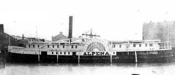
S.S. Alpena, photo from Wikimedia Commons

Over on Absolute Michigan we have a feature from the Archives of Michigan about two Michigan couples who were aboard the Titanic. I thought it would be interesting to see what the worst Michigan maritime disaster was. You might think it would be the immortalized Edmund Fitzgerald but with “only” 29, it’s down on the list. Or perhaps the tragic Carl D. Bradley in which 33 men perished, most from her home port of Rogers City.

It’s actually the sidewheel steamer S.S. Alpena. Michigan Shipwrecks says that this 197 foot Goodrich side wheel steamer was built in Marine City, Michigan in 1866. She was lost with about 80 crew & passengers in the “Big Blow” of 1880.

The Alpena left Grand Haven, Michigan bound for Chicago on Friday evening, October 15, 1880 at 9:30 PM. The weather was beautiful — Indian Summer like. But the barometer was indicating a storm was coming and storm signals were out. She was met on her southwest journey by the steamer Muskegon at about 1:00 AM and everything seemed normal.

At about 3:00 AM Saturday, October 16, 1880 the “worst gale in Lake Michigan recorded history” swept across the lake. The Alpena was seen at 6:00 AM, 7:00 AM and at 8:00 AM by the schooner Irish and by Captain George Boomsluiter of the barge City of Grand Haven about 35 miles off Kenosha, Wisconsin, laboring heavily in the high seas.

She was seen later by several other vessel captains –one of whom reported her lying on her side with one of her paddlewheels out of the water. Ten car loads of apples were stowed on her main deck and some speculate this cargo became unmanageable in the storm, shifted, and led to the capsizing.

…The weekly Holland City News reported on October 23: “The wreck is complete. She is broken into small fragments. The stern part of her hull lies near the harbor. The whole coast for 20 miles is strewn with the debris, freight, etc.” The largest piece to land near Holland was the piano, “it being barely able to float, our sailors concluded that she did not come very far. And the arrival of other heavy pieces of the wreck would seem to corroborate this.”

The wreck has never been found and you can read on for more. FYI, the Great Lakes Shipwreck database pegs the loss of life close to 100 and adds that the first indication that she was lost was when masses of wreckage began washing ashore along the coast near Manistee. It took several days for the magnitude of the disaster to be realized. Her paddlebox nameboard washed ashore at “Alpena Beach” in 1909, after a storm.

The largest loss of life in open water on the Great Lakes was 300 aboard the Lady Elgin that was rammed by the schooner Augusta in September of 1860 off Highwood, IL . An interesting note is that this shipwreck led to the requirement for sailing vessels to carry running lights. The Smithsonian relates that the worst shipwreck on the Great Lakes:

In terms of loss of life, hands down, that’s called the SS Eastland, which went down in the Chicago River on July 24, 1915. For whatever reason, the ship turned over onto its port side right there in the river. Passengers either wanted to see something in the river and they went to port side, or the engineer improperly ballasted the ship, or it wasn’t a stable ship to begin, but she flipped over right into the Chicago River, not terribly deep water maybe 20-30 feet, and killed 844 passengers and crew. It still remains the worst loss of life on any single shipwreck in the Great Lakes.

More shipwrecks on Michigan in Pictures.

Trash the Dress, Michigan

Trash the Dress

Trash the Dress, photo by Steven White Photographic Art

Wikipedia says that Trash the Dress is:

…also known as fearless bridal or rock the frock, is a style of wedding photography that contrasts elegant clothing with an environment in which it is out of place. It is generally shot in the style of fashion and glamour photography. “Trash the dress” is the art of destruction or deconstruction of a brides wedding dress to create a new “artwork” that the bride would be proud to display on their wall. This new “masterpiece” is formed in the creative destruction of the dress. This will normally be portrayed in a sequence of images or simply a single image…

It may be done as an additional shoot after the wedding, almost as a declaration that the wedding is done and the dress will not be used again. It is seen as an alternative to storing the dress away.

It’s also being used for prom dresses now. Check this out background bigtacular and in Steven’s Portraits slideshow and at stevenwhitephotographicart.com.

There’s a Trash the Dress group on Flickr and also check out the Trash the Dress Michigan slideshow on Flickr.

Grand Sable Lake in the Pictured Rocks National Lakeshore

Grand Sable Lake

Grand Sable Lake, photo by Gary of the North

The Michigan DNR says (in part from this PDF) that Grand Sable Lake:

…is a scenic undeveloped lake located in Alger County, about 6 miles southwest of Grand Marais. The 630 acre lake lies within the boundaries of the Pictured Rocks National Lakeshore (PRNL). The shoreline is mostly wooded with mixed hardwoods, conifers, and cedar species. Most of the surrounding soils are sandy. Sand dunes 200 ft high are located on the north end. Grand Sable Lake has a maximum depth of 85 feet, but averages around 35-40 feet. The banks drop off quite rapidly. Even so, the shoreline at the public access site on the northeast shoreline remains shallow for over 200 feet, dropping quickly into deep water…

Access to the lake before the area became part of the PRNL was from the small park on the north end. At that time, the park was managed by the village of Grand Marais. A 1949 fisheries survey documented the presence of rock bass, northern pike, yellow perch, smallmouth bass, white suckers, and minnow species. Past stocking efforts included rainbow trout, splake, smelt, smallmouth, largemouth, pike, bluegills, and lake trout.

It’s apparently 50% white suckers now – click through to read more. Also see the Grand Sable Loop at DW Hikes.

Check this out background big and check out some other views here and here. More in Gary’s Pictured Rocks National Lakeshore slideshow.

Much (much) more from the awesomely amazing Pictured Rocks National Lakeshore on Michigan in Pictures!

It’s playoff time in Hockeytown

Jimmy Howard

Jimmy Howard, photo by Seth Christie

The Detroit Red Wings open the 2012 NHL playoffs at 8 PM tomorrow night in Nashville. As the game preview on the Red Wings site shows, the two teams finished with just 2 points separating them. The Predators have Pekka Rinne, the NHL’s leader in wins in the net and home ice in the series. The Wings have Jimmy Howard, Pavel Datsyuk, Nicklas LidstromHenrik Zetterberg and 2004 and 2008 playoff series victories over Nashville with 2008 resulting in a little thing called Lord Stanley’s Cup. Should be a great series – get more in Five Things you need to know about the Detroit Red Wings on Absolute Michigan.

Seth shot this great shot of Jimmy Howard from his seat in row K after being kicked out from by the glass. He has a better plan next time that involves not wearing the away teams jersey to the game. Check it out bigger and in his short but sweet Detroit slideshow.

Much more Detroit Red Wings action on Michigan in Pictures.

We’ve got you covered

DSC02766_tonemapped

DSC02766_tonemapped, photo by ansonredford.

I thought I’d feature a photo from our Michigan Cover Photos Group. You can add pics to it if you want to have them featured on our Michigan in Pictures Facebook and also the Absolute Michigan Facebook.

Recently we featured Donald’s photo of one of the sculptures on the Wayne County Courthouse. This is one of four that depict Law, Commerce, Agriculture, and Mechanics. They were executed by sculptor J. Massey Rhind.

Check it out background bigtacular and see some more including an amazing HDR of the courrthouse in Donald’s slideshow.