Heikki Lunta alias Hank Snow alias the Guy Responsible for the Snow

Houghtons Heikki Lunta

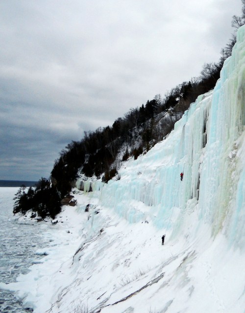
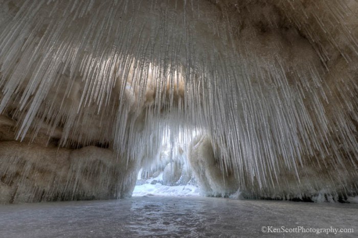
Hancock’s Heikki Lunta, photo by Mark Riutta / Defined Visuals

I know that many folks in southern Michigan are wondering where the heck all this snow came from. Last night I realized that a friend of mine was actually responsible!

Yooper Steez tells the Legend of Finnish snow god Heikki Lunta:

The name is now often associated with an annual winter festival in Negaunee, but it’s creation is linked to an annual snowmobile race held in Atlantic Mine. In 1970, the U.P. was having one of those winters where it doesn’t snow as much as we might like, which was threatening the success of the race. To increase support, radio salesman David Riutta wrote the “Heikki Lunta Snow Dance Song.” This song created the fictional Heikki Lunta as a creature that lived in the backwoods of Tapiola, twenty miles south of Houghton, and would perform a dance to make it snow. The song went on U.P. airwaves and was a success, and incidentally it did snow that year, causing the snowmobile race to be postponed on account of too much snow.

The song gained popularity enough to be mentioned on “The Today Show” and “The Tonight Show,” and the radio salesman was even invited to sing the song for winter events in California.

As anyone who has been through an Upper Peninsula winter knows, the snow can become relentless, and by the end of that winter, Riutta wrote “Heikki Lunta Go Away,” which is now often paired with the initial song.

The name Heikki Lunta comes from the Finnish translation of the name Hank Snow, like the popular country and western singer.

Read on for more including videos of the Heikki Lunta Song by Da Yoopers and also see Heikki Lunta – A Modern Copper Country Folk Hero at Pasty.com. If you want to go in depth, Hilary Virtanen presents a detailed and fascinating history of this distinctly Yooper phenomenon from 1970 to the present day with press clippings and more in Not Just Talking About the Weather: Tradition, Social Change and Heikki Lunta (use the dates on the left to navigate).

View Mark’s photo bigger and see his work at Defined Visuals on Facebook.

PS: When he’s not making it snow, Adam is also a fantastic photographer. See his work, some of which is potentially NSFW depending on where you work, at brockit.com.

2015 Michigan Ice Fest this weekend!

DSCN0507

Untitled, photo by Greg Maino

Every year at the beginning of February (Feb 5-8, 2015), ice climbing fans from all over descend on Munising for the Michigan Ice Festival. The weekend features presentations and instruction from some of the top climbers in the world, gear demos, climbing socials and the premier of the trailer for the Michigan Ice Film.

You can see some of the climbing locations (formed by frozen waterfalls and seepage) right here, and if you do head up and pack your camera, consider entering their 2015 Ice Fest photo contest.

View Greg’s photo background big. Most of the climbing is not this extreme – see more of it in his Icefest 2011 slideshow. Be sure to also check out his Icefest: Early Years slideshow and follow his adventures at juskuz.com.

Happy Groundhog Day, Michigan!

Michigan Groundhog
Young Groundhog, photo by John E Heintz Jr

Happy Groundhog Day everyone! We’re hoping that folks in the southern part of the state are digging out all right!

Michigan has native groundhogs, also known as woodchucks, whistle-pigs, or land-beavers. You can learn all about them from the University of Michigan Animal Diversity Web under Marmota monax (woodchuck) which says (in part):

Woodchucks have numerous common names, including ground hog, and whistle pig. The word “woodchuck” is a misinterpretation of their Native American name “wuchak”, which roughly translates as “the digger”. Groundhog Day occurs when Punxsutawney Phil, a captive woodchuck held in rural Pennsylvania, is awakened from hibernation in order to determine if he will see his shadow. According to the legend, if he sees his shadow there will be 6 additional weeks of winter. If he does not see his shadow, legend predicts an early spring.

The legend of Groundhog Day is likely due to the fact that woodchucks often re-enter hibernation after emerging from their dens prematurely.

We all know about Punxsutawney Phil, but have you heard of Michigan’s Official Groundhog? Her name is Woody, and she lives at the Howell Conference & Nature Center and unfortunately is battling a severe respiratory infection so her alternate Murray will stand in if she’s unable to perform her official duties at 8:15 today.

Woody correctly forecast six more weeks of winter weather on February 2, 2014, much to the chagrin of close to two hundred shivering attendees of that Sunday morning’s Groundhog Day festivities.

Last year’s prognostication, her sixteenth, was made crystal clear by her outright refusal to even leave her home. With temperatures at the Nature Center hovering in the low 20′s and several inches of snow on the ground, the clairvoyant chuck’s behavior was interpreted as just another sign of her wisdom.

Read on for more.

View John’s photo bigger and see lots more backyard wildlife in his ANIMAL PHOTOGRAPHY slideshow.

Blizzard beats boat: The Blizzard of ’78

Capsized and Ice Locked

Blizzard beats boat, photo by John Russell

Oh ice, I can’t stay mad at you, even when you misbehave like this.

Associated Press photographer John Russell shared this photo from January 29, 1978. He writes:

My office 37 years ago: Marty Lagina stands on the frozen pier at the Great Lakes Maritime Academy on January 29, 1978, viewing the capsized training vessel Allegheny, which capsized from ice buildup during the Blizzard of ’78. This image was on assignment for TIME magazine, who had seen my b&w image on the UPI wire and wanted a color image.

Marty and I were lucky – the sky cleared and the wind stopped for about 20 minutes, then the storm began again. I wondered at the time who TIME knew to make that happen….

The photo was taken in Traverse City, ground zero for the blizzard Seeking Michigan shared info about one of Michigan’s most significant winter storms:

On January 26-27, 1978, snowstorms with fifty-to-seventy-mile per hour winds pummeled much of Michigan. Snowfall totals ranged from eighteen inches in Lansing to an incredible fifty-one inches in Traverse City. More than 100,000 cars were abandoned on roads and highways, and travel was impossible for days. Governor William G. Milliken declared a state of emergency on January 26 and activated the National Guard to assist with the cleanup. The governor also requested financial assistance from the federal government and estimated damage totals to be more than $25 million, not including lost productivity from workers who were unable to get to their jobs.

Click through to view his photo bigger and friend John on Facebook – his “My Office” series is a great look at what’s happening all over Michigan.

PS: Sorry for all the pics from Leelanau/Traverse City lately. Sometimes it just works out that way…

North Bar Lake

North Bar Lake by Sarah Hunt

North Bar Lake, photo by Sarah Hunt

Who’s ready for a break from snow & ice? The Sleeping Bear Dunes National Lakeshore page on the North Bar Lake Overlook says (in part):

The name describes how the lake formed: it is ponded behind a sand bar. At times, the sand bar builds up and separates North Bar Lake from Lake Michigan. At other times, a small connecting channel exists between the two lakes. North Bar Lake occupies part of a former bay on Lake Michigan. This ancient bay was flanked by headlands on both sides: Empire Bluffs on the south and Sleeping Bear Bluffs on the north. Shorelines have a natural tendency to become straighter with time. Wave action focuses on the headlands and wears them back, while shoreline currents carry sediment to the quiet bays and fill them in. Deeper parts of the bay are often left as lakes when sand fills in the shallower parts.

The same process that formed North Bar Lake also formed many of the other lakes in northern Michigan: Glen, Crystal, Elk and Torch Lakes, for example.

Here’s more about the geology of the Sleeping Bear and more about North Bar Lake, to which I’d add that the lake is a great place for skim boards because the channel between North Bar & Lake Michigan is only a few inches deep!

Sarah took this photo last summer. Click it to view background bigalicious and check out lots more of her incredible and adventurous photography at instagram.com/oni_one_.

PS: If you’re still not full-up on winter and ice, might I suggest this pic she took in this area of Sleeping Bear last week!

#TBT The Ice Caves of Leelanau from Ken Scott

Ken Scott Ice Cave

Lake Michigan … crystal cave II, photo by Ken Scott Photography

“My creative eye is always on. It doesn’t get bored. A lot of people get stuck on seeing things only one way, like the wide view or closeup view … but there’s everything in between. Boredom would come when you’re getting stuck in seeing things only one way. You just have to shift it a little bit and it can open up a whole other world.”
~Ken Scott

Kudos to Michigan in Pictures regular Ken Scott, whose photography of last winter’s ice caves on Lake Michigan is featured in the Huffington Post today. They write:

Scott’s documentation of the ice caves last year on Facebook drew likes, attention and, eventually, the book deal. In Ice Caves of Leelanau, he shows numerous views of the caves, blue ice, volcano ice, pancake ice, the large sheet of anchor ice along the shore, and the rounded and smoothed chunks of ice known as ice balls. Meteorologist Ernie Ostuno captioned Scott’s photographs for the book, and nature writer Jerry Dennis introduced them:

The caves were the surprising thing. Many of us had seen similar structures during other winters, but never many of them, and never this large. These were big enough to stand in — for a dozen people to stand in — and as elaborate as caves in limestone. They were domes and keyholes and grottos. Wave spray and intermittent thawing and freezing had embellished them with columns and pillars. Their surfaces were so smooth they gleamed in sunlight, and from their ceilings dripped hundreds of daggers of clear ice, like crystal stalactites.

George Leshkevich, a researcher with the North American Ocean Administration’s Great Lakes Environmental Research Laboratory, noted that last winter was particularly severe for the Great Lakes, resulting in unique conditions where ice reached peak thickness two separate times in the season.

Different kinds of ice formations occur because of a confluence of reasons, Leshkevich explained, including meteorological conditions, the physical location and wave action, so they’re hard to predict and will vary widely along the shore.

Click through for more great photos. You can check out a short video or a long one from this particular formation, and definitely get a copy of Ice Caves of Leelanau if you can!

PS: I hope all this ice caveyness isn’t bothering you – I’m so happy to see Michigan getting some wintertime love.

Halo, Sundog & Circumzenithal Arc over Marquette

Solar Halo over Marquette Lighthouse

Welcome to the Smile High Club, photo by Lake Superior Photo

Today’s photo is one of the most incredible pictures I’ve seen. In addition to the Marquette Harbor Light and the frozen Superior shore, there’s a cornucopia of solar optics that fairly defies imagination.

Atmospheric Optics is a wonderful website, certainly the best I’ve found for describing solar phenomena in a clear and inspiring manner. Here’s a bit of decoding of what’s happening in the skies of Marquette yesterday, but definitely follow the links to explore. There’s so much information and some great photos too!

First, above the lighthouse, there’s a 22º radius halo:

…visible all over the world and throughout the year. Look out for them (eye care!) whenever the sky is wisped or hazed with thin cirrus clouds. These clouds are cold and contain ice crystals in even the hottest climes.

The halo is large. Stretch out the fingers of your hand at arms length. The tips of the thumb and little finger then subtend roughly 20°. Place your thumb over the the sun and the halo will be near the little finger tip.

The halo is always the same diameter regardless of its position in the sky. Sometimes only parts of the complete circle are visible.

There’s also a sundog, known also as parhelia or mock sun. These appear in the 22º halo, even when you can’t see the halo. You can see one at the visible base of the halo on the right:

They are most easily seen when the sun is low. Look about 22° (outstretched hand at arm’s length) to its left and right and at the same height. When the sun is higher they are further away. Each ‘dog’ is red coloured towards the sun and sometimes has greens and blues beyond. Sundogs can be blindingly bright, at other times they are a mere coloured smudge on the sky.

They advise you’ll see one or two a week if you look and if you click over you can learn about how they form & moon dogs.

Finally, we come to the circumzenithal arc (CZA), the upside down rainbow at the top:

…the most beautiful of all the halos. The first sighting is always a surprise, an ethereal rainbow fled from its watery origins and wrapped improbably about the zenith. It is often described as an “upside down rainbow” by first timers. Someone also charmingly likened it to “a grin in the sky”.

Look straight up near to the zenith when the sun if fairly low and especially if sundogs are visible. The centre of the bow always sunwards and red is on the outside.

The CZA is never a complete circle around the zenith, that is the exceptionally rare and only recently photographed Kern arc.

Read on for more, and definitely be sure to check atoptics.co.uk when you see solar & lunar phenonmena you’d like to know more about.

View Shawn’s photo bigger and join thousands of others in following Lake Superior Photo on Facebook … and on the Twitters. You can purchase this photo on the Lake Superior Photo website.

PS: Check out Dominic B. Davis’s photo of the solar halo in the morning too!

Like beauty, danger is all around you

Laura getting the shot

Laura getting the shot, photo by Andrew McFarlane

“A ship is safe in harbor, but that’s not what ships are for.”
~William G. T. Shedd

Every so often I have to write a post to clarify what Michigan in Pictures is or is not, and I guess that today is one of those days.

Sunday morning, I posted this photo (also at the bottom of this post) to the Michigan in Pictures Facebook page with the very accurate caption “We went out to Good Harbor Bay on Lake Michigan yesterday to play on the ice!” As you can see from the photo, Laura is positioned well back from the edge. While perhaps not perfectly safe, she is far safer than she was driving to the beach.

Several readers took issue with the idea that it’s appropriate to “play” in a potentially hazardous environment like shelf ice on Lake Michigan, suggesting that it’s irresponsible for me to share photos from risky environments, that I not do it, and that I focus on providing precautionary education encouraging people to make safe decisions. I replied (in part):

Shelf ice is indeed dangerous if you don’t know where you are and what you’re doing. The water where we were is 3′ deep in summer and the ice very solid, so in my opinion, play is exactly what it was.

Your concern for safety is good, but if you take proper precautions, you’re a heck of a lot safer here than driving on a winter road.

I post pictures all the time where the photographers have taken calculated risks to see, photograph and experience things that you cannot see and photograph without an element of risk. I allow my son to surf in conditions that can be very dangerous, let my daughter climb trees high enough to probably kill her if she fell, and hiked on trails where one slip meant death.

I suppose I should post disclaimers of “don’t be an idiot” with all photos of risky environments, but I think I will continue to assume that my readers will assess risks on their own, and I will continue to experience and share Michigan as I choose.

…Please understand that Michigan in Pictures is a place where I share amazing pictures that are shared with me. I’m not doing this as a public service to educate people on how to stay alive and safe. I do it for love of Michigan and to share the cool experiences it offers. I trust that my readers will exercise appropriate caution as they enjoy Michigan, and I’m 1000% sure that if folks get out and wisely play a little closer to the edge, they’ll have a happier and longer life.

Caveat emptor!

Caveat emptor will remain the policy of Michigan in Pictures, which I will again remind readers is my personal blog, not paid for by anyone and offered with the sole hope that you can find pictures and places that help you enjoy and appreciate Michigan more.

View my photo background big and see more on our mileelanau Instagram.

PS: Thanks to Kate Wittenberg for the perfect William G. T. Shedd quotation that she shared in the comments!

PPS: Here’s the photo Laura shot. Position, framing, tone.

Lauras Photo

Happy 178th Birthday to you, Michigan!

Michigan Sign at State Line 1958

Michigan Sign at State Line 1958, photo by Seeking Michigan

Today is Statehood Day, Michigan’s 178th birthday. For Michigan’s 175th birthday in 2012 I put together some fun facts about Michigan. They’re still true and still fun!

  • Michigan is derived from the Indian word Michigama, meaning great or large lake. (more about Michigan’s name on Michigan in Pictures)
  • French explorers Étienne Brulé & Grenoble are the first recorded Europeans to set foot in Michigan (you never know though). In 1668 Fathers Jacques Marquette and Claude Dablon established the first mission at Sault Ste. Marie, and in 1701, French officer Antoine de la Mothe Cadillac founded  Fort Pontchartrain in Detroit.
  • The Michigan Territory was created, with Detroit designated as the seat of government and William Hull appointed as our first governor.
  • Michigan became the 26th state on the 26th of January, 1837. Is 26 our lucky number? FYI, our first State governor was Stevens T. Mason, the 25 year old Boy Governor (the youngest state governor in American history).
  • Michigan’s nickname is “the Wolverine State”. It is generally believed to have been coined during the 1835 Toledo War between Michigan and Ohio, when our southern rivals gave us the name due to the wolverine’s reputation for sheer orneriness!
  • The Great Seal of Michigan was designed by Lewis Cass and was patterned after the seal of the Hudson Bay Fur Company. It depicts an elk on the left and a moose on the right supporting a shield that reads Tuebor (“I will protect”).The interior of the shield shows a figure on the shore with the sun rising over a lake. His right hand is raised, symbolizing peace, but he holds a rifle in his left hand, showing readiness to defend the state and nation.Below the shield is the inscription of our state motto Si quaeris peninsulam amoenam circumspice: “If you seek a pleasant peninsula, look about you.” (I just learned that Michigan has an Office of the Great Seal – how cool would it be to say you worked there??)
  • The original State Capitol of Michigan was Detroit, and it moved to Lansing in 1847 to help develop the western side of the state and due to the need to develop the western portions of the state and for easy defense from British troops. Here’s apic of Michigan’s original Capitol Building and an 1890s view of the current Michigan capitol.
  • Michigan is the 10th largest state by area if you count the water … and who wouldn’t count the water??
  • Speaking of water, we have 3,288 miles of Great Lakes shoreline, good for second to only Alaska in coastline!

View the photo background big and see more in their Tourism slideshow.

More of Michigan’s birthday on Michigan in Pictures.


Winter Tannins – Tahquamenon Falls

Winter Tannins - Tahquamenon Falls (Tahquamenon Falls State Park - Upper Michigan)

Winter Tannins – Tahquamenon Falls, photo by Aaron C. Jors

Wikipedia’s entry on the Tahquamenon River explains that because the headwaters of the river are located in a boreal wetland that is rich in cedar, spruce and hemlock trees, the river’s waters carry a significant amount of tannin in solution  and are often brown or golden-brown in color. The Tahquamenon Falls are thus the largest naturally dyed or colored waterfall in the United States

View Aaron’s photo from January 1st bigger and see more in his Michigan slideshow.

Lots more about the Tahquamenon Falls on Michigan in Pictures.

Get out there and see something amazing this weekend!!