Kayaking to Turnip Rock

Kayak at Turnip Rock

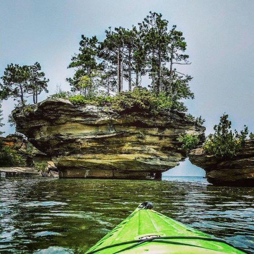
Turnip Rock, Port Austin, MI, photo by Seasons Photography

The second in our series of “Cool Places Your Kayak Can Take You” features this cool rock formation in Lake Huron. Port Austin Kayak’s page on kayaking to Turnip Rock says:

A trip to Turnip Rock in Port Austin is unmistakably one of the best activities for kayakers on Lake Huron. The trip consists of a 7 mile out-and-back trip via the Point aux Barques trail. The shallow waters surrounding Turnip Rock allow you to get out and enjoy the area as well as snap a few photos while you are there. Be sure to wear suitable footwear if you are going to exit the kayak as the rocks are slippery. For an account of what it’s like kayaking out to Turnip Rock, read this adventurer’s great story. While this story also goes out to the lighthouse, that leg of the trip is for experienced kayakers only and is reserved for the calmest weather days, as you will be kayaking two miles out into Lake Huron.

Please note that the property surrounding Turnip Rock is privately owned, which is why kayaking is the premier way to access the rock. The owners of the surrounding properties take great care of the land and we ask that you respect their space by not trespassing or littering.

If you don’t have a kayak, they can certainly rent you one. That link goes to one of my favorite photographer’s trips: Lars Jensen and his Turnip Rock expedition.

View the photo bigger and see more in Seasons Photography’s Michigan slideshow.

More kayaks & kayaking and more about Turnip Rock on Michigan in Pictures.

Soo Locks, Sault Ste. Marie Michigan

Sunset at the Soo Locks

Sunset | Soo Locks, photo by Camaeleo

While I’ve shared numerous photos from the Soo Locks, I’ve never provided the history of one of Michigan’s defining marvels. The Sault Ste. Marie Convention & Visitors Bureau has a brief Soo Locks history:

In 1797, the Northwest Fur Company constructed a navigation lock 38 feet long on the Canadian side of the river for small boats. This lock remained in use until destroyed in the War of 1812. Freight and boats were again portaged around the rapids.

Congress passed an act in 1852 granting 750,000 acres of public land to the State of Michigan as compensation to the company that would build a lock permitting waterborne commerce between Lake Superior and the other Great Lakes. The Fairbanks Scale Company, which had extensive mining interests in the Upper Penninsula, undertook this challenging construction project in 1853.

In spite of adverse conditions, Fairbanks’ aggressive accountant, Charles T. Harvey, completed a system of two locks, in tandem, each 350 feet long, within the 2 year deadline set by the State of Michigan. On May 31, 1855, the locks were turned over to the state and designated as the State Lock.

The federal government took control of the property and the lock system in the 1870’s. Their stewardship continues today, administered by the U.S. Army Corps of Engineers. The Soo Locks are the busiest locks in the world, and include the largest lock in the Western Hemisphere, completed in 1968.

You can click through for some more information and pictures, but definitely head over to the Detroit Army Corps of Engineers Soo Locks History page for a timeline of all the locks that have been built. You can also get an animated demo of how the locks work and look in on the locks via the Soo Locks Webcams.

View Camaeleo’s photo bigger and see more in their Sault Ste. Marie slideshow.

Shipwreck Saturday: The Wreck of the Minnehaha

Taking on Water

Taking on Water, photo by Aaron Springer

“She was built in 1880 [by Linn & Craig in Gibralter, Michigan] and has been unfortunate from the start. Two years ago [in 1891] she was wrecked near Detour [at the north end of Lake Huron], and remained on the rocks all winter, being abandoned to the underwriters, who finally rescued the wreck and sold it.”
~ Buffalo Evening News Monday, October 16, 1893

Historic Arcadia Michigan tells the tale of The Wreck of the Minnehaha:

In October of 1893, the steam barge Henry J. Johnson was towing the Minnehaha from Chicago bound for Point Edward at the south end of Lake Huron with 58,000 bushels of corn. At 7:30 PM on October 13, the two ships found themselves off Point Betsie facing 90 mile per hour gale force winds. They tried to find shelter behind the Manitou Islands, but at dawn the next day, they were still south of Sleeping Bear Point fighting high winds and waves to stay out of shallow water.

Captain Benniteau of the Johnson decided to turn the ships south and head to Frankfort, the nearest refuge. However, somewhere near Frankfort high waves crashed over the Minnehaha’s deck, smashed two hatch covers, and began filling the hold with water. William Parker, captain of the Minnehaha, realizing his ship was in serious trouble, sent up distress signals, released the tow lines, and headed for the beach. There was nothing the crew of the Johnson could do but avoid the same shallow water.

The Minnehaha ran aground about a quarter of a mile offshore between Burnham and Arcadia. To avoid the waves sweeping the decks, all but one member of the crew, who drowned trying to swim to shore, climbed into the ship’s rigging. As the ship was breaking up, the captain called to the crew to grab whatever would float and go over the side anyway. But only the captain made it to shore safely. One crew member made it to a pier, but was too tired to hold onto a pole used to try to pull him to safety.

Read on for much more including photos of the Minnehaha.

Check out Aaron’s photo bigger where he also has a pic of the wreck in calm water and see many more of his great photos of Lake Michigan.

More Michigan shipwrecks on Michigan in Pictures!

The Badger steams on

S.S. Badger - Ludington Mi.

S.S. Badger – Ludington Mi., photo by RJE

NPR has a feature on the upgrades to the SS Badger that allow the car ferry to continue to operate between Michigan and Wisconsin on Lake Michigan:

A slice of history sails across Lake Michigan, carrying cars between Ludington, Mich., and Manitowoc, Wis. It’s the SS Badger: the largest coal-fired passenger ship still operating in the United States.

For years, the ship was the focus of environmental scrutiny because of its practice of dumping waste coal ash directly into the lake. The pollution nearly stopped the Badger from steaming again — but now, the ash-dumping has ended.

…After decades of letting the Badger pollute the lake, the Environmental Protection Agency issued an ultimatum: Stop dumping or be grounded.

Finally, this off-season, the boat’s owner installed a $2 million solution: a set of blue pipes that collect ash each trip, about 500 tons per year. Once a week, that ash gets trucked to Charlevoix, Mich., for use in making cement products.

You can get all the info on the Badger right here. For an added dose of awesome in your day, check out The Steamer 43 Song by Pete Host, featuring photos of the SS Badger on Absolute Michigan. It’s from a 45 Pete recorded in the early 70s about a sailors life on the C&O carferries out of Ludington, Michigan. With his spare time aboard the Badger, he learned how to play the guitar, and in just a few months, went to Milwaukee Wis. and recorded this song.

View the photo bigger and see a couple more of R.J.E.’s photos of Ludington, Michigan.

More Michigan ships and boats on Michigan in Pictures.

Copper Harbor Sunset

Copper Harbor Sunset by John McCormick

Copper Harbor Sunset, photo by John McCormick

John says this is one of his favorite shots from last year. Click to view it bigger, follow him on Facebook and visit MichiganNutPhotography.com to view and purchase this and other pics.

Coast Guard shares Manitou Passage shipwrecks from above

Wreckage of the Rising Sun

Wreckage of the Rising Sun, photo by U.S. Coast Guard Air Station Traverse City

Yesterday the U.S. Coast Guard Air Station Traverse City shared a collection of photos from the Manitou Passage Underwater Preserve, writing”

We can call it “Shipwreck Sunday” – With Lake Michigan ice gone for the season the crystal clear, deep blue waters of northern Michigan are back (albeit still VERY VERY cold at an average of 38 degrees).

During a routine patrol this past Friday, an aircrew captured these photos of a handful of the many shipwrecks along the Lake Michigan shoreline. These photos were taken near Sleeping Bear Point northeast along the shoreline to Leland, Michigan up to Northport.

Information on the shipwrecks is scarce, please post if you recognize any of the photographed sites.

View the Coast Guard’s photo bigger and click through for photos of other wrecks including the James McBride. Definitely follow them on Facebook for more cool shots of Michigan’s coastline from above!

Regarding the Rising Sun, the Leelanau Enterprise shares Leelanau historian George Weeks account of the wreck that includes a photo of the grounded Sun:

In October 1917, the Rising Sun went to High Island to get potatoes, rutabagas and lumber to take to Benton Harbor. On 29 October, in one of the early-season snowstorms that sweep the Lakes, the Rising Sun went aground at Pyramid Point. Lifeboats were launched and all thirty-two people aboard eventually saved.

As was often the case with Great Lakes wrecks, shoreline residents, not the U.S. Coast Guard, were the first to provide assistance. In this case, Fred Baker, summoned in the night by survivors pounding at the door of his home atop the Port Oneida bluff, was the first to respond. He hastened to his barn, quickly unloaded 60 bushels of potatoes that were on his wagon, hitched his team, and went down to the beach. The survivors, including a woman found unconscious on the beach, were brought to Baker’s house. (By the 1990s, Baker’s daughter, Lucille, who was four years old at the time of the wreck, was still residing at Port Oneida, the wife of Jack Barratt, great grandson of Port Oneida settler Carsten Burfiend.)

The Coast Guard beach rescue rig arrived from Glen Haven, pulled by two teams of horses borrowed from D.H. Day. A man who was asleep when the others abandoned ship was rescued by the guardsmen.

Remains of the Rising Sun are visible from the shore on a clear day, and are popular for recreational divers. As with other wrecks, the remains are protected objects within the Manitou Passage Bottomland Preserve.

Read more about the Rising Sun, it’s caro and final voyage and the House of David that owned it from Chris Mills and see more shipwrecks on Michigan in Pictures.

Ice bound, Whitefish Bay

Ice bound, Whitefish Bay

Ice bound, Whitefish Bay, photo by Thom Skelding

Here’s a cool shot from last Saturday on Lake Superior’s Whitefish Bay. I hope that you’re shaking off the ice and getting out to enjoy whatever spring is serving up close to you.

View Thom’s photo background big and see more great shots from Whitefish Bay and elsewhere in his slideshow.

Standing Iceboater

Ice Boating in Leelanau County Michigan

Standing Iceboater, photo by Mark Smith

It’s 8 degrees right now in Traverse City, and while the weeklong run of wintry weather hasn’t been good for such popular pursuits as getting the garden ready, boxing up winter clothes and keeping your house from being declared a Cabin Fever Disaster Area, it has left the ice in many parts of the state just perfect for the sport of ice boating.

Northern Michigan AP News photographer John Russell is a Michigan in Pictures contributor and wrote Ice Boating: An Ancient Sport in a Modern World a few years ago. It begins:

Sailing on frozen surfaces is believed to have its roots in Northern Europe, where goods and people moved around the region on frozen rivers and canals, using simple sails and handmade boats.

The Dutch and others brought iceboating to the Hudson River valley and other places along the East Coast, where miles of frozen rivers made for great sailing during the winter months. Freight and people were commonly moved up and down the Hudson River in huge, slooped-rigged boats.

Ranging in length from 30 – 50 feet, the stern-steering boats are still raced today by the Northwest Ice Yacht Association, having recently celebrated its 100th anniversary.

The ancient sport of sailing on frozen lakes and rivers is alive and well in our state, which has a long and involved history in the sport. Innovations developed in Michigan have enhanced and improved iceboating.

During the winter of 1936-1937, in the hobby shop at the Detroit News, boat builder Archie Arroll, along with Norm Jarrait and Joe Lodge, designed an ice boat they called the Blue Streak 60. Designed to be small enough to build in a garage, and easy enough to be built by anyone, the 12-foot hull design became known as the DN 60, for Detroit News and the 60-square-foot sail.

It is now the largest one-design boat class in the world, with over 8,000 registered boats around the world.

Read on for more including our state’s role in international ice boat racing, some state clubs, safety tips and a couple of photos from John.

Mark took this shot earlier in the week on Lake Leelanau. View it background bigtacular and see more photos (and a couple videos) in his Ice Boats slideshow.

More Michigan iceboating on Michigan in Pictures!

Blizzard beats boat: The Blizzard of ’78

Capsized and Ice Locked

Blizzard beats boat, photo by John Russell

Oh ice, I can’t stay mad at you, even when you misbehave like this.

Associated Press photographer John Russell shared this photo from January 29, 1978. He writes:

My office 37 years ago: Marty Lagina stands on the frozen pier at the Great Lakes Maritime Academy on January 29, 1978, viewing the capsized training vessel Allegheny, which capsized from ice buildup during the Blizzard of ’78. This image was on assignment for TIME magazine, who had seen my b&w image on the UPI wire and wanted a color image.

Marty and I were lucky – the sky cleared and the wind stopped for about 20 minutes, then the storm began again. I wondered at the time who TIME knew to make that happen….

The photo was taken in Traverse City, ground zero for the blizzard Seeking Michigan shared info about one of Michigan’s most significant winter storms:

On January 26-27, 1978, snowstorms with fifty-to-seventy-mile per hour winds pummeled much of Michigan. Snowfall totals ranged from eighteen inches in Lansing to an incredible fifty-one inches in Traverse City. More than 100,000 cars were abandoned on roads and highways, and travel was impossible for days. Governor William G. Milliken declared a state of emergency on January 26 and activated the National Guard to assist with the cleanup. The governor also requested financial assistance from the federal government and estimated damage totals to be more than $25 million, not including lost productivity from workers who were unable to get to their jobs.

Click through to view his photo bigger and friend John on Facebook – his “My Office” series is a great look at what’s happening all over Michigan.

PS: Sorry for all the pics from Leelanau/Traverse City lately. Sometimes it just works out that way…

Icebreaking on the St Mary’s River is an international effort

Icebreaking on the St Marys River

Icebreaking on the St Mary’s River, photo by U.S. Coast Guard Air Station Traverse City

Here’s an aerial shot of the 228-foot Canadian Coast Guard Ship (CCGS) SAMUEL RISLEY working in partnership with U.S. Coast Guard’s Sault Ste. Marie Sector on icebreaking operations in the St. Mary’s River last weekend. They write:

USCG Sector Sault Ste. Marie is also in high gear kicking off the 2015 Operation Taconite season, as ice continues to build daily across the Great Lakes. US Coast Guard and Canadian Coast Guard icebreakers are conducting around the clock icebreaking operations to assist commercial vessel traffic in the connecting waterways of Lake Superior, Lake Michigan, and Lake Huron.

Operation Taconite is the largest domestic icebreaking operation in the US. Over water shipping offers the only effective means of transporting the vast amounts of iron ore from the mines at the Head of the Lakes in Minnesota needed to meet the demands of steel mills in Lake Erie and Lake Michigan. Operation Taconite is primarily responsible for ensuring the successful transport of this cargo amid the harsh winter conditions of the northern Great Lakes.

Air Station MH-65s routinely fly ice reconnaissance flights in support of the operation

The photo was taken by the crew of one of the Traverse City Coast Guard Air Station’s Dolphin helicopters. View it background bigtacular and click through for a shot of the USCG Icebreaker Mackinaw working to keep this vital shipping channel open.

There’s more winter wallpaper and more ships on Michigan in Pictures.