

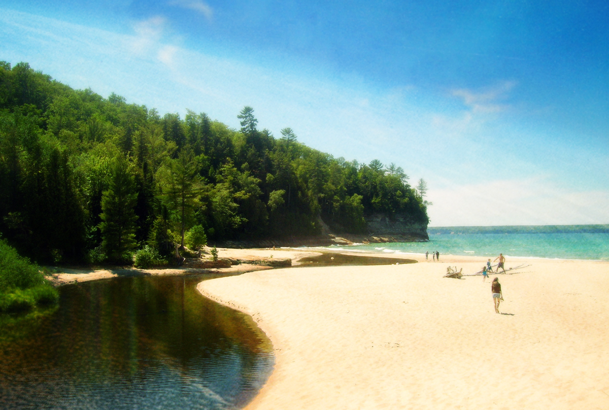
Summer Dreams, photo by Miss Sydney Marie
Anyone else dreaming of summer?
View Sydney’s photo bigger and see more in her For Sale slideshow and on her website.
Summer Dreams, photo by Miss Sydney Marie
Anyone else dreaming of summer?
View Sydney’s photo bigger and see more in her For Sale slideshow and on her website.
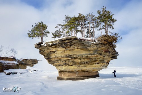
“Turnip Rock” Pointe Aux Barques, Lake Huron, photo by Michigan Nut
Michigan’s Little Finger has been getting a lot of national media attention for the fantastic ice caves that have formed off the Leelanau Peninsula, but it’s a good time to check out the Thumb as well! Turnip Rock is on private property and reachable in the summer only by boat. In wintertime, however, walking on publicly owned Lake Huron becomes an option.
The Point Aux Barques – Turnip Rock geocache explains:
Everyone that received their grade school education in Michigan learned that glaciers pushed their way over Michigan several times. The result is glacial drift averaging 200 to 300 feet deep covering on top of the bedrock. The thickness of drift has measured over 1,000 feet in a few Michigan locations. Rarely can we see exposed bedrock that has been sculptured by non glacier forces. This is one of the locations in southern Michigan where the sandstone bedrock is exposed at the surface. The amount of shoreline that has exposed sandstone is about one mile, but a lot of beauty has been sculptured in the stone.
The locals call the main structure here “Turnip Rock”, because of it’s shape. Geologists call it a “Sea Stack”. A definition of a sea stack is an isolated pillar-like rocky island or mass near a cliff shore, detached from a headland by wave erosion assisted by weathering. Waves force air and small pieces of rock into small cracks, future opening them. The cracks then gradually get larger and turn into a small cave. When the cave wears through the headland, an arch forms. Further erosion causes the arch to collapse. This causes a pillar of hard rock standing away from the coast. Generally occurring in sedimentary rocks, sea stacks can occur in any rock type.
Here’s a map to Turnip Rock.
View John’s photo bigger and see more including nearby Point Aux Barques Lighthouse in his Lake Huron slideshow.
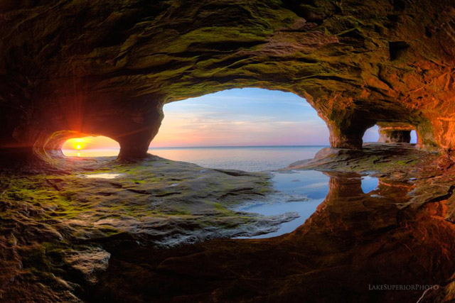
Paradise is the nickname of this place by Shawn Malone
Shawn says she crawled into this cave on Lake Superior when it was warm this summer.
View it bigger on Facebook and see more of her work at Lake Superior Photo … but don’t bother asking her where it is because she’s not telling … or me, because I don’t know!
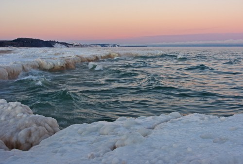
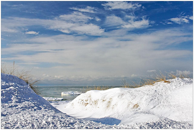
Winter morning on Agate Beach, photo by Gary of the North(Footsore Fotography)
Ernest W. Marshall talks about a common winter feature along considerable stretches of Great Lakes shorelines, the Icefoot:
Air and water temperatures must be sufficiently low before an icefoot begins to form. The conditions favorable for icefoot formation are broad open shorelines gradually sloping below water level, and facing so that wind-blown spray is carried inland toward the shore to freeze. The character of growth of an icefoot differs during different periods of the winter. During the course of the winter the icefoot may suffer periods of denudation alternating with periods of accretion. The development of an icefoot can be held at one stage by the early freezing of fast ice offshore. An icefoot can be composed of any combination of frozen spray or lake water, snow accumulations, brash, stranded icefloes, and sand which is either thrown up on the icefoot by wave action or is blown out from the exposed beaches.
Observations of the icefoot along the shorelines of Lakes Superior and Erie indicated that the moderately steep portions of the shore were characterized by narrow terraces composed of frozen slush and brash thrown up by storm winds. The outer edge of this icefoot was often cusp-like in form, resulting from the mechanical and melting action of the waves. The inner portions of the cusps acted to concentrate the wave action, forming blowholes which threw spray back on the icefoot.
You can click to read more.
Gary took this photo at one of my favorite places in Michigan: Agate Beach on Lake Superior in Grand Marais, Michigan. In the distance is Grand Sable Dunes and the Pictured Rocks National Lakeshore. View his photo big as Lake Superior and see more in his Grand Marais Michigan slideshow including a shot of a staggeringly huge ice mound!
Lots more Grand Sable Dunes, Pictured Rocks National Lakeshore & winter wallpaper on Michigan in Pictures!
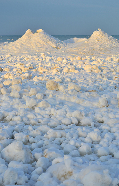
Lake Michigan … ice balls III, photo by Ken Scott
You may recall the Lake Michigan ice balls that were seen at the Sleeping Bear Dunes lakeshore last March. Well, they’re baaaaack. You can see a great video of the ball ice at Accuweather. Here’s the explanation of how balls ice form that I put together from AIR PHOTO INTERPRETATION OF GREAT LAKES ICE FEATURES by Ernest W. Marshal & Frazil ice at Wikipedia:
Ball ice consists of roughly spherical masses of slush and frazil ice that accrete in turbulent water. Frazil ice is a collection of loose, randomly oriented needle-shaped ice crystals that form in open, turbulent, supercooled water. Lumps that form in the less turbulent zones are typically flattened discs, while those formed in the extremely turbulent zone near the shoreline ice where wave action is strongest form into spheres.
The author explains that ball ice is a feature common to all of the Great Lakes and can occur at any time during the winter where water turbulence breaks up a slush layer. You can read more about this in Great Lakes Ice Features.
View Ken’s photo bigger, check them out in his ice balls slideshow and see this shot with Ken in it for a sense of the scale.
Pure Relaxation, photo by Jessie Eileen
We interrupt this winter to bring you a special announcement from summer:
“What good is the warmth of summer, without the cold of winter to give it sweetness.”
~John Steinbeck
View Jessie’s photo of Miner’s Beach at the Pictured Rocks National Lakeshore background big and see more in her dreamy Upper Peninsula: Summer 2006 slideshow.
More summer & summer wallpaper on Michigan in Pictures
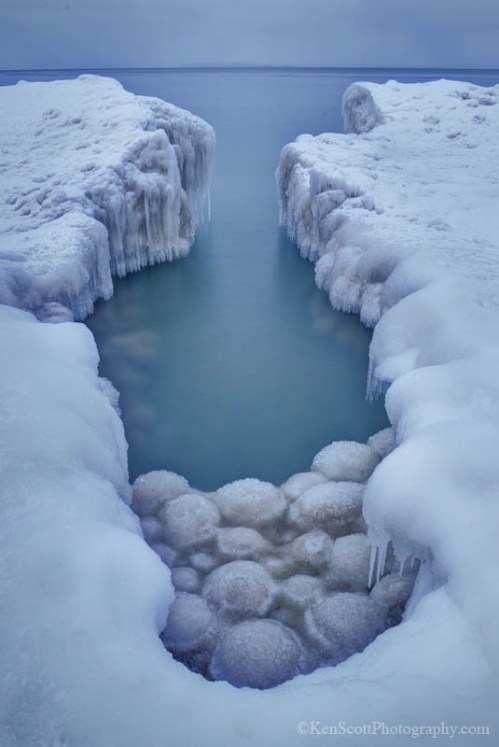
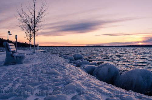
Shore Ice, photo by timmerschester
The Weather Notebook has this to say about Ice Volcanoes:
Ice volcanoes can form during winter on the Great Lakes. They are not lava-spewing mountains of ice, but water-spouting ice cones.
As winter ice begins to build along the shores of large lakes such as Lake Superior, it is jostled, broken, and shifted by the winds and wave motions on the waters. When winds blow onshore, they can build an ice shelf, a jumble of ice chunks that anchors on the shore but extends some distance back into the water. Amongst the numerous ice blocks comprising a shelf, many open tunnels lead back to the lake waters.
To build a good ice volcano cone, the surface air temperature must be several degrees below freezing and lake waves should be several feet high and breaking onshore. As the waves strike the edge of the ice shelf, pulses of wave energy flow beneath the ice. Upon reaching the open end of a tunnel, the wave forces water to erupt out through the ice. If the hole has been covered with snow, the eruption may spray snow outward like a volcanic gas cloud.
As the ejected water falls back onto the ice, it quickly freezes and begins the formation of an ice cone, a process very similar to the building of a lava cone surrounding a geologic volcanic vent. A study of ice volcanoes on Lake Superior’s southern shore by students from Michigan Tech measured ice cones ranging from three to 25 feet in height.
Like rock volcanoes, ice volcano vents can heal over and become dormant during periods of low wave action. They lie in wait for a strong wave surge to awaken them back to explosive activity.
Also see the Ice Volcanoes page from Michigan Tech and a video of an ice volcano from Great Lakes Echo.
Kathy took this photo on November 29th on Lake Huron in Caseville – pretty early for ice this big! Check it out background bigtacular and see more in her Winter slideshow.
More icy goodness on Michigan in Pictures.
Icy Alden Marina, photo by HLHigham
The winds are howling right now in Traverse City with the wind chill around 20 degrees. A scan of the state via Michigan-based Weather Underground shows that we’re at the top end with temps like 28 in Marquette, 21 in Grand Rapids & Detroit, 19 in Ann Arbor and 20 in Lansing along with wind chills in the low teens.
Although you might now believe it from this bench, Wunderground founder Dr. Jeff Masters writes that October 2013 was the 7th warmest October on record since 1880, the 344th consecutive month with global temperatures warmer than the 20th century average. The month also saw three $1 billion dollar weather disasters.
View Heather’s photo background big and see more in her Torch Lake slideshow.
More winter wallpaper on Michigan in Pictures!
Lake Effect 4794-09, photo by StacyN – MichiganMoments
Many in Michigan are waking up to frigid temps, high wind and snow – the perfect conditions for lake effect snow. Meteorologist Robert J. Ruhf has an excellent article on Lake-Effect Precipitation in Michigan that explains lake effect snow and rain are common in Michigan, especially in late fall and early winter as cold polar air moves across the warmer Great Lakes.
The unfrozen waters are relatively warm when compared with the temperature of the wintertime air mass. Therefore, the temperature of the air that comes into contact with the water increases. The warmed air expands and become less dense, which causes it to rise. This is an “unstable” situation. As the air rises, the temperature decreases until it reaches the dew point, which is the temperature at which the air becomes saturated.. Ice crystals or water droplets will then begin to collect until the force of gravity pulls them down. The result is “lake-effect” precipitation. When the cP air mass is very cold, as is often the case between December and February, the precipitation falls as snow. During late autumn, however, the polar air mass may be warm enough for the precipitation to fall in the form of rain.
“Lake-effect” precipitation can cause substantial intensification of snowfall amounts in very narrow bands, often referred to as “snow belts,” along the leeward (downwind) shores of the Great Lakes. The prevailing wind direction in the Great Lakes region is westerly; therefore, most “lake-effect” precipitation events occur to the east of the lakes.
…An interesting feature of “lake-effect” is that the heaviest bands of snow do not usually occur along the immediate shoreline, but tend to fall several miles inland. Snowfall accumulations are enhanced inland because the air experiences more uplift when it is forced over hills and higher terrain.
Read on to learn lots more about lake effect snow in Michigan including four narrow bands – Keweenaw Peninsula, Leelanau Peninsula, the Thumb and the southwest Lower Peninsula – where geographic features and the shape of the shoreline contribute to more intense snowfall. Hang on to your hats – winter is here!
Stacy took this photo of Lake Michigan from the North Muskegon shoreline in January of 2009. See it bigger and see more in her awesome Michigan BLUE Winter 2012 slideshow.
Need a winter background?
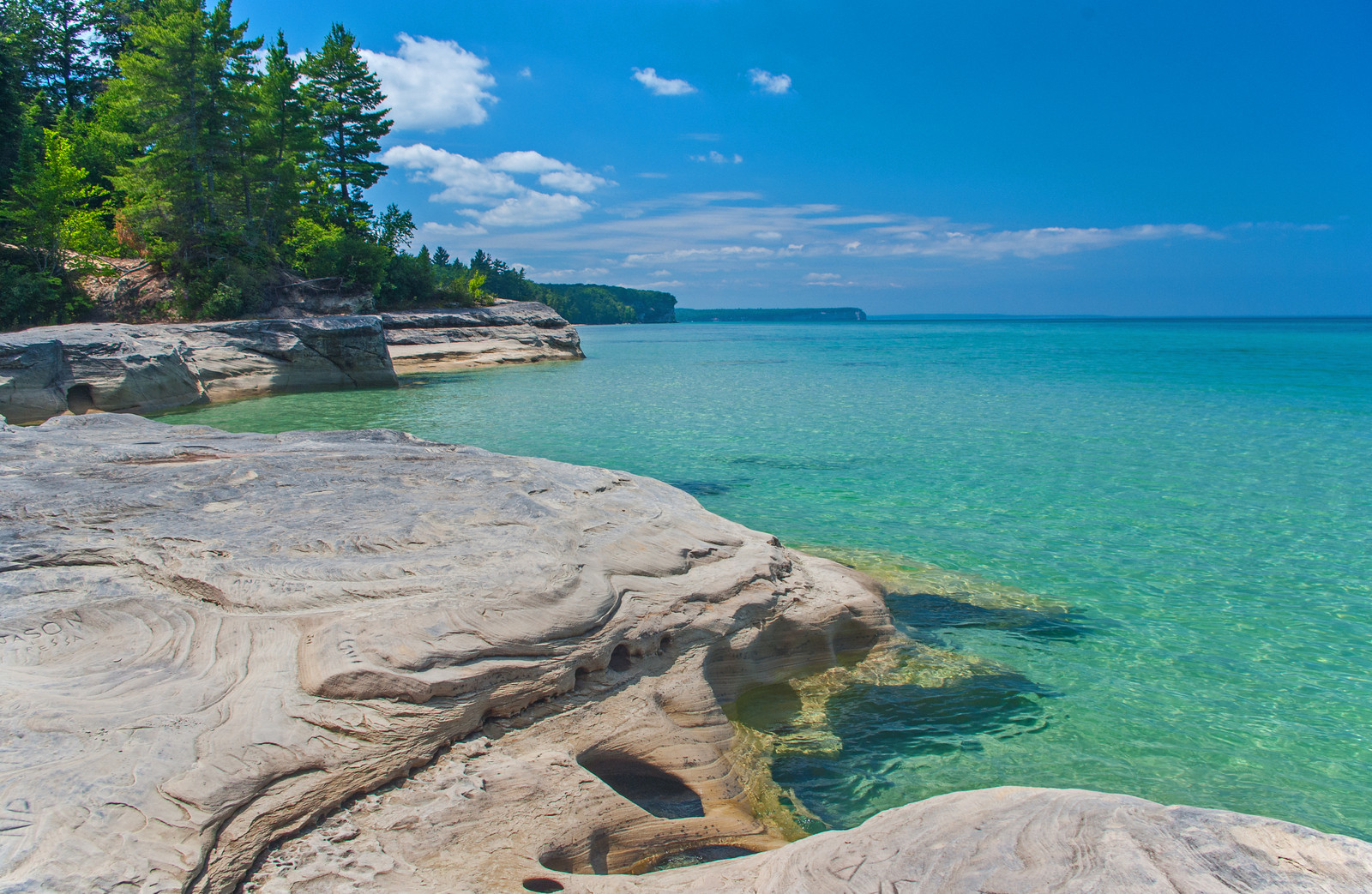
The Coves, photo by Gary of the North(Footsore Fotography)
Today’s photo is the latest cover for the Michigan in Pictures Facebook. It was taken at a beach known as The Coves in the Pictured Rocks National Lakeshore and is one of those photos to show your friends who don’t know Michigan.
Check it out background bigtacular and see & purchase more in Gary’s Pictured Rocks gallery at Footsore Fotography.
More great beaches on Michigan in Pictures!
