Iced Light in the Polar Vortex Night

Iced Light in Polar Vortex Night @ -20 °C (-4 °F)

Iced Light in Polar Vortex Night @ -20 °C (-4 °F), photo by C.T.Yeh

Here in Traverse City,  schools are closed for (I think) the 5th time since January 1st. With 4 degree temps and the wind howling at 20-30 mph, our wind chill is near 20 below. The temps across Michigan show much the same with few places in the Lower Peninsula above single digits and most of the Upper Peninsula below zero. Marquette takes the (frozen) cake with -10 before any windchill is calculated.

What big teeth you have, Winter 2014.

Check Jimmy’s photo out background bigtacular and see more in his Nature slideshow.

There’s more winter wallpaper on Michigan in Pictures, but nobody’s going to blame you if you try on something a little more summery!

Ice Balls on the Sleeping Bear Lakeshore

Lake Michigan ... ice balls III

Lake Michigan … ice balls III, photo by Ken Scott

You may recall the Lake Michigan ice balls that were seen at the Sleeping Bear Dunes lakeshore last March.  Well, they’re baaaaack. You can see a great video of the ball ice at Accuweather. Here’s the explanation of how balls ice form that I  put together from AIR PHOTO INTERPRETATION OF GREAT LAKES ICE FEATURES by Ernest W. Marshal & Frazil ice at Wikipedia:

Ball ice consists of roughly spherical masses of slush and frazil ice that accrete in turbulent water. Frazil ice is a collection of loose, randomly oriented needle-shaped ice crystals that form in open, turbulent, supercooled water. Lumps that form in the less turbulent zones are typically flattened discs, while those formed in the extremely turbulent zone near the shoreline ice where wave action is strongest form into spheres.

The author explains that ball ice is a feature common to all of the Great Lakes and can occur at any time during the winter where water turbulence breaks up a slush layer. You can read more about this in Great Lakes Ice Features.

View Ken’s photo bigger, check them out in his ice balls slideshow and see this shot with Ken in it for a sense of the scale.

One year after the End of the World

Mayan Calendar---Weather Edition

Mayan Calendar—Weather Edition, photo by katerha

In addition to marking a full year of surviving the expiration date of the previous Mayan calendar, the winter solstice happens at 12:11 PM today. EarthSky has a guide to everything you need to know about the Winter Solstice that has all the details.

The weather outside is frightful though – stay safe and take care!

Check Kate’s photo from Cedarville out background bigtacular and see more in her winter slideshow.

Time to update your background to winter? There’s 7+ years of Michigan winter wallpaper on Michigan in Pictures!

Lake Effect Snow Season in Michigan

Lake Effect 4794-09

Lake Effect 4794-09, photo by StacyN – MichiganMoments

Many in Michigan are waking up to frigid temps, high wind and snow – the perfect conditions for lake effect snow. Meteorologist Robert J. Ruhf has an excellent article on Lake-Effect Precipitation in Michigan that explains lake effect snow and rain are common in Michigan, especially in late fall and early winter as cold polar air moves across the warmer Great Lakes. 

The unfrozen waters are relatively warm when compared with the temperature of the wintertime air mass. Therefore, the temperature of the air that comes into contact with the water increases. The warmed air expands and become less dense, which causes it to rise. This is an “unstable” situation. As the air rises, the temperature decreases until it reaches the dew point, which is the temperature at which the air becomes saturated.. Ice crystals or water droplets will then begin to collect until the force of gravity pulls them down. The result is “lake-effect” precipitation. When the cP air mass is very cold, as is often the case between December and February, the precipitation falls as snow. During late autumn, however, the polar air mass may be warm enough for the precipitation to fall in the form of rain.

“Lake-effect” precipitation can cause substantial intensification of snowfall amounts in very narrow bands, often referred to as “snow belts,” along the leeward (downwind) shores of the Great Lakes. The prevailing wind direction in the Great Lakes region is westerly; therefore, most “lake-effect” precipitation events occur to the east of the lakes.

…An interesting feature of “lake-effect” is that the heaviest bands of snow do not usually occur along the immediate shoreline, but tend to fall several miles inland. Snowfall accumulations are enhanced inland because the air experiences more uplift when it is forced over hills and higher terrain. 

Read on to learn lots more about lake effect snow in Michigan including four narrow bands  – Keweenaw Peninsula, Leelanau Peninsula, the Thumb and the southwest Lower Peninsula – where geographic features and the shape of the shoreline contribute to more intense snowfall. Hang on to your hats – winter is here!

Stacy took this photo of Lake Michigan from the North Muskegon shoreline in January of 2009. See it bigger and see more in her awesome Michigan BLUE Winter 2012 slideshow.

Need a winter background?

Farmers’ Almanac calls for cold & snowy winter 2013-2014

Snowfall: Scenic Drive

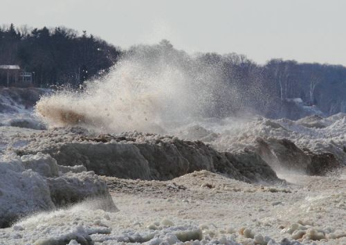
Snowfall: Scenic Drive, photo by marylea

In Farmers’ Almanac prediction: valid winter forecast or ‘darts at a dartboard’?, the Great Lakes Echo explores the accuracy of the venerable Farmers’ Almanac, writing:

…this year, like many before, bloggers, newspapers and local TV stations alike are abuzz with the Almanac’s prediction for winter 2014 – particularly a notably bitter, cold, precipitous winter for the Midwest and most of the Great Lakes region.

“This winter is shaping up to be a rough one,” the almanac reports.

So how much weight does this prediction hold?

“The value of the Farmers’ Almanac in terms of weather forecasting is no better than a comic book,” says Detroit-based meteorologist Paul Gross. “If we knew the forecast a year in advance, we’d be utilizing that knowledge by now.”

The Almanac, which famously keeps its weather predicting methods rather hush-hush, claims to be 80 percent accurate – although the lack of concrete evidence proving that claim draws some skepticism.

The Almanac also makes a questionable remark about the relationship between global warming and a winter with heavy snow.

“Brrrrr!” says the excerpt. “It looks like global warming will soon be taking a vacation to make room for Old Man Winter.”

Heavy snow in winter means quite the opposite in regards to global warming, says Gross. “What people don’t understand is that global warming means that more ocean water is evaporated into the atmosphere,” he said. “And that water vapor in the atmosphere is what becomes available to storms to create precipitation.”

Global warming isn’t “taking a vacation” to make way for the heavy precipitation, Gross said. Rather, a warming climate cause increased precipitation. “It’s shocking, but four of Detroit’s top 10 snowiest winters in history have occurred since 2002,” he said.

They add that the Almanac’s prediction does appear to be somewhat in line with predictions like the National Oceanic and Atmospheric Adminstration’s. Read on for more at the Echo.

Check Marylea’s photo out bigger and see more in her Winter 2011-2012 slideshow.

More weather on Michigan in Pictures.

100 Years after the Great Storm of 1913

NovemberGaleGrandHaven-2

NovemberGaleGrandHaven-2, photo by Rich Wyllis

100 years ago today the most devastating storm in Great Lakes history began. It raged across the Great Lakes from November 7-10, 1913. As NOAA’s commemorative website explains:

In November of 1913 the Great Lakes were struck by a massive storm system combining whiteout blizzard conditions and hurricane force winds. The storm lasted for four days, during which the region endured 90 mile per hour winds and waves reaching 35 feet in height. With only basic technology available, shipping communication and weather prediction systems were not prepared for a storm of such devastating force. When the skies finally cleared, the Great Lakes had seen a dozen major shipwrecks, an estimated 250 lives lost, and more than $5 million in damages (the equivalent of more than $117 million today).

Nicknamed the “White Hurricane” and the ‘Freshwater Fury” the 1913 storm remains the most devastating natural disaster to ever strike the Great Lakes. One hundred years later, NOAA commemorates the Storm of 1913 not only for the pivotal role it plays in the history of the Great Lakes but also for its enduring influence. Modern systems of shipping communication, weather prediction, and storm preparedness have all been fundamentally shaped by the events of November 1913.

Head over to NOAA for more on the weather technology of 1913 and today and definitely check out more on the Freshwater Fury on Michigan in Pictures!

Check Rich’s photo out bigger and see more in his slideshow.

Manitou Stormcloud and the Earth Science Picture of the Day

Manitou Stormcloud

Manitou Stormcloud, photo by ShaneWyatt

One of my favorite photoblogs is the Earth Science Picture of the Day (EPOD), and sometimes you’ll see photos from Michigan in Pictures there and vice versa. The EPOD is produced by the NASA Earth Sciences Division, and every day their stalwart blogger Jim Foster works with photographers all over the planet to highlight amazing things. In June the EPOD posted a cool photo of a roll cloud over Calgary, explaining:

Roll clouds are a type of arcus cloud often associated with turbulent weather. As is the case here, they sometimes look like a horizontal tornado. Although these cylindrically shaped clouds look quite fierce and may be observed to roll about their horizontal axis, they don’t usually generate dangerous winds. Roll clouds are typically found behind outflow boundaries but unlike shelf clouds are detached from any close-by cumulonimbus cloud.

I know that I featured a photo from Shane last Thursday, but this one was just too cool to hold back! Check his photo out bigger and see more in Shane’s slideshow.

More wild Michigan weather on Michigan in Pictures!

Great Lakes Waves offer beauty, power & danger

DSC01071P

Untitled, photo by Scott Glenn

“These are not lakes, these are the world’s eighth seas, and her bottom is littered with the wreckage of over six thousand ships.”
~The Three Sisters, Song of the Lakes

This gorgeous shot of the St. Joseph Pier Lighthouses demonstrates the incredible power of Great Lakes waves. I live in Traverse City, and this summer it feels like Lake Michigan has claimed the lives of more people than normal. Whether or not that’s true (it’s not), I thought this photo offered the perfect opportunity to share some tips and tools for staying safe on Lake Michigan, Lake Huron, Lake Superior and Lake Erie!

  • Thinking of any of the Great Lakes as anything like any lake you’re familiar with is a mistake. They are freshwater seas that can pack  incredible power. They are stronger than you and can end your life in an instant if you don’t respect them.
  • The Great Lakes Surf Rescue Project is a nonprofit dedicated to drowning prevention that keeps track of drowning statistics: 74 in 2010, 87 in 2011, 101 in 2012 and 39 so far in 2013. (you can also keep up with them on Facebook)
  • Life jackets can save your life.  U.S. Coast Guard statistics show that 90% of the people who drown in a boating or water accidents would survive with a life jacket.
  • Cold kills! Hypothermia is a danger all year round on the Great Lakes. Click that link for tips on how to stay alive if you do end up in the water.
  • Rip Currents (sometimes called “undertow” or “rip tide”) are a big danger on Michigan beaches accounting for the majority of drownings. Michigan is 4th in rip current related fatalities behind Florida, California, and North Carolina – we have “ocean force” rip currents. Learn how to beat them in this video.
  • The National Oceanic and Atmospheric Administration (NOAA) offers comprehensive Great Lakes marine forecasts.
  • The MyBeachCast smarthphone app can predict waves and warn you of hazardous conditions.
  • Do you have more tips? Share them in the comments!

Check it out bigger and see more in Scott’s Lighthouses slideshow and also check out a winter view of the pier that Scott shot.

Catch a Michigan wave on Michigan in Pictures!

Belle Isle Bolt!

Belle Isle View1D

Belle Isle View1D, photo by TroyMich (fferriolo)

BLAM!! Who’s ready for some spring storms? FYI, this is actually not a lighthouse off Belle Isle, it’s the Detroit Waterworks Intake Crib. You can have a look at on Google Maps.

Check this out big as the sky and in see more Frank’s slideshow.

More wicked weather on Michigan in Pictures!

Ice Machine: How Shoreline Ice Forms on the Great Lakes

Lake Michigan Ice by Tim Wenzel

Snowball Fight Anyone?, photo by Timothy Wenzel

One of my favorite photo blogs is the Earth Science Picture of the Day from NASA. In Wednesday’s blog, Timothy wrote:

This photo, taken on January 24, 2013, illustrates how ice on Lake Michigan’s eastern shore can achieve heights of many feet; by accretion of floating snowball-size ice balls thrown upward by wave action. The maximum wave height (crest to trough) on Lake Michigan on this day was approximately 6 ft (2 m). What results is a landscape that looks almost volcanicClick here to see video of this phenomenon. Note that the lake itself is a slurry of ice and water.

Definitely check Tim’s video out! See the photo background bigtacular and see more in Timothy’s work including more photos from the day in his Weather Underground gallery.

More EPOD awesomeness on Michigan in Pictures!