Michigan making a run at 100

Sea and Sky by Walter E. Elliott

Sea and Sky by Walter E. Elliot

mLive’s Mark Torregrossa shares that a heat dome will cover much of Michigan beginning Saturday that is expected to keep temps in the 90s until at least next Thursday!! Mark shares that Michigan hasn’t hit 100 degrees since 2012 since our highest heat in recent years has been coming from the northwest:

This won’t be the case with the weekend’s and next week’s heat. The coming heat is going to build in from the southeast. This means what should be the hottest corner of Michigan will be the hottest. When all of the concrete and pavement of southeast Michigan gets hot it can get really hot.

It will get really hot. Detroit, Ann Arbor and Monroe will make a run at 100 degrees. If so it would be the hottest temperatures in those cities since 2012. (see the temperature map below)

Walter took this yesterday in Grand Haven as a storm rolled across Lake Michigan, and I’ve shared a couple more sizzling shots! See many more at Images by Walter E. Elliot on Facebook and view & purchase his work on his website.

Support Michigan in Pictures with Patreon

Iced Over on Mackinac Island

Iced Over by Joann's Fudge of Mackinac Island

Iced Over by Joann’s Fudge of Mackinac Island

Today is one of those days when I see the photo first and go looking for the post because honestly WOW! So here are some updates:

When the huge ice storm hit, Joann’s Fudge of Mackinac Island shared this photo & noted they might suffer some shipping delays. In addition to a donation to one of the places above, consider buying a little fudge from Joann’s! Here are some more great shots including one of them taking advantage of the ice storm by playing hockey and some great lilac photos from the upcoming Mackinac Island Lilac Festival (June 6-16, 2025). See lots more of their pics on their Facebook.

Support Michigan in Pictures with Patreon

Northern Michigan Ice Is (not) Nice

Deer in the ice storm by Jeremy Bassett

Deer in the ice storm by Jeremy Bassett

From Friday night through Sunday morning, Northern Lower Michigan was hit with a massive ice storm that left tens of thousands without power, closed the Mackinac Bridge with “the worst ice we’ve every seen on the Bridge”, and led Gov Whitmer to declare a state of emergency in Otsego, Oscoda, Montmorency, Presque Isle, Emmet, Charlevoix, Cheboygan, Crawford, Mackinac and Alpena counties. Great Lakes Energy shared the status as of yesterday morning

✅ Since the storm began, power has been restored to over 56,000 members.

⚠️ Just over 45,000 Great Lakes Energy (GLE) members remain without power this morning across 15 of our 26 counties.

🌨️ Unfortunately, a new storm system hit our southern territory late yesterday, causing additional damage and compounding restoration challenges.

Here are some more pics by Great Lakes Energy Facebook along with some from the Mackinac Bridge Authority, Interlochen Public Radio, and the deer at the top and the last two of escaped horses and the ice storm in Onaway by Jeremy Bassett via 9 & 10 News.

Got any to share? Post them on our Facebook or in the comments below!!

Support Michigan in Pictures with Patreon

Woody the Woodchuck waves goodbye to winter

 Woody the Woodchuck by Howell Nature Center

Woody the Woodchuck by Howell Nature Center

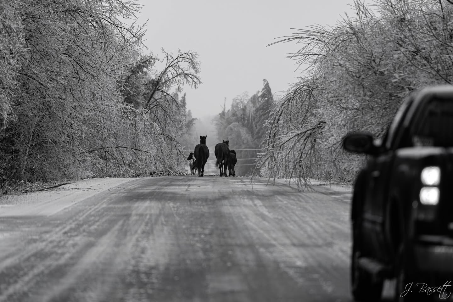
The Howell Nature Center shares: Groundhog Day 2025 is a wrap! Woody has predicted EARLY SPRING! 🌷🪻☀️ Thank you to everyone who came out to help us celebrate with Michigan’s official woodchuck. This was Woody’s 27th prediction, and her accuracy rate is about 65%!

So keep your Punxsutawney Phil forecast of 6 more weeks of winter, I’m going with Michigan’s official groundhog! Last year the Howell Nature Center shared why the event is so meaningful to them, education:

Groundhogs are often villified because of their digging habits, and it is easy to forget about their neat adaptations and their role in the ecosystem. We love sharing information about them to increase understanding, and this event gives Woody the opportunity to serve as an ambassador for her species to help people live in harmony with woodchucks.

DID YOU KNOW…

🐾 Woodchucks dig burrows that can be 50 ft long and include several different chambers for different purposes like raising young, hibernating, and toileting? Other species will even move into abandoned chambers!

🐾 With all that digging, woodchucks help aerate soil and recycle nutrients to increase soil health.

🐾 Woodchucks help disperse seeds, which promotes plant growth and diversity.

🐾 Woodchucks sometimes eat insects, which helps eliminate garden pests like grubs.

🐾 Woodchucks are an important part of the ecosytem and provide food for predators.

🐾 Woodchucks, also known as “whistle pigs”. are one of our only true hibernators in MI.

🐾 Their body temperatures can drop to 40 F and their heart rates to 4 beats per minute during hibernation.

Our wildlife helpline is available to help solve conflict with groundhogs that are living in undesirable places. We have lots of tips and tricks to humanely evict them and encourage them to move to a different location. Trapping and relocating is never a good idea, since it often results in death of groundhogs that are not able to find resources in a new location or of babies that have been orphaned by the removal of their mother.

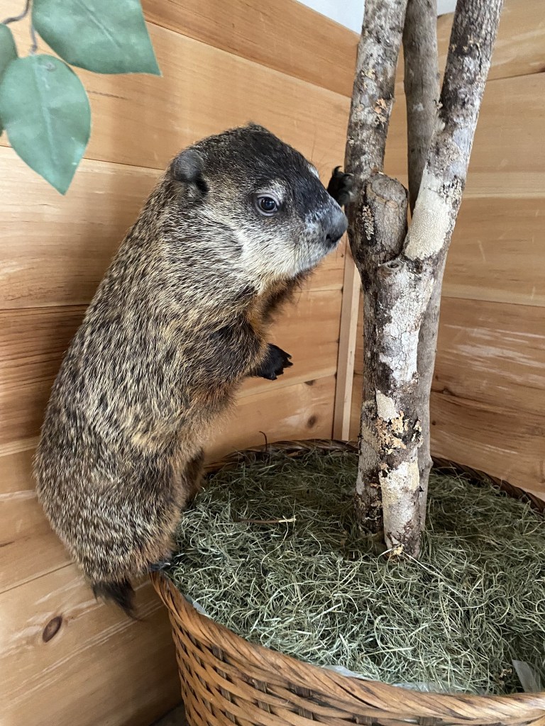
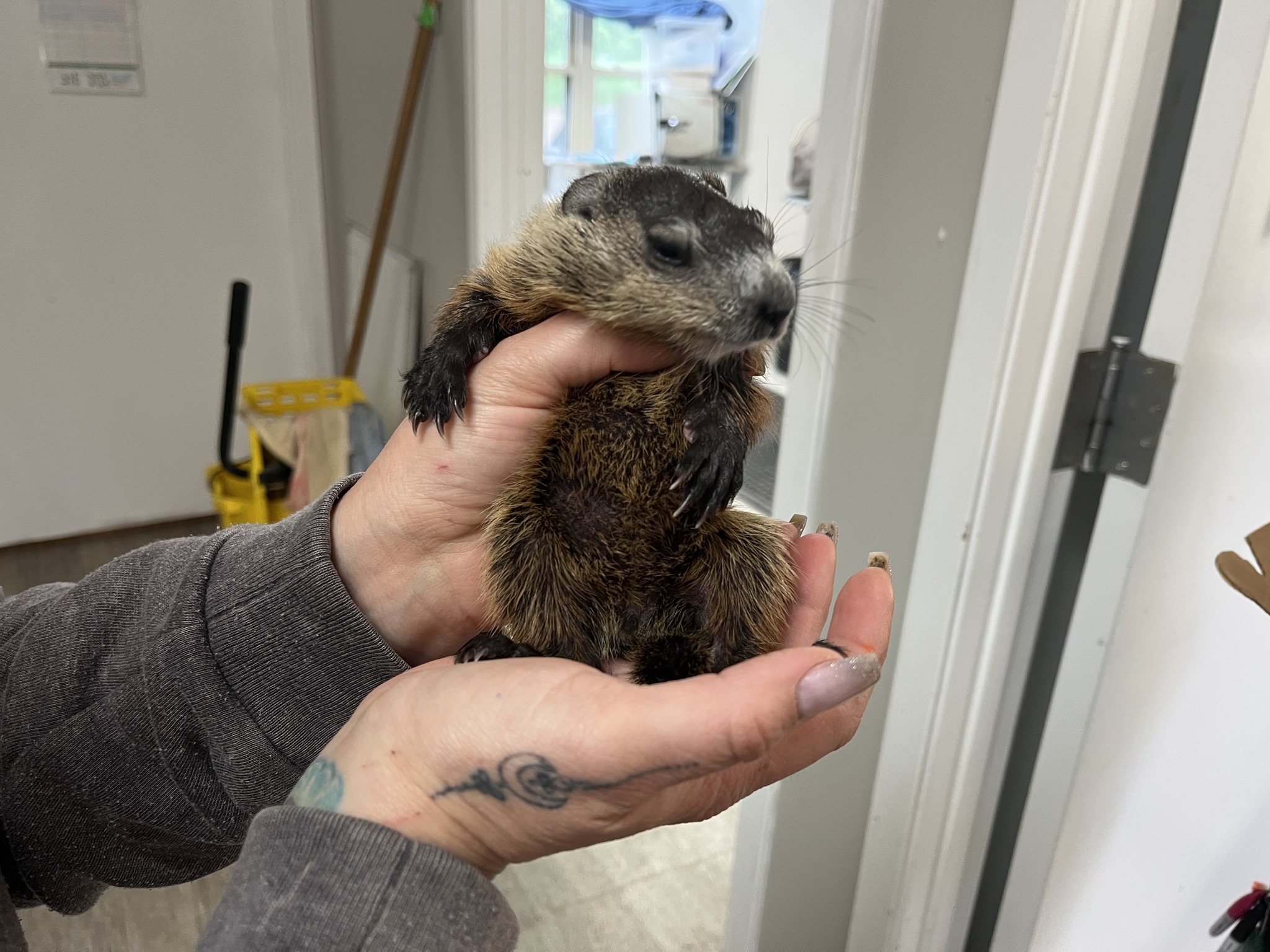
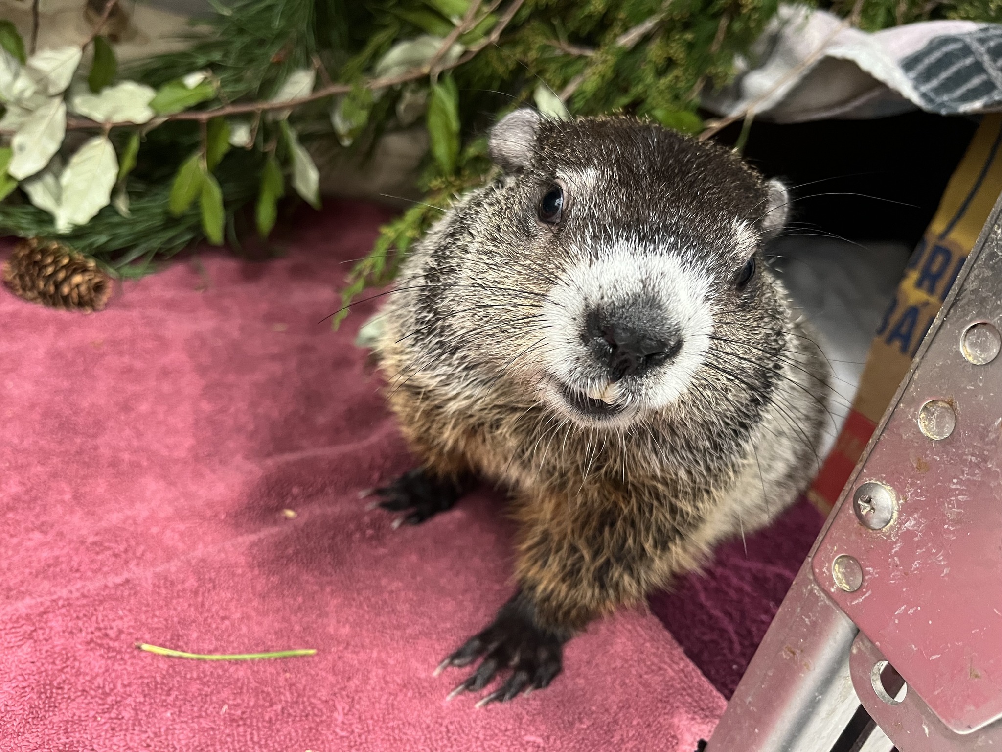
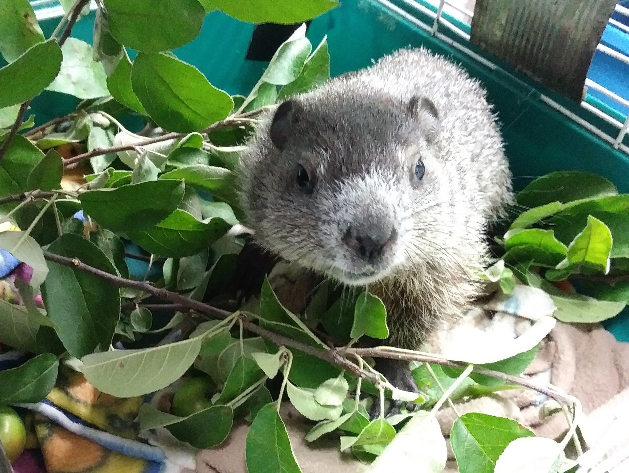
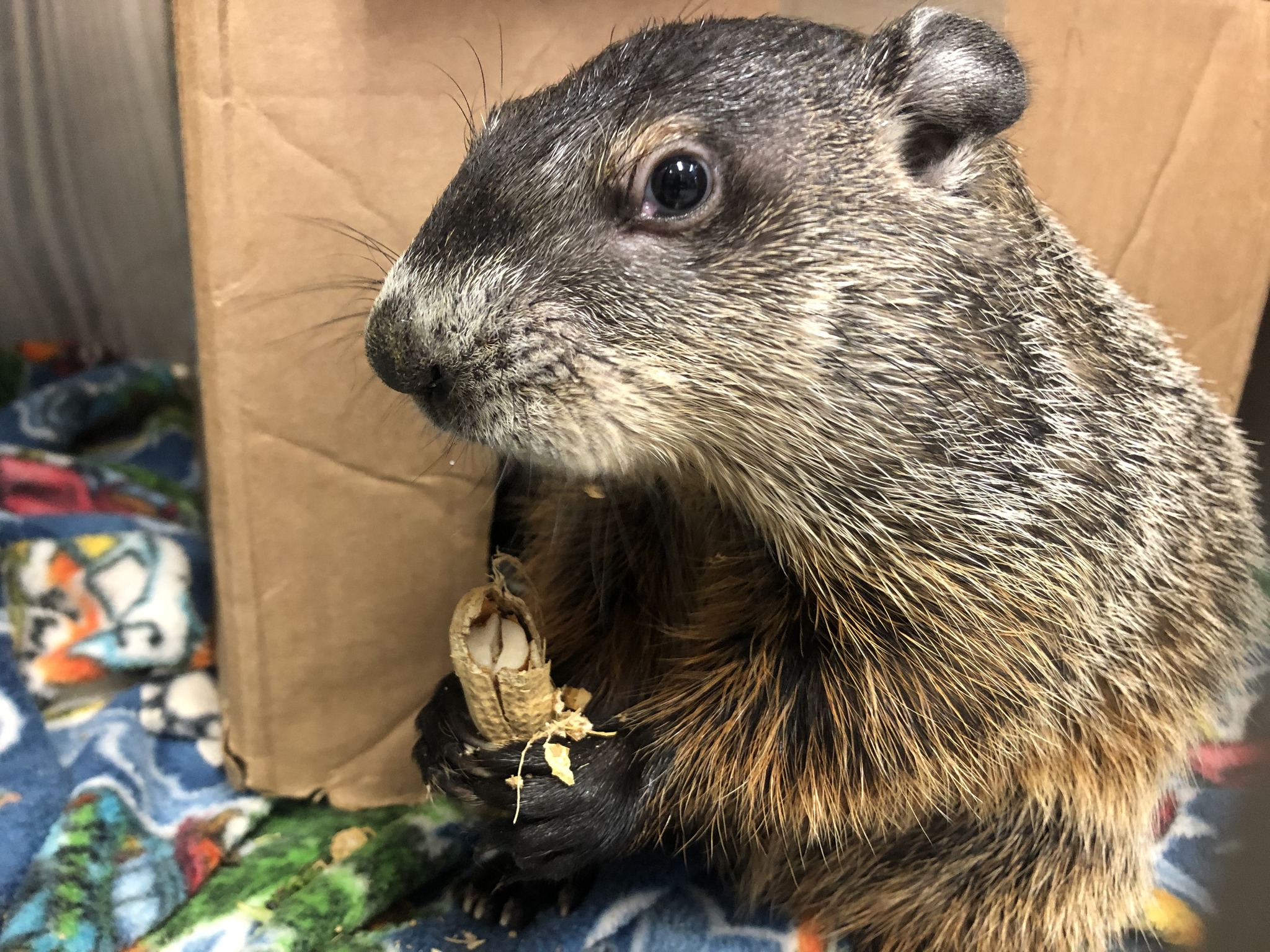
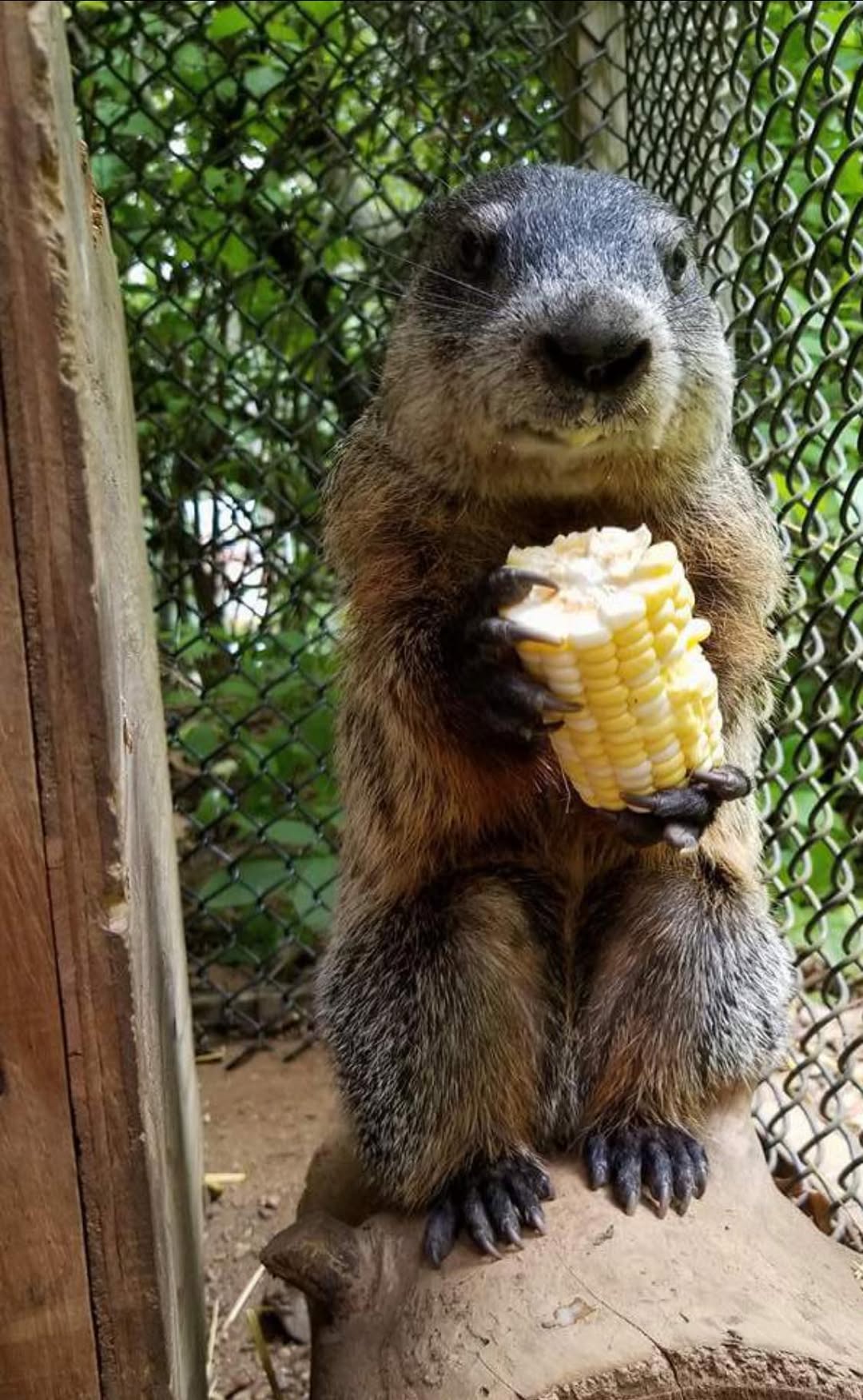
I hope that you are able to make a donation on their website. Here are some of the injured and orphaned chucks they have cared for in their rehabilitation clinic.

Mounds of snow for Michigan

Lake Michigan Ice Mounds by Mark Swanson

Lake Michigan Ice Mounds by Mark Swanson

The Lansing State Journal reports the National Weather Service says that a triple threat of subzero temperatures, high winds and ice-free Great Lakes really piled up the lake effect snow last week:

“This snowy week is nearly at an end, including a visit from real Arctic air, and many towns near Lake Michigan and Lake Superior got a foot or two of fresh snow as a result,” the NWS said. “Clearly, the vast majority of snow was a result of lake effect, as plenty of other parts of Michigan only saw an inch or two at best.”

Air temperatures in Michigan fell below zero Jan. 18-22. In some cases, the thermometer didn’t read above zero for two days. The coldest reading in the state came Monday night when Stambaugh, in the western UP, registered minus 30 — before wind chill. The town also saw minus 28 on Tuesday night while Ironwood’s NWS observer recorded minus 27.

You can see that the conditions have also piled up shoreline ice in these pictures that Mark took over the weekend at Lincoln Township Beach just north of Grand Mere State Park. Here are some more recent ones and a shot from summer of 2016 below. More in Mark’s 2025 gallery on Flickr!

Support Michigan in Pictures with Patreon

Get Ready for the Siberian Express

Polar Express Selective Color by Charles Bonham

Polar Express Selective Color by Charles Bonham

mLive meteorologist Bill Vandermolen shares that frigid air that began its journey in Siberia will be descending on Michigan on Monday:

When we get our normal cold here in Michigan the air moves from southwest Canada, across the northern Plains and into the Great Lakes region. A little stiffer brand of cold comes from northwest Canada in the Yukon Territory. Our most dangerous cold comes straight from the north. If the air is really cold it will originate in Siberia, cross over the North Pole and then pour south into the Great Lakes and Northeast.

We are probably just lucky the Great Lakes still have 35 degree to 40 degree surface waters. This same Arctic outbreak of cold would take us 10 degrees colder if it happened with colder Great Lakes’ waters. In looking at the pattern I wouldn’t be surprised to see another Arctic outbreak in a week or two when the lake water is colder.

Lucky indeed because even with the temperature moderation of the Great Lakes, the temps Monday & Tuesday do not look fun!

Charles is one of Michigan in Pictures’s most enduring photographers. He took the photo below earlier this week in Leland’s Fishtown & you can see more in his Steam Engine, Railroad Photos gallery on Flickr.

Fishtown Spillway by Charles Bonham

Fishtown Spillway by Charles Bonham

Temps on Monday & Tuesday

Support Michigan in Pictures with Patreon

Michigan offers Winters like no other!

Winter Sunshine Waves by Matt Kazmierski

Winter Sunshine Waves by Matt Kazmierski

mLive’s Mark Torregrossa is my favorite Michigan meteorologist most especially for articles like the one he shares today about why Michigan’s winter weather is unlike anywhere else in America:

Several times a year I can point out to you weather we see nowhere else in America. One of those times is when we get Arctic air crossing the 40-degree water of Lake Michigan.

Look at the low temperature forecast for tomorrow morning, Jan. 9. You could call a friend in northeast Lower Michigan, and they will tell you it’s very cold and near zero degrees. Look at the “warmer” air that blows off of 40-degree Lake Michigan. We will have spots around Kalamazoo, South Haven and Benton Harbor that only drop to 20 degrees. Southeast Lower Michigan can be colder than the northwest shoreline of Lake Michigan at this time of year. Thursday morning’s map clearly shows that strange temperature pattern. We also see the warmer air under the clouds and lake effect snow stretching southeast off Lake Michigan.

Matt took this at Nordhouse Dunes back in March of 2022 & the one below in March of 2023. Head over to his Flickr for his latest!

Support Michigan in Pictures with Patreon

snow squalls & snow daze!

Snow squalls at the Straits by Paula Liimatta

Snow squalls at the Straits by Paula Liimatta

mLive’s Tanda Gmiter shares that the cold front rolling into Michigan is packing a powerful punch:

Snow squalls are in the forecast across Michigan as a cold front rushes in, beginning today and lasting into Thursday. Drivers should be aware, as these can be a serious hazard if you’re out on the road when a squall whips up. Snow squalls cause white-out conditions and can leave roads icy. They are forecast to develop in West Michigan this afternoon, then over a several-hour period tonight in Southeast Michigan as a strong cold front arrives, National Weather Service (NWS) meteorologists in the Grand Rapids and Detroit offices said. The front is expected to spark some rapidly-changing weather conditions.

Paula got this shot of snow squalls buffeting the Mighty Mackinac Bridge back in January of 2018. See more in her Winter 2017 gallery including this reminder than for all its problems, snow can be SUPER FUN!!!

Snow Daze by paula liimatta

Support Michigan in Pictures with Patreon

NOAA’s Michigan 2024-2025 Winter Outlook

Chill Out by PeeblesPair

Chill Out by PeeblesPair

I’ve been hanging onto this post so long I was worried we’d have snow before I shared it!! The National Oceanic & Atmospheric Administration (NOAA) has released their seasonal outlook for Winter 2024-2025 which says (in part):

This winter, NOAA predicts wetter-than-average conditions for the entire northern tier of the continental U.S., particularly in the Pacific Northwest and the Great Lakes region, along with northern and western Alaska.

“This winter, an emerging La Nina is anticipated to influence the upcoming winter patterns, especially our precipitation predictions,” said Jon Gottschalck, chief of the Operational Prediction Branch of the Climate Prediction Center. La Nina conditions are expected to develop later this fall and typically lead to a more northerly storm track during the winter months, leaving the southern tier of the country warmer and drier.

Rae took this photo at Point Betsie Lighthouse on January 1st of this year. Follow her on Flickr & on Instagram for more!

The 2024-2025 U.S. Winter Outlook map for temperature shows the greatest chances for cooler-than-average conditions in the Pacific Northwest of the U.S. (Image credit: NOAA)

The 2024-2025 U.S. Winter Outlook map for precipitation shows wetter-than-average conditions are most likely across the Great Lakes region of the U.S.. Drier-than-average conditions are forecast for parts of the U.S. Gulf Coast. (Image credit: NOAA)

The 2024-2025 U.S. Winter Outlook map for precipitation shows wetter-than-average conditions are most likely across the Great Lakes region of the U.S.. Drier-than-average conditions are forecast for parts of the U.S. Gulf Coast. (Image credit: NOAA)

Support Michigan in Pictures with Patreon

2024’s Hurricanes are breaking our limits

Sandy’s Frankenwaves by Cory Genovese

8PM EDT: This is nothing short of astronomical. I am at a loss for words to meteorologically describe you the storms small eye and intensity. 897mb pressure with 180 MPH max sustained winds and gusts 200+ MPH. This is now the 4th strongest hurricane ever recorded by pressure on this side of the world. The eye is TINY at nearly 3.8 miles wide. This hurricane is nearing the mathematical limit of what Earth’s atmosphere over this ocean water can produce. -Orlando Meteorologist Noah Bergren

The phrase “nearing the mathematical limit of what Earth’s atmosphere over this ocean water can produce” is one of the most terrifying I have ever read, especially when it directly follows Hurricane Helene that killed over 200 people and wrought devastation even in the mountains. Could this be the hurricane cycle that wakes people up to the reality of a changed climate or will we keep acting like it’s normal for hurricanes to wipe mountain towns off the map? Time will certainly tell.

While it’s too early to forecast the impact of Milton on Michigan, Hurricane Sandy in 2012 produced the second highest wave height ever on Lake Michigan of 21.7 feet – click for all kinds of Lake Michigan Hurricane Sandy weather data from the NWS. Cory took this at Sugar Loaf just outside of Marquette way back in November of 2012 in the aftermath of Hurricane Sandy. See more in his Portfolio gallery on Flickr.

Support Michigan in Pictures with Patreon