Lake Superior Thunderhead

Lake Superior Thunderhead

Lake Superior Thunderhead, photo by Lake Superior Photo

So far this summer we’ve gotten some free fireworks show such as the storm that swept through last weekend. Shawn wrote:

It was fireworks over the lake last night, my dog was not pleased, however I was ecstatic. Lightning was going off a couple times a second and it did not let up, but stayed mostly in the clouds. I watched this for over an hour, and it just drifted by, stars overhead the entire time – go big screen to see the stars right top of frame.

So… what are you waiting for? Go background big and see more at Lake Superior Photo on Facebook.

Have a great weekend everyone!

Beautiful Beast

Beautiful Beast

Beautiful Beast, photo by Jamie MacDonald

Yesterday saw strong storms in southeast Michigan including some tornado sightings (click that link for photos).

Jamie took this shot last week with a Rokinon 7.5mm Fisheye. Check his photo out bigger and see more in his Stormy Weather slideshow.

More wild & wonderful weather on Michigan in Pictures.

Michigan in the Deep Freeze

Icy Evening

Icy Evening, photo by GLASman1

Some of the coldest air in decades has moved into Michigan, producing morning temps in the low teens to single digits and packing windchills over -20! The lowest temp? Ironwood in the western UP at -26! The weather has closed schools in much of the state and has every news outlet and the Michigan State Police warning you about the extreme conditions.

The Freep is reporting snowfall totals of 13 inches of snow in Holly and Waterford, more than 16 inches on the ground in Flint and 17 inches of snow in Clarkston as of just after midnight last night! They also have a collection of photos sent in by metro residents.

Weather Underground’s winter storms page has Winter Storm Ion page that will be a good resource for looking back.

mLive has a nice collection of storm information. Meteorologist Mark Torregrossa says that lower Michigan will take the brunt of the snowfall, anywhere from 5-11 inches! They also have some tips for dealing with the extreme cold.

If you live in west Michigan, you may remember the blizzard of January 6, 1999 which dumped 30 inches of snow!

Mark’s photo was taken at Point Betsie lighthouse in January of 2012 and is also the latest cover on the Michigan in Pictures Facebook. You can view it bigger and see more in his Pte Betsie Lighthouse slideshow.

100 Years after the Great Storm of 1913

NovemberGaleGrandHaven-2

NovemberGaleGrandHaven-2, photo by Rich Wyllis

100 years ago today the most devastating storm in Great Lakes history began. It raged across the Great Lakes from November 7-10, 1913. As NOAA’s commemorative website explains:

In November of 1913 the Great Lakes were struck by a massive storm system combining whiteout blizzard conditions and hurricane force winds. The storm lasted for four days, during which the region endured 90 mile per hour winds and waves reaching 35 feet in height. With only basic technology available, shipping communication and weather prediction systems were not prepared for a storm of such devastating force. When the skies finally cleared, the Great Lakes had seen a dozen major shipwrecks, an estimated 250 lives lost, and more than $5 million in damages (the equivalent of more than $117 million today).

Nicknamed the “White Hurricane” and the ‘Freshwater Fury” the 1913 storm remains the most devastating natural disaster to ever strike the Great Lakes. One hundred years later, NOAA commemorates the Storm of 1913 not only for the pivotal role it plays in the history of the Great Lakes but also for its enduring influence. Modern systems of shipping communication, weather prediction, and storm preparedness have all been fundamentally shaped by the events of November 1913.

Head over to NOAA for more on the weather technology of 1913 and today and definitely check out more on the Freshwater Fury on Michigan in Pictures!

Check Rich’s photo out bigger and see more in his slideshow.

Hurricane Huron: September 11-15th, 1996

Massive Wave at Port Sanilac

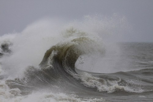
September Storm: Port Sanilac, photo by StormchaserMike

Hurricanes in Michigan?? from NOAA looks at several hurricane force storms and has this to say about “Hurricane Huron”:

While this storm was not from remnants of a tropical system, its development over Lake Huron had many uncanny likenesses to tropical systems…

The first likeness was its timing, forming over the Great Lakes right at the height of the typical hurricane season, September 11-15th, 1996. What started as a typical core-cold 500 MB low pressure system evolved into a warm-core system as it settled over the relatively warm waters of the Great Lakes, in particular, Lake Huron. The low pressure system actually had moved past Lake Huron but then retrograded, or was “drawn back”, to the relatively warm waters of Lake Huron. (Similar to the tropics, the Great Lakes usually reach their warmest water temperatures late August into mid September.) The storm then deepened and intensified at the lower levels of the atmosphere compared to aloft, typical of a warm-core low. It is believed that the warm waters of Lake Huron and associated low level instability over the lake were, to a large extent, the major contributing factors in this storm’s evolution. The storm went on to form a broad cyclonic circulation, including the “spiral bands and eye”, typically seen in hurricanes! At one point, the cyclone produced tropical storm force winds (39 – 73 mph) and some of the spiral bands even had rainfall exceeding 10 cm (better than four inches), causing some flooding.

This “Hurroncane” reached its maximum intensity during the day on September 14th, when a central pressure of 29.34 inches (993 MB) was recorded in the late morning by a Lake Huron buoy that fortunately was positioned, at one point, in the “eye”. By 2 PM, that “eye” measured close to 20 miles across and had a ring of tall convective clouds surrounding it, strongly resembling that of an “eye wall”. The convective showers encircled the “eye” well out over 300 miles.

You can read on for more including a satellite photo of the distinctive storm, check out Wikipedia’s entry on the 1996 Lake Huron cyclone, or go straight to the very detailed academic paper on Hurricane Huron that this article draws from.

Check Mike’s photo out bigger and see more in his awesome September Gale on Lake Huron slideshow. Mike also has a cool video of the storm on YouTube!

More hurricane-like weather on Michigan in Pictures.

Stormborn

Stormborn

Stormborn, photo by adonyvan

Jiqing Fan thinks that the dragon that hatches from this would be a match for Daenerys Stormborn’s… Check it out bigger and see more (including another view) in his Houghton / UP Michigan slideshow.