Over the River…

Wintry Seven Bridges

Wintry Seven Bridges, photo by Heather Higham

AAA Michigan reports that about 1.5 million Michiganders are heading over the river and through the woods for the Thanksgiving holiday. The good news is that gas prices are the lowest since 2009 – down 40 cents from last year. The bad news is another weather system that’s dropping freezing rain & snow, closing schools and

View Heather’s photo bigger and see more in her Rivers slideshow. She took the photo at the Seven Bridges Natural Area near Kalkaska.

There’s more rivers and more bridges on Michigan in Pictures.

A Fall Drink of Water

Doe

Doe, photo by sarah-nussbaumer

Here’s hoping your weekend holds a lot of autumn beauty … and a little bit of wonder.

Check it out bigger and see more in Sarah’s Autumn slideshow.

More fall photos on Michigan in Pictures.

Kawkawlin River: the Place of the Pike Fish

Kawkawlin River

Kawkawlin River, photo by conradthedog

A Brief History of the Kawkawlin River from the Kawkawlin Watershed Property Owner Association says that the native name for Kawkawlin was U GUH KON NING or ‘place of pike fish’. They add that the Saginaw Treaty of 1819 was negotiated by Lewis Cass with the Chippewa Indians and opened the lands of Saginaw Valley to settlers for $1.25 per acre and have lots more history & information at the link above.

Check out Jon’s photo background big and see more in his Michigan slideshow.

Many more rivers on Michigan in Pictures.

Waterfall Wednesday: Sturgeon Falls in Ottawa National Forest

Sturgeon Falls

Sturgeon Falls, photo by Wenström

I can’t get enough of the great shots of snowmelt-fueled U.P. rivers. Go Waterfalling’s page on Sturgeon Falls says:

Sturgeon Falls is located in the Sturgeon River Gorge Wilderness in Ottawa National Forest. The Sturgeon River has carved out a deep, forested gorge, that is 300 feet deep in some places. The falls are located deep in the gorge. The drop is only 30 feet, but the river is very powerful. Above the falls the river is well over 100 feet wide. It then narrows into a chute only about 30 feet wide before shooting over the falls, spraying mist in all directions.

Read on for directions. The Sturgeon River is a Michigan Wild & Scenic river as well!

Check Sven’s photo out on black and see more in his UP Michigan Waterfalls slideshow.

Many more Michigan waterfalls on Michigan in Pictures!

West Michigan’s Rogue River

Rogue River Reflection

Rogue River Reflection, photo by MichellePhotos2

Wikipedia’s Rogue River entry says that this 48 mile long river is a major tributary of the Grand River that runs through Kent and Newaygo counties and the Rogue River State Game Area.

Its headwaters are a series of ditches that drain the old Rice Lake bed near Grant for agricultural purposes.

…Originally named “Rouge River”, the river’s appellation was altered in the 19th century due to the printing error of a Wisconsin mapmaker. As a frontier waterway, the historic Rogue River was of major importance to local tribes and traders. During the lumber era in the latter 19th century its waters floated timber to the mills of the Grand River valley, and the riverboat Algoma plied its way northward along Rogue giving its name to the Kent county township of Algoma.

Rogue River is designated as “Country Scenic” under Michigan’s Natural Rivers Act. It is popular with trout fishers and local youth who have floated the river by innertube since the mid-20th century. It is intersected in parts by the White Pine Trail. It varies from 15 feet (4.6 m) wide in the upper sections to 80 feet (24 m) wide near its end and is 1 to 4 feet (0.3 to 1.2 m) deep. There are “holes” in the river up to 15 feet (4.6 m) in depth.

You can get the management plan, maps and more from the DNR’s Rogue River Page.

View Michelle’s photo on black and see more in her slideshow.

More Michigan rivers on Michigan in Pictures.

Ice on the Chippewa River

_JMC5873aw

_JMC5873aw, photo by Jeff Caverly

Wikipedia’s Chippewa River (Michigan) says that the river runs 91.8 miles from its beginning in northeast Mecosta County in the village of Barryton to where it flows into Big Cranberry Lake in southwest Clare County. It’s a tributary of the Tittabawassee River and part of the Saginaw River drainage basin.

To learn more about the river and some of the natural preserves on the river, visit the Chippewa River Watershed. You can also check out the Chippewa River Water Trail.

Get Jeff’s photo background bigtacular and see more in his slideshow.

More Michigan rivers on Michigan in Pictures.

Great Lakes water levels: Then & Now Edition

"... is the Lake Michigan water level low?" ...

“… is the Lake Michigan water level low?”, photo by Ken Scott

This photo is from a feature on today’s Leelanau.com blog about the historic water lows on the Great Lakes. It includes a great video so definitely check it out.

Leland is my home town and to see the difference from just 27 years is astonishing!

See it bigger, view more in Ken’s massive Leland/Fishtown slideshow and read an extensive discussion on Facebook.

More Lake Michigan on Michigan in Pictures.

Michigan Wild & Scenic Rivers: Manistee River

Manistee River, near Sharon, Michigan

Manistee River, near Sharon, Michigan, photo by gregorydseman

It is hereby declared to be the policy of the United States that certain selected rivers of the Nation which, with their immediate environments, possess outstandingly remarkable scenic, recreational, geologic, fish and wildlife, historic, cultural or other similar values, shall be preserved in free-flowing condition, and that they and their immediate environments shall be protected for the benefit and enjoyment of present and future generations.
~Wild & Scenic Rivers Act, October 2, 1968

Michigan has 16 nationally designated Wild & Scenic Rivers. The stretch of the Manistee River from the DNR boat ramp below Tippy Dam to the Michigan State Highway 55 Bridge is the designated stretch (click for map and river management plan). They explain:

The Manistee Wild and Scenic River is well known for beautiful scenery, excellent fishing and a variety of recreational activities. In the spring and fall, high numbers of anglers are attracted to the superb salmon and steelhead runs. During the summer, walleye and pike fishing become the primary recreational activity. The river supports a variety of other recreational uses including wildlife viewing, hiking, canoeing and hunting.

Private businesses and government agencies have developed a variety of facilities and services to meet the expanding recreation demands of the public. Commercial guided fishing is one of the most popular activities on the Manistee River. The amount of recreational use fluctuates from year to year, mostly based on the fishing runs and local economic factors. There are eight developed river access sites within the wild and scenic river corridor. The Forest Service maintains sites at High Bridge, Bear Creek, Rainbow Bend and Blacksmith Bayou. The state of Michigan operates a river access site at Tippy Dam. Private recreation sites include Big Manistee Riverview Campground and Coho Bend Campground. The U.S. Forest Service developed recreation sites along the Manistee River require a vehicle parking pass under the Recreation Enhancement Act.

Greg says he took this photo back in 1998 when the river had more water – check it out bigger and see more in his slideshow.

More Wild & Scenic Rivers on Michigan in Pictures!

Michigan Wild & Scenic Rivers: Au Sable River

Changing Skies over the Au Sable HDR

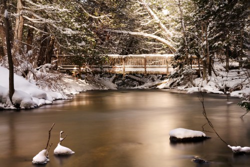
Changing Skies over the Au Sable HDR, photo by hz536n/George Thomas

It is hereby declared to be the policy of the United States that certain selected rivers of the Nation which, with their immediate environments, possess outstandingly remarkable scenic, recreational, geologic, fish and wildlife, historic, cultural or other similar values, shall be preserved in free-flowing condition, and that they and their immediate environments shall be protected for the benefit and enjoyment of present and future generations.

~Wild & Scenic Rivers Act, October 2, 1968

Michigan’s has 16 Wild & Scenic Rivers. One of these is the Au Sable River. The 23 mile stretch of the river from Mio downstream to the 401 Bridge is the portion that has the National Scenic River designation, considered to offer some of the best canoeing in Michigan. It’s also a blue ribbon trout stream with excellent brown trout fly fishing and holding walleye, pike and bass as well.

With all that going for it, I was surprised by the lack of quality information available online about this river. Sometimes, having to dive a little deeper pays off as it has this morning with Michigan’s Au Sable River: Today and Tomorrow by G. E. Hendrickson. The paper was prepared way back in 1966 for the Michigan Department of Conservation under Gov. George Romney’s administration in conjunction with the Geological Survey and the United States Department of the Interior.

Located in the northern lower peninsula of Michigan, the Au Sable is known for its high water quality, scenery, recreational opportunities, coldwater fishery, and historic and cultural significance. It may just be the. If that were not enough reason to visit the river, the Au Sable is also one of the best canoeing rivers in the Midwest.

Two south-flowing rivers rise in the country north of Grayling. One, the Manistee, turns west to Lake Michigan; the other, the Au Sable, turns east to Lake Huron. Both are famous trout streams, but the Au Sable is perhaps enjoyed and cherished by more people than any other Michigan river. Cool clean flowing water, natural cover, and gravel spawning beds make it an outstanding trout stream. Its natural beauty attracts canoeists, campers, and cabin dwellers.

The upper Au Sable is a young river, as rivers go, having settled down to its present course after the glaciers retreated about 12,000 years ago. It was named by early French explorers, the name meaning “River of Sands.” Following close on the heels of the retreating ice, the earliest Indians moved into Michigan, and possibly into the Au Sable area. The Indians hunted for deer, bear, mastodons, giant beaver, caribou, and other wildlife. They also fished for many species. To the Indians the Au Sable was a source of food and drink and a highway for canoe travel. Early white traders and explorers used the river for the same purposes, while the lumbermen valued it chiefly for transporting logs.

You can read on for a lot more including the story of the extinction of the Au Sable river Grayling and Au Sable River drift boats.

Check this out background bigtacular and see a ton more in George’s Fall & Autumn slideshow.

More of Michigan’s Wild & Scenic Rivers on Michigan in Pictures.

Michigan Wild & Scenic Rivers: Manistee River

Ox Bow on the Manistee River

Ox Bow on the Manistee River, photo by jimflix!.

Michigan has 16 nationally designated Wild & Scenic Rivers. The Wild & Scenic Rivers Act of October 2, 1968 provided for federally designated rivers that “possess outstandingly remarkable scenic, recreational, geologic, fish and wildlife, historic, cultural or other similar values.” A 26 mile section of the Manistee River was added in 1992 from the Michigan DNR boat ramp below Tippy Dam to the Michigan State Highway 55 Bridge. On the Manistee’s page at the Wild & Scenic River website they say:

The Manistee Wild and Scenic River is well known for beautiful scenery, excellent fishing and a variety of recreational activities. In the spring and fall, high numbers of anglers are attracted to the superb salmon and steelhead runs. During the summer, walleye and pike fishing become the primary recreational activity. The river supports a variety of other recreational uses including wildlife viewing, hiking, canoeing and hunting.
Private businesses and government agencies have developed a variety of facilities and services to meet the expanding recreation demands of the public. Commercial guided fishing is one of the most popular activities on the Manistee River. The amount of recreational use fluctuates from year to year, mostly based on the fishing runs and local economic factors. There are eight developed river access sites within the wild and scenic river corridor. The Forest Service maintains sites at High Bridge, Bear Creek, Rainbow Bend and Blacksmith Bayou. The state of Michigan operates a river access site at Tippy Dam. Private recreation sites include Big Manistee Riverview Campground and Coho Bend Campground. The Forest Service developed recreation sites along the Manistee River require a vehicle parking pass under the Recreation Enhancement Act.

View this photo background big and in Jim’s Manistee River slideshow.

More Wild & Scenic Rivers on Michigan in Pictures!