Under Petit Portal

Under Grand Portal

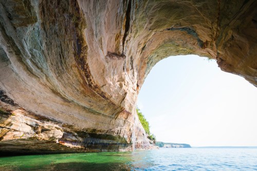
Under Petit Portal, photo by AllieKF

Here’s a shot from a place on my Michigan kayaking bucket list – Petit Portal (also known as Petit Arch and Arch Rock by some) and other cliff formations of the Pictured Rocks National Lakeshore. The Lakeshore’s Geologic Formations page begins:

The geologic formations of Pictured Rocks National Lakeshore are most spectacularly represented by the 50-200 ft. sandstone cliffs that extend for more than 15 miles along the shoreline. Sea caves, arches, blowholes, turrets, stone spires, and other features have been sculpted from these cliffs over the centuries by unceasing waves and weather.

The name “Pictured Rocks” comes from the streaks of mineral stain that decorate the cliffs. Stunning colors occur when groundwater oozes out of cracks and trickles down the rock face. Iron (red and orange), copper (blue and green), manganese (brown and black), and limonite (white) are among the most common color-producing minerals.

Geologic history recorded in the sedimentary rocks and surficial deposits of Pictured Rocks National Lakeshore is limited to two widely separated intervals of geologic time, the Late Precambrian, Cambrian, and Early Ordovician Periods (500-800 million years before present), and the Late Quaternary Period (two million years before present to the present).

You can read on for more about each geologic era, and I think that that this report by Lakeshore Volunteer Geologist Robert Rose (pdf) has some graphics that really help to understand how the layers fit together.

View Allie’s photo background bigtacular and check out her simply awesome Pictured Rocks photos – it’s amazing how huge the formations look from the water.

Lots more Pictured Rocks National Lakeshore and more summer wallpaper on Michigan in Pictures!

#TBT: Tahquamenon Falls Aerial View, postmarked 1948

Newberry MI UP RPPC Aerial View Upper Tahquamenon Falls near Whitefish Point LL Cook K-498 Postmarked 1948

Aerial View Upper Tahquamenon Fall, Postmarked 1948, photo by Don…The UpNorth Memories Guy… Harrison

In honor of the latest kayaker to throw caution to the wind (or is that water?) and take the plunge over the 51′ Tahquamenon Falls, here’s a cool aerial of the Falls that was postmarked in 1948 and probably taken a few years before.

If you want to see how to do this, check out a great video feature at YooperSteez on How to Kayak Over Tahquamenon Falls with Brazilian extreme kayaker Marcelo Galizio. Things To Do in the UP has an interview with Marcello as well. NOTE: I’m pretty sure this is against the rules at Tahquamenon Falls State Park and probably a great way to kill yourself if you don’t know what you’re doing!

View Don’s photo big as the Falls and see more pics & postcards from Tahquamenon and also follow him at UpNorthMemories on Facebook.

Lots more about Tahquamenon Falls on Michigan in Pictures!


Chasing the Sun on the Summer Solstice

I chased the sun tonight

I chased the sun tonight, photo by Todd

If you were up at 4:51 AM this morning marking summer solstice, you have a long day ahead of you. The longest of the year in fact! More about the summer solstice at EarthSky and I hope you enjoy today and your summer!

View Todd’s photo bigger and see more in his Photo Paddling slideshow.

More about solstices on Michigan in Pictures.

Miners Castle, with ice and kayaks

Miners Castle, with ice and kayaks

Miners Castle, with ice and kayaks, photo by Ann Fisher

The Washington Post has a feature on Lake Superior’s stubborn ice cover:

As of Memorial Day, ice covered 4.5 percent of Lake Superior according to NOAA, and 1.7 percent of the Great Lakes overall (though Superior is the only lake with remaining ice). The recent Great Lakes ice cover is unrivaled in records dating back to the early 1970s.

Ice cover the Great Lakes has been way above normal and, at times record-setting, for months.

In early March this year, the Great Lakes ice extent reached 94.19%, the second most on record for any month, dating back to 1973 in NOAA’s dataset, and most on record so late in the season. In late April, ice still covered nearly one-third of the Great Lakes, the most on record by a large margin so late into spring.

Click through for some photos of people enjoying the ice.

Ann took this last weekend at Miners Castle in the Pictured Rocks National Lakeshore. How cold is that water right now? Michigan Sea Grant’s Coastwatch for the central UP shore of Lake Superior recorded a balmy 36.7 degrees on May 25th!!

View Ann’s photo big as Lake Superior and see more in her 2014 U.P. slideshow.

There’s more Miners Castle and more Lake Superior wallpaper on Michigan in Pictures.

Turnip Rock Sunrise

Turnip Rock Sunrise (3 of 3)

Turnip Rock Sunrise by David Frey

You may recognize this photographer from his photo of Chapel Rock last month. Turnip Rock has been featured a few times on Michigan in Pictures, but this is definitely the most dramatic photo of it! He writes:

Taking these pictures of “Turnip Rock”, located near Port Austin at the tip of Michigan’s thumb region, was a bit of an adventure. I had seen day time pictures of it before, but thought that it would look its best at sunrise. I decided to make a project of it during the 4th of July weekend. I traveled to Port Austin and in talking to folks there confirmed what I had already read – since it is located just offshore a large private property the only way to visit it is by kayak (about 7 miles round trip). I hesitated a bit since it was my first time in the area and I have not kayaked in decades. Also, in order be there by sunrise meant I would have to paddle out there in the pre-dawn darkness. Having a chance to see it at sunrise turned out to be too tempting, so after finding a hotel room 20 miles away in Bad Axe (closest one available because of the holiday), I put my alarm clock on for 3:45am.

I was on the water by about 4:30am and arrived at Turnip Rock just before the sky started to light up. I have had several outings before where the weather didn’t cooperate, but this time I was lucky and despite the clouds there were some nice colors in the sky. I am pleased with the pictures, but the experience of kayaking out on Lake Huron in the early morning hours is something I will always remember. Look forward to other outings like this, which is one of the reasons I have enjoyed taking up photography again.

Indeed! Your camera is like a dog – it will make you get outside and see cool things! Check this out background bigtacular and see a couple more shots from his kayaking adventure in his slideshow.

Beaches? Sunrises? Lake Huron? Summer wallpaper? Tons more on Michigan in Pictures. Enjoy your holiday weekend!

Turnip Rock in Lake Huron

Turnip Rock

Turnip Rock, photo by SimsShots Photography

A page about the Point Aux Barques – Turnip Rock geocache had the best information I found about this Lake Huron Landmark. The author explains:

This cache is accessible by a kayak, canoe, jet ski or boat on Lake Huron. Port Austin is the closest harbor which is approximately three miles west. The land around this feature is a gated community. I must stress that this cache is only accessible by a water craft via Lake Huron. If you are not comfortable navigating the waters of Lake Huron, do not attempt to do this cache. Lake Huron can be dangerous at times for small water craft such as kayaks or canoes.

…Everyone that received their grade school education in Michigan learned that glaciers pushed their way over Michigan several times. The result is glacial drift averaging 200 to 300 feet deep covering on top of the bedrock. The thickness of drift has measured over 1,000 feet in a few Michigan locations. Rarely can we see exposed bedrock that has been sculptured by non glacier forces. This is one of the locations in southern Michigan where the sandstone bedrock is exposed at the surface. The amount of shoreline that has exposed sandstone is about one mile, but a lot of beauty has been sculptured in the stone.

The locals call the main structure here “Turnip Rock”, because of it’s shape. Geologists call it a “Sea Stack”. A definition of a sea stack is an isolated pillar-like rocky island or mass near a cliff shore, detached from a headland by wave erosion assisted by weathering. Waves force air and small pieces of rock into small cracks, future opening them. The cracks then gradually get larger and turn into a small cave. When the cave wears through the headland, an arch forms. Further erosion causes the arch to collapse. This causes a pillar of hard rock standing away from the coast. Generally occurring in sedimentary rocks, sea stacks can occur in any rock type.

Read on for more and also see the Atlas Obscura entry for Turnip Rock has a map and photos. Michigan in Pictures favorite Lars Jensen has some great photos of Turnip Rock as well, and you should definitely check out Jason Glazer’s panoramic photos of Turnip Rock.

Check this out background big and see more in Rob’s Landmarks slideshow.

More Michigan landmarks on Michigan in Pictures.