Riding out the storm on Poe Reef Lightship

Poe Reef Lightship LV62 riding out a storm on her station

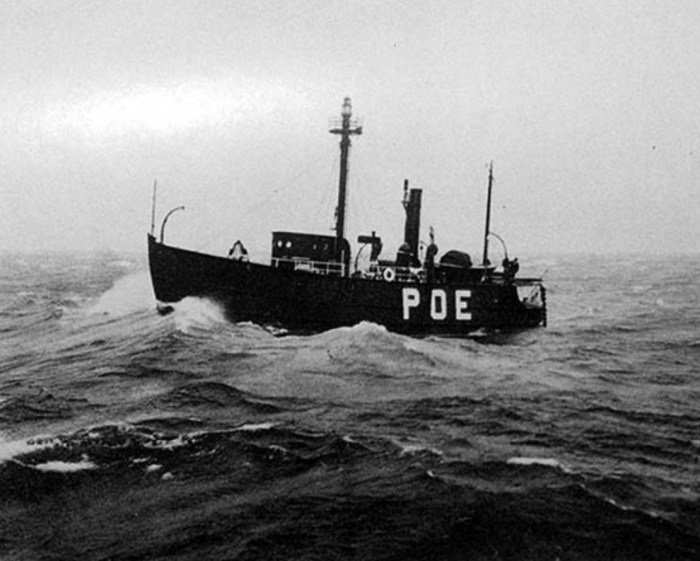
Poe Reef lies just eight feet beneath Lake Huron’s surface between Bois Blanc Island and the Lower Peninsula mainland. Terry Pepper’s Seeing the Light shares the story of Poe Reef Lightship LV62, launched on this day in 1893:

In 1892 two contracts totaling $55,960 were awarded to the Craig Shipbuilding Company in Toledo for the construction of four lightships. Designated as Lightships LV59, LV60, LV61 and LV62, all four vessels were built to similar specifications. Framed and planked of white oak they measured 87′ 2″ inches in length, 21′ 6″ inches in the beam, with a draft of 8 feet. In a cost-cutting effort, the vessels were un-powered, outfitted with only a small riding sail carried on a short after mast. Equipped with a cluster of three oil-burning lens lanterns hoisted on their foremasts, each was also equipped with 6″ steam whistles and hand-operated bells for fog use. Work was completed on the four vessels the following year, and after sea trials, all four were commissioned by the Board and placed into service, LV59 being assigned to Bar Point, LV60 to Eleven Foot Shoal, LV61 to Corsica Shoal and LV62 to Poe Reef.

With the words POE REEF brightly painted in white on her fire engine red hull, LV62 was towed to Poe Reef by the lighthouse tender Marigold, and anchored on station to begin her vigil on September 29, 1893. For the next seventeen years LV62 spent every shipping season faithfully guarding the shoal. With the end of each shipping season, one of the lighthouse tenders would make the rounds of all lightship stations in the Straits area, and tow them into Cheboygan harbor for winter lay-up. While in Cheboygan, necessary repairs and improvements would be made in preparation for the following season. At some time in March or April, the ice would break up sufficiently to allow the vessels to be towed back to their stations to stand guard for yet another season.

Head over to Seeing the Light for more about Poe Reef Lighthouse & the stories of all Michigan’s lighthouses compiled by a champion for their preservation who has gone too soon.

Support Michigan in Pictures with Patreon

You’ve Got Mail

You've Got Mail by James Korringa

You’ve Got Mail by James Korringa

James took this on Bois Blanc Island. See more in his Barns & Countryside album on Flickr.

Support Michigan in Pictures with Patreon

Line 5 and the Great Lakes

Mackinaw-City-and-Mackinac-Bridge

Mackinaw City and Mackinac Bridge, photo by Sandy Hansen Photography 

“There is a pipeline that‘s sitting at the bottom of the Straits of Mackinac. It was designed for a 50 year life and it’s been down there for 63 years. There’s a risk involved in this.”
-Mark Shriberg, National Wildlife Federation

In Line 5 puts Great Lakes at risk on Absolute Michigan via the University of Michigan (video below):

Up to 152 miles (245 km) of coastline in lakes Huron and Michigan could be fouled by a single oil spill at the straits, according to the simulations. When all 840 simulated spills are plotted on a map, a total of 720 miles (1,162 km) of shoreline in the U.S. and Canada are considered potentially vulnerable to spills that would require cleanup. Seven hundred twenty miles is roughly the distance from Detroit to Atlanta.

Areas at highest risk include Mackinac and Bois Blanc islands, as well as locations directly east and west of Mackinaw City. Communities also at risk include Beaver Island, Cross Village, Harbor Springs, Cheboygan and other places along the lakes Huron-Michigan shoreline.

…”Until now, no one knew exactly how much shoreline was vulnerable to spills in the Straits of Mackinac,” said Schwab, a research scientist at the U-M Water Center. “These findings show that under the right conditions, a spill in the Straits of Mackinac could affect a significant amount of shoreline and open-water areas in either Lake Michigan or Lake Huron, or both, very quickly.”

View Sandy’s photo bigger, see more in her aerial slideshow, and follow her on at Sandy Hansen Photography on Facebook.


The Making of the Mackinac Bridge

Bridge_HDR2.jpg

Bridge HDR 2, photo by Allison Hopersberger

A calm night on the Straits of Mackinac, and Michigan’s signature bridge was looking fine!

I’ve posted a ton about the Mighty Mackinac Bridge here on Michigan in Pictures, but had never seen this excellent summary of how it came to be courtesy the Michigan Dept. of Transportation’s page on I-75 and the Straits of Mackinac:

The five-mile stretch of water separating Michigan’s two peninsulas, the result of glacial action some twelve thousand years ago, has long served as a major barrier to the movement of people and goods. The three railroads that reached the Straits of Mackinac in the early 1880s, the Michigan Central and the Grand Rapids & Indiana Railway from the south, and the Detroit, Mackinac and Marquette from the north, jointly established the Mackinac Transportation Company in 1881 to operate a railroad car ferry service across the straits. The railroads and their shipping lines developed Mackinac Island into a major vacation destination in the 1880s.

Improved highways along the eastern shores of Michigan’s lower peninsula brought increased automobile traffic to the straits region starting in the 1910s. The state of Michigan initiated an automobile ferry service between St. Ignace and Mackinaw City in 1923 and eventually operated eight ferry boats. In peak travel periods, particularly during deer season, five mile backups and delays of four hours or longer became common at the state docks at Mackinaw City and St. Ignace.

With increased public pressure to break this bottleneck, the Michigan legislature established a Mackinac Straits Bridge Authority in 1934, with the power to issue bonds for bridge construction. The bridge authority supported a proposal first developed in 1921 by Charles Evan Fowler, the bridge engineer who had previously promoted a Detroit-Windsor bridge. Fowler’s plans called for an island-hopping route from the city of Cheboygan to Bois Blanc, Round, and Mackinac islands, thence to St. Ignace, along a twenty-four-mile route. The Public Works Administration flatly rejected a request for loans and grants to implement this project.

A plan was then drawn up for a direct crossing from Mackinaw City to St. Ignace, but they were again denied funds. In 1940, a plan was submitted for a suspension bridge with a main span of 4600 feet. This design was a larger version of the ill-fated Tacoma Narrows Bridge in Washington State, a structure destroyed by high winds on November 7, 1940. Although the disaster delayed any further action, the activities of 1938-1940 nevertheless produced some important results. The bridge authority conducted a series of soundings and borings across the straits and built a causeway extending out 4200 feet from the St. Ignace shore. The Second World War ended any additional work, and the Legislature abolished the bridge authority in 1947.

William Stewart Woodfill, president of the Grand Hotel on Mackinac Island, almost singlehandedly resuscitated the dream of a bridge across the Straits of Mackinac. Woodfill formed the statewide Mackinac Bridge Citizens Committee in 1949 to lobby for a new bridge authority, which the legislature created in 1950. A panel of three prominent engineers conducted a feasibility study and made recommendations to the bridge authority on the location, structure, and design of the bridge.

The State Highway Department, which had just placed a $4.5 million ferryboat, Vacationland, into service at the straits in January 1952, remained hostile to the bridge plan. In April 1952, the Michigan legislature authorized the bridge authority to issue bonds for the project, choose an engineer, and proceed with construction. The authority selected David B. Steinman as the chief engineer in January 1953 and tried unsuccessfully to sell the bridge bonds in April 1953, but by the end of the year, the authority had sold the $99.8 million in revenue bonds needed to begin construction.

View Allison’s photo bigger and see LOTS more in her Mackinac Island slideshow!